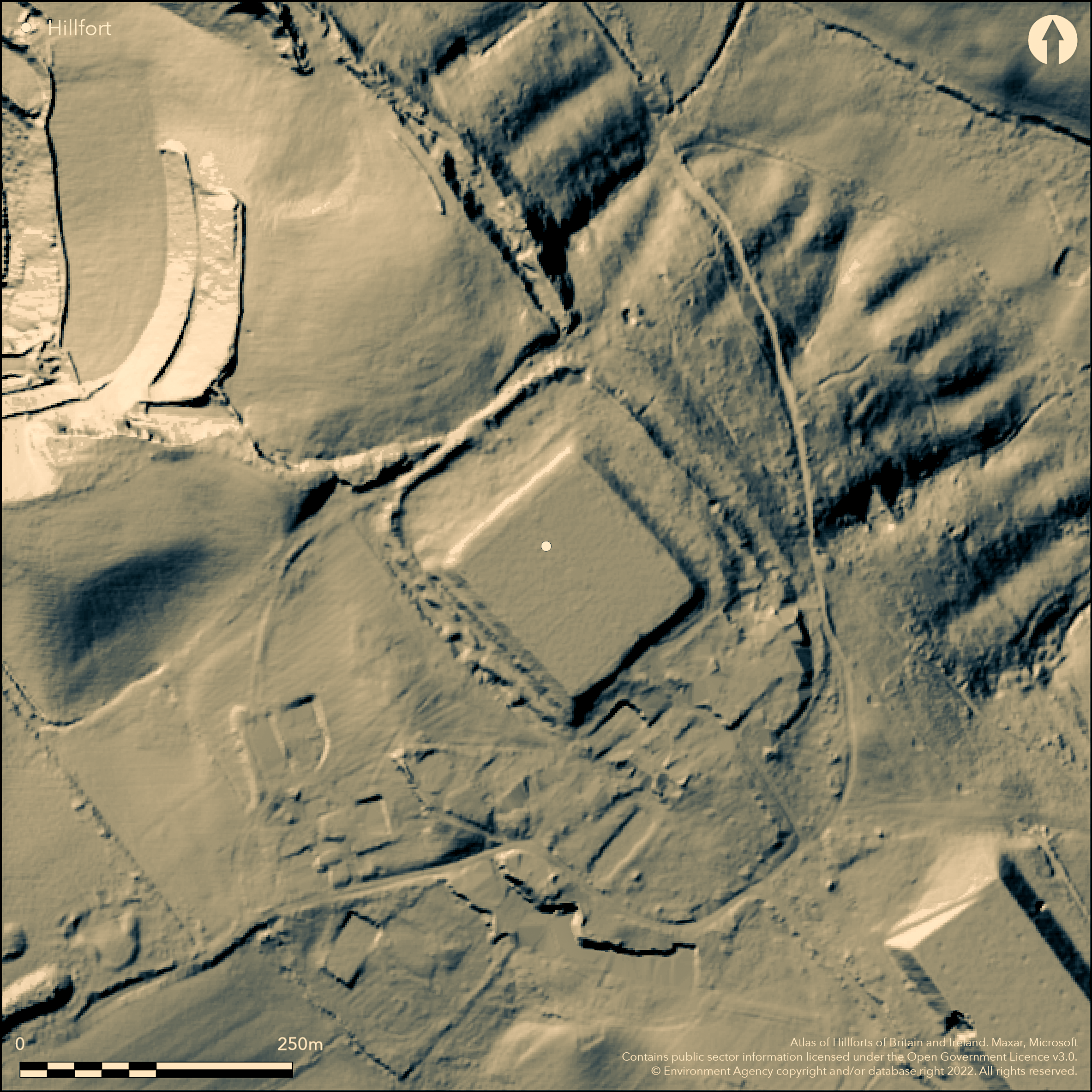
LiDAR 1m DTM Hillshade
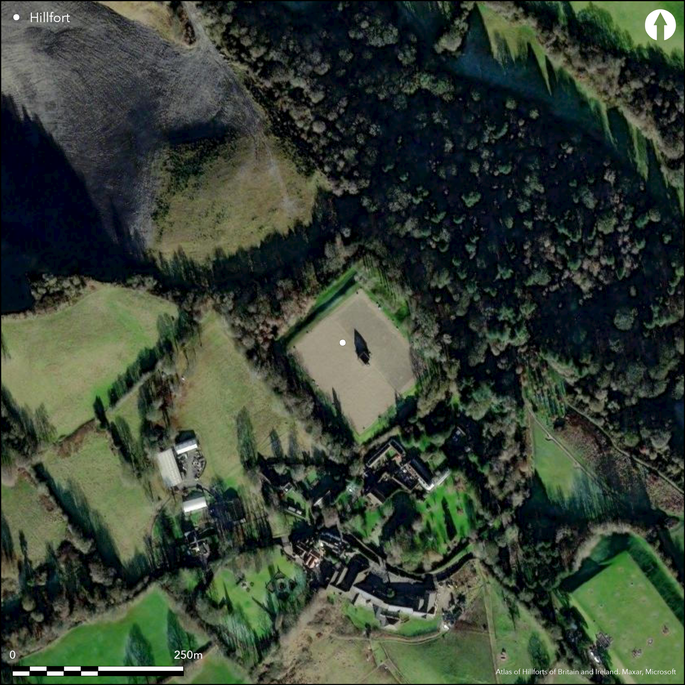
Satellite Imagery
LiDAR 1m DTM Hillshade
Satellite Imagery
Scroll left/right to view further images.
HER: Warwickshire 255 (None)
NMR: SP 39 SW 4 (336255)
SM: 1018855
NGR: SP 3135 9470
X: 431335 Y: 294714 (OSGB36)
Occupying a prominent ridge 200m to the N of Oldbury Grange, a univallate hillfort of approximately 2.0ha. It lies at 175m OD commanding views across the vale of Leicestershire. Sub-square in form comprising a bank with a maximum width of 6.5m at its base and an external ditch which is now infilled. The earthworks are best preserved in the NW but appear absent in the SE.The ground falls away in the SW and NE and there is evidence of scarping to form outer defences. Trial trenching in 1949 in advance of the reservoir showed that the ramparts were constructed of diorite rubble held by a heavy line of packing (Dauncey 1949). Internal quarry hollows and a ditch were also observed. Breaks lie in the NW corner, NE corner and the centre of the rampart in the NE. A causeway across the ditch in the NW suggests this is the original entrance with the others being later breaks. The earthworks in the SE were extensively altered by the construction of Oldbury Hall, a Georgian house, demolished in 1948. A reservoir has operated within the centre of the hillfort since 1954. Skeletons were recovered during the construction of a house in the 1950, dated by Birmingham University to the first millennium BC and recorded on the 1956 Ordnance Survey Iron Age Map of Southern Britain. An archaeological watching brief and trenching in 1993 by Birmingham University Field Archaeology Unit (BUFAU) during the construction of a waterfeed pipeline did not produce any further archaeological data (Jones 1993). No dating evidence was recovered during the excavations and the site remains undated. The bank and ditch in the NW have been damaged by quarrying. An unverified report exists of flint axes being recovered from the 'north part of the fort' (Dugdale 1730 cited in VCH). The site is recorded on 1889 1:2,500 OS mapping. Scheduled.
Citizen Science: ✗
Reliability of Data: Confirmed
Reliability of Interpretation: Confirmed
X: -171357 Y: 6900071 (EPSG: 3857)
Longitude: -1.5393250065994237 Latitude: 52.54934819588683 (EPSG:4326)
Country: England; None
Current County or Unitary Authority: Warwickshire
Historic County: Warwickshire
Current Parish/Community/Council/Townland: Hartshill; Mancetter; Hartshill
Destroyed in the SE. Included in the 2015 Heritage at Risk Register with principal vulnerability from scrub and tree growth.
| Extant | ✓ |
| Cropmark | ✗ |
| Likely Destroyed | ✓ |
Buildings and covered reservoir
| Woodland | ✓ |
| Commercial Forestry Plantation | ✗ |
| Parkland | ✗ |
| Pasture (Grazing) | ✗ |
| Arable | ✗ |
| Scrub/Bracken | ✗ |
| Bare Outcrop | ✗ |
| Heather/Moorland | ✗ |
| Heath | ✗ |
| Built-up | ✓ |
| Coastal Grassland | ✗ |
| Other | ✗ |
A hillslope fort lying on a prominent ridge at 175m OD.
| Contour Fort | ✗ |
| Partial Contour Fort | ✗ |
| Promontory Fort | ✗ |
| Hillslope Fort | ✓ |
| Level Terrain Fort | ✗ |
| Marsh Fort | ✗ |
| Multiple Enclosure Fort | ✗ |
| Hilltop | ✓ |
| Coastal Promontory | ✗ |
| Inland Promontory | ✗ |
| Valley Bottom | ✗ |
| Knoll/Hillock/Outcrop | ✗ |
| Ridge | ✓ |
| Cliff/Plateau-edge/Scarp | ✗ |
| Hillslope | ✓ |
| Lowland | ✗ |
| Spur | ✗ |
Dominant Topographic Feature: Prominent ridge
| North | ✗ |
| Northeast | ✓ |
| East | ✗ |
| Southeast | ✗ |
| South | ✗ |
| Southwest | ✗ |
| West | ✗ |
| Northwest | ✗ |
| Level | ✗ |
Altitude: 175.0m
Parish boundaries with Hartshill and Mancetter lie close by to the N and S
Boundary Type: Parish/Townland
Unverified report of flint axes being found (Dugdale 1730)
Reliability: D - None
| Pre 1200BC | ✗ |
| 1200BC - 800BC | ✗ |
| 800BC - 400BC | ✗ |
| 400BC - AD50 | ✗ |
| AD50 - AD400 | ✗ |
| AD400 - AD 800 | ✗ |
| Post AD800 | ✗ |
| Unknown | ✓ |
| Pre Hillfort: | None |
| Post Hillfort: | Georgian House, reservoir. |
Report by Dugdale (1730) of axes from the site. Recorded on 1889 OS mapping. Trial trenching in 1949 in advance of the reservoir (Dauncey 1949); field investigations in 1951 and 1967. Archaeological watching brief in 1993 (Jones 1993). Scheduled
| 1st Identified Written Reference (1730): | None |
| 1st Identified Map Depiction (1889): | None |
| Excavation (1949): | None |
| Other (1951): | Field investigation |
| Other (1967): | Field investigation |
| Other (1981): | Scheduled |
| Other (1993): | Watching brief |
No internal features are recorded. Human bones and late Iron Age pottery.
None
| None | ✓ |
| Spring | ✗ |
| Stream | ✗ |
| Pool | ✗ |
| Flush | ✗ |
| Well | ✗ |
| Other | ✗ |
None
| No Known Features | ✓ |
| Round Stone Structures | ✗ |
| Rectangular Stone Structures | ✗ |
| Curvilinear Platforms | ✗ |
| Other Roundhouse Evidence | ✗ |
| Pits | ✗ |
| Quarry Hollows | ✗ |
| Other | ✗ |
None
| No Known Excavation | ✗ |
| Pits | ✗ |
| Postholes | ✗ |
| Roundhouses | ✗ |
| Rectangular Structures | ✗ |
| Roads/Tracks | ✗ |
| Quarry Hollows | ✗ |
| Other | ✗ |
| Nothing Found | ✓ |
None
| No Known Geophysics | ✓ |
| Pits | ✗ |
| Roundhouses | ✗ |
| Rectangular Structures | ✗ |
| Roads/Tracks | ✗ |
| Quarry Hollows | ✗ |
| Other | ✗ |
| Nothing Found | ✗ |
Found during construction of a house
| No Known Finds | ✗ |
| Pottery | ✓ |
| Metal | ✗ |
| Metalworking | ✗ |
| Human Bones | ✓ |
| Animal Bones | ✗ |
| Lithics | ✗ |
| Environmental | ✗ |
| Other | ✗ |
None
| APs Not Checked | ✓ |
| None | ✗ |
| Roundhouses | ✗ |
| Rectangular Structures | ✗ |
| Pits | ✗ |
| Postholes | ✗ |
| Roads/Tracks | ✗ |
| Other | ✗ |
Breaks lie in the NW corner, NE corner and the centre of the rampart in the NE. A causeway across the ditch in the NW suggests this is the original entrance with the others being later breaks.
| 3: | None |
| 2: | None |
Guard Chambers: ✗
Chevaux de Frise: ✗
| 1. Other Forms (North west): | Causeway across ditch |
Sub-square comprising a bank with a maximum width of 6.5m at its base and an external ditch which is now infilled. Best preserved in the NW, absent in the SE. The ground falls away in the SW and NE and there is evidence of scarping to form outer defences. The ramparts were constructed of diorite rubble held by a heavy line of packing (Dauncey 1949).
| Area 1: | 2.0ha. |
| Total: | 2.0ha. |
Total Footprint Area: Noneha.
None
| ✗ | None |
| ✗ | None |
| NE Quadrant: | 1 |
| SE Quadrant: | None |
| SW Quadrant: | 1 |
| NW Quadrant: | 1 |
| Total: | 1 |
| Partial Univallate | ✓ |
| Univallate | ✗ |
| Partial Bivallate | ✗ |
| Bivallate | ✗ |
| Partial Multivallate | ✗ |
| Multivallate | ✗ |
| Unknown | ✗ |
| Partial Univallate | ✗ |
| Univallate | ✗ |
| Partial Bivallate | ✗ |
| Bivallate | ✗ |
| Partial Multivallate | ✗ |
| Multivallate | ✗ |
None
| None | ✗ |
| Earthen Bank | ✓ |
| Stone Wall | ✓ |
| Rubble | ✗ |
| Wall-walk | ✗ |
| Evidence of Timber | ✗ |
| Vitrification | ✗ |
| Other Burning | ✗ |
| Palisade | ✗ |
| Counter Scarp Bank | ✗ |
| Berm | ✗ |
| Unfinished | ✗ |
| Other | ✗ |
Ramparts constructed of diorite rubble held by a heavy line of packing (Dauncey 1949).
| None | ✗ |
| Earthen Bank | ✗ |
| Stone Wall | ✗ |
| Murus Duplex | ✗ |
| Timber-framed | ✗ |
| Timber-laced | ✗ |
| Vitrification | ✗ |
| Other Burning | ✗ |
| Palisade | ✗ |
| Counter Scarp Bank | ✗ |
| Berm | ✗ |
| Unfinished | ✗ |
| No Known Excavation | ✗ |
| Other | ✓ |
| ✗ | None |
| ✓ | None |
Number of Ditches: 1
| ✗ | None |
Dauncey, K.D.M. 1949. Oldbury, Excavation 1949: Advance summary (unpublished),
Doubleday, H. A. and Page, W. (eds) 1904. Victoria County History, Warwickshire, Vol 1. 376-8
Dugdale, W. 1730. Antiquities of Warwickshire.
Ferris, I. M., Sterenberg, J. 1992. An Archaeological Evaluation at Oldbury Camp, near Nuneaton. Birmingham University Field Archaeology Unit Report in, Vol. 206, (1992)
Jones, A. E. 1993. Oldbury Camp, Near Nuneaton, Warwickshire; an archaeological watching brief. Birmingham University Field Archaeology Unit.
Atlas of Hillforts:
Wikidata:
This work is licensed under CC BY-SA 4.0

 and should be cited as:
Lock, Gary and Ralston, Ian. 2024. Atlas of Hillforts of Britain and Ireland. Available at: https://hillforts.arch.ox.ac.uk
Document Version 1.1