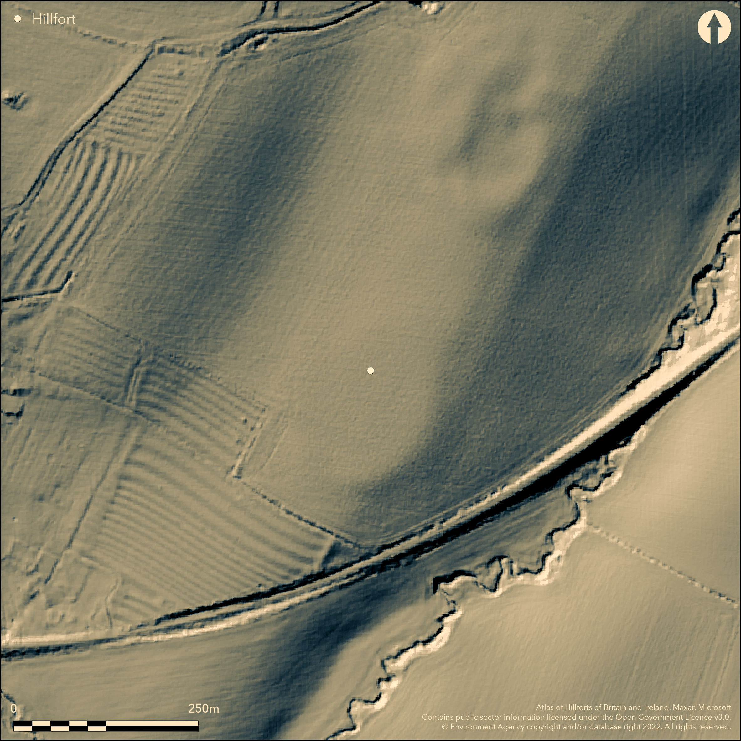
LiDAR 1m DTM Hillshade
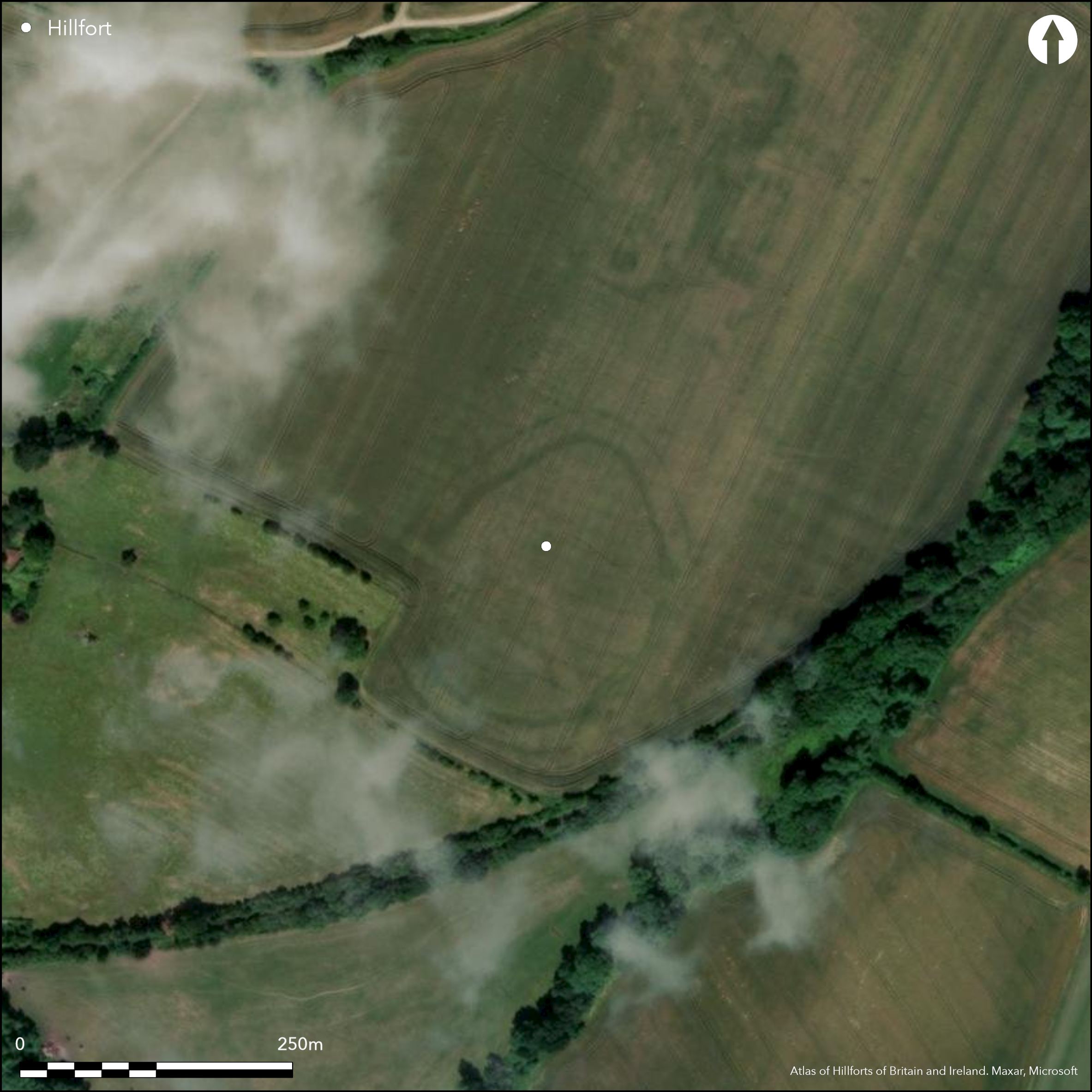
Satellite Imagery
LiDAR 1m DTM Hillshade
Satellite Imagery
Scroll left/right to view further images.
HER: Warwickshire 1258 (None)
NMR: SP 25 SE 2 (333196)
SM: 1002990
NGR: SP 27768 50342
X: 427768 Y: 250342 (OSGB36)
Lying approximately 1.5km to the NE of Ettington and 600m to the SE of Thornton Wood, the cropmarks of a large double-ditched sub-oval enclosure, originally interpreted as a henge but subsequently suggested to be a hillfort or other Iron Age site (Thomas 1974; 40, Plate 1b). A wide inner ditch can be seen on aerial photographs and traces of an internal bank survive in the S. Opposing entrances lie in the E and W. A small annex has been recorded in the SE. It overlies the cropmark of a narrow rectangular feature suggested by Harding and Lee (1987) to be a Neolithic curses, although this is disputed and it might be geological. A semicircular stone scatter 7.6 to 9.1m wide was observed within the outer ditch after ploughing in 1978. Iron Age pottery sherds, worked flints, a small piece of copper and a piece of cremated bone have also been recovered from the surface. Medieval and post medieval ridge and furrow ploughing has been recorded across the site and traces of old field boundaries can be seen on aerial photographs. The site is not recorded on OS mapping.
Citizen Science: ✗
Reliability of Data: Confirmed
Reliability of Interpretation: Confirmed
X: -177620 Y: 6827408 (EPSG: 3857)
Longitude: -1.5955852846097667 Latitude: 52.150631731897924 (EPSG:4326)
Country: England
Current County or Unitary Authority: Warwickshire
Historic County: Warwickshire
Current Parish/Community/Council/Townland: Ettington
None
| Extant | ✗ |
| Cropmark | ✓ |
| Likely Destroyed | ✗ |
None
| Woodland | ✗ |
| Commercial Forestry Plantation | ✗ |
| Parkland | ✗ |
| Pasture (Grazing) | ✗ |
| Arable | ✓ |
| Scrub/Bracken | ✗ |
| Bare Outcrop | ✗ |
| Heather/Moorland | ✗ |
| Heath | ✗ |
| Built-up | ✗ |
| Coastal Grassland | ✗ |
| Other | ✗ |
A possible hillslope fort lying on a southeasterly slope at approximately 77m OD
| Contour Fort | ✗ |
| Partial Contour Fort | ✗ |
| Promontory Fort | ✗ |
| Hillslope Fort | ✓ |
| Level Terrain Fort | ✗ |
| Marsh Fort | ✗ |
| Multiple Enclosure Fort | ✗ |
| Hilltop | ✗ |
| Coastal Promontory | ✗ |
| Inland Promontory | ✗ |
| Valley Bottom | ✗ |
| Knoll/Hillock/Outcrop | ✗ |
| Ridge | ✗ |
| Cliff/Plateau-edge/Scarp | ✗ |
| Hillslope | ✓ |
| Lowland | ✓ |
| Spur | ✗ |
Dominant Topographic Feature: Hillslope
| North | ✗ |
| Northeast | ✗ |
| East | ✗ |
| Southeast | ✓ |
| South | ✗ |
| Southwest | ✗ |
| West | ✗ |
| Northwest | ✗ |
| Level | ✗ |
Altitude: 77.0m
N/A
The site is undated
Reliability: D - None
| Pre 1200BC | ✗ |
| 1200BC - 800BC | ✗ |
| 800BC - 400BC | ✗ |
| 400BC - AD50 | ✗ |
| AD50 - AD400 | ✗ |
| AD400 - AD 800 | ✗ |
| Post AD800 | ✗ |
| Unknown | ✓ |
| Pre Hillfort: | None |
| Post Hillfort: | Ridge and furrow recorded across the site |
Included in the transcript of a report by Hobley in 1962. Description and plan produced by Hingley (1984) held in HER, Mapped as part of the SE Warwickshire & Cotswolds HLS NMP survey. Field investigation in 1962. Scheduled as a double-ditched enclosure.
| 1st Identified Written Reference (1962): | None |
| Other (1962): | Field investigation |
| Earthwork Survey (1984): | None |
| Other (None): | NMP |
| Other (None): | Scheduled |
No internal features are recorded. Cremated bone recovered. Report does not state if human or animal
A stream lies to the S
| None | ✓ |
| Spring | ✗ |
| Stream | ✗ |
| Pool | ✗ |
| Flush | ✗ |
| Well | ✗ |
| Other | ✗ |
None
| No Known Features | ✓ |
| Round Stone Structures | ✗ |
| Rectangular Stone Structures | ✗ |
| Curvilinear Platforms | ✗ |
| Other Roundhouse Evidence | ✗ |
| Pits | ✗ |
| Quarry Hollows | ✗ |
| Other | ✗ |
None
| No Known Excavation | ✓ |
| Pits | ✗ |
| Postholes | ✗ |
| Roundhouses | ✗ |
| Rectangular Structures | ✗ |
| Roads/Tracks | ✗ |
| Quarry Hollows | ✗ |
| Other | ✗ |
| Nothing Found | ✗ |
None
| No Known Geophysics | ✓ |
| Pits | ✗ |
| Roundhouses | ✗ |
| Rectangular Structures | ✗ |
| Roads/Tracks | ✗ |
| Quarry Hollows | ✗ |
| Other | ✗ |
| Nothing Found | ✗ |
Small piece of copper. Cremated bone assumed here to be human
| No Known Finds | ✗ |
| Pottery | ✓ |
| Metal | ✗ |
| Metalworking | ✗ |
| Human Bones | ✓ |
| Animal Bones | ✗ |
| Lithics | ✓ |
| Environmental | ✗ |
| Other | ✓ |
None
| APs Not Checked | ✗ |
| None | ✓ |
| Roundhouses | ✗ |
| Rectangular Structures | ✗ |
| Pits | ✗ |
| Postholes | ✗ |
| Roads/Tracks | ✗ |
| Other | ✗ |
Opposing entrances lie in the E and W
| 2: | None |
| 2: | None |
Guard Chambers: ✗
Chevaux de Frise: ✗
| 1. Simple Gap (East): | None |
| 2. Simple Gap (West): | None |
Cropmarks of a large double-ditched sub-oval enclosure. A wide inner ditch can be seen on aerial photographs and traces of an internal bank survive in the S.
| Area 1: | Noneha. |
| Total: | Noneha. |
Total Footprint Area: Noneha.
None
| ✗ | None |
| ✓ | None |
| NE Quadrant: | 2 |
| SE Quadrant: | 2 |
| SW Quadrant: | 2 |
| NW Quadrant: | 2 |
| Total: | 2 |
| Partial Univallate | ✗ |
| Univallate | ✗ |
| Partial Bivallate | ✗ |
| Bivallate | ✓ |
| Partial Multivallate | ✗ |
| Multivallate | ✗ |
| Unknown | ✗ |
| Partial Univallate | ✗ |
| Univallate | ✗ |
| Partial Bivallate | ✗ |
| Bivallate | ✗ |
| Partial Multivallate | ✗ |
| Multivallate | ✗ |
Report of traces of an internal bank surviving in the S
| None | ✗ |
| Earthen Bank | ✓ |
| Stone Wall | ✗ |
| Rubble | ✗ |
| Wall-walk | ✗ |
| Evidence of Timber | ✗ |
| Vitrification | ✗ |
| Other Burning | ✗ |
| Palisade | ✗ |
| Counter Scarp Bank | ✗ |
| Berm | ✗ |
| Unfinished | ✗ |
| Other | ✗ |
None
| None | ✗ |
| Earthen Bank | ✗ |
| Stone Wall | ✗ |
| Murus Duplex | ✗ |
| Timber-framed | ✗ |
| Timber-laced | ✗ |
| Vitrification | ✗ |
| Other Burning | ✗ |
| Palisade | ✗ |
| Counter Scarp Bank | ✗ |
| Berm | ✗ |
| Unfinished | ✗ |
| No Known Excavation | ✓ |
| Other | ✗ |
| ✗ | None |
| ✓ | None |
Number of Ditches: 2
| ✓ | A small annex has been recorded in the SE |
Harding, A.F. and Lee, G.E. 1987. Henge monuments and related sites of Great Britain: air photographic evidence and catalogue. BAR British series 1 (1974), 175, 281-3.
Thomas, N. 1974. An archaeological gazetteer for Warwickshire: Neolithic to Iron Age. Trans Birm Warwicks Archaeol Soc, 86, 16-48.
Atlas of Hillforts:
Wikidata:
This work is licensed under CC BY-SA 4.0

 and should be cited as:
Lock, Gary and Ralston, Ian. 2024. Atlas of Hillforts of Britain and Ireland. Available at: https://hillforts.arch.ox.ac.uk
Document Version 1.1