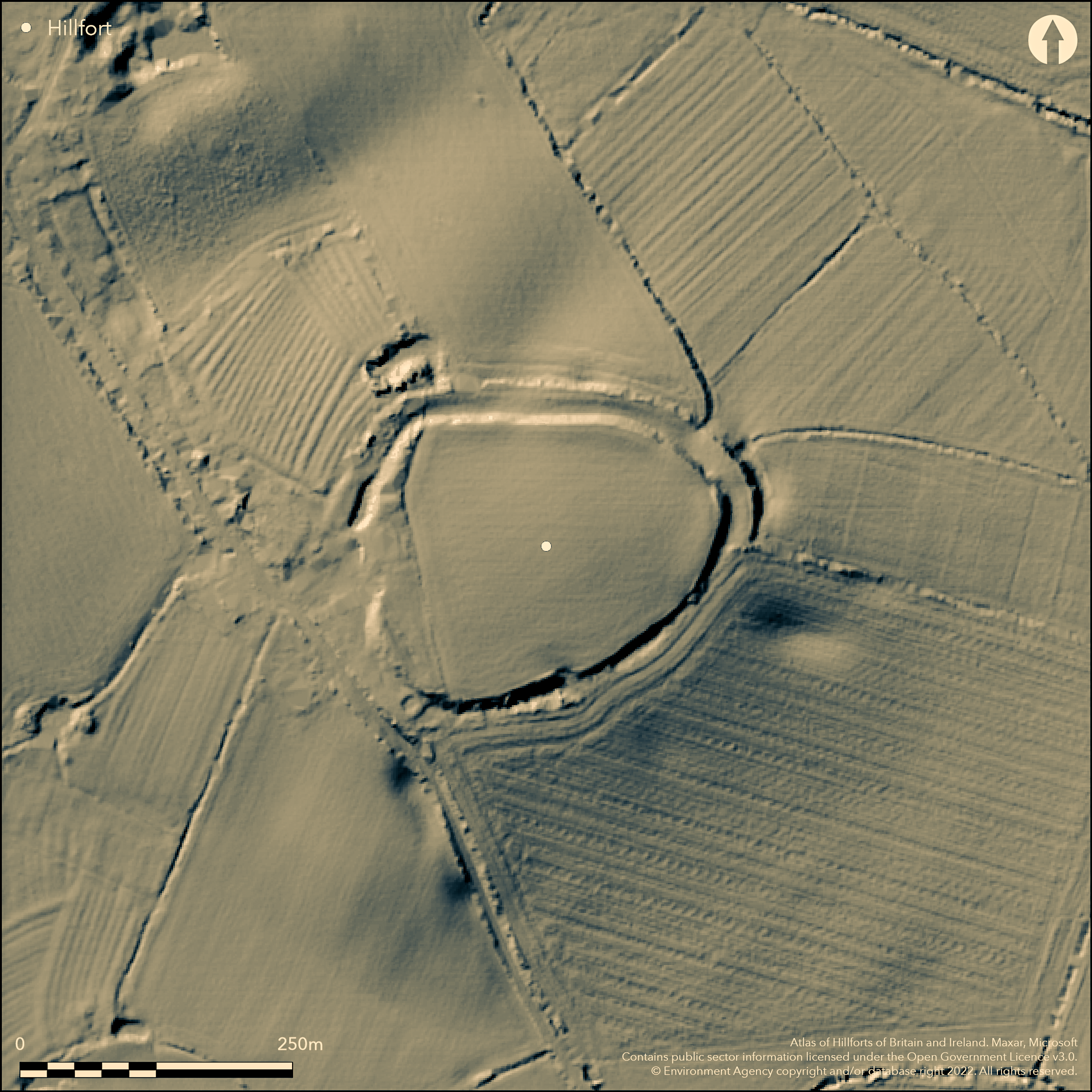
LiDAR 1m DTM Hillshade
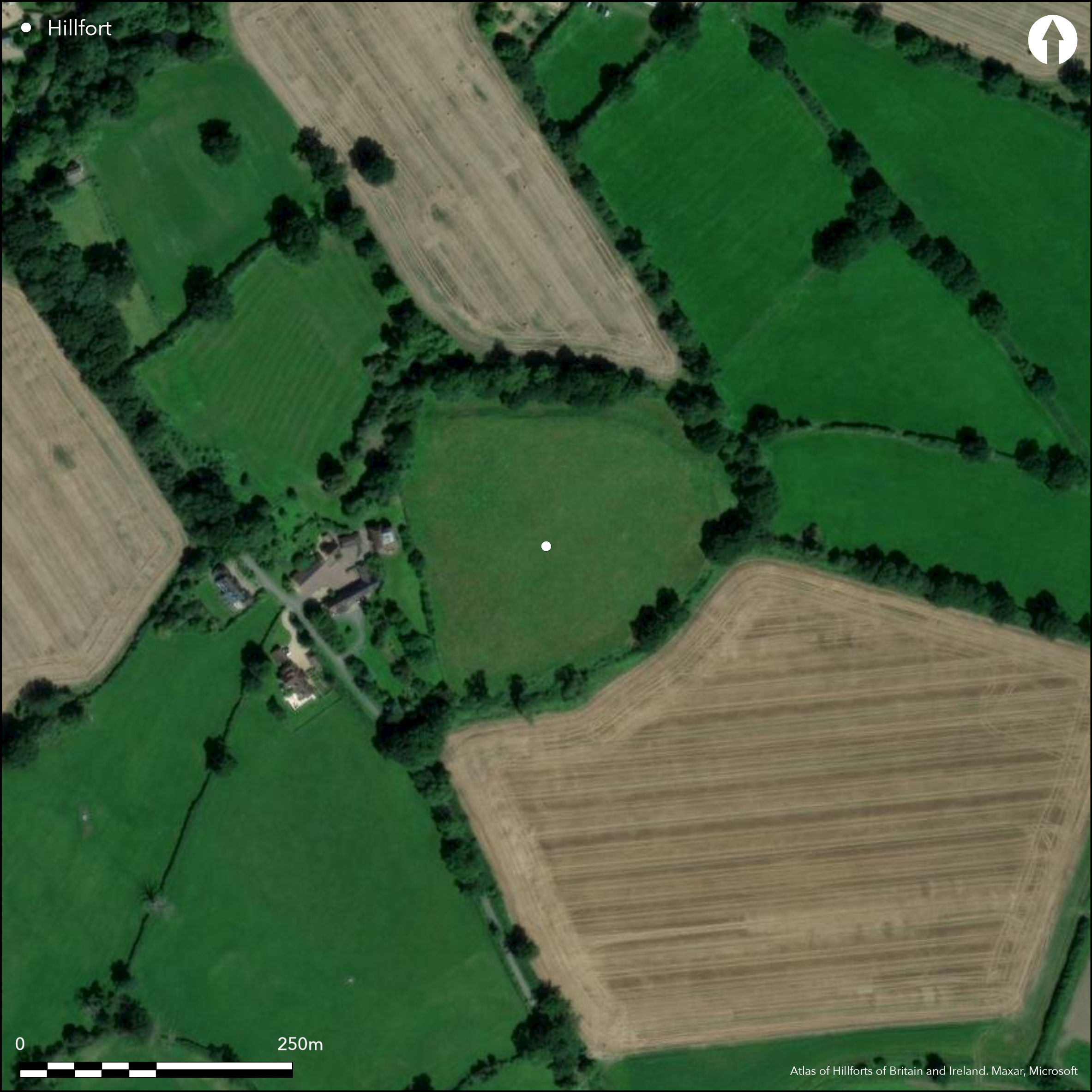
Satellite Imagery
LiDAR 1m DTM Hillshade
Satellite Imagery
Scroll left/right to view further images.
HER: Warwickshire 2655 (None)
NMR: SP 27 SW 12 (334005)
SM: 1011370
NGR: SP 24665 70138
X: 424665 Y: 270138 (OSGB36)
A bivallate hillfort sited at 116m OD on a high ridge of land running between the villages of Haseley and Honiley known as Camp Hill. Beyond it, the land slopes away in the N, S and E and its location offers extensive views in these directions. Oval in form it has an external measurement of 230m W-E and 180m N-S formed of two banks and two ditches, the innermost bank is now denuded in places and the ditches infilled. The inner ditch is best preserved in the S where a 16m length survives. The outer ditch survives in the E. The denuded outer bank, which survives along the N and E edges measures 12m wide across the base. No evidence survives for an original entrance although it might have lain at the western edge which is now destroyed by Camphill Farm and associated buildings. A break in the SE is probably more recent. Internally the land rises above the surrounding ground surface measuring 90m E-W by 130m N-S occupying an area of approximately 1.9ha. It is now under cultivation. A subterranean chamber was discovered in the SE and in moving a timber-framed house from a location nearer the road to its present location, two large iron cannon balls were discovered, believed by Burgess (1873, 41) to be artefacts left by troops en-route to Meriden Camp in 1745. Two gold pins are said to have been discovered during excavations in c.1922 (newspaper article held in HER). Damage to the site has occurred through erosion and agriculture and the construction of Camphill Farm. Recorded on 1887 1:2,500 OS mapping. Undated. Scheduled
Citizen Science: ✗
Reliability of Data: Confirmed
Reliability of Interpretation: Confirmed
X: -182508 Y: 6859788 (EPSG: 3857)
Longitude: -1.6394970727895903 Latitude: 52.328751163205936 (EPSG:4326)
Country: England
Current County or Unitary Authority: Warwickshire
Historic County: Warwickshire
Current Parish/Community/Council/Townland: Beausale
Damaged through erosion and agriculture
| Extant | ✓ |
| Cropmark | ✗ |
| Likely Destroyed | ✓ |
None
| Woodland | ✗ |
| Commercial Forestry Plantation | ✗ |
| Parkland | ✗ |
| Pasture (Grazing) | ✗ |
| Arable | ✓ |
| Scrub/Bracken | ✗ |
| Bare Outcrop | ✗ |
| Heather/Moorland | ✗ |
| Heath | ✗ |
| Built-up | ✗ |
| Coastal Grassland | ✗ |
| Other | ✗ |
A contour fort lying at 115m OD on level ground on a high ridge of land on Camp Hill
| Contour Fort | ✓ |
| Partial Contour Fort | ✗ |
| Promontory Fort | ✗ |
| Hillslope Fort | ✗ |
| Level Terrain Fort | ✗ |
| Marsh Fort | ✗ |
| Multiple Enclosure Fort | ✗ |
| Hilltop | ✓ |
| Coastal Promontory | ✗ |
| Inland Promontory | ✗ |
| Valley Bottom | ✗ |
| Knoll/Hillock/Outcrop | ✗ |
| Ridge | ✓ |
| Cliff/Plateau-edge/Scarp | ✗ |
| Hillslope | ✗ |
| Lowland | ✗ |
| Spur | ✗ |
Dominant Topographic Feature: High ridge
| North | ✗ |
| Northeast | ✗ |
| East | ✗ |
| Southeast | ✗ |
| South | ✗ |
| Southwest | ✗ |
| West | ✗ |
| Northwest | ✗ |
| Level | ✓ |
Altitude: 115.0m
N/A
The site is undated
Reliability: D - None
| Pre 1200BC | ✗ |
| 1200BC - 800BC | ✗ |
| 800BC - 400BC | ✗ |
| 400BC - AD50 | ✗ |
| AD50 - AD400 | ✗ |
| AD400 - AD 800 | ✗ |
| Post AD800 | ✗ |
| Unknown | ✓ |
| Pre Hillfort: | None |
| Post Hillfort: | Modern farm buildings |
| Morphology/Earthwork/Typology: | None |
Recorded on 1887 1:2,500 OS mapping. Mentioned in Burgess (1873). Plan shown in in VCH (1904). Newspaper article outlining finds from excacation c.1922. Field investigations 1968, 1976. Scheduled.
| 1st Identified Written Reference (1873): | None |
| 1st Identified Map Depiction (1887): | None |
| Earthwork Survey (1904): | Possibly based on plan made in 1837 and subsequent plan |
| Other (1925): | Scheduled |
| Other (1968): | Field investigation |
| Other (1976): | Field investigation |
| Excavation (None): | No further information |
Internally the land rises above the surrounding ground surface measuring 90m W-E by 130m N-S and occupying an area of approximately 1.3ha. No features are recorded
Ponds and wells shown in the vicinity of the enclosure on historic OS mapping, with one on the rampart in the E. The ditches are reputed to hold water
| None | ✓ |
| Spring | ✗ |
| Stream | ✗ |
| Pool | ✗ |
| Flush | ✗ |
| Well | ✗ |
| Other | ✗ |
None
| No Known Features | ✓ |
| Round Stone Structures | ✗ |
| Rectangular Stone Structures | ✗ |
| Curvilinear Platforms | ✗ |
| Other Roundhouse Evidence | ✗ |
| Pits | ✗ |
| Quarry Hollows | ✗ |
| Other | ✗ |
No features recorded
| No Known Excavation | ✗ |
| Pits | ✗ |
| Postholes | ✗ |
| Roundhouses | ✗ |
| Rectangular Structures | ✗ |
| Roads/Tracks | ✗ |
| Quarry Hollows | ✗ |
| Other | ✗ |
| Nothing Found | ✓ |
None
| No Known Geophysics | ✓ |
| Pits | ✗ |
| Roundhouses | ✗ |
| Rectangular Structures | ✗ |
| Roads/Tracks | ✗ |
| Quarry Hollows | ✗ |
| Other | ✗ |
| Nothing Found | ✗ |
Two gold pins
| No Known Finds | ✗ |
| Pottery | ✗ |
| Metal | ✓ |
| Metalworking | ✗ |
| Human Bones | ✗ |
| Animal Bones | ✗ |
| Lithics | ✗ |
| Environmental | ✗ |
| Other | ✗ |
None
| APs Not Checked | ✓ |
| None | ✗ |
| Roundhouses | ✗ |
| Rectangular Structures | ✗ |
| Pits | ✗ |
| Postholes | ✗ |
| Roads/Tracks | ✗ |
| Other | ✗ |
No evidence survives for an original entrance although it might have lain at the western edge which is now destroyed by Camphill Farm and associated buildings. A break in the SE is probably more recent.
| 1: | None |
| 2: | None |
Guard Chambers: ✗
Chevaux de Frise: ✗
Oval in form with an external measurement of 230m W-E and 180m N-S. Originally formed of two banks and two ditches, the innermost bank is now denuded in places and the ditches infilled. The inner ditch is best preserved in the S where a 16m length survives. The outer ditch survives in the E. The denuded outer bank, which survives along the N and E edges measures 12m wide across the base.
| Area 1: | 2.3ha. |
| Total: | 2.3ha. |
Total Footprint Area: 2.8ha.
None
| ✗ | Estimated from satellite imagery |
| ✓ | None |
| NE Quadrant: | 2 |
| SE Quadrant: | 2 |
| SW Quadrant: | 2 |
| NW Quadrant: | 2 |
| Total: | 2 |
| Partial Univallate | ✗ |
| Univallate | ✗ |
| Partial Bivallate | ✗ |
| Bivallate | ✓ |
| Partial Multivallate | ✗ |
| Multivallate | ✗ |
| Unknown | ✗ |
| Partial Univallate | ✗ |
| Univallate | ✗ |
| Partial Bivallate | ✗ |
| Bivallate | ✗ |
| Partial Multivallate | ✗ |
| Multivallate | ✗ |
None
| None | ✗ |
| Earthen Bank | ✓ |
| Stone Wall | ✗ |
| Rubble | ✗ |
| Wall-walk | ✗ |
| Evidence of Timber | ✗ |
| Vitrification | ✗ |
| Other Burning | ✗ |
| Palisade | ✗ |
| Counter Scarp Bank | ✗ |
| Berm | ✗ |
| Unfinished | ✗ |
| Other | ✗ |
None
| None | ✓ |
| Earthen Bank | ✗ |
| Stone Wall | ✗ |
| Murus Duplex | ✗ |
| Timber-framed | ✗ |
| Timber-laced | ✗ |
| Vitrification | ✗ |
| Other Burning | ✗ |
| Palisade | ✗ |
| Counter Scarp Bank | ✗ |
| Berm | ✗ |
| Unfinished | ✗ |
| No Known Excavation | ✗ |
| Other | ✗ |
| ✗ | None |
| ✓ | None |
Number of Ditches: 2
| ✗ | None |
Burgess, J.T. 1873. Ancient British Remains and Earthworks in the Forest of Arden. J Brit Archaeol Ass. 41.
Doubleday, H. A. and Page, W. (eds) 1904. Victoria County History, Warwickshire, Vol 1. 357-8.
Thomas, N. 1974. An archaeological gazetteer for Warwickshire: Neolithic to Iron Age. Trans Birm Warwicks Archaeol Soc, 86, 16-48.
Atlas of Hillforts:
Wikidata:
This work is licensed under CC BY-SA 4.0

 and should be cited as:
Lock, Gary and Ralston, Ian. 2024. Atlas of Hillforts of Britain and Ireland. Available at: https://hillforts.arch.ox.ac.uk
Document Version 1.1