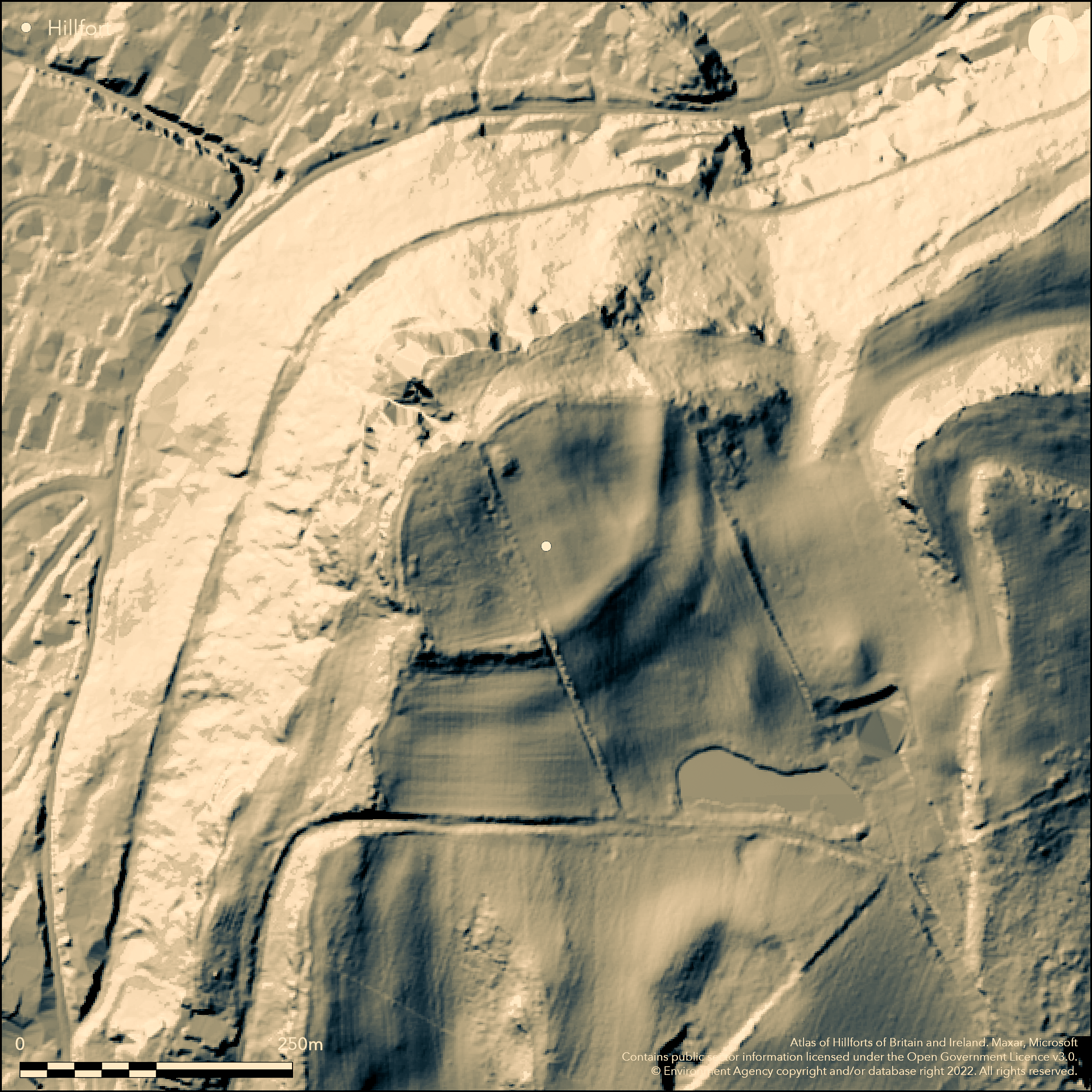
LiDAR 1m DTM Hillshade
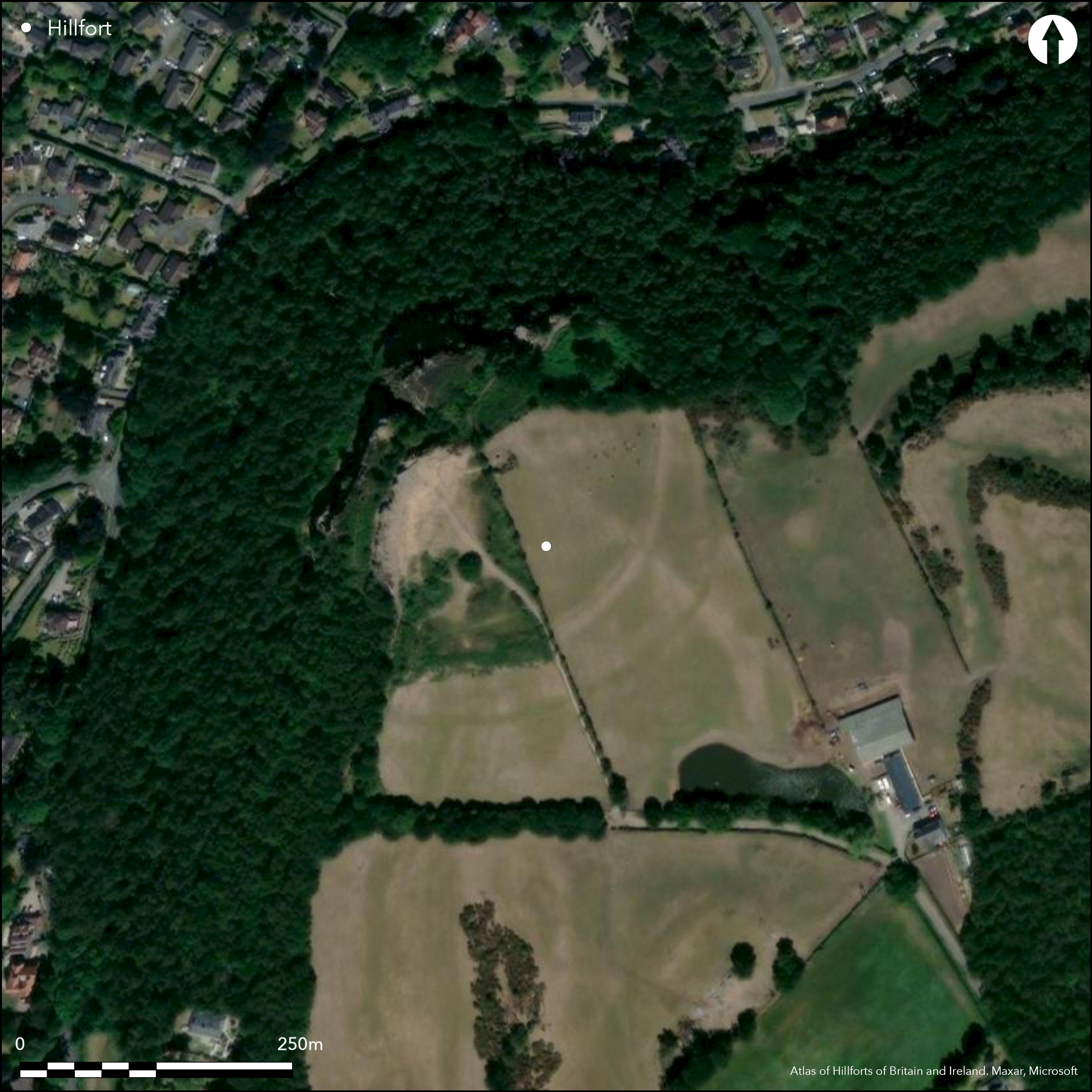
Satellite Imagery
LiDAR 1m DTM Hillshade
Satellite Imagery
Scroll left/right to view further images.
HER: Cheshire MCH8237 (1007/2)
NMR: SJ 47 NE 4 (69518)
SM: 1013292
NGR: SJ49277539
X: 349270 Y: 375390 (OSGB36)
Bivallate inland promontory fort located in prominent and commanding position on a WNW-facing spur of the central red sandstone ridge which bisects Cheshire and is high above River Mersey Estuary. Extensive views over the River Mersey Estuary and plain to W, and Delamere Forest to E. Woodhouses (Atlas No. 3186) on Woodhouse Hill 2km to NE. Precipitous cliffs, with a subsidiary cliff to the rock-face on the N and W sides of the promontory, dropping to what was probably marsh land below, but to E and S the land rises gradually to the ramparts of the fort. Here site defined by two curving ramparts from NE-SW, with medial ditch and to S of outer rampart, enclosing area c. 2.2ha. Interesting possible original entrance, where single inturn of inner rampart at SW end allows gap of c. 10m before cliff edge reached. Possible later addition. S and E part of site within cultivated fields and severely degraded as a result. Outer bank more or less gone in W field and outer ditch infilled and only identifiable from the air. Both ramparts in E field only c.0.4m high and medial ditch only just visible. Infilled outer ditch now only a cropmark. Excavations by J.D. Bu'Lock 1955 and J. Forde-Johnston 1964. Section cut through S side of outer rampart in 1955 found bank of box construction, with central core of rock, rubble and sand, and revetted with dry-stone sandstone blocks c. 1m wide, and laced with timbers across the width; whole originally at least 3.5m wide at base and estimated to 2.5m high. In addition, stone revetting shows in soil of E field suggesting that inner rampart of similar construction. Bu'Lock also recovered layer of burnt sand containing charcoal and fire-cracked potboilers. Site of Royal Observer Corps monitoring post. National Trust site. Bracken control measures. Investigated under the local authority and partners Habitats and Hillforts Landscape Partnership Scheme 2007-2011, with small excavation 2010 and geophysical surveys and LiDar surveys 2009 and 2010 respectively. Possible middle Bronze Age origins with use to mid Iron Age. Part National Trust and part private landowner site. W part of site under rough grass, bracken, scrub, trees and bare rock. S and E part of site within cultivated fields. Wooded surrounding slopes to N and W. Bracken control measures. On 1st Ed. OS map (1873-74).
Citizen Science: ✗
Reliability of Data: Confirmed
Reliability of Interpretation: Confirmed
X: -307486 Y: 7033664 (EPSG: 3857)
Longitude: -2.762193100317168 Latitude: 53.27304429199621 (EPSG:4326)
Country: England
Current County or Unitary Authority: Cheshire West and Chester
Historic County: Cheshire
Current Parish/Community/Council/Townland: Helsby
Part National Trust and part private landowner site. Bracken control measures. S and E part of site within cultivated fields and severely degraded as a result. Parts of site to E now only a cropmark. Site of Royal Observer Corps monitoring post. Cold War bunker constructed in interior 1950's. Site prominent from M56 motorway below. On Heritage at Risk Register (2015).
| Extant | ✓ |
| Cropmark | ✓ |
| Likely Destroyed | ✗ |
W part of site under rough grass, bracken, scrub, trees and bare rock. S and E part of site within cultivated fields. Wooded surrounding slopes to N and W.
| Woodland | ✗ |
| Commercial Forestry Plantation | ✗ |
| Parkland | ✓ |
| Pasture (Grazing) | ✓ |
| Arable | ✗ |
| Scrub/Bracken | ✓ |
| Bare Outcrop | ✗ |
| Heather/Moorland | ✗ |
| Heath | ✗ |
| Built-up | ✗ |
| Coastal Grassland | ✗ |
| Other | ✗ |
Bivallate inland promontory fort located in prominent and commanding position on a WNW-facing spur of the central red sandstone ridge which bisects Cheshire and is high above River Mersey Estuary. Extensive views over the River Mersey Estuary and plain to W, and Delamere Forest to E. Precipitous cliffs, with a subsidiary cliff to the rock-face, defend site on the N and W sides of the promontory, dropping to what was probably marsh land below, but to E and S the land rises gradually to the defending ramparts of the fort.
| Contour Fort | ✗ |
| Partial Contour Fort | ✗ |
| Promontory Fort | ✓ |
| Hillslope Fort | ✗ |
| Level Terrain Fort | ✗ |
| Marsh Fort | ✗ |
| Multiple Enclosure Fort | ✗ |
| Hilltop | ✗ |
| Coastal Promontory | ✗ |
| Inland Promontory | ✓ |
| Valley Bottom | ✗ |
| Knoll/Hillock/Outcrop | ✗ |
| Ridge | ✗ |
| Cliff/Plateau-edge/Scarp | ✗ |
| Hillslope | ✗ |
| Lowland | ✗ |
| Spur | ✗ |
Dominant Topographic Feature: Spur
| North | ✗ |
| Northeast | ✗ |
| East | ✗ |
| Southeast | ✗ |
| South | ✗ |
| Southwest | ✗ |
| West | ✗ |
| Northwest | ✓ |
| Level | ✗ |
Altitude: 141.0m
N/A
Excavations 2010 found possible middle Bronze Age origins, with C14 date from charcoal-rich silt of inner face of earliest rampart dated to 1435-1320 BC. Late bronze Age C14 dates of 1250-1050 BC from wood charcoal higher up sequence. Grains of charred wheat from interior posthole C14 dated to 210-90 BC showing possible occupation to middle Iron Age.
Reliability: A - High
| Pre 1200BC | ✓ |
| 1200BC - 800BC | ✓ |
| 800BC - 400BC | ✓ |
| 400BC - AD50 | ✓ |
| AD50 - AD400 | ✗ |
| AD400 - AD 800 | ✗ |
| Post AD800 | ✗ |
| Unknown | ✗ |
| Pre Hillfort: | None |
| Post Hillfort: | None |
| C14: | C14 date of 3950-3780 from wood charcoal above bedrock. Charcoal-rich silt of inner face of earliest rampart dated to 1435-1320 BC. Late bronze Age C14 dates of 1250-1050 BC from wood charcoal higher up sequence. Grains of charred wheat from interior posthole C14 dated to 210-90 BC. |
| Morphology/Earthwork/Typology: | General features show similarities to other Cheshire hillforts. |
On 1st Ed. OS map (1873-74). Excavation by J.D. Bu'Lock 1955. Excavation by J. Forde-Johnston 1964. Investigated under the local authority and partners Habitats and Hillforts Landscape Partnership Scheme 2007-2011, with small excavation by Liverpool University, 2010 and geophysical surveys and LiDar surveys 2009 and 2010 respectively.
| Excavation (1955): | J.D. Bu'Lock. |
| Excavation (1964): | J. Forde-Johnston. |
| Geophysical Survey (2009): | Liverpool University. |
| Earthwork Survey (2010): | Habitats and Hillforts Landscape Partnership Scheme. |
| LiDAR Survey (2010): | Habitats and Hillforts Landscape Partnership Scheme. |
| Excavation (2010): | Habitats and Hillforts Landscape Partnership Scheme team. |
| 1st Identified Map Depiction (None): | OS map. |
Large stone-packed posthole, with possible timber evidence, from Forde-Johnston's trench, re-examined 2010. Use unknown, but possible building or part of rampart structure. Geophysics not conclusive, but circular features identified as possible roundhouses. Bu'Lock (1955) recovered layer of burnt sand containing charcoal and fire-cracked potboilers. Charcoal, charred wheat grains and pollen from 2010 excavation. Socketed Ewart Park possible from site 1935, but uncertain. Roman coin of Tiberius of AD 22 found in interior.
None
| None | ✓ |
| Spring | ✗ |
| Stream | ✗ |
| Pool | ✗ |
| Flush | ✗ |
| Well | ✗ |
| Other | ✗ |
None
| No Known Features | ✓ |
| Round Stone Structures | ✗ |
| Rectangular Stone Structures | ✗ |
| Curvilinear Platforms | ✗ |
| Other Roundhouse Evidence | ✗ |
| Pits | ✗ |
| Quarry Hollows | ✗ |
| Other | ✗ |
Large stone-packed posthole, with possible timber evidence, from Forde-Johnston's trench, re-examined 2010. Use unknown, but possible building or part of rampart structure.
| No Known Excavation | ✗ |
| Pits | ✗ |
| Postholes | ✓ |
| Roundhouses | ✗ |
| Rectangular Structures | ✗ |
| Roads/Tracks | ✗ |
| Quarry Hollows | ✗ |
| Other | ✗ |
| Nothing Found | ✗ |
Geophysics not conclusive, but circular features identified as possible roundhouses.
| No Known Geophysics | ✗ |
| Pits | ✗ |
| Roundhouses | ✓ |
| Rectangular Structures | ✗ |
| Roads/Tracks | ✗ |
| Quarry Hollows | ✗ |
| Other | ✗ |
| Nothing Found | ✗ |
Bu'Lock recovered layer of burnt sand containing charcoal and fire-cracked potboilers. Charcoal, charred wheat grains and pollen from 2010 excavation. Socketed Ewart Park possible from site 1935, but uncertain. Roman coin of Tiberius of AD 22 found in interior.
| No Known Finds | ✗ |
| Pottery | ✗ |
| Metal | ✗ |
| Metalworking | ✗ |
| Human Bones | ✗ |
| Animal Bones | ✗ |
| Lithics | ✓ |
| Environmental | ✓ |
| Other | ✗ |
None
| APs Not Checked | ✓ |
| None | ✗ |
| Roundhouses | ✗ |
| Rectangular Structures | ✗ |
| Pits | ✗ |
| Postholes | ✗ |
| Roads/Tracks | ✗ |
| Other | ✗ |
Interesting possible original entrance, where single inturn of inner rampart at SW end allows gap of c. 10m before cliff edge reached. Undated, but may be a later Iron Age addition. Modern gap in inner rampart where the end of the lane to S enters the enclosure.
| 2: | Modern gap in inner rampart where the end of the lane to S enters the enclosure. |
| 2: | None |
Guard Chambers: ✗
Chevaux de Frise: ✗
| 1. In-turned (South west): | None |
Section cut through S side of outer rampart in 1955 found bank of box construction, with central core of rock, rubble and sand, and revetted with dry-stone sandstone blocks c. 1m wide, and laced with timbers across the width; whole originally at least 3.5m wide at base and estimated to 2.5m high. In addition, stone revetting shows in soil of E field suggesting that inner rampart of similar construction.
| Area 1: | 2.2ha. |
| Total: | 2.2ha. |
Total Footprint Area: Noneha.
None
| ✗ | None |
| ✗ | Ramparts curve in arc from NE-SW quadrants. |
| NE Quadrant: | 2 |
| SE Quadrant: | 2 |
| SW Quadrant: | 2 |
| NW Quadrant: | 0 |
| Total: | 2 |
| Partial Univallate | ✗ |
| Univallate | ✗ |
| Partial Bivallate | ✓ |
| Bivallate | ✗ |
| Partial Multivallate | ✗ |
| Multivallate | ✗ |
| Unknown | ✗ |
| Partial Univallate | ✗ |
| Univallate | ✗ |
| Partial Bivallate | ✗ |
| Bivallate | ✗ |
| Partial Multivallate | ✗ |
| Multivallate | ✗ |
Sand and rubble of outer rampart exposed when ploughed or on aerial photographs. Possible outer 'counterscarp' bank, identified from LiDar and aerial photographs (Garner, 2012, 55).
| None | ✗ |
| Earthen Bank | ✓ |
| Stone Wall | ✗ |
| Rubble | ✓ |
| Wall-walk | ✗ |
| Evidence of Timber | ✗ |
| Vitrification | ✗ |
| Other Burning | ✗ |
| Palisade | ✗ |
| Counter Scarp Bank | ✓ |
| Berm | ✗ |
| Unfinished | ✗ |
| Other | ✗ |
Section cut through S side of outer rampart in 1955 found bank of box construction, with central core of rock, rubble and sand, and revetted with dry-stone sandstone blocks c. 1m wide, and laced with timbers across the width; whole originally at least 3.5m wide at base and estimated to 2.5m high. In addition, stone revetting shows in soil of E field suggesting that inner rampart of similar construction. Re-examine 2010.
| None | ✗ |
| Earthen Bank | ✓ |
| Stone Wall | ✓ |
| Murus Duplex | ✗ |
| Timber-framed | ✗ |
| Timber-laced | ✓ |
| Vitrification | ✗ |
| Other Burning | ✗ |
| Palisade | ✗ |
| Counter Scarp Bank | ✗ |
| Berm | ✗ |
| Unfinished | ✗ |
| No Known Excavation | ✗ |
| Other | ✗ |
| ✗ | None |
| ✓ | Medial ditch and to S of outer rampart. Ditches infilled in places. |
Number of Ditches: 2
| ✗ | None |
Brown, I. 2009. Beacons in the landscape. The hillforts of England and Wales, Oxford: Windgather Press/Oxbow Books.
Bu'Lock, J.D. 1956. The hill-fort at Helsby, Cheshire, Trans Lancashire Cheshire Antiq Soc, 66, 107-10.
Forde-Johnston, J. 1962. The Iron Age hill-forts of Lancashire and Cheshire, Trans Lancashire Cheshire Antiq Soc, 72, 21-2.
Garner, D. 2012. Hillforts of the Cheshire Sandstone Ridge, Monograph, Habitats and Hillforts Landscape Partnership Scheme, Chester: Cheshire West and Chester Council.
Garner, D. 2014. Helsby Hill to Maiden Castle: Prehistoric forts of the Cheshire Ridge, In ed. Saunders, T., Hillforts in the North West and Beyond, Archaeological North West: New Series, 3 (2014), Council for British Archaeology North West, 28-41.
Garner, D. 2016. Hillforts of the Cheshire Ridge. Investigations undertaken by the Habitats and Hillforts Landscape Partnership Scheme 2009-2012. Oxford: Archaeopress.
Morgan, V. and Morgan, P. 2004, Prehistoric Cheshire, Landmark Collector's Library, Ashbourne: Landmark Publishing, 145.
Atlas of Hillforts:
Wikidata:
This work is licensed under CC BY-SA 4.0

 and should be cited as:
Lock, Gary and Ralston, Ian. 2024. Atlas of Hillforts of Britain and Ireland. Available at: https://hillforts.arch.ox.ac.uk
Document Version 1.1