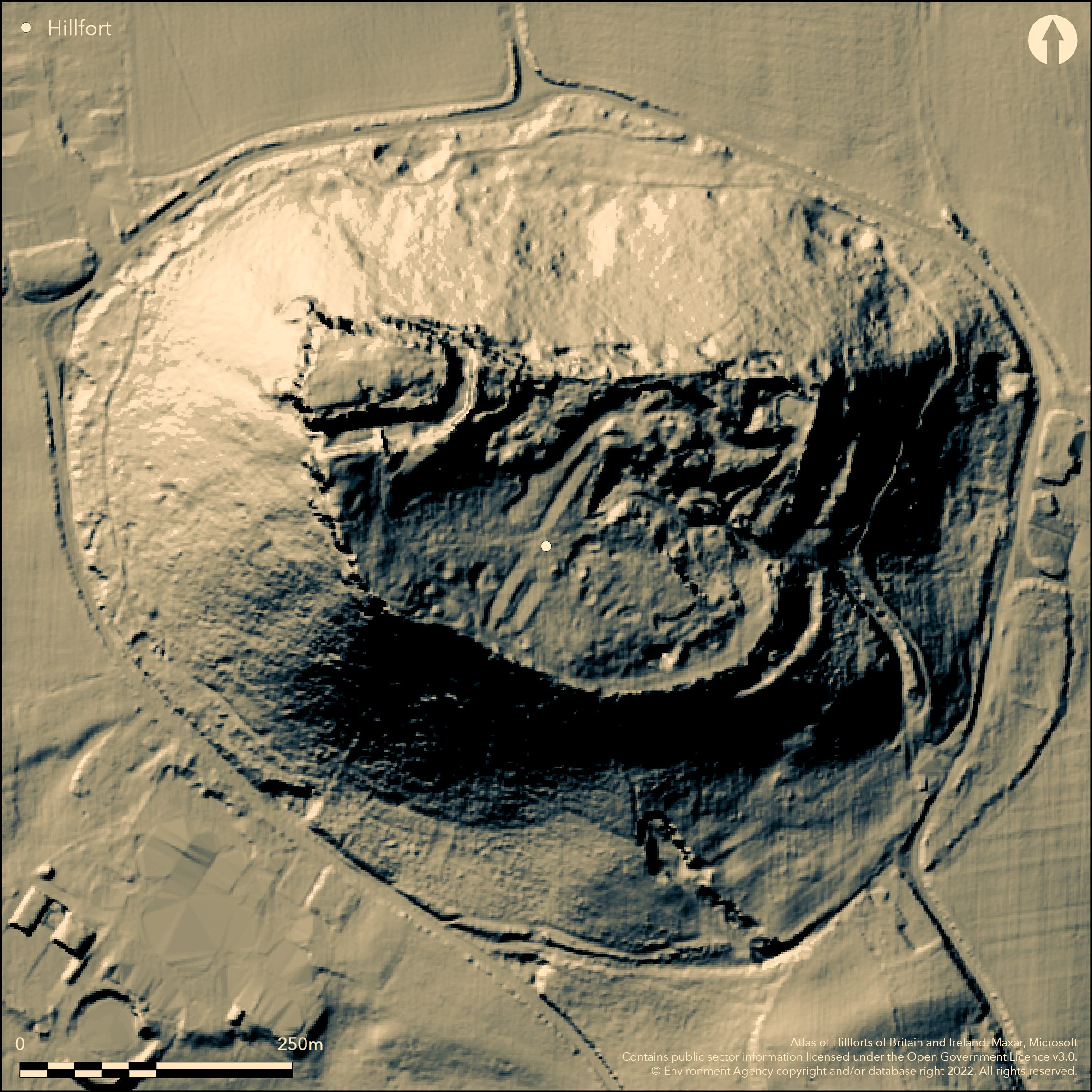
LiDAR 1m DTM Hillshade
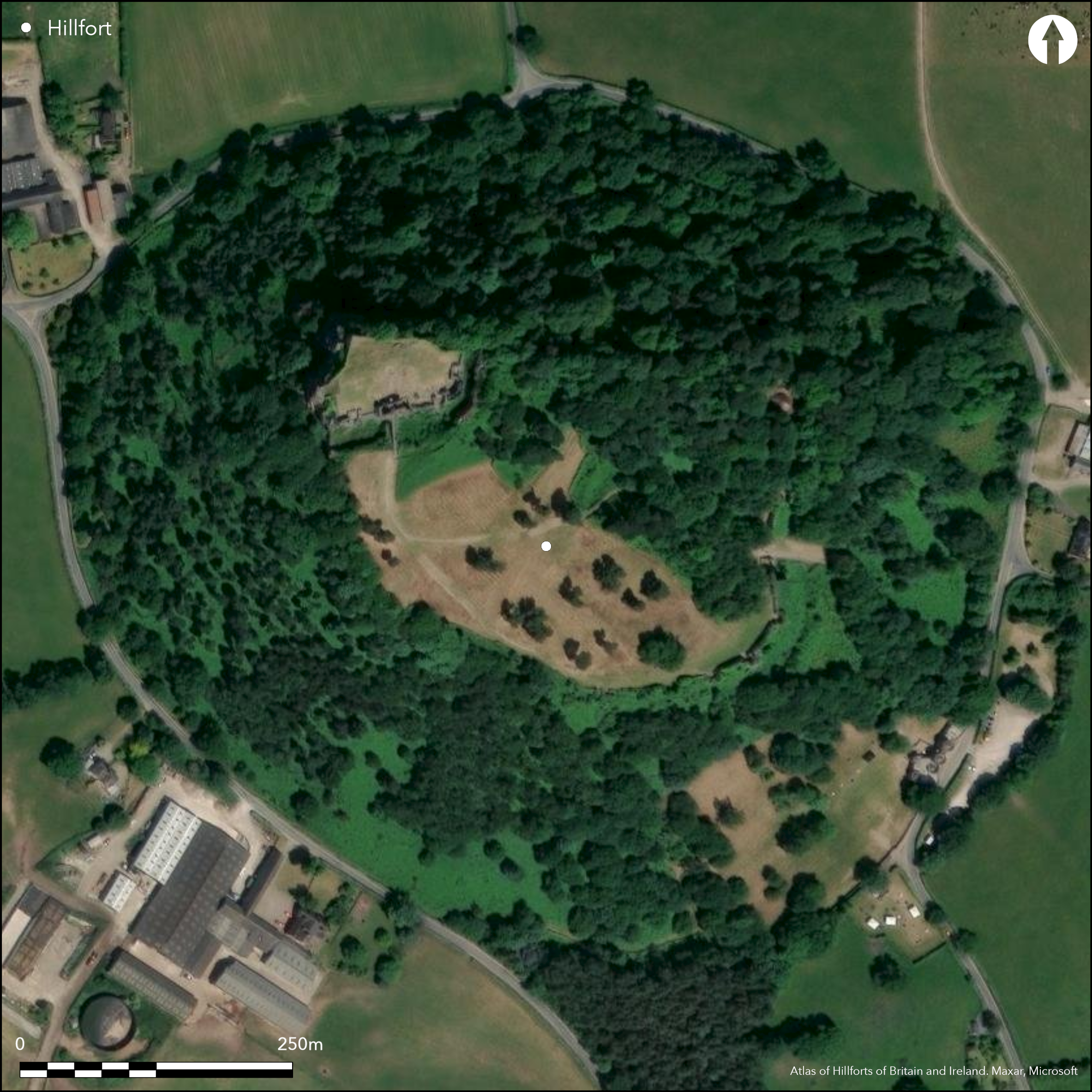
Satellite Imagery
LiDAR 1m DTM Hillshade
Satellite Imagery
Scroll left/right to view further images.
HER: Cheshire MCH1415 (1732/1/1-3)
NMR: SJ 55 NW 3 (1913)
SM: 1007900
NGR: SJ53795919
X: 353793 Y: 359194 (OSGB36)
Excavated inland promontory hillfort located on prominent and commanding sandstone outcrop at N end of Peckforton Hills, the S-most hills of the Mid-Cheshire Ridge. Extensive views from summit to Cheshire Plain below, and as far as Mersey Estuary to N, The Wrekin (Atlas No. 0090) to S, the Pennines to E and Welsh mountains to W. Precipitous crags to N and W, very steep elsewhere. Site surmounted by 13th century castle ruins with keep on NW. Bank cuts off the promontory on E, but whether there were additional ramparts on the N, S and W covered by later castle not investigated, encloses 4.0ha. Excavation proved long occupation of site from Neolithic to late Bronze Age hillfort origins (foundation deposits of socketed and looped axe heads of 900-700 BC) and later Iron Age hillfort. Excavated by L. Keen 1968-73 and P. Hough 1975-85. Early phase suggested by postholes of possible palisaded Neolithic settlement near outer gate and Outer Ward of castle. Later timber-laced bank, with no ditch and simple entrance, between c. 900 BC - 650 BC, with metalworking. Area then woodland with some clearance for crops. Then two final complex Iron Age phases, in more open landscape, which overlay rampart. First a larger timber with sand core rampart, deep ditch and inturned passageway entrance. Postholes and slingstones found. Then final phase between c. 450 BC and first century BC sand and timber framed rampart overlain by rubble box bank revetted by two lines of boulders, with timber (oak and ash) palisade or timber walkway (Morgan and Morgan 2004, 149). Large quantities of burnt material suggest possible deliberate slighting similar to Castle Ditches, Eddisbury (Atlas No. 3187) and Maiden Castle, Bickerton (Atlas No. 3189). Charred emmer and spelt grains over large area and associated with number of pits and postholes (146 rock-cut in Outer Ward), suggesting possible grain storage and/or at least nine roundhouses of either late Bronze Age of Iron Age date (area later disturbed). High-status finds - leather rivetted drinking vessel with ornate bronze rim and fittings; imported copper alloy bracelet, Bronze and Iron Age shale rings, beads, swan's neck pin, weapon and horse harness parts and many domestic artefacts and bone. Investigated under the local authority and partners Habitats and Hillforts Landscape Partnership Scheme 2007-2011. On 1st Ed. OS map (1874-75).
Citizen Science: ✗
Reliability of Data: Confirmed
Reliability of Interpretation: Confirmed
X: -299675 Y: 7006688 (EPSG: 3857)
Longitude: -2.692024936194805 Latitude: 53.12788256420219 (EPSG:4326)
Country: England
Current County or Unitary Authority: Cheshire West and Chester
Historic County: Cheshire
Current Parish/Community/Council/Townland: Beeston
English Heritage medieval castle site.
| Extant | ✓ |
| Cropmark | ✗ |
| Likely Destroyed | ✓ |
Scrubby.
| Woodland | ✗ |
| Commercial Forestry Plantation | ✗ |
| Parkland | ✗ |
| Pasture (Grazing) | ✗ |
| Arable | ✗ |
| Scrub/Bracken | ✓ |
| Bare Outcrop | ✗ |
| Heather/Moorland | ✗ |
| Heath | ✗ |
| Built-up | ✗ |
| Coastal Grassland | ✗ |
| Other | ✓ |
Inland promontory hillfort located on prominent and commanding sandstone outcrop at N end of Peckforton Hills, the S-most hills of the Mid-Cheshire Ridge. Extensive views from summit to Cheshire Plain below, and as far as Mersey Estuary to N, The Wrekin (Atlas No. 0090) to S, the Pennines to E and Welsh mountains to W. Precipitous crags to N and W, very steep elsewhere. Bank cuts off the promontory on E, giving a promontory fort today, but whether there were additional defences on the N, S and W covered by later castle not investigated.
| Contour Fort | ✗ |
| Partial Contour Fort | ✗ |
| Promontory Fort | ✓ |
| Hillslope Fort | ✗ |
| Level Terrain Fort | ✗ |
| Marsh Fort | ✗ |
| Multiple Enclosure Fort | ✗ |
| Hilltop | ✗ |
| Coastal Promontory | ✗ |
| Inland Promontory | ✓ |
| Valley Bottom | ✗ |
| Knoll/Hillock/Outcrop | ✓ |
| Ridge | ✗ |
| Cliff/Plateau-edge/Scarp | ✗ |
| Hillslope | ✗ |
| Lowland | ✗ |
| Spur | ✗ |
Dominant Topographic Feature: Sandstone outcrop.
| North | ✗ |
| Northeast | ✗ |
| East | ✗ |
| Southeast | ✗ |
| South | ✗ |
| Southwest | ✗ |
| West | ✗ |
| Northwest | ✗ |
| Level | ✓ |
Altitude: 160.0m
N/A
Excavation proved long occupation of site from Neolithic to late Bronze Age hillfort origins and later Iron Age hillfort. Neolithic palisaded enclosure, late Bronze Age to 650 BC and two Iron Age phases of 650 BC - first century BC. Foundation deposits of five Ewart Park socketed axe heads of 900-700 BC and other metalwork. Fragments of Beaker pottery. Roman-British and medieval pottery. 17 radiocarbon dates. Horn (Forthcoming) suggests the hillfort start (Phase 2B): 900-700 BC, Hillfort upkeep (Phase 3A): 500-400 BC, Hillfort refortification (Phase 3B): 410-200 cal. BC, Hillfort end: 200 BC.
Reliability: A - High
| Pre 1200BC | ✗ |
| 1200BC - 800BC | ✓ |
| 800BC - 400BC | ✓ |
| 400BC - AD50 | ✓ |
| AD50 - AD400 | ✗ |
| AD400 - AD 800 | ✗ |
| Post AD800 | ✗ |
| Unknown | ✗ |
| Pre Hillfort: | None |
| Post Hillfort: | None |
| Artefactual: | Pottery and other evidence. |
| C14: | None |
| Other: | Archaeomagnetic date of 510-290 BC. |
On 1st Ed. OS map (1874-75). Excavations by Laurence Keen 1968-73 and Peter Hough, 1975-85. Geophysical survey for previous years excavations of P. Hough 1981. Watching Briefs - Matrix Archaeology 2008. Investigated under the local authority and partners Habitats and Hillforts Landscape Partnership Scheme 2007-2011, LiDAR. geophysical survets Engineering Archaeological Services, 2009, 2010.
| Geophysical Survey (1981): | For previous years excavations of P. Hough. |
| Other (2008): | Watching Briefs - Matrix Archaeology. |
| LiDAR Survey (2009): | None |
| 1st Identified Map Depiction (None): | OS map. |
| Excavation (None): | L. Keen. |
| Excavation (None): | P. Hough |
| Other (None): | Habitats and Hillforts Landscape Partnership Scheme. |
| Geophysical Survey (None): | Engineering Archaeological Services. |
Number of pits and postholes (146 rock-cut in Outer Ward), suggesting possible grain storage and/or at least nine roundhouses of either late Bronze Age of Iron Age date (area later disturbed). Evidence of late Bronze Age metalworking. Foundation deposits of five Ewart Park socketed and looped axe heads of 900-700 BC, sword fragment and spear head. Charred emmer and spelt grains over large area. High-status finds - leather rivetted drinking vessel with ornate bronze rim and fittings; imported copper alloy bracelet, Bronze and Iron Age shale rings, beads, swan's neck pin, weapon and horse harness parts and many domestic artefacts - spindle whorls, loomweights, saddle quern, rubbers and late Bronze Age and Iron Age local fashioned pottery and VCP. Roman-British and medieval pottery.
None
| None | ✓ |
| Spring | ✗ |
| Stream | ✗ |
| Pool | ✗ |
| Flush | ✗ |
| Well | ✗ |
| Other | ✗ |
Area much disturbed by later medieval castle.
| No Known Features | ✓ |
| Round Stone Structures | ✗ |
| Rectangular Stone Structures | ✗ |
| Curvilinear Platforms | ✗ |
| Other Roundhouse Evidence | ✗ |
| Pits | ✗ |
| Quarry Hollows | ✗ |
| Other | ✗ |
Number of pits and postholes (146 rock-cut in Outer Ward), suggesting possible grain storage and/or at least nine roundhouses of either late Bronze Age of Iron Age date (area later disturbed).
| No Known Excavation | ✗ |
| Pits | ✓ |
| Postholes | ✓ |
| Roundhouses | ✓ |
| Rectangular Structures | ✗ |
| Roads/Tracks | ✗ |
| Quarry Hollows | ✗ |
| Other | ✗ |
| Nothing Found | ✗ |
None
| No Known Geophysics | ✗ |
| Pits | ✗ |
| Roundhouses | ✗ |
| Rectangular Structures | ✗ |
| Roads/Tracks | ✗ |
| Quarry Hollows | ✗ |
| Other | ✗ |
| Nothing Found | ✓ |
Evidence of late Bronze Age metalworking. Foundation deposits of five Ewart Park socketed and looped axe heads of 900-700 BC, sword fragment and spear head. Charred emmer and spelt grains over large area. High-status finds - leather rivetted drinking vessel with ornate bronze rim and fittings; imported copper alloy bracelet, Bronze and Iron Age shale rings, beads, swan's neck pin, weapon and horse harness parts and many domestic artefacts - spindle whorls, loomweights, saddle quern, rubbers and late Bronze Age and Iron Age local fashioned pottery and VCP. Roman-British and medieval pottery.
| No Known Finds | ✗ |
| Pottery | ✓ |
| Metal | ✓ |
| Metalworking | ✓ |
| Human Bones | ✗ |
| Animal Bones | ✗ |
| Lithics | ✓ |
| Environmental | ✓ |
| Other | ✓ |
None
| APs Not Checked | ✓ |
| None | ✗ |
| Roundhouses | ✗ |
| Rectangular Structures | ✗ |
| Pits | ✗ |
| Postholes | ✗ |
| Roads/Tracks | ✗ |
| Other | ✗ |
Simple entrance to E, between c. 900 BC - 650 BC, then inturned passageway entrance 650 BC - 450 BC.
| 0: | No entrances visible now as subsumed by medieval castle ruins and gate, but excavation proved E gate of different phases. |
| 2: | None |
Guard Chambers: ✗
Chevaux de Frise: ✗
| 1. Simple Gap (East): | Between c. 900 BC - 650 BC. |
| 2. In-turned (East): | Between 650 BC and 450 BC. |
Bank cuts off the promontory on E, but whether there were additional defences on the N, S and W covered by later castle not investigated. Possible palisaded Neolithic settlement near outer gate and Outer Ward of castle. Later timber-laced bank, with no ditch, between c. 900 BC - 650 BC. Then two final complex Iron Age phases overlay rampart. First larger timber with sand core rampart, deep ditch and inturned passageway entrance. Then final phase between c. 450 BC and first century BC sand and timber framed rampart overlain by rubble box bank revetted by two lines of boulders, with timber (oak and ash) palisade or timber walkway.
| Area 1: | 4.0ha. |
| Total: | 4.0ha. |
Total Footprint Area: Noneha.
None
| ✓ | Neolithic palisaded enclosure, then late Bronze Age and two Iron Age phases. |
| ✗ | None |
| NE Quadrant: | 1 |
| SE Quadrant: | 1 |
| SW Quadrant: | 0 |
| NW Quadrant: | 0 |
| Total: | 1 |
| Partial Univallate | ✓ |
| Univallate | ✗ |
| Partial Bivallate | ✗ |
| Bivallate | ✗ |
| Partial Multivallate | ✗ |
| Multivallate | ✗ |
| Unknown | ✗ |
| Partial Univallate | ✗ |
| Univallate | ✗ |
| Partial Bivallate | ✗ |
| Bivallate | ✗ |
| Partial Multivallate | ✗ |
| Multivallate | ✗ |
Site overlain by later medieval castle.
| None | ✗ |
| Earthen Bank | ✓ |
| Stone Wall | ✗ |
| Rubble | ✗ |
| Wall-walk | ✗ |
| Evidence of Timber | ✗ |
| Vitrification | ✗ |
| Other Burning | ✗ |
| Palisade | ✗ |
| Counter Scarp Bank | ✗ |
| Berm | ✗ |
| Unfinished | ✗ |
| Other | ✗ |
Possible palisaded Neolithic settlement near outer gate and Outer Ward of castle. Later timber-laced bank, with no ditch, between c. 900 BC - 650 BC. Then two final complex Iron Age phases overlay rampart. First larger timber with sand core rampart, deep ditch and inturned passageway entrance. Then final phase between c. 450 BC and first century BC sand and timber framed rampart overlain by rubble box bank revetted by two lines of boulders, with timber (oak and ash) palisade or timber walkway.
| None | ✗ |
| Earthen Bank | ✓ |
| Stone Wall | ✓ |
| Murus Duplex | ✗ |
| Timber-framed | ✓ |
| Timber-laced | ✓ |
| Vitrification | ✗ |
| Other Burning | ✗ |
| Palisade | ✓ |
| Counter Scarp Bank | ✗ |
| Berm | ✗ |
| Unfinished | ✗ |
| No Known Excavation | ✗ |
| Other | ✓ |
| ✗ | None |
| ✓ | Excavated evidence of deep ditch. |
Number of Ditches: 1
| ✗ | None |
Brooks, I.P. and Laws, K. 2009. Beeston Castle geophysical survey, November 2009, EAS Client Report 2009/12, Blaenau Ffestiniog: Engineering Archaeological Services.
Brooks, I.P. and Price, J. 2010. Beeston Castle geophysical survey, June 2010, EAS Client Report 2010/11, Blaenau Ffestiniog: Engineering Archaeological Services.
Brooks, I.P. and Price, J. 2010. Beeston Castle geophysical survey, August 2010, EAS Client Report 2010/15, Blaenau Ffestiniog: Engineering Archaeological Services.
Ellis, P. (ed) 1993. Beeston Castle, Cheshire. Excavations by Laurence Keen and Peter Hough, 1968-85, English Heritage Archaeological Report, 23, London: English Heritage.
Forde-Johnston, J. 1962. The Iron Age hill-forts of Lancashire and Cheshire, Trans Lancashire Cheshire Antiq Soc, 72, 9-46.
Garner, D. 2012. Hillforts of the Cheshire Sandstone Ridge, Monograph, Habitats and Hillforts Landscape Partnership Scheme, Chester: Cheshire West and Chester Council.
Garner, D. 2014. Helsby Hill to Maiden Castle: Prehistoric forts of the Cheshire Ridge, In ed. Saunders, T., Hillforts in the North West and Beyond, Archaeological North West: New Series, 3 (2014), Council for British Archaeology North West, 28-41.
Garner, D. 2016. Hillforts of the Cheshire Ridge. Investigations undertaken by the Habitats and Hillforts Landscape Partnership Scheme 2009-2012. Oxford: Archaeopress.
Horn, J. Forthcoming. The dating of hillforts in Britain and Ireland. Unpublished PhD thesis, University of Edinburgh.
Leah, M.D., Wells, C.E., Appleby, C. and Huckerby, E. 1997. The wetlands of Cheshire, North West Wetlands Survey, 4, Lancaster: Lancaster Imprints.
Longley, D.M.T. 1987. Prehistory, in eds B.E. Harris and Thacker, A.T. The Victoria County History of the County of Chester, I, Oxford: Oxford University Press.
Morgan, V. and Morgan, P. 2004, Prehistoric Cheshire, Landmark Collector's Library, Ashbourne: Landmark Publishing, 148-150.
Atlas of Hillforts:
Wikidata:
This work is licensed under CC BY-SA 4.0

 and should be cited as:
Lock, Gary and Ralston, Ian. 2024. Atlas of Hillforts of Britain and Ireland. Available at: https://hillforts.arch.ox.ac.uk
Document Version 1.1