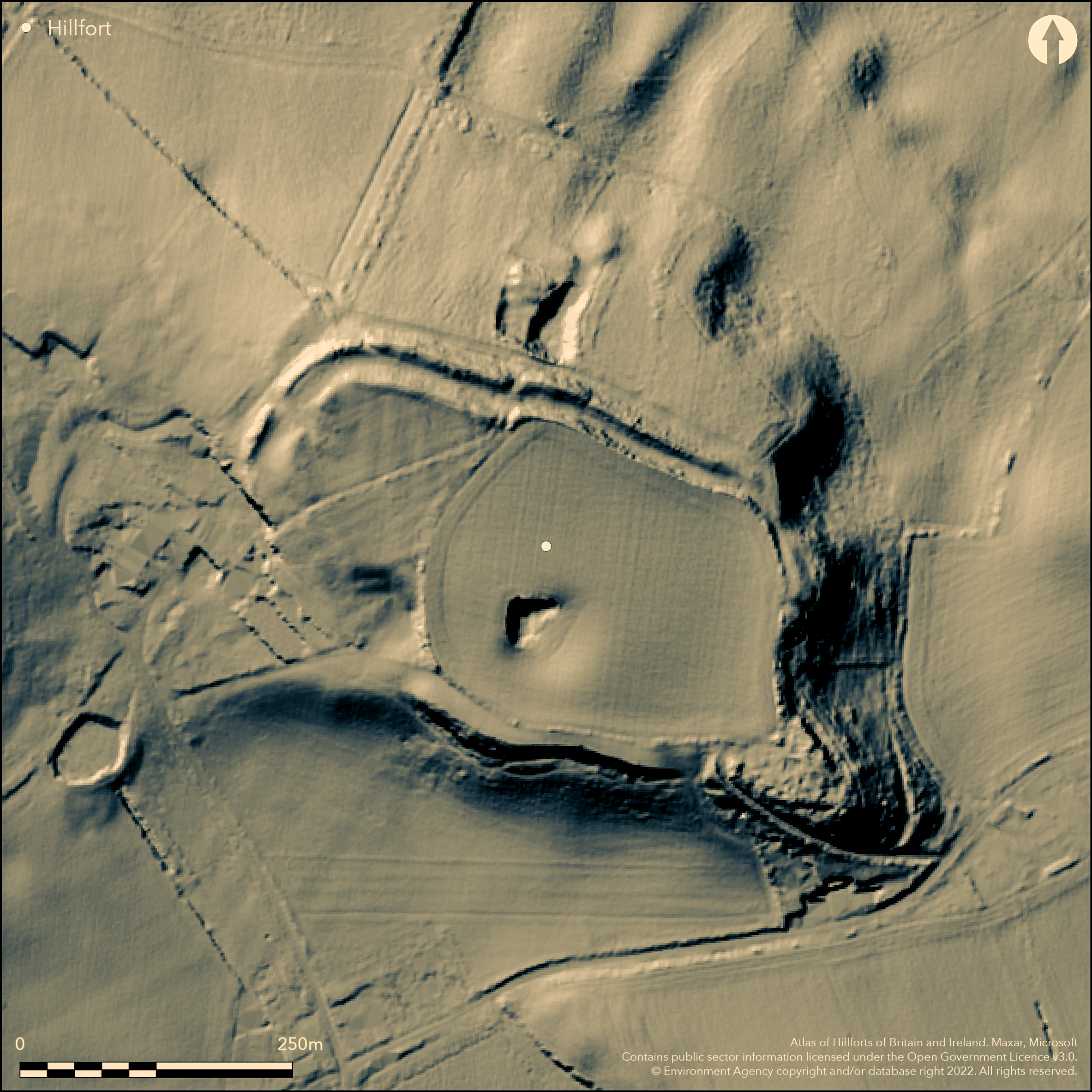
LiDAR 1m DTM Hillshade
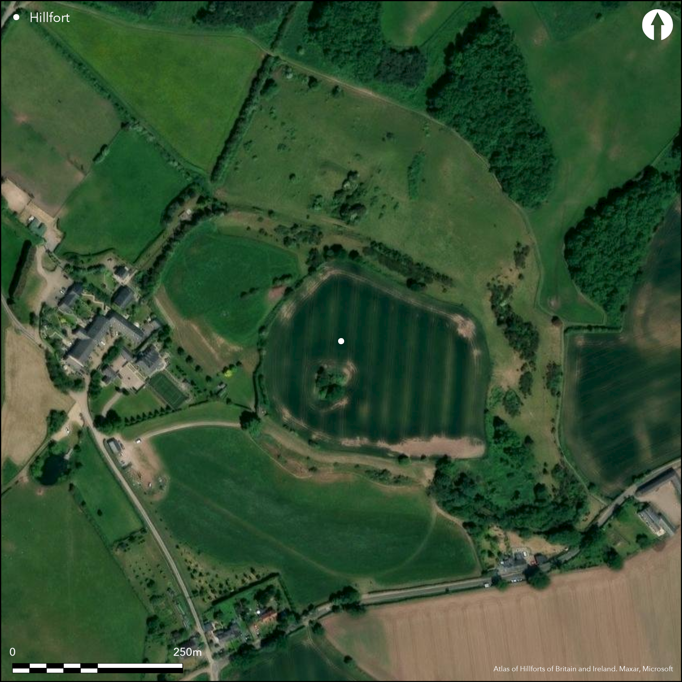
Satellite Imagery
LiDAR 1m DTM Hillshade
Satellite Imagery
Scroll left/right to view further images.
HER: Cheshire MCH8266 (866/1/3)
NMR: SJ 56 NE 2 (None)
SM: 1013295
NGR: SJ55326935
X: 355321 Y: 369359 (OSGB36)
Complex, bivallate, contour hillfort located on Eddisbury Hill, Delamere, a sandstone outcrop on E edge of Mid-Cheshire Ridge. Incorporates Merrick's Hill, Castle Ditch and Old Pale Farm. Moderate to strong surrounding slopes. Measures c. 380m NW-SE by 200m transversely overall, with area 7.6ha and internal area c. 3.5ha. Two ramparts with medial ditch surround hilltop, but damaged, ploughed and quarried away, especially on E, SW and NW. Best preserved on NE where still impressive. Inner rampart to 15m in width and 0.6m high internally and 4m high externally, with the medial ditch 10m wide and 0.5m deep. The outer bank, some 16m wide, is c. 2m high internally and to 5.5m high externally. No outer ditch is visible. Where damaged/lost ramparts reduced to just steep-faced scarps incorporating sandstone outcrops, especially on S and E. Excavations W.J. Varley 1935-38. Excavations and investigations by Liverpool University ongoing. Varley's interpretation of the site from his excavations much questioned, starting with Royal Commission's survey 1987, and especially his views on site development. Varley (1950) suggested early bivallate ramparts of clay on stone footing. Later stone revetted ramparts of rubble and sand core with timber-lacing. Inturned entrance at NW end and small, probably original, SE entrance cut through sandstone outcrop. Varley suggested original entrance timber revetted with wooden guard chamber to S of internal corridor, but overlain by later archaeology. Later the NW inturned entrance of timber constructed at bivallate Phase 3 stage. Any surface features in interior ploughed away. He suggested seven phases at the site from a palisaded enclosure before 250 BC to modern, with Phases 2 and 3 being the construction of the hillfort proper - univallate on E half of hill 200-100 BC and bivallate reconstruction and W extension AD 1-50. Roman destruction followed with Dark Age and Saxon re-occupation with Burh. Medieval building and field boundaries on SE. Investigated under the local authorities and partners Habitats and Hillforts Landscape Partnership Scheme 2007-2011, including excavation 2010, 2011 of selected parts of Varley's Area 2 work and junction between his original and extended hillfort and entrance area including guard chamber. From this, Varley's interpretation appears erroneous and whole hillftop enclosed at same time in early Iron Age, with C14 dates of barley grains of 770-410 BC. On 1st Ed. OS map (1875).
Citizen Science: ✗
Reliability of Data: Confirmed
Reliability of Interpretation: Confirmed
X: -297291 Y: 7023681 (EPSG: 3857)
Longitude: -2.6706139597070933 Latitude: 53.21938090084578 (EPSG:4326)
Country: England
Current County or Unitary Authority: Cheshire West and Chester
Historic County: Cheshire
Current Parish/Community/Council/Townland: Delamere
Ramparts damaged and lost to quarrying or ploughing, especially on E, SW and NW, and interior ploughed. Farm buildings intrude on W. Banks well-preserved in places, but any surface features in interior ploughed away. Multiple owners, including Forestry Commission. On Heritage at Risk Register (2015).
| Extant | ✓ |
| Cropmark | ✗ |
| Likely Destroyed | ✗ |
Part arable, part pasture interior. Scrub on banks.
| Woodland | ✗ |
| Commercial Forestry Plantation | ✗ |
| Parkland | ✗ |
| Pasture (Grazing) | ✓ |
| Arable | ✓ |
| Scrub/Bracken | ✓ |
| Bare Outcrop | ✗ |
| Heather/Moorland | ✗ |
| Heath | ✗ |
| Built-up | ✗ |
| Coastal Grassland | ✗ |
| Other | ✗ |
Bivallate contour hillfort located on Eddisbury Hill, Delamere, a sandstone outcrop on E edge of Mid-Cheshire Ridge. Moderate to strong surrounding slopes.
| Contour Fort | ✓ |
| Partial Contour Fort | ✗ |
| Promontory Fort | ✗ |
| Hillslope Fort | ✗ |
| Level Terrain Fort | ✗ |
| Marsh Fort | ✗ |
| Multiple Enclosure Fort | ✗ |
| Hilltop | ✓ |
| Coastal Promontory | ✗ |
| Inland Promontory | ✗ |
| Valley Bottom | ✗ |
| Knoll/Hillock/Outcrop | ✗ |
| Ridge | ✗ |
| Cliff/Plateau-edge/Scarp | ✗ |
| Hillslope | ✗ |
| Lowland | ✗ |
| Spur | ✗ |
Dominant Topographic Feature: Hill top
| North | ✗ |
| Northeast | ✗ |
| East | ✗ |
| Southeast | ✗ |
| South | ✗ |
| Southwest | ✗ |
| West | ✗ |
| Northwest | ✗ |
| Level | ✓ |
Altitude: 152.0m
N/A
Varley (1950) suggested seven phases at the site from a palisaded enclosure before 250 BC to modern, with Phases 2 and 3 being the construction of the hilfort proper - univallate on E half of hill 200-100 BC and bivallate reconstruction and W extension AD 1-50. Roman destruction followed with Dark Age and Saxon re-occupation. This has been much questioned and excavation 2010, 2011 found Varley's original and then later extended areas in fact enclosed at same time, with C14 dates of barley grains of 770-410 BC. Middle Iron Age C14 dates of 360-160 BC and 410-385 BC.
Reliability: B - Medium
| Pre 1200BC | ✗ |
| 1200BC - 800BC | ✗ |
| 800BC - 400BC | ✗ |
| 400BC - AD50 | ✓ |
| AD50 - AD400 | ✓ |
| AD400 - AD 800 | ✗ |
| Post AD800 | ✗ |
| Unknown | ✗ |
| Pre Hillfort: | None |
| Post Hillfort: | None |
| Artefactual: | None |
| C14: | C14 dates of barley grains of 770-410 BC and middle Iron Age C14 dates of 360-160 BC and 410-385 BC. |
On 1st Ed. OS map (1875). Defences described by George Ormerod in his 'History of Cheshire' 1882. Excavations W.J. Varley 1935-38. RCHME survey 1987, ref. no. 761685. Watching Brief Gifford and Partners 2006. Investigated under the local authorities and partners Habitats and Hillforts Landscape Partnership Scheme 2007-2011. Geophysics 2004 (South Trafford Arch. Group). LiDAR. Excavation and investigation Liverpool University.
| 1st Identified Map Depiction (1875): | OS map. |
| 1st Identified Written Reference (1882): | G. Ormerod 'History of Cheshire'. |
| Earthwork Survey (1987): | None |
| Geophysical Survey (2004): | None |
| Other (2006): | Watching Brief Gifford and Partners. |
| LiDAR Survey (2009): | None |
| Excavation (None): | W.J. Varley |
| Other (None): | Habitats and Hillforts Landscape Partnership Scheme. |
| Excavation (None): | Liverpool University. |
Possible quarry pits c. 5.5m wide by 1.8m deep. Any surface features in interior ploughed away. Habitats and Hillforts excavation found pit/hearth with charcoal of hazel, alder and birch. Early Bronze Age barbed and tanged arrowheads from interior field walking and decorated sandstone boulder from later excavations. No details of excavated pottery or finds of Varley's excavations, but Roman pottery and roof tiling found.
None
| None | ✓ |
| Spring | ✗ |
| Stream | ✗ |
| Pool | ✗ |
| Flush | ✗ |
| Well | ✗ |
| Other | ✗ |
None
| No Known Features | ✓ |
| Round Stone Structures | ✗ |
| Rectangular Stone Structures | ✗ |
| Curvilinear Platforms | ✗ |
| Other Roundhouse Evidence | ✗ |
| Pits | ✗ |
| Quarry Hollows | ✗ |
| Other | ✗ |
Possible quarry pits c. 5.5m wide by 1.8m deep.
| No Known Excavation | ✗ |
| Pits | ✗ |
| Postholes | ✗ |
| Roundhouses | ✗ |
| Rectangular Structures | ✗ |
| Roads/Tracks | ✗ |
| Quarry Hollows | ✓ |
| Other | ✗ |
| Nothing Found | ✗ |
None
| No Known Geophysics | ✓ |
| Pits | ✗ |
| Roundhouses | ✗ |
| Rectangular Structures | ✗ |
| Roads/Tracks | ✗ |
| Quarry Hollows | ✗ |
| Other | ✗ |
| Nothing Found | ✗ |
Roman pottery and roof tiling and possible later loom weight found. Habitats and Hillforts excavation found pit/hearth with charcoal of hazel, alder and birch. Early Bronze Age barbed and tanged arrowheads from interior field walking and decorated sandstone boulder from later excavations.
| No Known Finds | ✗ |
| Pottery | ✓ |
| Metal | ✗ |
| Metalworking | ✗ |
| Human Bones | ✗ |
| Animal Bones | ✗ |
| Lithics | ✓ |
| Environmental | ✓ |
| Other | ✓ |
None
| APs Not Checked | ✓ |
| None | ✗ |
| Roundhouses | ✗ |
| Rectangular Structures | ✗ |
| Pits | ✗ |
| Postholes | ✗ |
| Roads/Tracks | ✗ |
| Other | ✗ |
Inturned entrance at NW end and small, probably original, SE entrance cut through sandstone outcrop. Varley (1950) suggested original entrance timber revetted with wooden guard chamber to S of internal corridor, but overlain by later archaeology. Later the NW inturned entrance of timber constructed at bivallate Phase 3 stage with two stone-lined guard chambers replacing earlier single timber version. All this has been much questioned and 2010 excavation found constructed in one phase. There is a possibility of a blocked entrance to N.
| 2: | None |
| 2: | None |
Guard Chambers: ✓
Chevaux de Frise: ✗
| 1. In-turned (North west): | Various phases. |
| 2. Simple Gap (South east): | None |
Two ramparts with medial ditch surround hilltop, but damaged, ploughed and quarried away, especially on E, SW and NW. Best preserved on NE where still impressive. Inner rampart to 15m in width and 0.6m high internally and 4m high externally, with the medial ditch 10m wide and 0.5m deep. The outer bank, some 16m wide, is c. 2m high internally and to 5.5m high externally. No outer ditch is visible. Where damaged/lost defences reduced to just steep-faced scarps incorporating sandstone outcrops, especially on S and E. Varley suggested early bivallate ramparts of clay on stone footing. Later stone revetted rampart of rubble and sand core with timber-lacing. Postholes near guard chambers interpreted as timber bridge or walk way linking ends of ramparts over NW entrance.
| Area 1: | 3.5ha. |
| Total: | 3.5ha. |
Total Footprint Area: 7.6ha.
None
| ✓ | Varley (1950) suggested seven phases to the site from a palisaded enclosure before 250 BC to modern. |
| ✓ | None |
| NE Quadrant: | 2 |
| SE Quadrant: | 2 |
| SW Quadrant: | 2 |
| NW Quadrant: | 2 |
| Total: | 2 |
| Partial Univallate | ✗ |
| Univallate | ✗ |
| Partial Bivallate | ✗ |
| Bivallate | ✓ |
| Partial Multivallate | ✗ |
| Multivallate | ✗ |
| Unknown | ✗ |
| Partial Univallate | ✗ |
| Univallate | ✗ |
| Partial Bivallate | ✗ |
| Bivallate | ✗ |
| Partial Multivallate | ✗ |
| Multivallate | ✗ |
None
| None | ✗ |
| Earthen Bank | ✓ |
| Stone Wall | ✗ |
| Rubble | ✗ |
| Wall-walk | ✗ |
| Evidence of Timber | ✗ |
| Vitrification | ✗ |
| Other Burning | ✗ |
| Palisade | ✗ |
| Counter Scarp Bank | ✗ |
| Berm | ✗ |
| Unfinished | ✗ |
| Other | ✗ |
Varley suggested early bivallate ramparts of clay on stone footing. Later stone revetted rampart of rubble and sand core with timber-lacing. Postholes near guard chambers interpreted as timber bridge or walk way linking ends of ramparts over NW entrance.
| None | ✗ |
| Earthen Bank | ✓ |
| Stone Wall | ✓ |
| Murus Duplex | ✗ |
| Timber-framed | ✗ |
| Timber-laced | ✓ |
| Vitrification | ✗ |
| Other Burning | ✗ |
| Palisade | ✗ |
| Counter Scarp Bank | ✗ |
| Berm | ✗ |
| Unfinished | ✗ |
| No Known Excavation | ✗ |
| Other | ✗ |
| ✗ | Possible quarry pits c. 5.5m wide by 1.8m deep or compartments suggest gang working. |
| ✓ | Medial ditch, but no outer ditch visible. |
Number of Ditches: 1
| ✗ | None |
Cocroft, W.D, Everson, P., Jecock, M. and Wilson-North, W.R. 1989. Castle Ditch Hillfort, Eddisbury, Cheshire reconsidered,: the excavations of 1935-38 in the light of recent field survey, in eds M. Bowden, D. Mackay and P. Topping, From Cornwall to Caithness, some aspects of British field archaeology. Papers presented to Norman V. Quinell, BAR Brit Ser, 209, Oxford, 129-35.
Forde-Johnston, J. 1962. The Iron Age hill-forts of Lancashire and Cheshire, Trans Lancashire Cheshire Antiq Soc, 72, 9-46.
Garner, D. 2012. Hillforts of the Cheshire Sandstone Ridge, Monograph, Habitats and Hillforts Landscape Partnership Scheme, Chester: Cheshire West and Chester Council.
Garner, D. 2014. A tour of Eddisbury and its environs, In ed. Saunders, T., Hillforts in the North West and Beyond, Archaeological North West: New Series, 3 (2014), Council for British Archaeology North West, 73-85.
Garner, D. 2014. Helsby Hill to Maiden Castle: Prehistoric forts of the Cheshire Ridge, In ed. Saunders, T., Hillforts in the North West and Beyond, Archaeological North West: New Series, 3 (2014), Council for British Archaeology North West, 28-41.
Garner, D. 2016. Hillforts of the Cheshire Ridge. Investigations undertaken by the Habitats and Hillforts Landscape Partnership Scheme 2009-2012. Oxford: Archaeopress.
Longley, D.M. 1987. Prehistory, In eds B.E. Harris and A.T. Thacker, The Victoria History of the County of Chester, Vol 1, Oxford: Oxford University Press.
Ormerod, G. 1882. The History of Cheshire, 2nd Ed.
Varley, W.J. 1950. Excavations of the Castle Ditch, Eddisbury, 1935-38, Trans Hist Soc Lancashire Cheshire, 102, 1-68.
Webster, T. 2006. Archaeological Recording at Eddisbury Hillfort, Delamere, Cheshire, Report Gifford and Partners, Chester: Gifford and Partners.
Atlas of Hillforts:
Wikidata:
This work is licensed under CC BY-SA 4.0

 and should be cited as:
Lock, Gary and Ralston, Ian. 2024. Atlas of Hillforts of Britain and Ireland. Available at: https://hillforts.arch.ox.ac.uk
Document Version 1.1