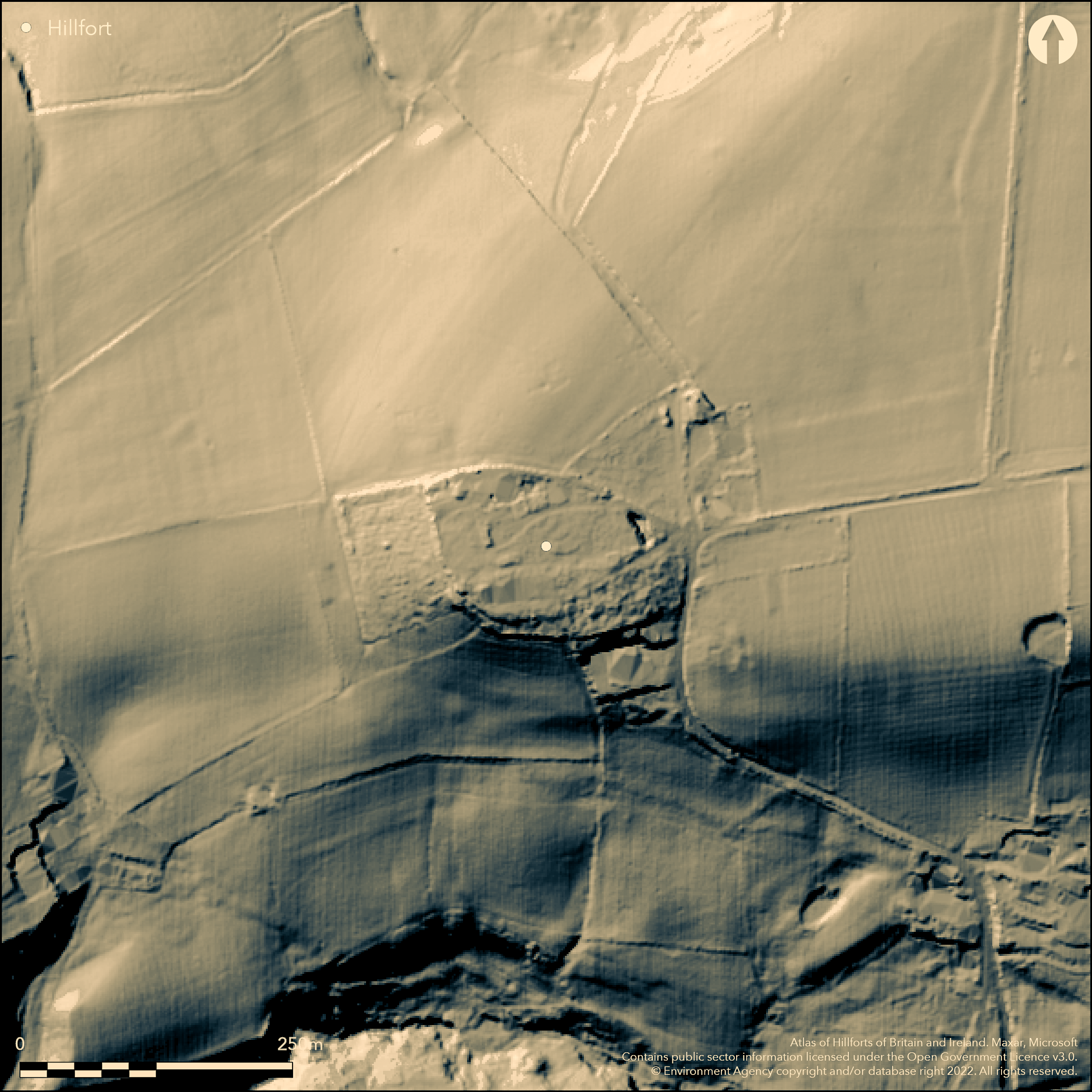
LiDAR 1m DTM Hillshade
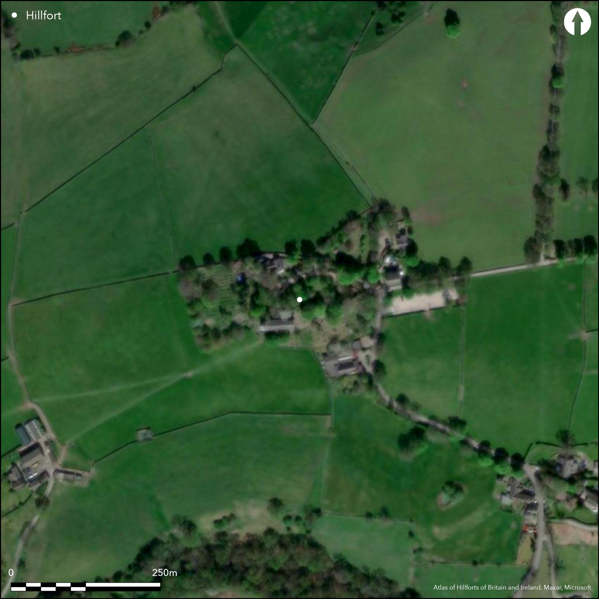
Satellite Imagery
LiDAR 1m DTM Hillshade
Satellite Imagery
Scroll left/right to view further images.
HER: Greater Manchester 11249 (None)
NMR: SJ 98 NE (None)
SM: None
NGR: SJ98208 88929
X: 398208 Y: 388929 (OSGB36)
Destroyed multiple enclosure hillfort located on hill top spur sited between two wooded stream valleys which meet River Goyt to W. Commands views to Alderley Edge and across Cheshire Plain and Mersey Basin to S and with far reaching views to Snowdonia foothills. Steep slopes to N, S and W. Enclosed area c. 2ha. Site first mentioned by Rev William Marriott in his 'Antiquities of Lyme' of 1810. Excavations in Old Vicarage garden and adjoining fields by Manchester University Archaeological Unit and Mellor Archaeological Trust (set up in 2000 to oversee investigations) 1998-2009. Site enclosed by single ditch, c. 1.5m-2.2m wide and c. 1.6m deep cut into sandstone bedrock. Second and deeper inner ditch, again cut into sandstone bedrock, c. 4m wide and c. 2.1m deep, with palisade 3.25m beyond inner edge of ditch and sited directly on edge of sharp break of slope. Ditch later re-filled and posthole inserted possibly for gate. No evidence of either ditch having associated bank. Postholes and re-cuts of arcing drainage gully representing eaves drip from roundhouse found. Gully, c. 0.4m wide and 0.3m deep, with roundhouse c. 11m diameter. Gully C14 date 520-380 cal BC and cut by curvilinear stone-lined gully producing two dates: earliest between 410 cal BC and 360 cal BC and later between 280 cal BC and 240 cal BC. Later gully had very regular vertical stone packing along both edges, possibly serving to brace wooden posts, fences or hurdles. Stone-lined gully unclear whether part of different design of house structure or stock enclosure. Substantial range of artefacts. Another date from charcoal from inner ditch 830 BC to 190 BC. Bronze Age amber necklace suggests high-status trade. Bronze Age flint dagger possibly suggests funerary practice. Large quantity of Iron Age pottery, VCP and potboilers and part horse harness. Re-constructed barrel-shaped pot of local Derbyshire manufacture - 'The Mellor Pot'. Slag, crucible sherds and mould - chemical analysis indicating late Bronze Age/early Iron Age bronze smelting on site. Romano pottery, brooches, nails, roof tile, glass and silver denarius (c. AD 78). Hillfort now covered by St Thomas' Church, Old and New Vicarages the Glebe Cottage and associated gardens and fields.
Citizen Science: ✗
Reliability of Data: Confirmed
Reliability of Interpretation: Confirmed
X: -225803 Y: 7056805 (EPSG: 3857)
Longitude: -2.0284209224360334 Latitude: 53.39717655812261 (EPSG:4326)
Country: England
Current County or Unitary Authority: Stockport
Historic County: Lancashire
Current Parish/Community/Council/Townland: Mellor
Hillfort now covered by St Thomas' Church, Old and New Vicarages the Glebe Cottage and assiciated gardens and fields. Replica roundhouse built by students of Ridge Danyers Sixth Form College 2002.
| Extant | ✗ |
| Cropmark | ✗ |
| Likely Destroyed | ✓ |
Built-up.
| Woodland | ✗ |
| Commercial Forestry Plantation | ✗ |
| Parkland | ✗ |
| Pasture (Grazing) | ✗ |
| Arable | ✗ |
| Scrub/Bracken | ✗ |
| Bare Outcrop | ✗ |
| Heather/Moorland | ✗ |
| Heath | ✗ |
| Built-up | ✓ |
| Coastal Grassland | ✗ |
| Other | ✗ |
Destroyed multiple enclosure hillfort located on hill top spur sited between two wooded stream valleys which meet River Goyt to W. Commands views to Alderley Edge and across Cheshire Plain and Mersey Basin to S and with far reaching views to Snowdonia foothills. Steep slopes to N, S and W.
| Contour Fort | ✗ |
| Partial Contour Fort | ✗ |
| Promontory Fort | ✗ |
| Hillslope Fort | ✗ |
| Level Terrain Fort | ✗ |
| Marsh Fort | ✗ |
| Multiple Enclosure Fort | ✓ |
| Hilltop | ✗ |
| Coastal Promontory | ✗ |
| Inland Promontory | ✗ |
| Valley Bottom | ✗ |
| Knoll/Hillock/Outcrop | ✗ |
| Ridge | ✗ |
| Cliff/Plateau-edge/Scarp | ✗ |
| Hillslope | ✗ |
| Lowland | ✗ |
| Spur | ✓ |
Dominant Topographic Feature: Spur
| North | ✗ |
| Northeast | ✗ |
| East | ✗ |
| Southeast | ✗ |
| South | ✗ |
| Southwest | ✗ |
| West | ✗ |
| Northwest | ✗ |
| Level | ✓ |
Altitude: 220.0m
N/A
Site c. 900BC-200BC, with later re-occupation in Roman period c. AD 180. Bronze Age amber necklace and Bronze Age flint dagger. Large quantity of iron Age pottery and potboilers and part horse harness. Re-constructed barrel-shaped pot of local Derbyshire manufacture - 'The Mellor Pot'. Slag, crucible sherds and mould - chemical analysis indicating late Bronze Age/early Iron Age bronze smelting on site. Roman pottery, brooches, nails, roof tile, glass and silver denarius (c. AD 78). Gully prouced C14 date 520-380 cal BC and cut by curvilinear stone-lined gully producing two dates: earliest between 410 cal BC and 360 cal BC and later between 280 cal BC and 240 cal BC. Another date from charcoal from inner ditch 830 BC to 190 BC.
Reliability: A - High
| Pre 1200BC | ✗ |
| 1200BC - 800BC | ✓ |
| 800BC - 400BC | ✓ |
| 400BC - AD50 | ✓ |
| AD50 - AD400 | ✓ |
| AD400 - AD 800 | ✗ |
| Post AD800 | ✗ |
| Unknown | ✗ |
| Pre Hillfort: | None |
| Post Hillfort: | None |
| Artefactual: | Pottery and many other artefacts. |
| C14: | C14 dates from roundhouse features produced dates between 520BC and 380BC, 410BC and 360BC and 280BC and 240BC. Another date from charcoal from inner ditch 830 BC to 190 BC. |
| Morphology/Earthwork/Typology: | General features. |
Site first mentioned by Rev William Marriott in his 'Antiquities of Lyme' of 1810. Parch marks noted in gardens and surrounding fields in summer of 1995 by J. and A. Hearle. Excavation by Manchester University Archaeological Unit and Mellor Archaeological Trust (set up in 2000 to oversee investigations) 1998-2009. Project support Heritage Lottery Fund, Stockport Council and the Friends of the Trust.
| 1st Identified Written Reference (1810): | Site first mentioned by Rev William Marriott in his 'Antiquities of Lyme' |
| Other (1995): | Parch marks noted by J. and A. Hearle. |
| Geophysical Survey (1998): | Resistivity survey Manchester University Archaeological Unit. |
| Excavation (None): | Manchester University Archaeological Unit and Mellor Archaeological Trust.. |
Details of roundhouse and its associated drainage gully found within inner enclosure. Initial geophysics used to determine extent of site and located E and N sections of outer ditch. Large quantity of Iron Age pottery and potboilers and part horse harness. Re-constructed barrel-shaped pot of local Derbyshire manufacture - 'The Mellor Pot'. Slag, crucible sherds and mould - chemical analysis indicating late Bronze Age/early Iron Age bronze smelting on site. Bronze Age amber necklace suggests high-status trade. Bronze Age flint dagger possibly suggests funerary practice. Romano-British pottery, roof tile, glass and silver denarius (c. AD 78). Medieval vessel and jewellery.
None
| None | ✓ |
| Spring | ✗ |
| Stream | ✗ |
| Pool | ✗ |
| Flush | ✗ |
| Well | ✗ |
| Other | ✗ |
Site built upon.
| No Known Features | ✓ |
| Round Stone Structures | ✗ |
| Rectangular Stone Structures | ✗ |
| Curvilinear Platforms | ✗ |
| Other Roundhouse Evidence | ✗ |
| Pits | ✗ |
| Quarry Hollows | ✗ |
| Other | ✗ |
Re-cuts found of drainage gully c. 0.4m wide and 0.3m deep associated roundhouse c. 11m diameter. Possible S entrance. Gully cut by curvilinear stone-lined gully which had very regular vertical stone packing along both edges, possibly serving to brace wooden posts, fences or hurdles. Stone-lined gully unclear whether part of different design of house structure or stock enclosure.
| No Known Excavation | ✗ |
| Pits | ✗ |
| Postholes | ✓ |
| Roundhouses | ✓ |
| Rectangular Structures | ✗ |
| Roads/Tracks | ✗ |
| Quarry Hollows | ✗ |
| Other | ✓ |
| Nothing Found | ✗ |
Initial geophysics used to determine extent of site and located E and N sections of outer ditch.
| No Known Geophysics | ✗ |
| Pits | ✗ |
| Roundhouses | ✗ |
| Rectangular Structures | ✗ |
| Roads/Tracks | ✗ |
| Quarry Hollows | ✗ |
| Other | ✓ |
| Nothing Found | ✗ |
Large quantity of Iron Age pottery, VCP and potboilers and part horse harness. Re-constructed barrel-shaped pot of local Derbyshire manufacture - 'The Mellor Pot'. Slag, crucible sherds and mould - chemical analysis indicating late Bronze Age/early Iron Age bronze smelting on site. Bronze Age amber necklace found 2008 suggests high-status trade. Bronze Age flint dagger possibly suggests funerary practice. Romano-British pottery, roof tile, glass and silver denarius (c. AD 78). Medieval vessel and jewellery.
| No Known Finds | ✗ |
| Pottery | ✓ |
| Metal | ✓ |
| Metalworking | ✓ |
| Human Bones | ✗ |
| Animal Bones | ✗ |
| Lithics | ✓ |
| Environmental | ✗ |
| Other | ✓ |
None
| APs Not Checked | ✓ |
| None | ✗ |
| Roundhouses | ✗ |
| Rectangular Structures | ✗ |
| Pits | ✗ |
| Postholes | ✗ |
| Roads/Tracks | ✗ |
| Other | ✗ |
Inner ditch later re-filled and posthole inserted possibly for gate - no further details.
| 0: | None |
| 2: | None |
Guard Chambers: ✗
Chevaux de Frise: ✗
No evidence of either ditch having associated bank. Site enclosed by single ditch, c. 1.5m-2.2m wide and c. 1.6m deep cut into sandstone bedrock. Second and deeper inner ditch, again cut into sandstone bedrock, c. 4m wide and c. 2.1m deep, with palisade 3.25m beyond inner edge of ditch and sited directly on edge of sharp break of slope. This ditch later re-filled.
| Area 1: | 2.0ha. |
| Total: | 2.0ha. |
Total Footprint Area: Noneha.
None
| ✗ | Area estimated. |
| ✗ | Site built upon and destroyed. No details. |
| NE Quadrant: | None |
| SE Quadrant: | None |
| SW Quadrant: | None |
| NW Quadrant: | None |
| Total: | None |
| Partial Univallate | ✗ |
| Univallate | ✗ |
| Partial Bivallate | ✗ |
| Bivallate | ✗ |
| Partial Multivallate | ✗ |
| Multivallate | ✗ |
| Unknown | ✓ |
| Partial Univallate | ✗ |
| Univallate | ✗ |
| Partial Bivallate | ✗ |
| Bivallate | ✗ |
| Partial Multivallate | ✗ |
| Multivallate | ✗ |
Site built upon.
| None | ✓ |
| Earthen Bank | ✗ |
| Stone Wall | ✗ |
| Rubble | ✗ |
| Wall-walk | ✗ |
| Evidence of Timber | ✗ |
| Vitrification | ✗ |
| Other Burning | ✗ |
| Palisade | ✗ |
| Counter Scarp Bank | ✗ |
| Berm | ✗ |
| Unfinished | ✗ |
| Other | ✗ |
Details of of inner and outer ditches. No evidence of either ditch having associated bank. Inner ditch had associated palisade.
| None | ✗ |
| Earthen Bank | ✗ |
| Stone Wall | ✗ |
| Murus Duplex | ✗ |
| Timber-framed | ✗ |
| Timber-laced | ✗ |
| Vitrification | ✗ |
| Other Burning | ✗ |
| Palisade | ✓ |
| Counter Scarp Bank | ✗ |
| Berm | ✗ |
| Unfinished | ✗ |
| No Known Excavation | ✗ |
| Other | ✓ |
| ✗ | None |
| ✓ | Inner and outer ditches cut into sandstone bedrock. |
Number of Ditches: 2
| ✗ | None |
Forde-Johnston, James (1962), The Iron Age Hillforts of Lancashire and Cheshire, Trans Lancashire Cheshire Antiq Soc, 72, 9-46.
Hearle, J., Nevell, M. and Thompson, A. 2014. Mellor: Late Bronze Age to late Roman settlement activity in an upland context, In ed. Saunders, T., Hillforts in the North West and Beyond, Archaeological North West: New Series, 3 (2014), Council for British Archaeology North West, 65-72.
Hodgson, J. and Brennand, M. 2006. The Prehistoric Period Resource Assessment, Archaeol North West, 8, 23-58.
Marriott, Rev W. 1810. Antiquities of Lyme and its Vicinity, Stockport: J. Dawson.
Morgan, V. and Morgan, P. 2004, Prehistoric Cheshire, Landmark Collector's Library, Ashbourne: Landmark Publishing, 153-54.
Nevell, M. and Redhead, N. (eds) 2005. Mellor: Living on the Edge. A Regional Study of an Iron Age and Romano-British Upland Settlement, Manchester: University of Manchester Archaeological Unit, Greater Manchester Archaeological Unit, and the Mellor Archaeological Trust.
Philpott, R. 2006. The Romano-British Period Resource Assessment, Archaeol North West, 8, 59-90.
University of Manchester Archaeological Unit 2000. Excavations at Mellor, Stockport. Second Season. UMAU Monograph, Manchester.
University of Manchester Archaeological Unit 2005. Mellor: Living on the Edge, UMAU Monograph, Manchester.
Atlas of Hillforts:
Wikidata:
This work is licensed under CC BY-SA 4.0

 and should be cited as:
Lock, Gary and Ralston, Ian. 2024. Atlas of Hillforts of Britain and Ireland. Available at: https://hillforts.arch.ox.ac.uk
Document Version 1.1