LiDAR 1m DTM Hillshade
Satellite Imagery
LiDAR 1m DTM Hillshade
Satellite Imagery
Scroll left/right to view further images.
HER: Greater Manchester 78.1.0 (None)
NMR: SD 71 SE (None)
SM: 1014720
NGR: SD7970 1298
X: 379700 Y: 412980 (OSGB36)
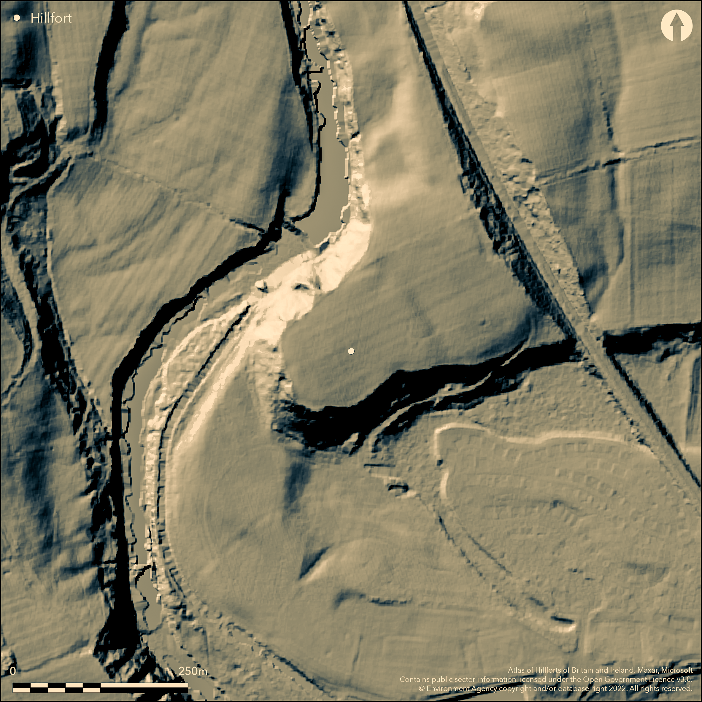
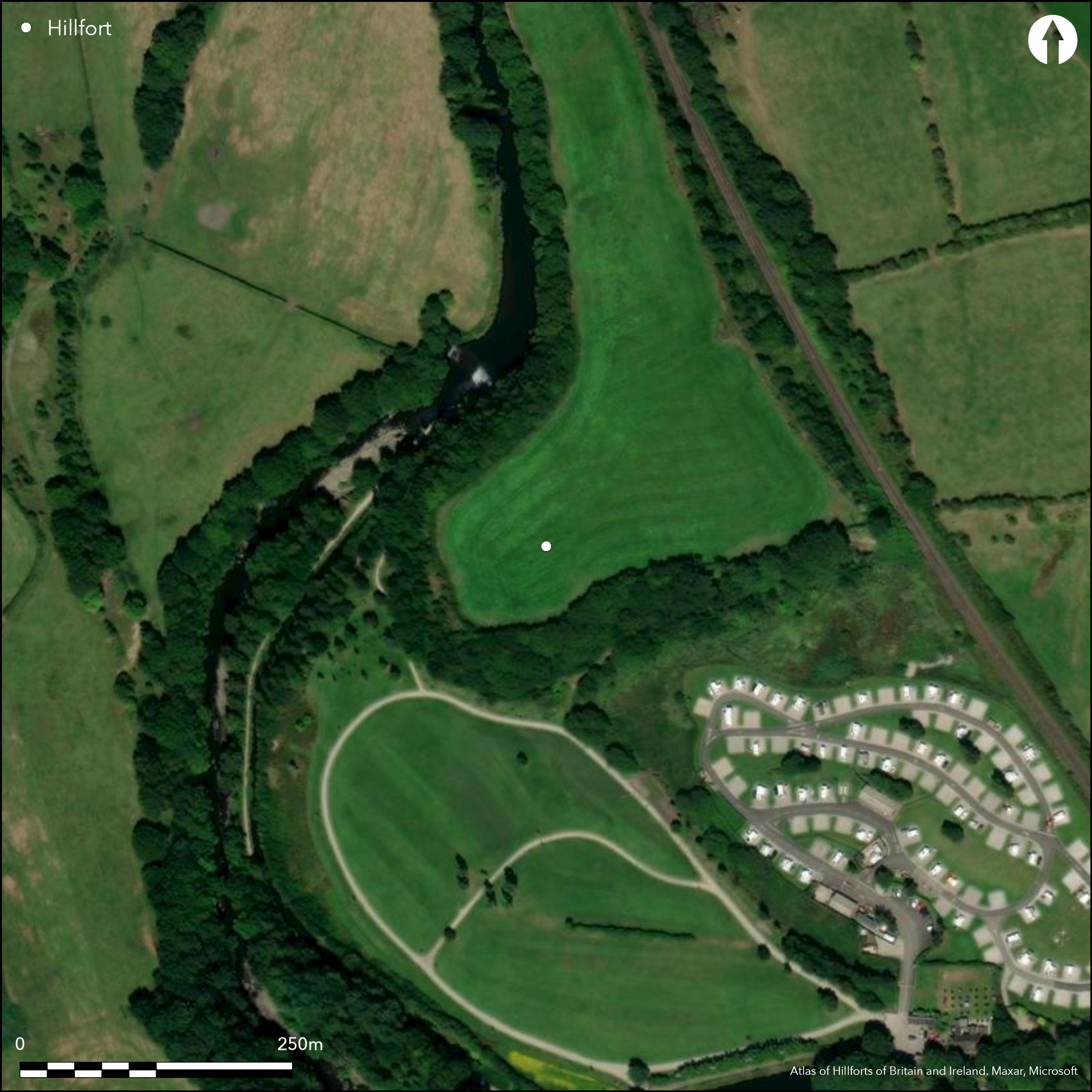
Inland promontory fort located in commanding position on prominent SW-facing spur above bends and floodplain of the River Irwell. Moderate slope along spur to NE, steep slopes elsewhere. Enclosed area c.1ha. Promontory cut off by N-S ditch 6m wide 120m LONG WITH the steep scarp at both ends. Interior triangular plateau with N side 100m long and S side 140m long. These two sides are defined by steep NATURAL slope of scarp falling away to the river bank on N side. On S side silted former channel of the Irwell. At NE corner rampart has been constructed to continue along the top of the steep scarp on N side. This continues PAST THE DITCH AND INTO FIELD TO E FOR 20M. Excavations by Bury Archaeological Group 1960's and 1984-86. THE Large ditch, TO 0.5M DEEP, cutting off promontory and silt-filled hollow way revealed by geophysical survey and excavation with possible hut sites, gullies, pits and domestic activity in interior. Associated with these LATE Iron Age pottery, sherds of undecorated Coarse Ware SUGGESTING mid fifth century BC to mid second century AD OCCUPATION. C14 produced earliest date range of 550 to 350 cal BC and a latest range of 47 to 247 cal AD. RIDGE AND FURROW ON SITE UNDER IMPROVED PASTURE. MUCH PLOUGH TRUNCATED, BUT WELL-PRESERVED. On a natural promontory overlooking the River Irwell was the former defended site at Castle Steads. A fortification is mentioned there as far back as 1751 when Thomas Percival reported a Roman camp above the River Irwell and John Aitkin in 1795 commented _Castle Steads in Walmersley, placed in a bend of the Irwell, is said to have been only an entrenchment of the Parliaments armyÓ (1, 2, 4 & 8). Clearly the promontory had a martial tradition. The location is situated in an excellent defensive position; the promontory is defined to the north, west & south by steep scarps. When trial trenching by the Bury Archaeological Group in the early 1960s was undertaken, nothing was revealed of a defensive nature; only shallow ploughsoil overlying natural clay and gravel (5). More extensive fieldwork was carried out by the group between 1984 & 1986, including an electrical resitivity, soil-auger and earthwork survey. A large ditch cutting off the promontory and a silt-filled hollow way was revealed. The interpretation of the ditch was one defence, possibly a small late prehistoric univallate hillfort which enclosed an area of 1 hectare (3). This seemed typical of a late Iron Age to Early Roman ditched enclosure (8, 9). A geophysical survey undertaken by North West Archaeological Services on behalf of Bury M.B.C Department of Development Services in 1991 revealed that the site was defined by a single ditch which cut off the promontory. Several responses of archaeological potential from the interior was suggestive of pits and domestic activity (9). The trial trenching produced a ditch and terminal that was 5m x 8m but only 0.5m deep due to later plough truncation. Negative features relating to probable house sites, gullies, pits and postholes were located in the interior of the enclosure (8). Associated with these features was late Iron Age pottery, sherds of undecorated Coarse Ware, pointing to an occupation period of the mid 5th century BC to the mid 2nd century AD. Radiocarbon dating produced an earliest date range of 550 to 350 cal BC and a latest range of 47 to 247 cal AD. Pollen analysis tentatively suggested that higher grounds surrounding Castle Steads could have carried open woodland alternating with areas of grassland capable of supporting pastoral farming activity with modest evidence for arable activity in the area (8). Other enclosure sites which may have belonged to the Iron Age have been identified along the Irwell, and around 23 from Cheshire, Greater Manchester and Merseyside (9). It seems likely that this landscape was extensively settled at this time. Despite the limited excavations of 1991 (only 2% of the total site) and later plough damage to the surviving evidence (ridge and furrow is found on and around the site), six of the seven trenches produced significant archaeological features. A high group value has been assigned to the site as it is one of a number of sites of very different periods in close proximity. This site also has high condition, potential and importance values; moderate to high rarity; moderate diversity and low threat, vulnerability and fragility values (7). The site is classified Grade 3 agricultural land and is presently tenant farmed as permanent grassland for dairying (11 The promontory fort at Castlesteads is well preserved in spite of the truncation of the central features by ploughing. The ditch and additional rampart on the north eastern corner are clearly visible. The interior of the settlement has been evaluated and this has shown that extensive remains of the dwellings and pits for storage and waste disposal remain in the central area. The fill of the ditch will contain important evidence of the construction and later settlement of the site. History Legacy Record - This information may be included in the List Entry Details. Details The monument includes a defended settlement on a natural promontory overlooking the floodplain of the River Irwell, 550m SSE of Banks Farm. The nose of the promontory is cut off by a ditch 6m wide running from north to south for 120m and meeting the edge of the steep scarp at both ends. The interior of the fort is a triangular plateau with its northern side 100m long and the southern side 140m long. The defences of these two sides are formed by the steep slope of the natural scarp falling away to the river bank on the north side. On the south side there is the silted former channel of the Irwell which would have further defended the site in the past. At the north east corner a rampart has been constructed to continue the defence of the top of the steep scarp on the northern side. This continues _zMonFullRpt Report generated by HBSMR from exeGesIS SDM Ltd Page 2 Greater Manchester Archaeological Advisory Service Monument Full Report SMR Number 78.1.0 Site Name Prehistoric Enclosed Settlement (site of), Castle Steads past the ditch, which interrupts it, and into the field to the east of the monument for 20m. An evaluation of the site in 1982 confirmed that the ditch is 0.5m deep and that the interior contains extensive remains of pits and the post holes of former buildings in the central area. No more than 2% of the site was excavated. Pottery and dated radio-carbon samples from the site show that it was occupied for a period from c.200 BC to AD 250. The post and wire fencing at the edges of the site are not included in the scheduling, although the ground beneath is included.
Citizen Science: ✗
Reliability of Data: Confirmed
Reliability of Interpretation: Confirmed
X: -256962 Y: 7097195 (EPSG: 3857)
Longitude: -2.308326335027825 Latitude: 53.61296723909039 (EPSG:4326)
Country: England
Current County or Unitary Authority: Bury
Historic County: Lancashire
Current Parish/Community/Council/Townland: Walmsley-with Shuttleworth
MUCH PLOUGH TRUNCATED, BUT WELL-PRESERVED.
| Extant | ✓ |
| Cropmark | ✗ |
| Likely Destroyed | ✗ |
RIDGE AND FURROW ON SITE UNDER IMPROVED PASTURE.
| Woodland | ✗ |
| Commercial Forestry Plantation | ✗ |
| Parkland | ✗ |
| Pasture (Grazing) | ✓ |
| Arable | ✗ |
| Scrub/Bracken | ✗ |
| Bare Outcrop | ✗ |
| Heather/Moorland | ✗ |
| Heath | ✗ |
| Built-up | ✗ |
| Coastal Grassland | ✗ |
| Other | ✗ |
Inland promontory fort located in commanding position on prominent SW-facing spur above bends and floodplain of the River Irwell. Moderate slope along spur to NE, steep slopes elsewhere.
| Contour Fort | ✗ |
| Partial Contour Fort | ✗ |
| Promontory Fort | ✓ |
| Hillslope Fort | ✗ |
| Level Terrain Fort | ✗ |
| Marsh Fort | ✗ |
| Multiple Enclosure Fort | ✗ |
| Hilltop | ✗ |
| Coastal Promontory | ✗ |
| Inland Promontory | ✓ |
| Valley Bottom | ✗ |
| Knoll/Hillock/Outcrop | ✗ |
| Ridge | ✗ |
| Cliff/Plateau-edge/Scarp | ✗ |
| Hillslope | ✗ |
| Lowland | ✗ |
| Spur | ✓ |
Dominant Topographic Feature: Spur
| North | ✗ |
| Northeast | ✗ |
| East | ✗ |
| Southeast | ✗ |
| South | ✗ |
| Southwest | ✓ |
| West | ✗ |
| Northwest | ✗ |
| Level | ✗ |
Altitude: 111.8m
N/A
LATE Iron Age pottery, sherds of undecorated Coarse Ware SUGGESTING c. mid fifth century BC to mid second century AD OCCUPATION. C14 produced earliest date range of 550 to 350 cal BC and a latest range of 47 to 247 cal AD.
Reliability: B - Medium
| Pre 1200BC | ✗ |
| 1200BC - 800BC | ✗ |
| 800BC - 400BC | ✗ |
| 400BC - AD50 | ✓ |
| AD50 - AD400 | ✗ |
| AD400 - AD 800 | ✗ |
| Post AD800 | ✗ |
| Unknown | ✗ |
| Pre Hillfort: | None |
| Post Hillfort: | None |
| Artefactual: | LATE IRON Age pottery. |
| C14: | Earliest date range of 550 to 350 cal BC and a latest range of 47 to 247 cal AD. |
Thomas Percival reported Roman camp above the River Irwell in 1751. John Aitkin in 1795 commented _Castle Steads in Walmersley, placed in a bend of the Irwell, is said to have been only an entrenchment of the Parliaments army in 1795. Trial trenching 1960's Bury Archaeological Group and further excavation 1984-86 and earthwork, auger and resistivity surveys. Geophysical survey by North West Archaeological Services on behalf of Bury M.B.C 1991. Field survey and evaluation, M. Fletcher 1991-92.
| 1st Identified Written Reference (1751): | Thomas Percival mention of site. |
| Other (1795): | John Aitkin mention of 'entrenchment'. |
| Geophysical Survey (1991): | North West Archaeological Services for Bury M.B.C. |
| Excavation (None): | Bury Archaeological Group. |
| Geophysical Survey (None): | Bury Archaeological Group. |
| Earthwork Survey (None): | Bury Archaeological Group. |
| Other (None): | Field survey and evaluation, M Fletcher. |
Possible pits and domestic activity in interior. Also probable house sites, gullies and postholes. Late Iron Age pottery sherd. Bowl c. 100-90 BC.
None
| None | ✓ |
| Spring | ✗ |
| Stream | ✗ |
| Pool | ✗ |
| Flush | ✗ |
| Well | ✗ |
| Other | ✗ |
None
| No Known Features | ✓ |
| Round Stone Structures | ✗ |
| Rectangular Stone Structures | ✗ |
| Curvilinear Platforms | ✗ |
| Other Roundhouse Evidence | ✗ |
| Pits | ✗ |
| Quarry Hollows | ✗ |
| Other | ✗ |
No information.
| No Known Excavation | ✗ |
| Pits | ✓ |
| Postholes | ✗ |
| Roundhouses | ✓ |
| Rectangular Structures | ✗ |
| Roads/Tracks | ✗ |
| Quarry Hollows | ✗ |
| Other | ✗ |
| Nothing Found | ✗ |
Possible pits and domestic activity in interior. Also probable house sites, gullies and postholes.
| No Known Geophysics | ✗ |
| Pits | ✓ |
| Roundhouses | ✓ |
| Rectangular Structures | ✗ |
| Roads/Tracks | ✗ |
| Quarry Hollows | ✗ |
| Other | ✓ |
| Nothing Found | ✗ |
Late Iron Age pottery sherd. Bowl c. 100-90 BC.
| No Known Finds | ✗ |
| Pottery | ✓ |
| Metal | ✗ |
| Metalworking | ✗ |
| Human Bones | ✗ |
| Animal Bones | ✗ |
| Lithics | ✗ |
| Environmental | ✗ |
| Other | ✗ |
None
| APs Not Checked | ✓ |
| None | ✗ |
| Roundhouses | ✗ |
| Rectangular Structures | ✗ |
| Pits | ✗ |
| Postholes | ✗ |
| Roads/Tracks | ✗ |
| Other | ✗ |
NONE DEFINED, BUT HOLLOW WAY FOUND IN EXCAVATIONS.
| 0: | None |
| 2: | None |
Guard Chambers: ✗
Chevaux de Frise: ✗
Promontory cut off by N-S ditch 6m wide 120m LONG WITH the steep scarp at both ends. Interior triangular plateau with N side 100m long and S side 140m long. Defences of these two sides are formed by steep NATURAL slope of scarp falling away to the river bank on N side. NE corner rampart has been constructed to continue the defence of top of the steep scarp on N side. This continues PAST THE DITCH AND INTO FIELD TO E FOR 20M. Ditch and additional rampart on NE corner clearly visible.
| Area 1: | 1.0ha. |
| Total: | 1.0ha. |
Total Footprint Area: Noneha.
None
| ✗ | None |
| ✗ | None |
| NE Quadrant: | 1 |
| SE Quadrant: | 1 |
| SW Quadrant: | 0 |
| NW Quadrant: | 0 |
| Total: | 1 |
| Partial Univallate | ✓ |
| Univallate | ✗ |
| Partial Bivallate | ✗ |
| Bivallate | ✗ |
| Partial Multivallate | ✗ |
| Multivallate | ✗ |
| Unknown | ✗ |
| Partial Univallate | ✗ |
| Univallate | ✗ |
| Partial Bivallate | ✗ |
| Bivallate | ✗ |
| Partial Multivallate | ✗ |
| Multivallate | ✗ |
Ditch and additional rampart on NE corner clearly visible.
| None | ✗ |
| Earthen Bank | ✓ |
| Stone Wall | ✗ |
| Rubble | ✗ |
| Wall-walk | ✗ |
| Evidence of Timber | ✗ |
| Vitrification | ✗ |
| Other Burning | ✗ |
| Palisade | ✗ |
| Counter Scarp Bank | ✗ |
| Berm | ✗ |
| Unfinished | ✗ |
| Other | ✗ |
EXCAVATION REVEALED DITCH DETAILS.
| None | ✗ |
| Earthen Bank | ✗ |
| Stone Wall | ✗ |
| Murus Duplex | ✗ |
| Timber-framed | ✗ |
| Timber-laced | ✗ |
| Vitrification | ✗ |
| Other Burning | ✗ |
| Palisade | ✗ |
| Counter Scarp Bank | ✗ |
| Berm | ✗ |
| Unfinished | ✗ |
| No Known Excavation | ✗ |
| Other | ✓ |
| ✗ | None |
| ✓ | DITCH C. 0.5M DEEP. |
Number of Ditches: 1
| ✗ | None |
Bury Archaeological Group 1960's. 1960's excavations at Castle Steads, Unpublished document.
Farrer, W. and Brownbill, J. (eds) 1908. Victoria County History of the County of Lancashire, Vol II, 553-54.
Fletcher, M. 1992. Castle Steads, Bury: Evaluation Report, Unpublished document.
Atlas of Hillforts:
Wikidata:
This work is licensed under CC BY-SA 4.0![]()
![]()
![]() and should be cited as:
and should be cited as:
Lock, Gary and Ralston, Ian. 2024. Atlas of Hillforts of Britain and Ireland. Available at: https://hillforts.arch.ox.ac.uk
Document Version 1.1