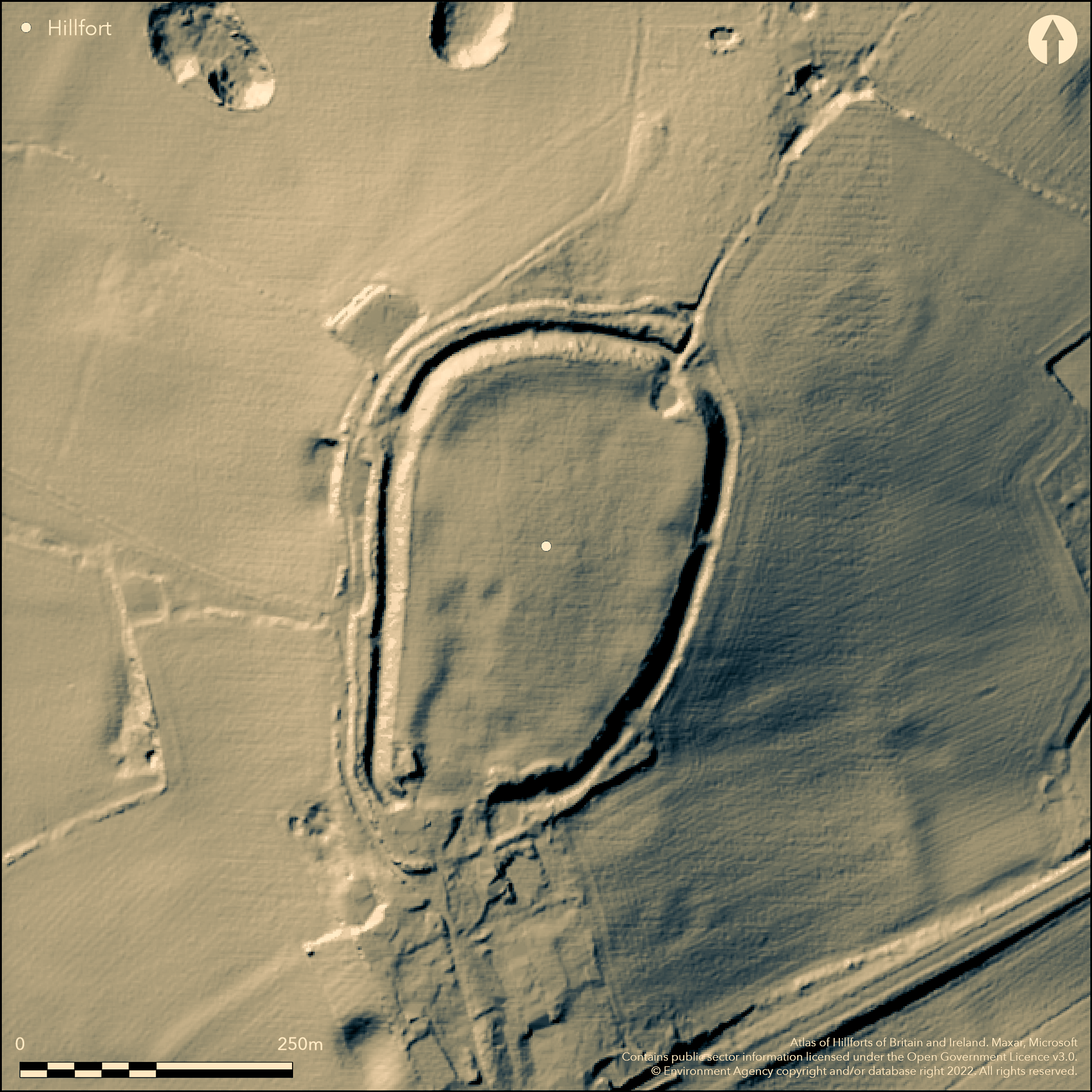
LiDAR 1m DTM Hillshade
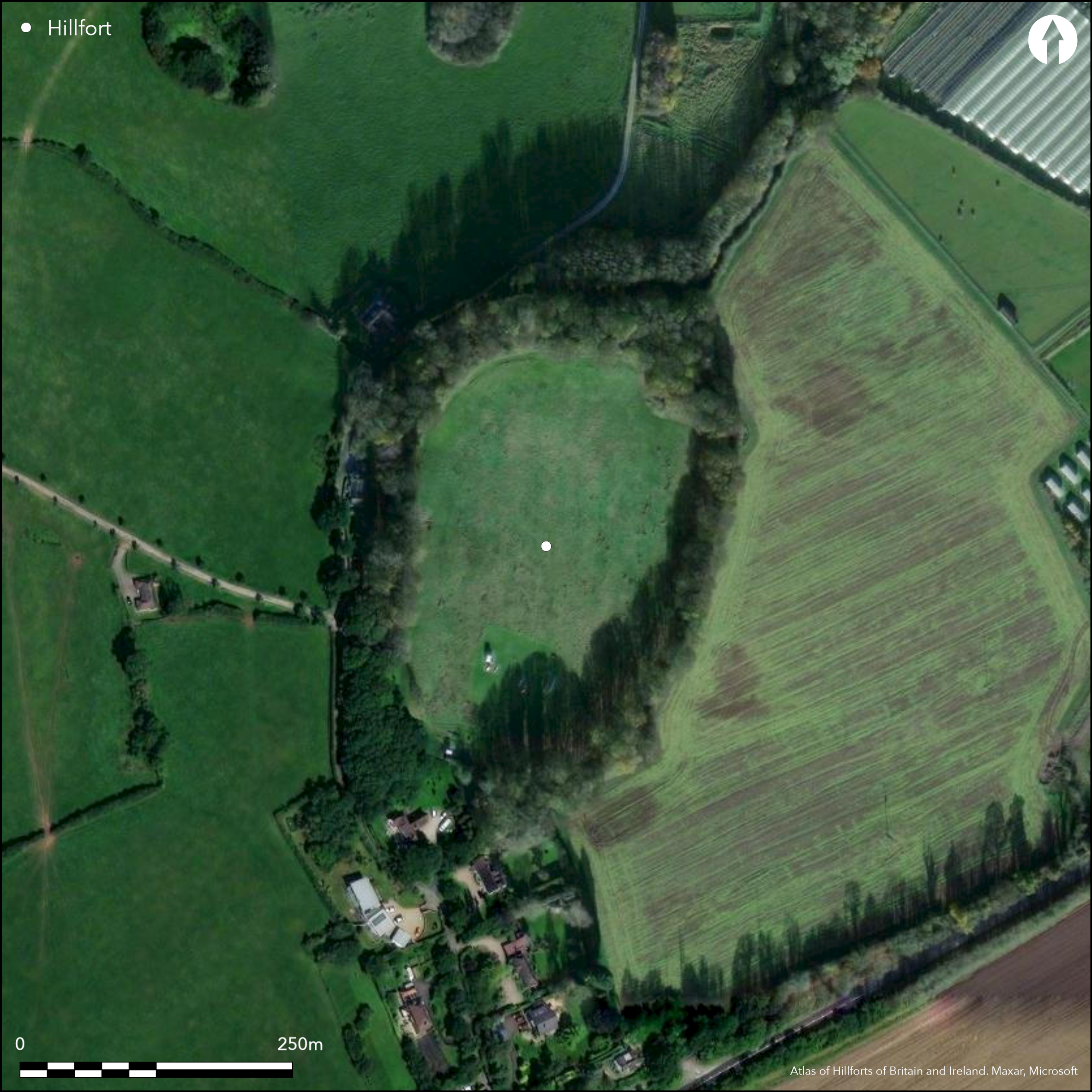
Satellite Imagery
LiDAR 1m DTM Hillshade
Satellite Imagery
Scroll left/right to view further images.
HER: Staffordshire 00024-MST24 (None)
NMR: SJ 82 SE 1 (75541)
SM: 1013163
NGR: SJ 88742 21175
X: 388742 Y: 321175 (OSGB36)
Lying at 140m OD on the northern end of an elevated spur to the N of Billington village, a univallate hillfort damaged through quarrying and extraction. Oval in form it measures approximately 280 SW-NE by 174m transversely enclosing 3.2ha. It comprises a bank and steep-sided ditch with an intermittent counterscarp which is absent in the E and destroyed by a cottage and landscaping in the W. A 43m length of rampart in the SE corner stands 1.5m high but elsewhere survives only to 0.2m. A low bank along the lip of the inner ditch has the appearance of a further rampart but could have been caused by using the inner circuit as a farm track (Cocroft et al. 1989). The ditch is 18m wide and between 4-4.7m deep. In the NW the counterscarp is 14m wide and 1m high. The original entrance lies in the S at the neck of the spur. Marl, sand and gravel extraction has caused damage to the SW corner of the ramparts which continues into the interior. Internally the ground is undulating with no visible internal features contemporary with the enclosure. A small spring-fed pond lies in the NE. Surface finds of pottery, flint, an iron ring and medieval pot have been recovered from the interior. Both the NE and SW corners of the hillfort have been disturbed by quarrying. Recorded on 1881-84 1:2,500 OS mapping. Undated.
Citizen Science: ✗
Reliability of Data: Confirmed
Reliability of Interpretation: Confirmed
X: -241384 Y: 6943881 (EPSG: 3857)
Longitude: -2.168385862887783 Latitude: 52.78800553687912 (EPSG:4326)
Country: England; None
Current County or Unitary Authority: Staffordshire
Historic County: Staffordshire
Current Parish/Community/Council/Townland: Bradley; Seighford; Hyde Lea
Earthworks disturbed by quarrying and extraction and from badger setts
| Extant | ✓ |
| Cropmark | ✗ |
| Likely Destroyed | ✓ |
Grazing within the interior with deciduous woodland on the ramparts. Historic OS mapping shows the area as wooded. Woodland cleared during WWII and ploughed
| Woodland | ✓ |
| Commercial Forestry Plantation | ✗ |
| Parkland | ✗ |
| Pasture (Grazing) | ✓ |
| Arable | ✗ |
| Scrub/Bracken | ✗ |
| Bare Outcrop | ✗ |
| Heather/Moorland | ✗ |
| Heath | ✗ |
| Built-up | ✗ |
| Coastal Grassland | ✗ |
| Other | ✗ |
A contour fort lying on the summit of an elevated spur at 140m OD
| Contour Fort | ✓ |
| Partial Contour Fort | ✗ |
| Promontory Fort | ✗ |
| Hillslope Fort | ✗ |
| Level Terrain Fort | ✗ |
| Marsh Fort | ✗ |
| Multiple Enclosure Fort | ✗ |
| Hilltop | ✓ |
| Coastal Promontory | ✗ |
| Inland Promontory | ✗ |
| Valley Bottom | ✗ |
| Knoll/Hillock/Outcrop | ✗ |
| Ridge | ✗ |
| Cliff/Plateau-edge/Scarp | ✗ |
| Hillslope | ✗ |
| Lowland | ✗ |
| Spur | ✓ |
Dominant Topographic Feature: Elevated spur
| North | ✗ |
| Northeast | ✗ |
| East | ✗ |
| Southeast | ✗ |
| South | ✗ |
| Southwest | ✗ |
| West | ✗ |
| Northwest | ✗ |
| Level | ✓ |
Altitude: 140.0m
The parish boundary between Bradley and Seighford follows the northern rampart. The parish boundary between Seighford and Hyde Lea extends northwards from the northern rampart
Boundary Type: Parish/Townland
The site is undated
Reliability: D - None
| Pre 1200BC | ✗ |
| 1200BC - 800BC | ✗ |
| 800BC - 400BC | ✗ |
| 400BC - AD50 | ✗ |
| AD50 - AD400 | ✗ |
| AD400 - AD 800 | ✗ |
| Post AD800 | ✗ |
| Unknown | ✓ |
| Pre Hillfort: | None |
| Post Hillfort: | Gravel extraction; trig point; agricultural |
General reference in Plot (1686). Recorded on 1881-84 1:2,500 OS mapping. Field investigation 1974. Included in the Staffordshire Hillforts Project (Cocroft et al. 1989), survey ref. no. 908982. Scheduled.
| 1st Identified Written Reference (1686): | None |
| Other (1926): | Scheduled |
| Other (1974): | Field investigation |
| Earthwork Survey (1989): | Staffordshire Hillforts Project |
| 1st Identified Map Depiction (None): | None |
No internal features contemporary with the enclosure have been recorded. Pottery, flint, an iron ring and medieval pot have been recovered from the interior.
A spring-fed pond lies in the NE
| None | ✗ |
| Spring | ✓ |
| Stream | ✗ |
| Pool | ✓ |
| Flush | ✗ |
| Well | ✗ |
| Other | ✗ |
None
| No Known Features | ✓ |
| Round Stone Structures | ✗ |
| Rectangular Stone Structures | ✗ |
| Curvilinear Platforms | ✗ |
| Other Roundhouse Evidence | ✗ |
| Pits | ✗ |
| Quarry Hollows | ✗ |
| Other | ✗ |
None
| No Known Excavation | ✓ |
| Pits | ✗ |
| Postholes | ✗ |
| Roundhouses | ✗ |
| Rectangular Structures | ✗ |
| Roads/Tracks | ✗ |
| Quarry Hollows | ✗ |
| Other | ✗ |
| Nothing Found | ✗ |
None
| No Known Geophysics | ✓ |
| Pits | ✗ |
| Roundhouses | ✗ |
| Rectangular Structures | ✗ |
| Roads/Tracks | ✗ |
| Quarry Hollows | ✗ |
| Other | ✗ |
| Nothing Found | ✗ |
None
| No Known Finds | ✗ |
| Pottery | ✓ |
| Metal | ✓ |
| Metalworking | ✗ |
| Human Bones | ✗ |
| Animal Bones | ✗ |
| Lithics | ✓ |
| Environmental | ✗ |
| Other | ✗ |
None
| APs Not Checked | ✗ |
| None | ✓ |
| Roundhouses | ✗ |
| Rectangular Structures | ✗ |
| Pits | ✗ |
| Postholes | ✗ |
| Roads/Tracks | ✗ |
| Other | ✗ |
Original entrance lies in the S at the neck of the spur
| 1: | None |
| 2: | None |
Guard Chambers: ✗
Chevaux de Frise: ✗
| 1. Simple Gap (South): | None |
Univallate, oval in form measuring approximately 280 SW-NE by 174m transversely enclosing 3.2ha. It comprises a bank, a steep-sided ditch and an intermittent counterscarp which is absent in the E and destroyed by a cottage and landscaping in the W. A 43m length of rampart in the SE corner stands 1.5m high but elsewhere survives only to 0.2m. A low bank along the lip of the inner ditch has the appearance of a further rampart but could have been caused by using the inner circuit as a farm track (Cocroft et al. 1989). The ditch is 18m wide and between 4-4.7m deep with a counterscarp is 14m wide and 1m high in the NW.
| Area 1: | 3.2ha. |
| Total: | 3.2ha. |
Total Footprint Area: 4.5ha.
None
| ✗ | Areas estimated from satellite imagery |
| ✓ | None |
| NE Quadrant: | 1 |
| SE Quadrant: | 1 |
| SW Quadrant: | 1 |
| NW Quadrant: | 1 |
| Total: | 1 |
| Partial Univallate | ✗ |
| Univallate | ✓ |
| Partial Bivallate | ✗ |
| Bivallate | ✗ |
| Partial Multivallate | ✗ |
| Multivallate | ✗ |
| Unknown | ✗ |
| Partial Univallate | ✗ |
| Univallate | ✗ |
| Partial Bivallate | ✗ |
| Bivallate | ✗ |
| Partial Multivallate | ✗ |
| Multivallate | ✗ |
None
| None | ✗ |
| Earthen Bank | ✓ |
| Stone Wall | ✗ |
| Rubble | ✗ |
| Wall-walk | ✗ |
| Evidence of Timber | ✗ |
| Vitrification | ✗ |
| Other Burning | ✗ |
| Palisade | ✗ |
| Counter Scarp Bank | ✓ |
| Berm | ✗ |
| Unfinished | ✗ |
| Other | ✗ |
None
| None | ✗ |
| Earthen Bank | ✗ |
| Stone Wall | ✗ |
| Murus Duplex | ✗ |
| Timber-framed | ✗ |
| Timber-laced | ✗ |
| Vitrification | ✗ |
| Other Burning | ✗ |
| Palisade | ✗ |
| Counter Scarp Bank | ✗ |
| Berm | ✗ |
| Unfinished | ✗ |
| No Known Excavation | ✓ |
| Other | ✗ |
| ✗ | None |
| ✓ | None |
Number of Ditches: 1
| ✗ | None |
Cocroft, W., Morse, R and Wilson North, R. 1989 RCHME: Staffordshire Hillforts Project 12-JUL-1989. Unpublished
Plot, R. 1686. Natural History of Staffordshire.
Atlas of Hillforts:
Wikidata:
This work is licensed under CC BY-SA 4.0

 and should be cited as:
Lock, Gary and Ralston, Ian. 2024. Atlas of Hillforts of Britain and Ireland. Available at: https://hillforts.arch.ox.ac.uk
Document Version 1.1