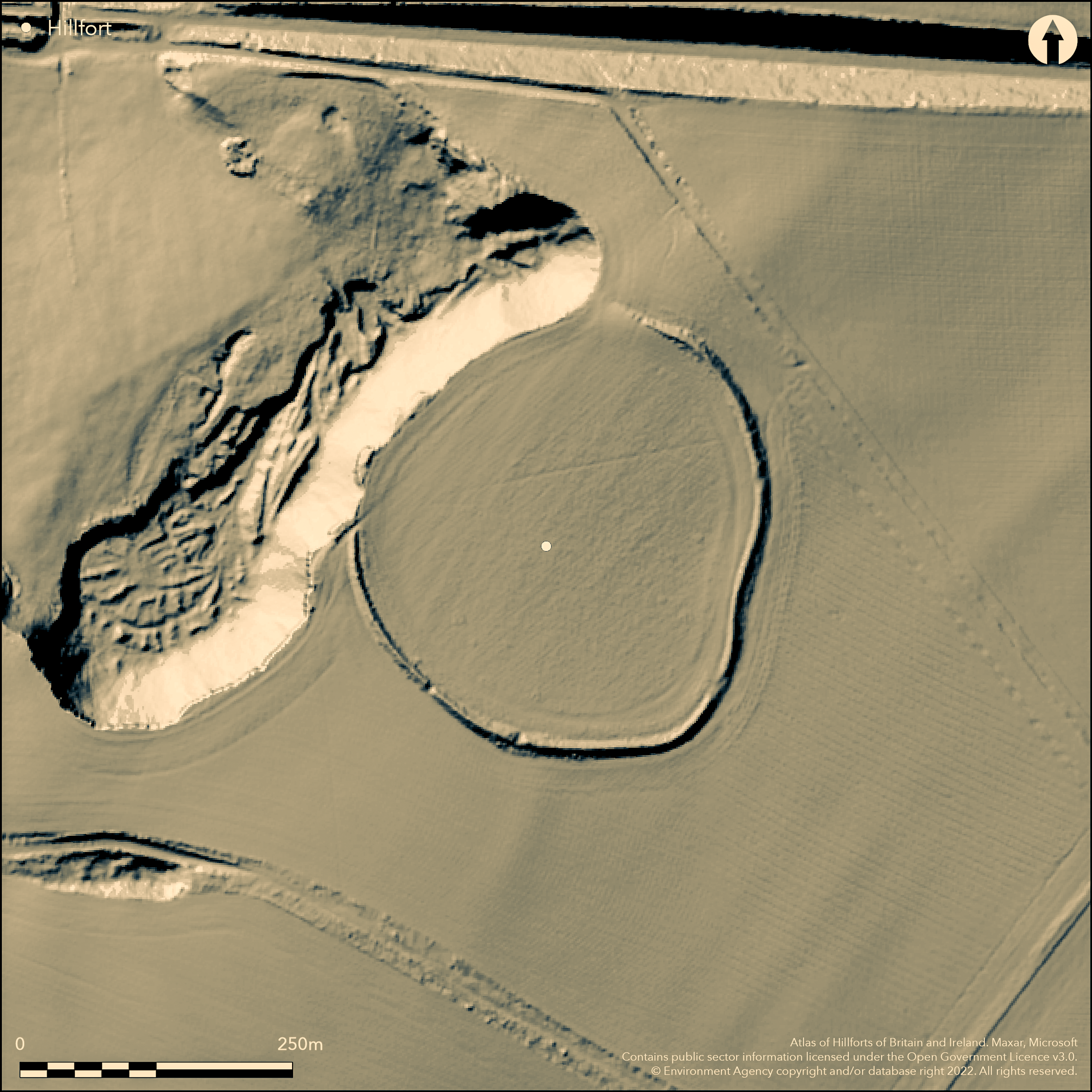
LiDAR 1m DTM Hillshade
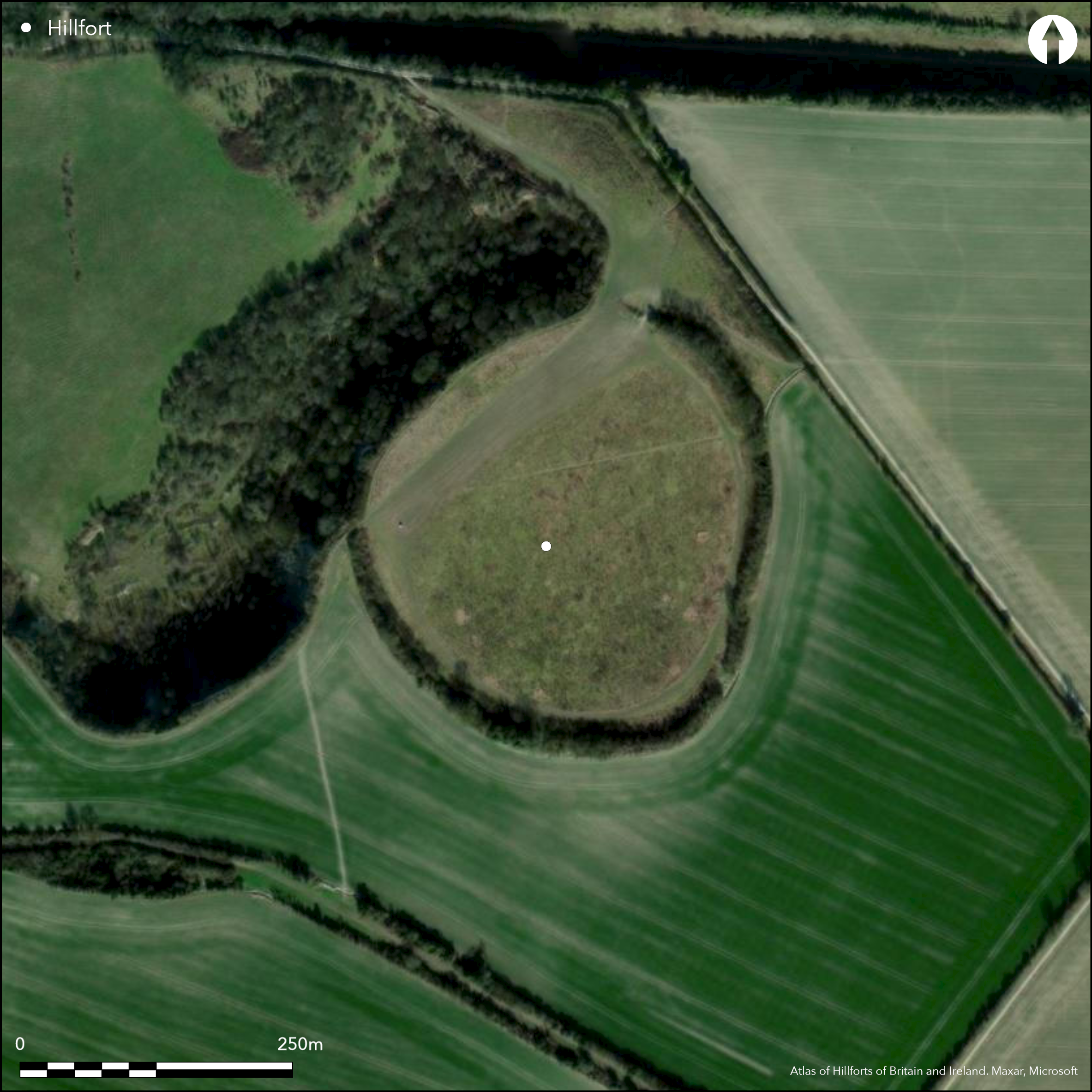
Satellite Imagery
LiDAR 1m DTM Hillshade
Satellite Imagery
Scroll left/right to view further images.
HER: Central Bedfordshire and Luton 666 (None)
NMR: SP 92 SE 6 (346554)
SM: 1015593
NGR: SP 9966 2247
X: 499660 Y: 222470 (OSGB36)
A large univallate hillfort sited 1km to the NE of Totternhoe on a broad plateau overlooking the northern edge of the Chiltern scarp. The sub-circular enclosure measures 235m N-S by 215m E-W enclosing 4.9ha and partially overlies a Neolithic causewayed enclosure identified by Curwen (1930) and Piggott (1931). The bank survives in all but the NW and stands up to 3m high, its summit occupied by a hedgerow. An earthwork survey by Worthington Smith in 1878 showed that damage had already occurred to the ramparts by that time. Rescue recording of the quarry face by members of the Manshead Society between the 1930s and 50's revealed the bank was revetted by large posts for a box rampart with a later attempt to convert to glacis ramparts. An inhumation in a chalk-lined cist, possibly Neolithic, was found beneath the line of the later hillfort ditch. The external V-shaped ditch is now infilled but was still visible in 1900 and recorded in the face of the disused chalk quarry in the NW, where it measured 6.0-9.7m wide and 3m deep. Five breaks have been recorded around the circuit, with only a single 7m wide break in the SE considered to be original. An excavation in 1913 (Smith 1915) revealed post pits and a slot, originally considered to be for a palisade but since interpreted as the western wall of a funnel-shaped timber gateway (Dyer 1955). A large pit at the entrance was found to contain the disarticulated remains of 50 individuals. Further groups of pits were recorded during a geophysical survey in 1991 towards the centre of the hillfort, and in the NW a possible quarry for the ramparts. A circular ditch lying 25m in from the main ramparts was also detected and this is considered to be an earlier, probably late Bronze Age or early Iron Age phase of the hillfort. A small building was recorded in the W, an area that coincides with a concentration of Romano-British pottery (Hamilton and Pollard 1992; Pollard and Hamilton 1994). In 1907 a Roman cremation cemetery was discovered on the NW side of the hillfort which has now been lost to quarrying (Smith 1915). Roman pottery, including Samian ware, quern and glass fragments and an intaglio ring were all recovered. Neolithic and Bronze Age flint tools and debitage have been recovered during fieldwalking. Recorded on 1880 1:2,500 OS mapping
Citizen Science: ✗
Reliability of Data: Confirmed
Reliability of Interpretation: Confirmed
X: -61580 Y: 6780592 (EPSG: 3857)
Longitude: -0.5531850375992033 Latitude: 51.891838380164145 (EPSG:4326)
Country: England; None
Current County or Unitary Authority: Central Bedfordshire
Historic County: Bedfordshire
Current Parish/Community/Council/Townland: Houghton Regis; Tottenhoe; Dunstable
Damaged by ploughing and quarrying. Damage caused by off-road motorcyclists
| Extant | ✓ |
| Cropmark | ✗ |
| Likely Destroyed | ✓ |
None
| Woodland | ✗ |
| Commercial Forestry Plantation | ✗ |
| Parkland | ✗ |
| Pasture (Grazing) | ✗ |
| Arable | ✓ |
| Scrub/Bracken | ✓ |
| Bare Outcrop | ✗ |
| Heather/Moorland | ✗ |
| Heath | ✗ |
| Built-up | ✗ |
| Coastal Grassland | ✗ |
| Other | ✗ |
A contour fort sited at 150m OD on a broad level plateau below the Dunstable Downs and overlooking the northern edge of the Chiltern scarp.
| Contour Fort | ✓ |
| Partial Contour Fort | ✗ |
| Promontory Fort | ✗ |
| Hillslope Fort | ✗ |
| Level Terrain Fort | ✗ |
| Marsh Fort | ✗ |
| Multiple Enclosure Fort | ✗ |
| Hilltop | ✓ |
| Coastal Promontory | ✗ |
| Inland Promontory | ✗ |
| Valley Bottom | ✗ |
| Knoll/Hillock/Outcrop | ✗ |
| Ridge | ✗ |
| Cliff/Plateau-edge/Scarp | ✗ |
| Hillslope | ✗ |
| Lowland | ✗ |
| Spur | ✗ |
Dominant Topographic Feature: Broad plateau
| North | ✗ |
| Northeast | ✗ |
| East | ✗ |
| Southeast | ✗ |
| South | ✗ |
| Southwest | ✗ |
| West | ✗ |
| Northwest | ✗ |
| Level | ✓ |
Altitude: 150.0m
Parish boundary between Totternhoe and Hougton Regis lies to the S. Parish boundary between Dunstable and Hougton Regis lies to the E.
Boundary Type: Parish/Townland
The construction of the ramparts show it was a developed hillfort with geophysical survey providing evidence for an earlier, smaller enclosure, with probable origins in the late Bronze Age. The ramparts overlie a Neolithic causewayed enclosure. The hillfort continued in use into the Roman period with a cemetery and a probable building. The suggested dates are supported by finds of pottery, coins and other artefacts
Reliability: B - Medium
| Pre 1200BC | ✗ |
| 1200BC - 800BC | ✗ |
| 800BC - 400BC | ✓ |
| 400BC - AD50 | ✓ |
| AD50 - AD400 | ✓ |
| AD400 - AD 800 | ✗ |
| Post AD800 | ✗ |
| Unknown | ✗ |
| Pre Hillfort: | None |
| Post Hillfort: | None |
| Artefactual: | None |
| Morphology/Earthwork/Typology: | None |
The earliest known reference to the site was in the late 17th century (Camden 1695). Recorded on 1880 1:2,500 OS mapping. Measured survey by Worthington Smith 1878 (Smith 1894). Between 1890s and 1915 recording of Roman and prehistoric features by Worthington Smith during quarrying (Simco 1984, 107) Limited excavation in 1913 (Smith 1915). Excavations between 1937 and 1951 uncovered several inhumations (Davies 1956; Matthews 1976, 160-2). Field investigation in 1971. Resistance and magnetometry survey in 1991 Surveyed by English Heritage in April 2003, following vandalism and subsequent excavation of part of the rampart and interior. Scheduled
| 1st Identified Written Reference (1695): | None |
| 1st Identified Map Depiction (1880): | None |
| Excavation (1913): | None |
| Other (1929): | Scheduled |
| Other (1971): | Field investigation |
| Other (1974): | Visit by Hillfort Study Group |
| Geophysical Survey (1991): | AML |
| Other (1991): | Fieldwalking |
| Earthwork Survey (2003): | ref: 1066354 |
| Excavation (2003): | None |
| Earthwork Survey (1878): | None |
| Excavation (None): | None |
Large pit at the entrance found to contain the disarticulated remains of 50 individuals. Further groups of pits towards the centre of the hillfort and in the NW a possible quarry for the ramparts. A circular ditch lying 25m in from the main defences is considered to be an earlier, probably late Bronze Age or early Iron Age phase of the hillfort. A small building was also recorded in the W in an area which coincides with a concentration of Romano-British pottery (Hamilton and Pollard 1992; Pollard and Hamilton 1994). In 1907 a Roman cremation cemetery was discovered on the NW side of the hillfort.
None
| None | ✓ |
| Spring | ✗ |
| Stream | ✗ |
| Pool | ✗ |
| Flush | ✗ |
| Well | ✗ |
| Other | ✗ |
None
| No Known Features | ✓ |
| Round Stone Structures | ✗ |
| Rectangular Stone Structures | ✗ |
| Curvilinear Platforms | ✗ |
| Other Roundhouse Evidence | ✗ |
| Pits | ✗ |
| Quarry Hollows | ✗ |
| Other | ✗ |
None
| No Known Excavation | ✗ |
| Pits | ✓ |
| Postholes | ✗ |
| Roundhouses | ✗ |
| Rectangular Structures | ✗ |
| Roads/Tracks | ✗ |
| Quarry Hollows | ✗ |
| Other | ✗ |
| Nothing Found | ✗ |
Earlier enclosure or inner ditch concentric to the ramparts of c.2.7ha (Pollard & Hamilton 1994), undated but could be Neolithic or an earlier phase of the hillfort; possible metalled surface, lengths of ditch, quarry pits. Possible medieval or post medieval trackway observed by Smith (1915)
| No Known Geophysics | ✗ |
| Pits | ✓ |
| Roundhouses | ✗ |
| Rectangular Structures | ✗ |
| Roads/Tracks | ✓ |
| Quarry Hollows | ✓ |
| Other | ✓ |
| Nothing Found | ✗ |
Palaeolithic, Neolithic and Bronze Age stone implements; Roman pottery; animal bones, human remains and inhumations, Roman glass, coins, a Roman intaglio; quern of Andernach lava, bronze axes and metal objects. Sling stones found in ditch fills
| No Known Finds | ✗ |
| Pottery | ✓ |
| Metal | ✓ |
| Metalworking | ✗ |
| Human Bones | ✓ |
| Animal Bones | ✓ |
| Lithics | ✓ |
| Environmental | ✗ |
| Other | ✓ |
None
| APs Not Checked | ✓ |
| None | ✗ |
| Roundhouses | ✗ |
| Rectangular Structures | ✗ |
| Pits | ✗ |
| Postholes | ✗ |
| Roads/Tracks | ✗ |
| Other | ✗ |
Five breaks have been recorded around the circuit, with only a single break in the SE, 7m wide, considered to be original. Excavation revealed the western wall of a funnel-shaped timber gateway.
| 5: | None |
| 2: | None |
Guard Chambers: ✗
Chevaux de Frise: ✗
| 1. Passage-way/Corridor (South east): | Funnel-shaped timber gateway |
Sub-circular measuring 235m N-S by 215m E-W enclosing 4.9ha. The bank survives in all but the NW and stands up to 3m high its summit occupied by a hedgerow. The bank was revetted by large posts for a box rampart with a later attempt to convert to glacis ramparts. The external V-shaped ditch is now infilled but recorded in the face of the disused chalk quarry as 6.0-9.7m wide and 3m deep
| Area 1: | 4.9ha. |
| Total: | 4.9ha. |
Total Footprint Area: Noneha.
None
| ✓ | Earlier inner ditch recorded by geophysics |
| ✓ | None |
| NE Quadrant: | 1 |
| SE Quadrant: | 1 |
| SW Quadrant: | 1 |
| NW Quadrant: | 1 |
| Total: | 1 |
| Partial Univallate | ✗ |
| Univallate | ✓ |
| Partial Bivallate | ✗ |
| Bivallate | ✗ |
| Partial Multivallate | ✗ |
| Multivallate | ✗ |
| Unknown | ✗ |
| Partial Univallate | ✗ |
| Univallate | ✓ |
| Partial Bivallate | ✗ |
| Bivallate | ✗ |
| Partial Multivallate | ✗ |
| Multivallate | ✗ |
None
| None | ✗ |
| Earthen Bank | ✓ |
| Stone Wall | ✗ |
| Rubble | ✗ |
| Wall-walk | ✗ |
| Evidence of Timber | ✗ |
| Vitrification | ✗ |
| Other Burning | ✗ |
| Palisade | ✗ |
| Counter Scarp Bank | ✗ |
| Berm | ✗ |
| Unfinished | ✗ |
| Other | ✗ |
None
| None | ✗ |
| Earthen Bank | ✓ |
| Stone Wall | ✗ |
| Murus Duplex | ✗ |
| Timber-framed | ✓ |
| Timber-laced | ✗ |
| Vitrification | ✗ |
| Other Burning | ✗ |
| Palisade | ✗ |
| Counter Scarp Bank | ✗ |
| Berm | ✗ |
| Unfinished | ✗ |
| No Known Excavation | ✗ |
| Other | ✗ |
| ✗ | None |
| ✓ | None |
Number of Ditches: 1
| ✗ | None |
Barber, M. and Topping, P. 1994. Maiden Bower, Bedfordshire. Neolithic Industry and Enclosure. RCHME.
Camden, W. 1695. Britannia. Facsimiie of the 1695 edition, published by Gibson 1971
Curwen, E. C. 1930. Neolithic Camps. Antiquity IV, 22-54
Davies, G.H. 1956. Maiden Bower near Dunstable, Bedfordshire Archaeologist. 1, 98-101
Dyer, J. 1955. Maiden Bower, near Dunstable. Bedfordshire Archaeol J. 1(1) 46-52
Hamilton, M.A. and Pollard, C.J. 1992. Maiden Bower, Bedfordshire: interim report on survey work, October 1991. Manshead J. 32, 24-31
Piggott, S. 1931. The Neolithic pottery of the British Isles. Antiq J. 88, 67-159
Pollard, J. and Hamilton, M. 1994. Recent fieldwork at Maiden Bower. Bedfordshire Arch. Vol. 21, 10-18
Simco, A. 1984. Survey of Bedfordshire: The Roman Period. Bedfordshire County Council & RCHME
Smith, W.G. 1915. Maiden Bower, Bedfordshire. Proc Soc Antiq XXVII, 143-61
Smith, W.G. 1894. Man the Primal Savage: his haunts and relics from the hill-tops of Bedfordshire to Blackwall London. London, Edward Stanford.
Matthews, C. L. 1976. Occupation Sites on the Chiltern Ridge. BAR 29, Oxford. British Archaeological Reports
Atlas of Hillforts:
Wikidata:
This work is licensed under CC BY-SA 4.0

 and should be cited as:
Lock, Gary and Ralston, Ian. 2024. Atlas of Hillforts of Britain and Ireland. Available at: https://hillforts.arch.ox.ac.uk
Document Version 1.1