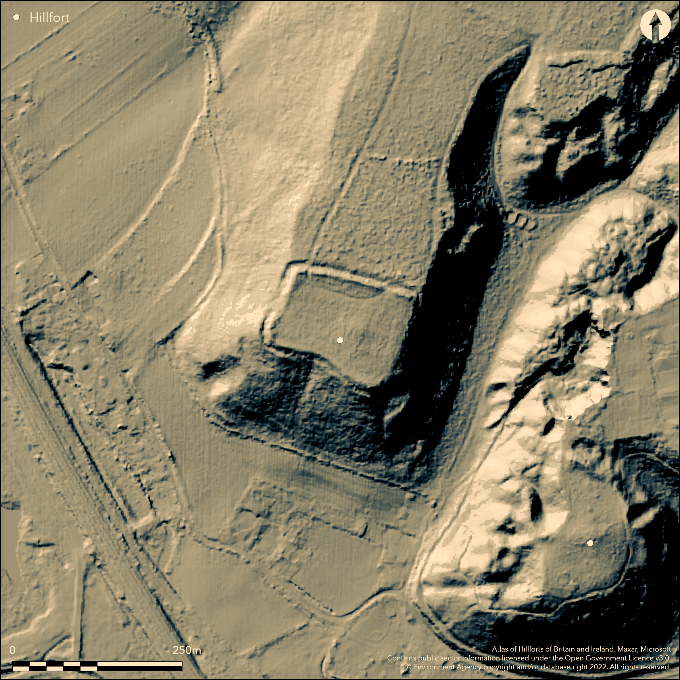
LiDAR 1m DTM Hillshade
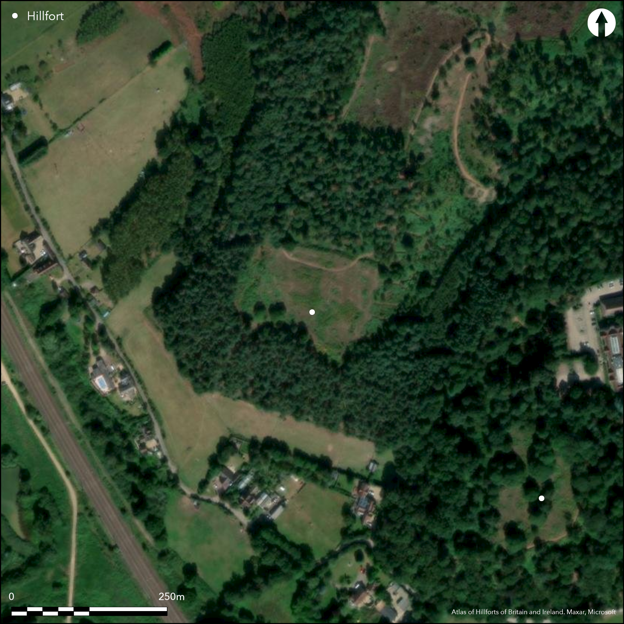
Satellite Imagery
LiDAR 1m DTM Hillshade
Satellite Imagery
Scroll left/right to view further images.
HER: Central Bedfordshire and Luton 445 (None)
NMR: TL 14 NE 7 (362659)
SM: 1015555
NGR: TL 1849 4782
X: 518491 Y: 247824 (OSGB36)
Sited in the SW corner of the RSPB nature reserve at Sandy, a slight univallate hillfort of 0.8ha. It occupies a prominent position at 60m OD on the southern end of a narrow sandstone spur with extensive views along the Ivel Valley in the N. It is one of three hillforts in close proximity, with Caesar's Camp (Atlas No. 3297) lying 1.2km to the NW and Sandy Lodge Promontory Fort (Atlas No. 2399) lying 250m to the SE across a dry valley. The enclosure is rectangular in plan measuring approximately 60m N-S by 110m E-W with rounded corners, the form of the enclosure determined by the topography of the spur. The ground falls away steeply in all but the N where the ramparts stand 1.5m high and 6m wide with an external 6m wide ditch now 0.8m deep. A borehole survey in the SW showed the ditch was 1.5m deep below the ground surface in that area (Halsey 2006). The short section of ditch continues from the NE corner which, together with a slight break in slope 9m below the summit, suggests some modification occurred across the slope which has since been masked by soil erosion. In the S and W a slight counterscarp bank has been observed beyond the ditch. In the SE corner the ramparts merge into the natural contours of the spur and in the E it appears to have been naturally defined by the steepness of the slopes. Three causeways are visible in the N where the ground is level and easily accessible. Two of these carry modern tracks. An original 3m-wide entrance was identified in this region during investigations of the hillfort (Archer 2006). A low mound within the interior (McOmish 2005) was found by excavation to be associated with a NW/SE ditch 1.8m wide and 0.75m deep, running parallel with the main axis of the hillfort and possibly representing an internal division within the enclosed space. A possible gap in the ditch aligns with the entrance and it was suggested by the investigators that this might represent a route through the hillfort. A pit and postholes were also recorded. A borehole survey within the interior (Halsey 2006) revealed the presence of a ditch 0.8m deep and 2m wide in the SW corner or the hlllfort, possibly of an earlier enclosure. Dates from pottery suggests a late Bronze Age/early Iron Age origin for the hillfort. The site is recorded on 1884 1:2,500 OS mapping.
Citizen Science: ✗
Reliability of Data: Confirmed
Reliability of Interpretation: Confirmed
X: -30156 Y: 6821128 (EPSG: 3857)
Longitude: -0.27090013694011067 Latitude: 52.116008208853344 (EPSG:4326)
Country: England
Current County or Unitary Authority: Central Bedfordshire
Historic County: Bedfordshire
Current Parish/Community/Council/Townland: Sandy
Land under higher level stewardship (RSPB)
| Extant | ✓ |
| Cropmark | ✗ |
| Likely Destroyed | ✗ |
Heathland bordered by woodland.
| Woodland | ✓ |
| Commercial Forestry Plantation | ✗ |
| Parkland | ✗ |
| Pasture (Grazing) | ✗ |
| Arable | ✗ |
| Scrub/Bracken | ✗ |
| Bare Outcrop | ✗ |
| Heather/Moorland | ✗ |
| Heath | ✓ |
| Built-up | ✗ |
| Coastal Grassland | ✗ |
| Other | ✗ |
A slight contour fort occupying a prominent position at 60m OD on the southern end of a narrow sandstone spur
| Contour Fort | ✓ |
| Partial Contour Fort | ✗ |
| Promontory Fort | ✗ |
| Hillslope Fort | ✗ |
| Level Terrain Fort | ✗ |
| Marsh Fort | ✗ |
| Multiple Enclosure Fort | ✗ |
| Hilltop | ✓ |
| Coastal Promontory | ✗ |
| Inland Promontory | ✗ |
| Valley Bottom | ✗ |
| Knoll/Hillock/Outcrop | ✗ |
| Ridge | ✗ |
| Cliff/Plateau-edge/Scarp | ✗ |
| Hillslope | ✗ |
| Lowland | ✗ |
| Spur | ✓ |
Dominant Topographic Feature: Spur
| North | ✗ |
| Northeast | ✗ |
| East | ✗ |
| Southeast | ✗ |
| South | ✗ |
| Southwest | ✗ |
| West | ✗ |
| Northwest | ✗ |
| Level | ✓ |
Altitude: 60.0m
N/A
The form of ramparts, together with fragments of pottery recovered from the surface of the interior suggest an Iron Age origin. Quantities of worked and burnt flint, late Bronze Age/early Iron Age pottery, and animal bone were recovered from secure deposits in the western bank and surrounding ditches during a borehole survey, suggesting the hillfort had its origins in the late Bronze Age or early Iron Age. Three sherds of early Bronze Age pottery and probable Neolithic/Mesolithic flints were also recovered
Reliability: B - Medium
| Pre 1200BC | ✗ |
| 1200BC - 800BC | ✓ |
| 800BC - 400BC | ✓ |
| 400BC - AD50 | ✗ |
| AD50 - AD400 | ✗ |
| AD400 - AD 800 | ✗ |
| Post AD800 | ✗ |
| Unknown | ✗ |
| Pre Hillfort: | None |
| Post Hillfort: | None |
| Artefactual: | None |
| Morphology/Earthwork/Typology: | None |
Recorded on 1884 1:2,500 OS mapping. English Heritage analytical earthwork survey 2005. Field investigation in 1969, Scheduled in 1962. Excavation by Albion Archaeology for English Heritage and the Royal Society for the Protection of Birds (RSPB) in 2006. Borehole Survey by MOLAS 2006 comprising two transects, one across the inner and outer bank and ditch in the SW and one across the interior.
| 1st Identified Map Depiction (1884): | None |
| Other (1962): | Scheduled |
| Other (1969): | Field investigation |
| Earthwork Survey (2005): | None |
| Other (2006): | Borehole survey carried out by MOLAS |
| Excavation (2006): | Trial trenches |
A low mound within the interior (McOmish 2005) was found by excavation to be associated with a NW/SE ditch 1.8m wide and 0.75m deep, running parallel with the main axis of the hillfort and possibly representing an internal division within the enclosed space. Pottery.
River Ivel to the SW
| None | ✓ |
| Spring | ✗ |
| Stream | ✗ |
| Pool | ✗ |
| Flush | ✗ |
| Well | ✗ |
| Other | ✗ |
Low mound
| No Known Features | ✗ |
| Round Stone Structures | ✗ |
| Rectangular Stone Structures | ✗ |
| Curvilinear Platforms | ✗ |
| Other Roundhouse Evidence | ✗ |
| Pits | ✗ |
| Quarry Hollows | ✗ |
| Other | ✓ |
Possible bank and ditch division within the hillfort. Single pit and postholes recorded
| No Known Excavation | ✗ |
| Pits | ✓ |
| Postholes | ✓ |
| Roundhouses | ✗ |
| Rectangular Structures | ✗ |
| Roads/Tracks | ✗ |
| Quarry Hollows | ✗ |
| Other | ✓ |
| Nothing Found | ✗ |
None
| No Known Geophysics | ✓ |
| Pits | ✗ |
| Roundhouses | ✗ |
| Rectangular Structures | ✗ |
| Roads/Tracks | ✗ |
| Quarry Hollows | ✗ |
| Other | ✗ |
| Nothing Found | ✗ |
None
| No Known Finds | ✗ |
| Pottery | ✓ |
| Metal | ✗ |
| Metalworking | ✗ |
| Human Bones | ✗ |
| Animal Bones | ✗ |
| Lithics | ✗ |
| Environmental | ✗ |
| Other | ✗ |
None
| APs Not Checked | ✗ |
| None | ✓ |
| Roundhouses | ✗ |
| Rectangular Structures | ✗ |
| Pits | ✗ |
| Postholes | ✗ |
| Roads/Tracks | ✗ |
| Other | ✗ |
Three causeways are visible in the N where the ground is level and easily accessible. Two of these carry modern tracks but a break located 30m from the eastern end of the hillfort is most probably original
| 3: | None |
| 2: | None |
Guard Chambers: ✗
Chevaux de Frise: ✗
| 1. Other Forms (North): | Causeway |
Rectangular in plan with rounded corners, enclosing 0.8ha. It measures approximately 60m N-S by 110m E-W, the form of the enclosure determined by the topography of the spur. The ground falls away steeply in all but the N where the ramparts stand 1.5m high and 6m wide with an external 6m wide ditch which is in-filled and now 0.8m deep but where investigated shown to be 1.5m deep below the ground surface. The short section of ditch continues from the NE corner which, together with a slight break in slope 9m below the summit, suggests some modification occurred across this slope which has since been masked by soil erosion. In the S and W a slight counterscarp has been observed beyond the ditch. In the SE corner the defences merge into the natural contours of the spur and in the E it appears to have been naturally defended by the steepness of the slopes
| Area 1: | 0.8ha. |
| Total: | 0.8ha. |
Total Footprint Area: Noneha.
None
| ✗ | None |
| ✗ | None |
| NE Quadrant: | 1 |
| SE Quadrant: | 1 |
| SW Quadrant: | 1 |
| NW Quadrant: | 1 |
| Total: | 1 |
| Partial Univallate | ✗ |
| Univallate | ✓ |
| Partial Bivallate | ✗ |
| Bivallate | ✗ |
| Partial Multivallate | ✗ |
| Multivallate | ✗ |
| Unknown | ✗ |
| Partial Univallate | ✗ |
| Univallate | ✗ |
| Partial Bivallate | ✗ |
| Bivallate | ✗ |
| Partial Multivallate | ✗ |
| Multivallate | ✗ |
None
| None | ✗ |
| Earthen Bank | ✓ |
| Stone Wall | ✗ |
| Rubble | ✗ |
| Wall-walk | ✗ |
| Evidence of Timber | ✗ |
| Vitrification | ✗ |
| Other Burning | ✗ |
| Palisade | ✗ |
| Counter Scarp Bank | ✓ |
| Berm | ✗ |
| Unfinished | ✗ |
| Other | ✗ |
Shown by borehole survey
| None | ✗ |
| Earthen Bank | ✓ |
| Stone Wall | ✗ |
| Murus Duplex | ✗ |
| Timber-framed | ✗ |
| Timber-laced | ✗ |
| Vitrification | ✗ |
| Other Burning | ✗ |
| Palisade | ✗ |
| Counter Scarp Bank | ✗ |
| Berm | ✗ |
| Unfinished | ✗ |
| No Known Excavation | ✗ |
| Other | ✗ |
| ✗ | None |
| ✓ | None |
Number of Ditches: 1
| ✗ | None |
Archer, J. 2006. Galley Hill Hillfort, Sandy, Bedfordshire. Archaeological Field Evaluation. Albion Archaeology Document 2006/59.
McOmish, D. 2005. Galley Hill, Sandy, Bedfordshire. English Heritage Survey Report. Archaeological Investigation
Series 06/2005.
Halsey, C. 2006. Galley Hill Hillfort, Sandy, Bedfordshire. Report on Geoarchaeological Borehole Survey. Museum of London Archaeology Service
Atlas of Hillforts:
Wikidata:
This work is licensed under CC BY-SA 4.0

 and should be cited as:
Lock, Gary and Ralston, Ian. 2024. Atlas of Hillforts of Britain and Ireland. Available at: https://hillforts.arch.ox.ac.uk
Document Version 1.1