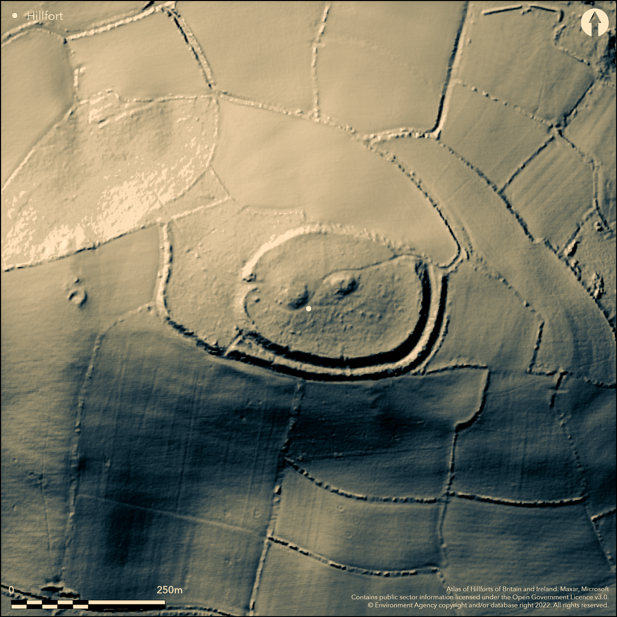
LiDAR 1m DTM Hillshade
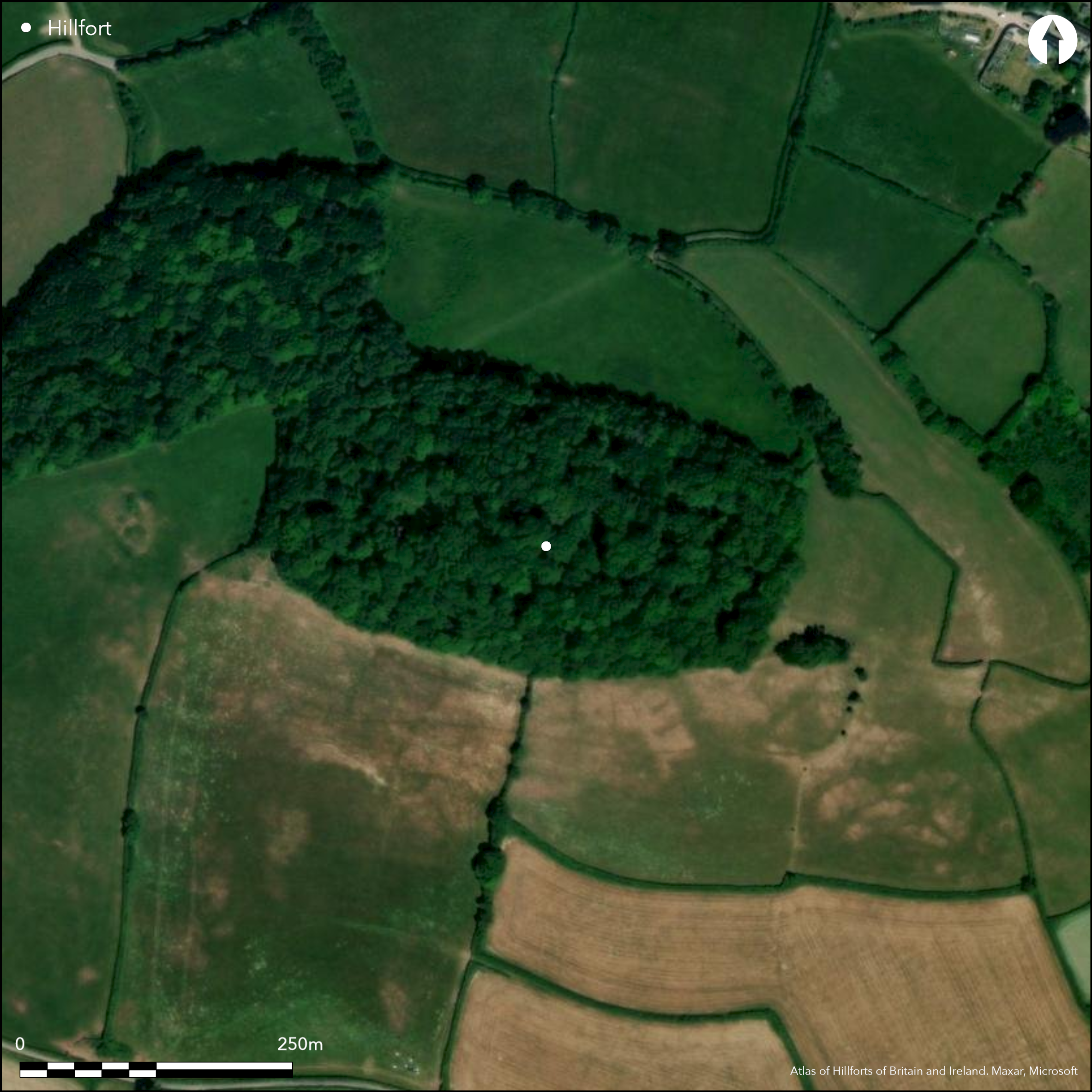
Satellite Imagery
LiDAR 1m DTM Hillshade
Satellite Imagery
Scroll left/right to view further images.
HER: Devon MDV8603 (None)
NMR: SX 86 NW 2 (446232)
SM: 1003857
NGR: SX81696851
X: 281658 Y: 68511 (OSGB36)
Prominent contour hillfort located on isolated hill top spur of volcanic rock and Devonian limestone between the major Teign and Dart valleys. Suggested by Fox (1952) as 'paired' with Milber Down (Atlas No 3344) to NE. Steep surrounding slopes, very steep in parts, site covers c. 2ha of summit of hill. Substantial inner bank for circuit, with ditch present on on E, S and SW sides. On N, slope steepest and suggested by RCHME on 1992 survey as ploughed-out, although may never have been present. Steeply sloping inturned W entrance. From NE corner a second and outer bank runs along the S side of the fort to meet a possible entrance gap at SW apex where a short length of bank crosses the gap to the inner rampart. The outer bank then runs NW and the N and then petering out, to suggest a W second-phase annexe to the site. RCHME suggest this N part has been ploughed-out, Fox (1996) suggesting unfinished. However, this termination of the rampart may have been intentional and interpretation difficult, as is interpretation of the site in general. Two large round barrows in interior. Interior possibly ploughed in past. Well-preserved Devon County Council site. On 1st Ed. OS map (1888). Minimal investigations, undated.
Citizen Science: ✗
Reliability of Data: Confirmed
Reliability of Interpretation: Confirmed
X: -408566 Y: 6534080 (EPSG: 3857)
Longitude: -3.670206622295172 Latitude: 50.50433584616119 (EPSG:4326)
Country: England
Current County or Unitary Authority: Devon
Historic County: Devon
Current Parish/Community/Council/Townland: Denbury and Torbryan
Well-preserved Devon County Council site. Interior possibly ploughed in past.
| Extant | ✓ |
| Cropmark | ✗ |
| Likely Destroyed | ✗ |
Dense wooded site, first planted c. 1810-15.
| Woodland | ✓ |
| Commercial Forestry Plantation | ✗ |
| Parkland | ✗ |
| Pasture (Grazing) | ✗ |
| Arable | ✗ |
| Scrub/Bracken | ✗ |
| Bare Outcrop | ✗ |
| Heather/Moorland | ✗ |
| Heath | ✗ |
| Built-up | ✗ |
| Coastal Grassland | ✗ |
| Other | ✗ |
Prominent contour hillfort located on isolated hill top spur of volcanic rock and Devonian limestone between the major rivers Teign and Dart valleys. Steep surrounding slopes, very steep in parts.
| Contour Fort | ✓ |
| Partial Contour Fort | ✗ |
| Promontory Fort | ✗ |
| Hillslope Fort | ✗ |
| Level Terrain Fort | ✗ |
| Marsh Fort | ✗ |
| Multiple Enclosure Fort | ✗ |
| Hilltop | ✓ |
| Coastal Promontory | ✗ |
| Inland Promontory | ✗ |
| Valley Bottom | ✗ |
| Knoll/Hillock/Outcrop | ✗ |
| Ridge | ✗ |
| Cliff/Plateau-edge/Scarp | ✗ |
| Hillslope | ✗ |
| Lowland | ✗ |
| Spur | ✓ |
Dominant Topographic Feature: Hill top
| North | ✗ |
| Northeast | ✗ |
| East | ✗ |
| Southeast | ✗ |
| South | ✗ |
| Southwest | ✗ |
| West | ✗ |
| Northwest | ✗ |
| Level | ✓ |
Altitude: 152.0m
N/A
None.
Reliability: D - None
| Pre 1200BC | ✗ |
| 1200BC - 800BC | ✗ |
| 800BC - 400BC | ✗ |
| 400BC - AD50 | ✗ |
| AD50 - AD400 | ✗ |
| AD400 - AD 800 | ✗ |
| Post AD800 | ✗ |
| Unknown | ✓ |
| Pre Hillfort: | Two large round barrows in interior. |
| Post Hillfort: | Possible medieval and post-medieval cultivation modifications to site and 18th century embellishments. |
On 1st Ed. OS map (1888). Surveyed at 1:1000 by RCHME 1992, ref. no. 890489.
| 1st Identified Map Depiction (1888): | OS map. |
| Earthwork Survey (1992): | Survey at 1:1000 by RCHME. |
| Other (2013): | Visited by Hillfort Study Group |
None.
None
| None | ✓ |
| Spring | ✗ |
| Stream | ✗ |
| Pool | ✗ |
| Flush | ✗ |
| Well | ✗ |
| Other | ✗ |
None
| No Known Features | ✓ |
| Round Stone Structures | ✗ |
| Rectangular Stone Structures | ✗ |
| Curvilinear Platforms | ✗ |
| Other Roundhouse Evidence | ✗ |
| Pits | ✗ |
| Quarry Hollows | ✗ |
| Other | ✗ |
None
| No Known Excavation | ✓ |
| Pits | ✗ |
| Postholes | ✗ |
| Roundhouses | ✗ |
| Rectangular Structures | ✗ |
| Roads/Tracks | ✗ |
| Quarry Hollows | ✗ |
| Other | ✗ |
| Nothing Found | ✗ |
None
| No Known Geophysics | ✓ |
| Pits | ✗ |
| Roundhouses | ✗ |
| Rectangular Structures | ✗ |
| Roads/Tracks | ✗ |
| Quarry Hollows | ✗ |
| Other | ✗ |
| Nothing Found | ✗ |
None
| No Known Finds | ✓ |
| Pottery | ✗ |
| Metal | ✗ |
| Metalworking | ✗ |
| Human Bones | ✗ |
| Animal Bones | ✗ |
| Lithics | ✗ |
| Environmental | ✗ |
| Other | ✗ |
None
| APs Not Checked | ✓ |
| None | ✗ |
| Roundhouses | ✗ |
| Rectangular Structures | ✗ |
| Pits | ✗ |
| Postholes | ✗ |
| Roads/Tracks | ✗ |
| Other | ✗ |
Steeply sloping inturned W entrance. NE gap possibly modern track. Possible entrance break through outer bank only on SW.
| 3: | NE gap possibly modern track. |
| 2: | None |
Guard Chambers: ✗
Chevaux de Frise: ✗
| 1. In-turned (West): | None |
| 2. Simple Gap (South west): | Possible entrance break through outer bank only. |
Substantial inner bank for circuit, with ditch present on on E, S and SW sides. On N, slope steepest and suggested by RCHME on 1992 survey as ploughed-out, although may never have been present. From NE corner a second and outer bank runs along the S side of the fort to meet a possible entrance gap at SW apex where a short length of bank crosses the gap to the inner rampart.
| Area 1: | 2.0ha. |
| Total: | 2.0ha. |
Total Footprint Area: Noneha.
None
| ✗ | None |
| ✓ | None |
| NE Quadrant: | 1 |
| SE Quadrant: | 2 |
| SW Quadrant: | 2 |
| NW Quadrant: | 1 |
| Total: | 2 |
| Partial Univallate | ✓ |
| Univallate | ✗ |
| Partial Bivallate | ✓ |
| Bivallate | ✗ |
| Partial Multivallate | ✗ |
| Multivallate | ✗ |
| Unknown | ✗ |
| Partial Univallate | ✗ |
| Univallate | ✗ |
| Partial Bivallate | ✗ |
| Bivallate | ✗ |
| Partial Multivallate | ✗ |
| Multivallate | ✗ |
Outer bank then runs NW and the N and then petering out, to suggest a W second-phase annexe to the site. RCHME suggest this N part has been ploughed-out, Fox (1996) suggesting unfinished.
| None | ✗ |
| Earthen Bank | ✓ |
| Stone Wall | ✗ |
| Rubble | ✗ |
| Wall-walk | ✗ |
| Evidence of Timber | ✗ |
| Vitrification | ✗ |
| Other Burning | ✗ |
| Palisade | ✗ |
| Counter Scarp Bank | ✗ |
| Berm | ✗ |
| Unfinished | ✓ |
| Other | ✗ |
None
| None | ✗ |
| Earthen Bank | ✗ |
| Stone Wall | ✗ |
| Murus Duplex | ✗ |
| Timber-framed | ✗ |
| Timber-laced | ✗ |
| Vitrification | ✗ |
| Other Burning | ✗ |
| Palisade | ✗ |
| Counter Scarp Bank | ✗ |
| Berm | ✗ |
| Unfinished | ✗ |
| No Known Excavation | ✓ |
| Other | ✗ |
| ✗ | None |
| ✓ | Ditch present on on E, S and SW sides. On N, slope steepest and suggested by RCHME on 1992 survey as ploughed-out, although may never have been present. |
Number of Ditches: 1
| ✓ | Outer bank runs NW, then N, and peters out, to suggest a W second-phase annexe to the site. RCHME suggest this N part has been ploughed-out, Fox (1996) suggesting unfinished. |
Fox, A. 1952. Hill-slope forts and related earthworks in South-West England and South Wales, Archaeol J, 109, 1-22
Fox, A. 1996. Prehistoric hillforts in Devon, Tiverton: Devon Books.
Griffith, F.M. and Wilkes, E.M. 2011. In the footsteps of pioneering women: some recent work on Devon hillforts, In Pearce, S (ed). Recent archaeological work in South-Western Britain, BAR British Series 548.
Atlas of Hillforts:
Wikidata:
This work is licensed under CC BY-SA 4.0

 and should be cited as:
Lock, Gary and Ralston, Ian. 2024. Atlas of Hillforts of Britain and Ireland. Available at: https://hillforts.arch.ox.ac.uk
Document Version 1.1