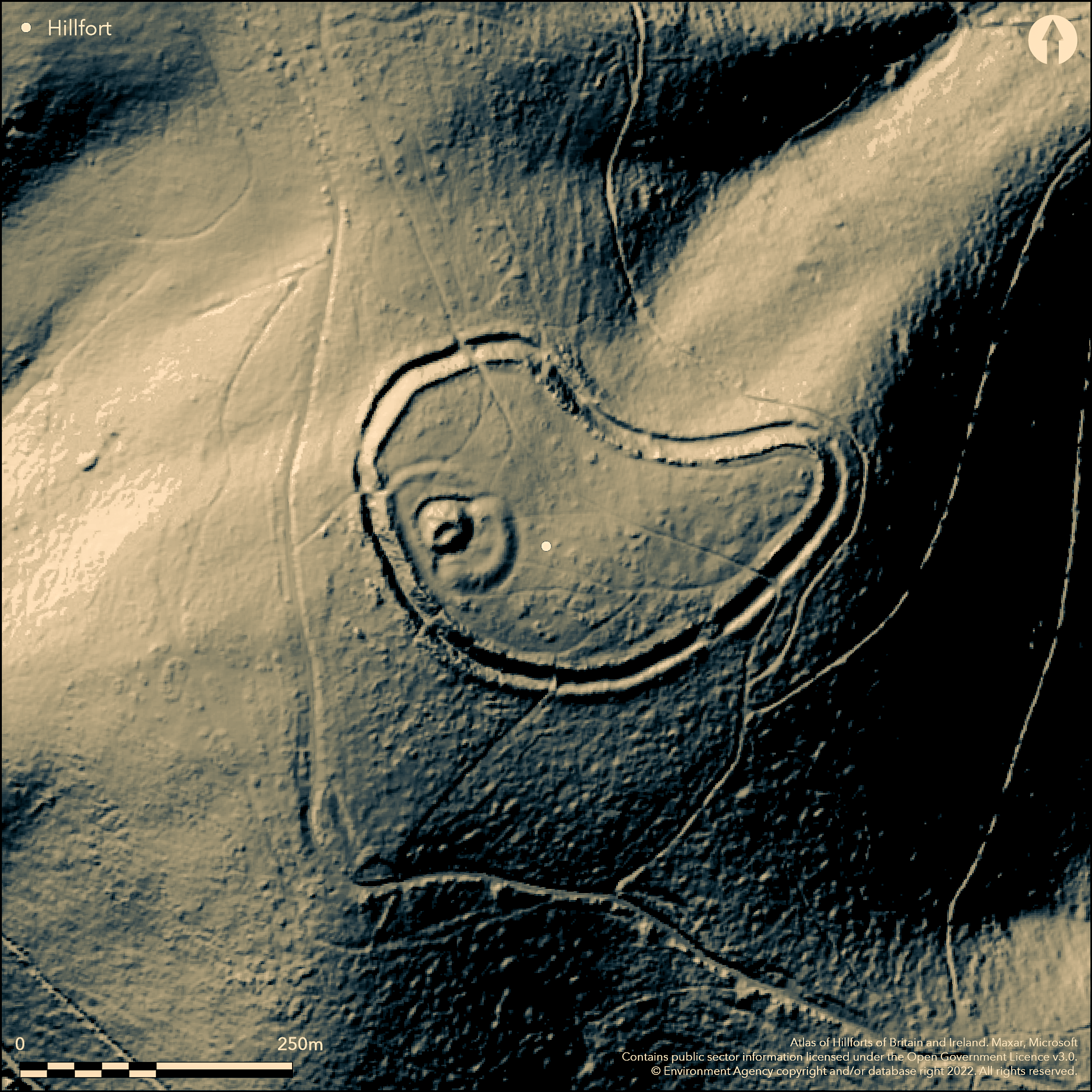
LiDAR 1m DTM Hillshade
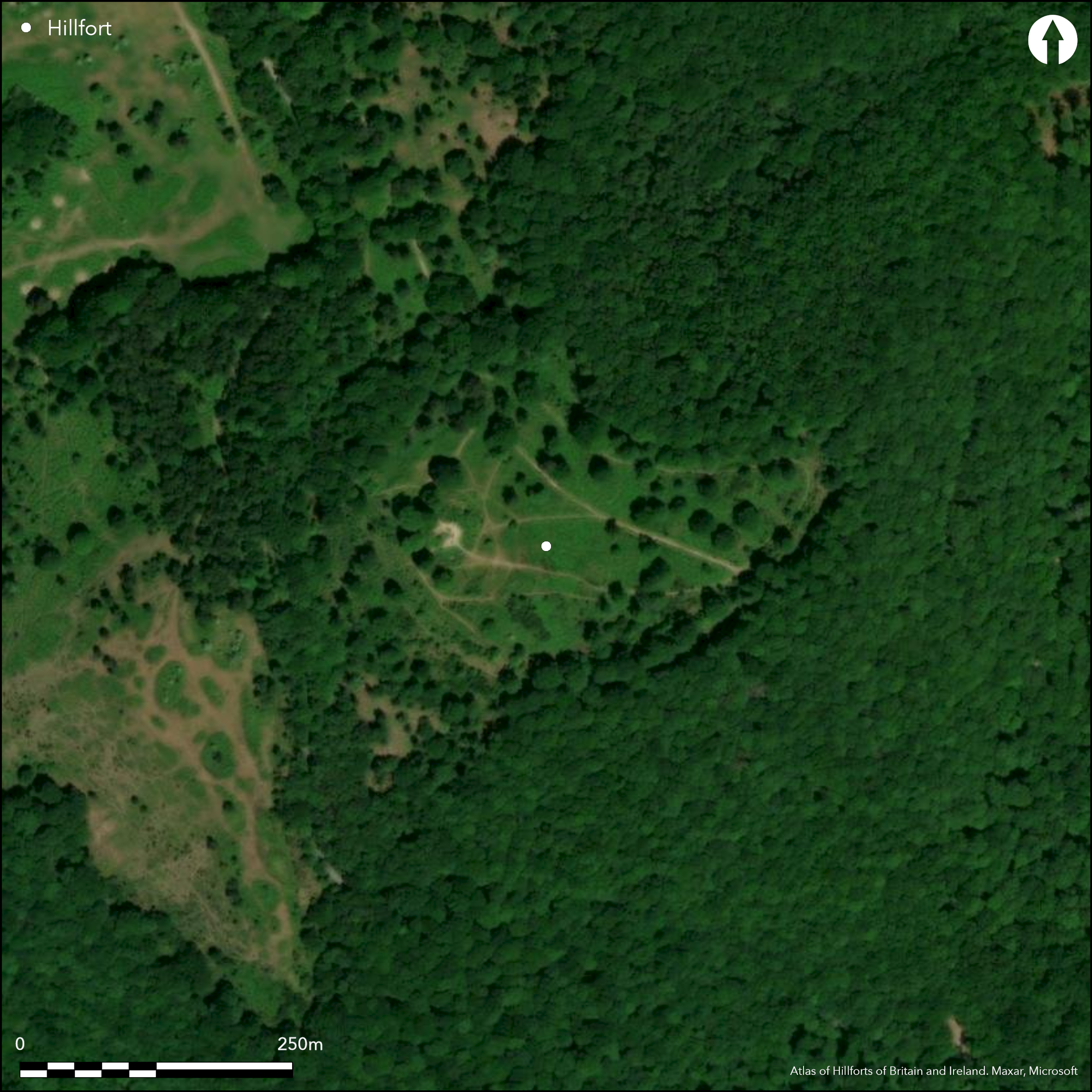
Satellite Imagery
LiDAR 1m DTM Hillshade
Satellite Imagery
Scroll left/right to view further images.
HER: Devon MDV7776 (None)
NMR: SX 76 NW 7 (444797)
SM: 1003859
NGR: SX72636845
X: 272608 Y: 68428 (OSGB36)
Substantial, partial contour hillfort located on hill top in commanding position on SE end of ridge above bend of the River Dart on E. Very steep slopes on E (to River Dart) and SE, steep on NE, S and SW, moderate on N. Site slopes across contours to E. One of number of hillforts located around fringes of high Dartmoor, including Denbury (Atlas No 3345) c. 9km to E. Maximum internal dimensions 300m, with area c. 3ha. Defined by two encircling ramparts with medial ditch, inner with possible palisade. Possible construction earthen core faced with rubble. Present stone wall running inside of rampart modern. Medial ditch silted, with series of causeways crossing it at intervals. Outer bank substantial and whether counterscarp uncertain.counterscarp. SE entrance gaps through both ramparts with causeway across ditch with three other modern gaps. Suggested that the entrance had possible timber tower linked to surrounding palisade and gave access to River Dart (Fox 1996). Possible surface traces of at least four roundhouses. Motte and bailey castle (Dane's Castle) set on W summit of interior, consisting of central grass covered mound with encircling ditch and bank, bailey and outer rampart. The motte c. 32 metres diameter at base and remains of bailey lie 18m beyond mound. On W side bailey bank runs to inner rampart. Gorse and other scrub and scattered trees (some large) generally, with much bracken and trees on banks. Wooded surrounds. Well-preserved despite dense vegetation. Modern track across interior though SE and NNW gaps through ramparts. On 1st Ed. OS map (1886). Minimal investigations, undated.
Citizen Science: ✓
Reliability of Data: Confirmed
Reliability of Interpretation: Confirmed
X: -422762 Y: 6533617 (EPSG: 3857)
Longitude: -3.797734490046256 Latitude: 50.50168938607913 (EPSG:4326)
Country: England; None
Current County or Unitary Authority: Devon
Historic County: Devon
Current Parish/Community/Council/Townland: West Buckfastleigh; Ashburton
Well-preserved despite dense vegetation. Modern track across interior though SE and NNW gaps through ramparts. Motte and bailey castle.
| Extant | ✓ |
| Cropmark | ✗ |
| Likely Destroyed | ✗ |
Gorse and other scrub and scattered trees (some large) generally, with much bracken and trees on banks. Wooded surrounds. Motte and bailey castle. SSSI.
| Woodland | ✓ |
| Commercial Forestry Plantation | ✗ |
| Parkland | ✗ |
| Pasture (Grazing) | ✗ |
| Arable | ✗ |
| Scrub/Bracken | ✓ |
| Bare Outcrop | ✗ |
| Heather/Moorland | ✗ |
| Heath | ✗ |
| Built-up | ✗ |
| Coastal Grassland | ✗ |
| Other | ✓ |
Substantial partial contour hillfort located on hill top in commanding position on SE end of ridge above bend of the River Dart on E. Very steep slopes on E (to River Dart) and SE, steep on NE, S and SW, moderate on N. Site slopes across contours to E.
| Contour Fort | ✗ |
| Partial Contour Fort | ✓ |
| Promontory Fort | ✗ |
| Hillslope Fort | ✗ |
| Level Terrain Fort | ✗ |
| Marsh Fort | ✗ |
| Multiple Enclosure Fort | ✗ |
| Hilltop | ✓ |
| Coastal Promontory | ✗ |
| Inland Promontory | ✗ |
| Valley Bottom | ✗ |
| Knoll/Hillock/Outcrop | ✗ |
| Ridge | ✓ |
| Cliff/Plateau-edge/Scarp | ✗ |
| Hillslope | ✗ |
| Lowland | ✗ |
| Spur | ✗ |
Dominant Topographic Feature: Hill top ridge
| North | ✗ |
| Northeast | ✗ |
| East | ✓ |
| Southeast | ✗ |
| South | ✗ |
| Southwest | ✗ |
| West | ✗ |
| Northwest | ✗ |
| Level | ✗ |
Altitude: 180.0m
Boundary Type: Parish/Townland
None.
Reliability: D - None
| Pre 1200BC | ✗ |
| 1200BC - 800BC | ✗ |
| 800BC - 400BC | ✗ |
| 400BC - AD50 | ✗ |
| AD50 - AD400 | ✗ |
| AD400 - AD 800 | ✗ |
| Post AD800 | ✗ |
| Unknown | ✓ |
| Pre Hillfort: | Bronze Age? axe found on site. |
| Post Hillfort: | Motte and bailey castle set on W summit of interior. Possible Civil War human remains found on site. |
In Aubrey's Monumenta Britannica (1665-1693). On 1st Ed. OS map (1886). RCHME survey, ref. no. 621949.
| 1st Identified Map Depiction (1886): | OS map., |
| Other (2013): | Visited by Hillfort Study Group |
| 1st Identified Written Reference (None): | None |
| Earthwork Survey (None): | RCHME survey. |
Possible traces of at least four roundhouses. Bronze Age axe and human bone found - possibly Civil War.
None
| None | ✓ |
| Spring | ✗ |
| Stream | ✗ |
| Pool | ✗ |
| Flush | ✗ |
| Well | ✗ |
| Other | ✗ |
Possible traces of at least four roundhouses.
| No Known Features | ✗ |
| Round Stone Structures | ✗ |
| Rectangular Stone Structures | ✗ |
| Curvilinear Platforms | ✗ |
| Other Roundhouse Evidence | ✓ |
| Pits | ✗ |
| Quarry Hollows | ✗ |
| Other | ✗ |
None
| No Known Excavation | ✓ |
| Pits | ✗ |
| Postholes | ✗ |
| Roundhouses | ✗ |
| Rectangular Structures | ✗ |
| Roads/Tracks | ✗ |
| Quarry Hollows | ✗ |
| Other | ✗ |
| Nothing Found | ✗ |
None
| No Known Geophysics | ✓ |
| Pits | ✗ |
| Roundhouses | ✗ |
| Rectangular Structures | ✗ |
| Roads/Tracks | ✗ |
| Quarry Hollows | ✗ |
| Other | ✗ |
| Nothing Found | ✗ |
Bronze Age axe and human bone found - possibly Civil War.
| No Known Finds | ✗ |
| Pottery | ✗ |
| Metal | ✓ |
| Metalworking | ✗ |
| Human Bones | ✓ |
| Animal Bones | ✗ |
| Lithics | ✗ |
| Environmental | ✗ |
| Other | ✗ |
None
| APs Not Checked | ✓ |
| None | ✗ |
| Roundhouses | ✗ |
| Rectangular Structures | ✗ |
| Pits | ✗ |
| Postholes | ✗ |
| Roads/Tracks | ✗ |
| Other | ✗ |
SE entrance gaps through both ramparts with causeway across ditch. Modern gaps on SE, W and NNW, with modern track across interior through SE and NNW. Entrance had possible timber tower linked to surrounding palisade and gave access to River Dart.
| 4: | Modern gaps on SE, W and NNW. |
| 2: | None |
Guard Chambers: ✗
Chevaux de Frise: ✗
| 1. Simple Gap (South east): | None |
Defined by two encircling ramparts with medial ditch, inner with possible palisade. Possible construction earthen core faced with rubble. Present stone wall running inside of rampart modern. Medial ditch silted, with series of causeways crossing it at intervals. Outer bank substantial so probably not a counterscarp.
| Area 1: | 3.0ha. |
| Total: | 3.0ha. |
Total Footprint Area: Noneha.
None
| ✗ | None |
| ✓ | None |
| NE Quadrant: | 2 |
| SE Quadrant: | 2 |
| SW Quadrant: | 2 |
| NW Quadrant: | 2 |
| Total: | 2 |
| Partial Univallate | ✗ |
| Univallate | ✗ |
| Partial Bivallate | ✗ |
| Bivallate | ✓ |
| Partial Multivallate | ✗ |
| Multivallate | ✗ |
| Unknown | ✗ |
| Partial Univallate | ✗ |
| Univallate | ✗ |
| Partial Bivallate | ✗ |
| Bivallate | ✗ |
| Partial Multivallate | ✗ |
| Multivallate | ✗ |
Possible construction earthen core faced with rubble. Present stone wall running inside of rampart modern. Possible palisade to inner rampart. Outer bank substantial and whether counterscarp uncertain..
| None | ✗ |
| Earthen Bank | ✓ |
| Stone Wall | ✗ |
| Rubble | ✓ |
| Wall-walk | ✗ |
| Evidence of Timber | ✗ |
| Vitrification | ✗ |
| Other Burning | ✗ |
| Palisade | ✓ |
| Counter Scarp Bank | ✓ |
| Berm | ✗ |
| Unfinished | ✗ |
| Other | ✗ |
None
| None | ✗ |
| Earthen Bank | ✗ |
| Stone Wall | ✗ |
| Murus Duplex | ✗ |
| Timber-framed | ✗ |
| Timber-laced | ✗ |
| Vitrification | ✗ |
| Other Burning | ✗ |
| Palisade | ✗ |
| Counter Scarp Bank | ✗ |
| Berm | ✗ |
| Unfinished | ✗ |
| No Known Excavation | ✓ |
| Other | ✗ |
| ✗ | None |
| ✓ | Medial ditch silted, with series of causeways crossing it at intervals. |
Number of Ditches: 1
| ✗ | None |
Fox, A. 1996. Prehistoric hillforts in Devon, Tiverton: Devon Books.
Atlas of Hillforts:
Wikidata:
This work is licensed under CC BY-SA 4.0

 and should be cited as:
Lock, Gary and Ralston, Ian. 2024. Atlas of Hillforts of Britain and Ireland. Available at: https://hillforts.arch.ox.ac.uk
Document Version 1.1