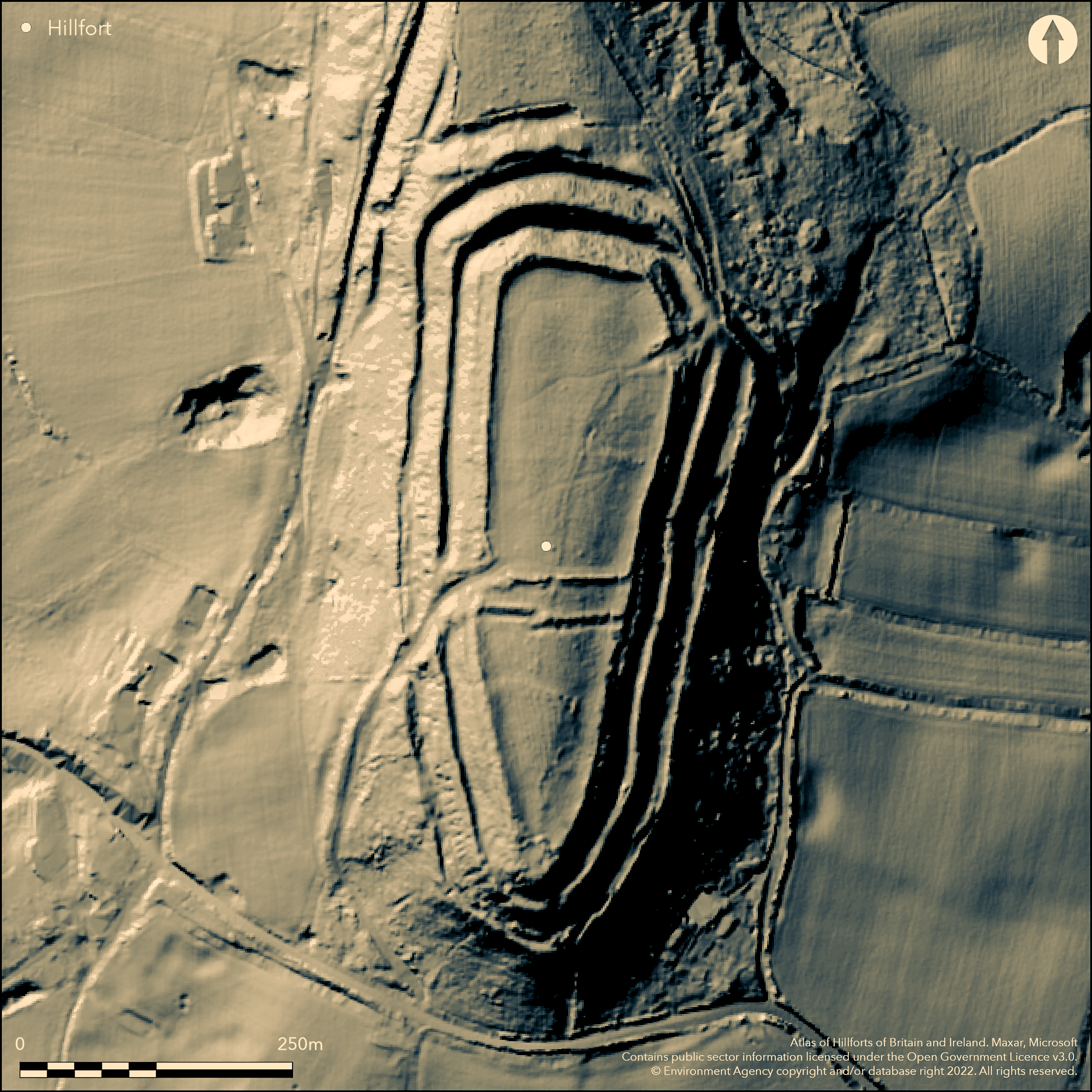
LiDAR 1m DTM Hillshade
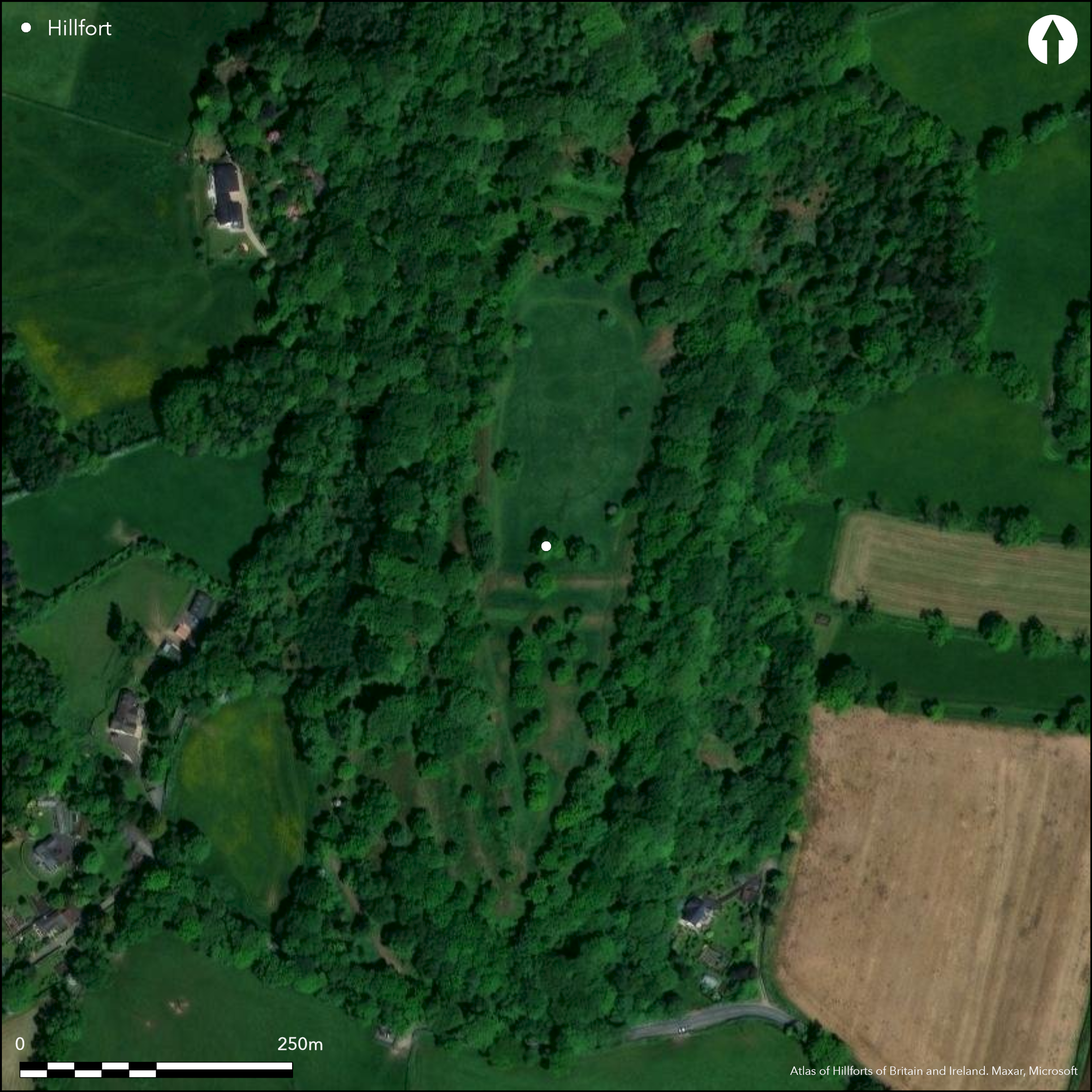
Satellite Imagery
LiDAR 1m DTM Hillshade
Satellite Imagery
Scroll left/right to view further images.
HER: Devon MDV1853 (None)
NMR: ST 10 SW 4 (188808)
SM: 1018850
NGR: ST112031
X: 311251 Y: 103099 (OSGB36)
Large, complex, multivallate contour hillfort sited at end of N-S ridge which projects to S from Blackdown Hills. Extensive views apart from to N, with sea to S. Steep surrounding slopes to E, S and W, moderate along steep sided ridge to N. The site is perhaps the most notable of all Devon hillforts and has been extensively investigated over the years. One of the few hillforts proved to have been built over a Neolithic causewayed enclosure. Elongated in plan, with internal area c. 3ha. Complex multivallation is defined by three closely-set ramparts around circuit. Ditches are difficult to ascertain, but inner rampart definite ditch to N, probably extending around circuit. Middle rampart has deep ditch to N, but indistinct to E and W. Third and outer rampart less definite feature and has break on N side where ditch and other breaks visible. Entrances near NE apex and to WSW. That to N has distinct inturns and approach from N crosses middle and outer banks obliquely. W entrance has hollow way running obliquely through all three ramparts. On S side of entrance inner bank joined by two banks in 'cross-ridge' fashion, but extensive excavations blurred matters. Excavations by D. Liddell under auspices of Devon Archaeological Exploration Society 1930-35 and M. Todd 1980-83. Both Liddell and Todd revealed Neolithic features, including earlier causewayed enclosure, series of hearths and pits and Neolithic ditches. Second Neolithic earthwork lay to N. Very extensive Early Neolithic assemblage, including 15+ partial greenstone axes, leaf arrowheads and pottery. Later C14 dates of Neolithic material 3690-3655 cal BC (68%) and 3630-3605 cal BC (68%); but C14 of hearth from Liddell's suggested Neolithic structure outside inner rampart at W entrance calibrated to 790-410 BC (95%) and 840-780 BC (95%). Iron Age finds less, with Glastonbury Ware, but Todd section at NE inner rampart showed box construction, timber revetted front and rear, of mid first millennium BC. Later this replaced by dump rampart c. first century BC. fort abandoned c. late first century BC until Roman conquest when N part of fort site of brief Roman military occupation, c. 50-60 AD, with timber buildings and W gate rebuilt. From medieval to 19th century site of annual St. Andrew's Day fair. The complex of enclosures resembles those at Hambledon Hill in Dorset (Atlas No. 3399). Sited within woodland/grassy areas with rough grass and scrub to interior and wooded banks and surrounds with some large trees, bracken and other scrub. Well-preserved with outstanding ramparts despite dense vegetation in parts. On 1st Ed. OS map (1889).
Citizen Science: ✗
Reliability of Data: Confirmed
Reliability of Interpretation: Confirmed
X: -363049 Y: 6589612 (EPSG: 3857)
Longitude: -3.2613227999237115 Latitude: 50.82054736111518 (EPSG:4326)
Country: England; None
Current County or Unitary Authority: Devon
Historic County: Devon
Current Parish/Community/Council/Townland: Payhembury; Awliscombe
Well-preserved with outstanding ramparts despite dense vegetation in parts. Impressive ramparts to 25m high on N and E sides. On Heritage at Risk Register (2015).
| Extant | ✓ |
| Cropmark | ✗ |
| Likely Destroyed | ✗ |
Sited within woodland/grassy areas with rough grass and scrub to interior and wooded banks and surrounds with some large trees, bracken and other scrub.
| Woodland | ✓ |
| Commercial Forestry Plantation | ✗ |
| Parkland | ✗ |
| Pasture (Grazing) | ✓ |
| Arable | ✗ |
| Scrub/Bracken | ✓ |
| Bare Outcrop | ✗ |
| Heather/Moorland | ✗ |
| Heath | ✗ |
| Built-up | ✗ |
| Coastal Grassland | ✗ |
| Other | ✗ |
Large, complex, multivallate contour hillfort sited at end of N-S ridge which projects to S from Blackdown Hills. Extensive views apart from to N, with sea to S. Steep surrounding slopes to E, S and W, moderate along steep sided ridge to N.
| Contour Fort | ✓ |
| Partial Contour Fort | ✗ |
| Promontory Fort | ✗ |
| Hillslope Fort | ✗ |
| Level Terrain Fort | ✗ |
| Marsh Fort | ✗ |
| Multiple Enclosure Fort | ✗ |
| Hilltop | ✓ |
| Coastal Promontory | ✗ |
| Inland Promontory | ✗ |
| Valley Bottom | ✗ |
| Knoll/Hillock/Outcrop | ✗ |
| Ridge | ✗ |
| Cliff/Plateau-edge/Scarp | ✗ |
| Hillslope | ✗ |
| Lowland | ✗ |
| Spur | ✗ |
Dominant Topographic Feature: Hill top
| North | ✗ |
| Northeast | ✗ |
| East | ✗ |
| Southeast | ✗ |
| South | ✗ |
| Southwest | ✗ |
| West | ✗ |
| Northwest | ✗ |
| Level | ✓ |
Altitude: 270.0m
Boundary Type: Parish/Townland
Very extensive Early Neolithic assemblage, including 15+ partial greenstone axes, leaf arrowheads and pottery. Later C14 dates of Neolithic material 3690-3655 cal BC (68%) and 3630-3605 cal BC (68%); but C14 of hearth from Liddell's suggested Neolithic structure outside inner rampart at W entrance calibrated to 790-410 BC (95%) and 840-780 BC (95%). Few Bronze Age artefacts, apart from three barbed and tanged arrowheads. Iron Age finds less, but Todd section at NE inner rampart showed box construction, timber revetted front and rear, of mid first millennium BC. Later this replaced by dump rampart c. first century BC. fort abandoned c. late first century BC until Roman conquest when N part of fort site of brief Roman military occupation, c 50-60 AD, with timber buildings and W gate rebuilt. In alter medieval to nineteenth century site of annual St. Andrew's Day fair.
Reliability: B - Medium
| Pre 1200BC | ✗ |
| 1200BC - 800BC | ✓ |
| 800BC - 400BC | ✓ |
| 400BC - AD50 | ✓ |
| AD50 - AD400 | ✗ |
| AD400 - AD 800 | ✗ |
| Post AD800 | ✗ |
| Unknown | ✗ |
| Pre Hillfort: | None |
| Post Hillfort: | None |
| Artefactual: | Lithics and pottery. |
| C14: | Neolithic to middle Iron Age dates. |
On 1st Ed. OS map (1889). Excavations under auspices of Devon Archaeological Exploration Society by Dorothy Liddell 1930-35. Excavations by Malcolm Todd 1980-83.
| 1st Identified Map Depiction (1889): | OS map. |
| Other (1972): | Visited by Hillfort Study Group |
| Other (2013): | Visited by Hillfort Study Group |
| Excavation (None): | D. Liddell. |
| Excavation (None): | M. Todd. |
Part of roundhouse excavated close to E rampart. Very extensive Early Neolithic assemblage, including 15+ partial greenstone axes, leaf arrowheads and pottery. Three barbed and tanged arrowheads. Iron Age Glastonbury Ware.
None
| None | ✓ |
| Spring | ✗ |
| Stream | ✗ |
| Pool | ✗ |
| Flush | ✗ |
| Well | ✗ |
| Other | ✗ |
None
| No Known Features | ✓ |
| Round Stone Structures | ✗ |
| Rectangular Stone Structures | ✗ |
| Curvilinear Platforms | ✗ |
| Other Roundhouse Evidence | ✗ |
| Pits | ✗ |
| Quarry Hollows | ✗ |
| Other | ✗ |
Part of roundhouse excavated close to E rampart. Neolithic pits of causewayed enclosure.
| No Known Excavation | ✗ |
| Pits | ✗ |
| Postholes | ✗ |
| Roundhouses | ✓ |
| Rectangular Structures | ✗ |
| Roads/Tracks | ✗ |
| Quarry Hollows | ✗ |
| Other | ✗ |
| Nothing Found | ✗ |
None
| No Known Geophysics | ✓ |
| Pits | ✗ |
| Roundhouses | ✗ |
| Rectangular Structures | ✗ |
| Roads/Tracks | ✗ |
| Quarry Hollows | ✗ |
| Other | ✗ |
| Nothing Found | ✗ |
Very extensive Early Neolithic assemblage, including 15+ partial greenstone axes, leaf arrowheads and pottery. Three barbed and tanged arrowheads. Iron Age Glastonbury Ware.
| No Known Finds | ✗ |
| Pottery | ✓ |
| Metal | ✗ |
| Metalworking | ✗ |
| Human Bones | ✗ |
| Animal Bones | ✗ |
| Lithics | ✓ |
| Environmental | ✗ |
| Other | ✗ |
None
| APs Not Checked | ✓ |
| None | ✗ |
| Roundhouses | ✗ |
| Rectangular Structures | ✗ |
| Pits | ✗ |
| Postholes | ✗ |
| Roads/Tracks | ✗ |
| Other | ✗ |
Entrances near NE apex and to WSW. That to N has distinct inturns and approach from N crosses middle and outer banks obliquely. W entrance has hollow way which runs obliquely through all, three ramparts. On S side of entrance inner bank joined by two banks in 'cross-ridge' fashion, but extensive excavations have blurred matters here.
| 2: | None |
| 2: | None |
Guard Chambers: ✗
Chevaux de Frise: ✗
| 1. In-turned (North east): | None |
| 1. Oblique (North east): | None |
| 2. Hollow Way (West): | None |
| 2. Oblique (West): | None |
The complex multivallation is defined by three closely-set ramparts around the circuit. Ditches are difficult to ascertain, but inner rampart has definite ditch to N, probably extending around the circuit. Middle rampart has deep ditch to N, but indistinct to E and W. The third and outer rampart is a less definite feature and has a break on its N side where there is a ditch and other breaks visible.
| Area 1: | 3.0ha. |
| Total: | 3.0ha. |
Total Footprint Area: Noneha.
None
| ✗ | None |
| ✓ | None |
| NE Quadrant: | 3 |
| SE Quadrant: | 3 |
| SW Quadrant: | 3 |
| NW Quadrant: | 3 |
| Total: | 3 |
| Partial Univallate | ✗ |
| Univallate | ✗ |
| Partial Bivallate | ✗ |
| Bivallate | ✗ |
| Partial Multivallate | ✗ |
| Multivallate | ✓ |
| Unknown | ✗ |
| Partial Univallate | ✗ |
| Univallate | ✗ |
| Partial Bivallate | ✗ |
| Bivallate | ✗ |
| Partial Multivallate | ✗ |
| Multivallate | ✗ |
None
| None | ✗ |
| Earthen Bank | ✓ |
| Stone Wall | ✗ |
| Rubble | ✗ |
| Wall-walk | ✗ |
| Evidence of Timber | ✗ |
| Vitrification | ✗ |
| Other Burning | ✗ |
| Palisade | ✗ |
| Counter Scarp Bank | ✗ |
| Berm | ✗ |
| Unfinished | ✗ |
| Other | ✗ |
Box rampart and palisade trench back and front.
| None | ✗ |
| Earthen Bank | ✓ |
| Stone Wall | ✗ |
| Murus Duplex | ✗ |
| Timber-framed | ✓ |
| Timber-laced | ✗ |
| Vitrification | ✗ |
| Other Burning | ✗ |
| Palisade | ✓ |
| Counter Scarp Bank | ✗ |
| Berm | ✗ |
| Unfinished | ✗ |
| No Known Excavation | ✗ |
| Other | ✓ |
| ✗ | None |
| ✓ | At least two. |
Number of Ditches: 2
| ✗ | None |
Griffith, F.M. and Wilkes, E.M. 2011. In the footsteps of pioneering women: some recent work on Devon hillforts, In Pearce, S (ed). Recent archaeological work in South-Western Britain, BAR British Series 548.
Liddell, D.M. Report on the excavations at Hembury Fort, Proc Devon Archaeol Ex Soc, I (1930), 1-24; I (1931), 90-120, 162-90; II (1935), 135-75.
Todd, M. 1985. Excavations at Hembury (Devon) 1980-1983, Antiq J, 64, 251-68.
Todd, M. 1989. Hembury, Field Guide Number Five, Devon Archaeological Society.
Todd, M. 1987. The South West to AD 1000, London.
Todd, M. 2002. The cross-dykes at Hembury, Proc Devon Archaeol Soc, 60, 207-210.
Todd, M. 2007. Roman military occupation at Hembury (Devon), Britannia, 38, 107-123.
Atlas of Hillforts:
Wikidata:
This work is licensed under CC BY-SA 4.0

 and should be cited as:
Lock, Gary and Ralston, Ian. 2024. Atlas of Hillforts of Britain and Ireland. Available at: https://hillforts.arch.ox.ac.uk
Document Version 1.1