
LiDAR 1m DTM Hillshade
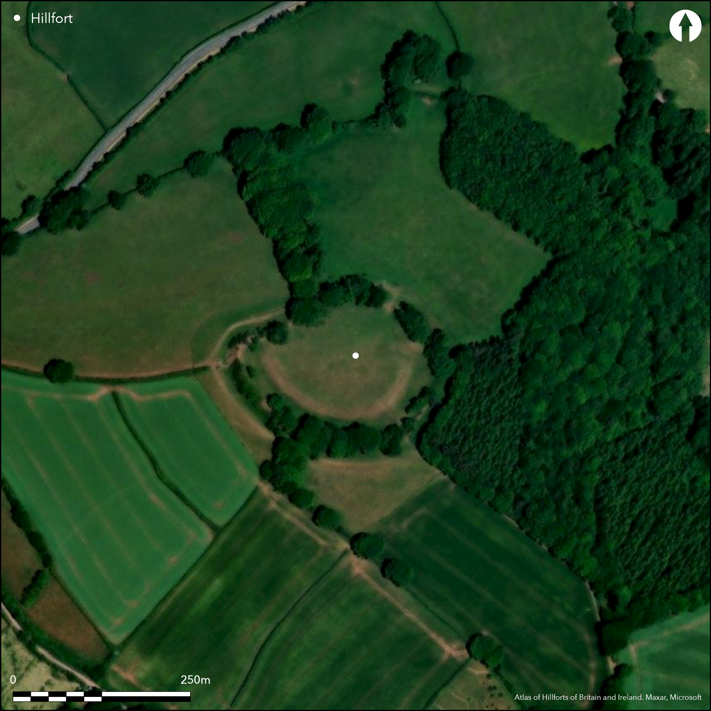
Satellite Imagery
LiDAR 1m DTM Hillshade
Satellite Imagery
Scroll left/right to view further images.
HER: Devon MDV1213 (None)
NMR: SS 90 NW 1 (36328)
SM: 1019540
NGR: SS913052
X: 291343 Y: 105284 (OSGB36)
A commanding contour hillfort located on summit of prominent hill overlooking valley of The Burn and three tributaries of River Exe. Steep surrounding slopes. Oval shaped, with interior c. 1.6ha. Massive ramparts with Phase 1 bank, to 3m high externally, and outer ditch, to which second rampart, to 2.2m high externally, and ditch added as Phase 2 to E, S and W sides. Beyond these to S is further outer bank to 0.6m high externally which peters out to E and W. Inner Phase I enclosure measures c. 120m E-W by 95m internally. Inturned entrance to inner and original enclosure on E side facing SE. Entrance to Phase 2 on SE with inturn on W side and blocking of original ditch inside so forcing those entering site to turn right and follow the ditch and enter inner enclosure finally through original Phase I entrance. The flat curving area between two rampart phases c. 12.9m wide. No excavations as such, but landowner emptied possible ritual shaft or well in interior c. 17m deep, possibly dated to c. 4th century AD in c. 1848. This produced assemblage of c. 24 4th century AD copper alloy bracelets, shale bracelet fragments, beads, finger rings and 4th century AD pottery. 3rd century AD coin hoard also found. Geophysical survey commissioned from E.M. Wilkes, Bournemouth University, prior to Stewardship scheme finding possible round houses and new outer ditch on S side, possibly result of Civil War occupation by Fairfax in winter of 1645-46. 17th century sword found. Well-preserved massive banks, but heavily ploughed interior masks any features. Improved pasture. Some scrub and trees on banks. On 1st Ed. OS map (1889). Undated.
Citizen Science: ✗
Reliability of Data: Confirmed
Reliability of Interpretation: Confirmed
X: -394572 Y: 6592475 (EPSG: 3857)
Longitude: -3.5444973228699115 Latitude: 50.836792473765016 (EPSG:4326)
Country: England
Current County or Unitary Authority: Devon
Historic County: Devon
Current Parish/Community/Council/Townland: Cadbury
Well-preserved massive banks, but heavily ploughed interior masks any features.
| Extant | ✓ |
| Cropmark | ✗ |
| Likely Destroyed | ✗ |
Improved pasture. Scrub and trees on banks. Field boundary tree line to NNW.
| Woodland | ✗ |
| Commercial Forestry Plantation | ✗ |
| Parkland | ✗ |
| Pasture (Grazing) | ✓ |
| Arable | ✗ |
| Scrub/Bracken | ✓ |
| Bare Outcrop | ✗ |
| Heather/Moorland | ✗ |
| Heath | ✗ |
| Built-up | ✗ |
| Coastal Grassland | ✗ |
| Other | ✗ |
Univallate contour hillfort located on summit of prominent hill overlooking valley of The Burn and three tributaries of River Exe. Steep surrounding slopes.
| Contour Fort | ✓ |
| Partial Contour Fort | ✗ |
| Promontory Fort | ✗ |
| Hillslope Fort | ✗ |
| Level Terrain Fort | ✗ |
| Marsh Fort | ✗ |
| Multiple Enclosure Fort | ✗ |
| Hilltop | ✓ |
| Coastal Promontory | ✗ |
| Inland Promontory | ✗ |
| Valley Bottom | ✗ |
| Knoll/Hillock/Outcrop | ✗ |
| Ridge | ✗ |
| Cliff/Plateau-edge/Scarp | ✗ |
| Hillslope | ✗ |
| Lowland | ✗ |
| Spur | ✗ |
Dominant Topographic Feature: Hill top
| North | ✗ |
| Northeast | ✗ |
| East | ✗ |
| Southeast | ✗ |
| South | ✗ |
| Southwest | ✗ |
| West | ✗ |
| Northwest | ✗ |
| Level | ✓ |
Altitude: 253.0m
N/A
Date of hillfort unknown, but 4th century AD pottery from shaft suggest later Roman interest in site if not re-use..
Reliability: D - None
| Pre 1200BC | ✗ |
| 1200BC - 800BC | ✗ |
| 800BC - 400BC | ✗ |
| 400BC - AD50 | ✗ |
| AD50 - AD400 | ✗ |
| AD400 - AD 800 | ✗ |
| Post AD800 | ✗ |
| Unknown | ✓ |
| Pre Hillfort: | None |
| Post Hillfort: | 4th century AD pottery from shaft. Site occupied by Fairfax in winter 1645-46. |
| Artefactual: | Pottery. |
On 1st Ed. OS map (1889). Shaft emptied c. 1848. On 1st Ed. OS map (1889). Geophysical survey commissioned from E.M. Wilkes, Bournemouth University, prior to Stewardship scheme 2013.
| Other (1848): | Shaft emptied. |
| 1st Identified Map Depiction (1889): | OS map. |
| Geophysical Survey (2013): | Commissioned from E.M. Wilkes, Bournemouth University, prior to Stewardship scheme. |
| Other (2013): | Visited by Hillfort Study Group |
Geophysical survey found possible roundhouses in interior. Assemblage of c. 24 fourth century AD copper alloy bracelets, shale bracelet fragments, finger rings, beads and fourth century AD pottery from shaft. Third century AD coin hoard. 17th century sword found.
None
| None | ✓ |
| Spring | ✗ |
| Stream | ✗ |
| Pool | ✗ |
| Flush | ✗ |
| Well | ✗ |
| Other | ✗ |
None
| No Known Features | ✓ |
| Round Stone Structures | ✗ |
| Rectangular Stone Structures | ✗ |
| Curvilinear Platforms | ✗ |
| Other Roundhouse Evidence | ✗ |
| Pits | ✗ |
| Quarry Hollows | ✗ |
| Other | ✗ |
Shaft emptied 1848 with finds.
| No Known Excavation | ✗ |
| Pits | ✗ |
| Postholes | ✗ |
| Roundhouses | ✗ |
| Rectangular Structures | ✗ |
| Roads/Tracks | ✗ |
| Quarry Hollows | ✗ |
| Other | ✓ |
| Nothing Found | ✗ |
Possible roundhouses in interior.
| No Known Geophysics | ✗ |
| Pits | ✗ |
| Roundhouses | ✓ |
| Rectangular Structures | ✗ |
| Roads/Tracks | ✗ |
| Quarry Hollows | ✗ |
| Other | ✗ |
| Nothing Found | ✗ |
Assemblage of c. 24 4th century AD copper alloy bracelets, shale bracelet fragments, beads, finger rings and 4th century AD pottery from shaft. 3rd century AD coin hoard. 17th century sword found.
| No Known Finds | ✗ |
| Pottery | ✓ |
| Metal | ✓ |
| Metalworking | ✗ |
| Human Bones | ✗ |
| Animal Bones | ✗ |
| Lithics | ✗ |
| Environmental | ✗ |
| Other | ✓ |
None
| APs Not Checked | ✓ |
| None | ✗ |
| Roundhouses | ✗ |
| Rectangular Structures | ✗ |
| Pits | ✗ |
| Postholes | ✗ |
| Roads/Tracks | ✗ |
| Other | ✗ |
Inturned entrance to inner and original enclosure on E side facing SE. Entrance to Phase 2 on SE with inturn on W side and blocking of original ditch inside so forcing those entering site to turn right and follow the ditch and enter inner enclosure finally through original Phase I entrance.
| 2: | None |
| 2: | None |
Guard Chambers: ✗
Chevaux de Frise: ✗
| 1. In-turned (East): | Faces SE. |
| 2. In-turned (South east): | None |
Massive ramparts with Phase 1 bank, to 3m high externally, and outer ditch, to which second rampart, to 2.2m high externally, and ditch added as Phase 2 to E, S and W sides. Beyond these to S is further outer bank to 0.6m high externally which peters out to E and W. Geophysical survey found segmented structure of inner rampart and marked kink at junctions of Phase I and 2 banks.
| Area 1: | 1.6ha. |
| Total: | 1.6ha. |
Total Footprint Area: Noneha.
None
| ✓ | Two phases determined by Lady Fox (Fox 1996). |
| ✓ | None |
| NE Quadrant: | 1 |
| SE Quadrant: | 3 |
| SW Quadrant: | 3 |
| NW Quadrant: | 2 |
| Total: | 3 |
| Partial Univallate | ✓ |
| Univallate | ✗ |
| Partial Bivallate | ✓ |
| Bivallate | ✗ |
| Partial Multivallate | ✓ |
| Multivallate | ✗ |
| Unknown | ✗ |
| Partial Univallate | ✗ |
| Univallate | ✓ |
| Partial Bivallate | ✗ |
| Bivallate | ✗ |
| Partial Multivallate | ✗ |
| Multivallate | ✗ |
Geophysical survey found segmented structure of inner rampart and marked kink at junctions of Phase I and 2 banks.
| None | ✗ |
| Earthen Bank | ✓ |
| Stone Wall | ✗ |
| Rubble | ✗ |
| Wall-walk | ✗ |
| Evidence of Timber | ✗ |
| Vitrification | ✗ |
| Other Burning | ✗ |
| Palisade | ✗ |
| Counter Scarp Bank | ✗ |
| Berm | ✗ |
| Unfinished | ✗ |
| Other | ✓ |
No excavation of ramparts - shaft emptied.
| None | ✗ |
| Earthen Bank | ✗ |
| Stone Wall | ✗ |
| Murus Duplex | ✗ |
| Timber-framed | ✗ |
| Timber-laced | ✗ |
| Vitrification | ✗ |
| Other Burning | ✗ |
| Palisade | ✗ |
| Counter Scarp Bank | ✗ |
| Berm | ✗ |
| Unfinished | ✗ |
| No Known Excavation | ✓ |
| Other | ✗ |
| ✗ | None |
| ✓ | None |
Number of Ditches: 3
| ✗ | None |
Fox, A. 1952. Roman objects from Cadbury Castle, Rep. Trans. Devon Assoc., 84, 105-14.
Fox, A. 1996. Prehistoric hillforts in Devon, Tiverton: Devon Books.
Griffith, F.M. and Wilkes, E.M. 2011. In the footsteps of pioneering women: some recent work on Devon hillforts, In Pearce, S (ed). Recent archaeological work in South-Western Britain, BAR British Series 548.
Wilkes, E.M. 2010. Report on geophysical survey at Cadbury Camp, Devon, Unpublished client report (Natural England and Fursdon Estate), available at Devon HER.
Wilkes, E.M. and Griffith, F.M. 2013. Cadbury Castle, Devon, reconsidered, Archaeol J., 169, 237-80.
Atlas of Hillforts:
Wikidata:
This work is licensed under CC BY-SA 4.0![]()
![]()
![]() and should be cited as:
and should be cited as:
Lock, Gary and Ralston, Ian. 2024. Atlas of Hillforts of Britain and Ireland. Available at: https://hillforts.arch.ox.ac.uk
Document Version 1.1