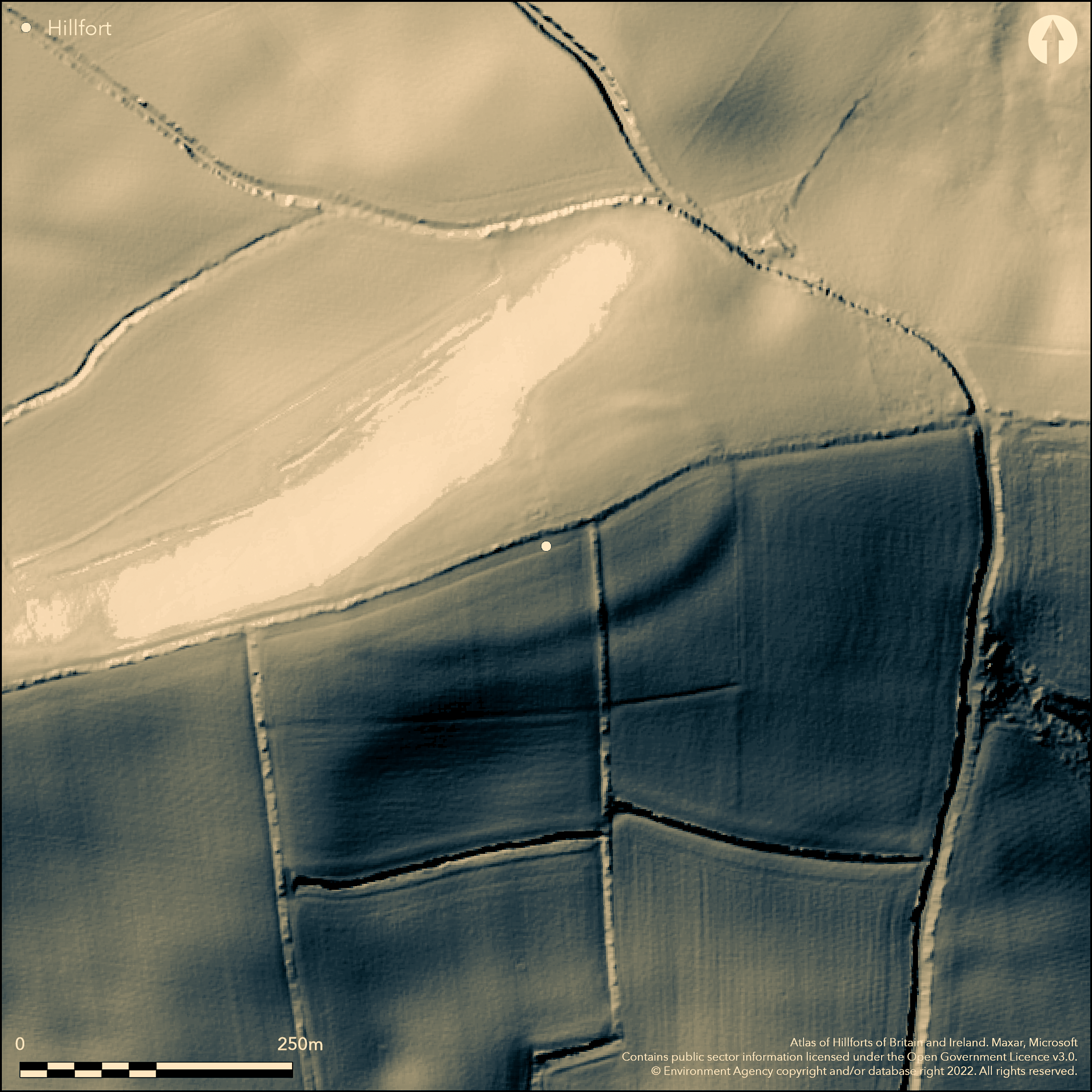
LiDAR 1m DTM Hillshade
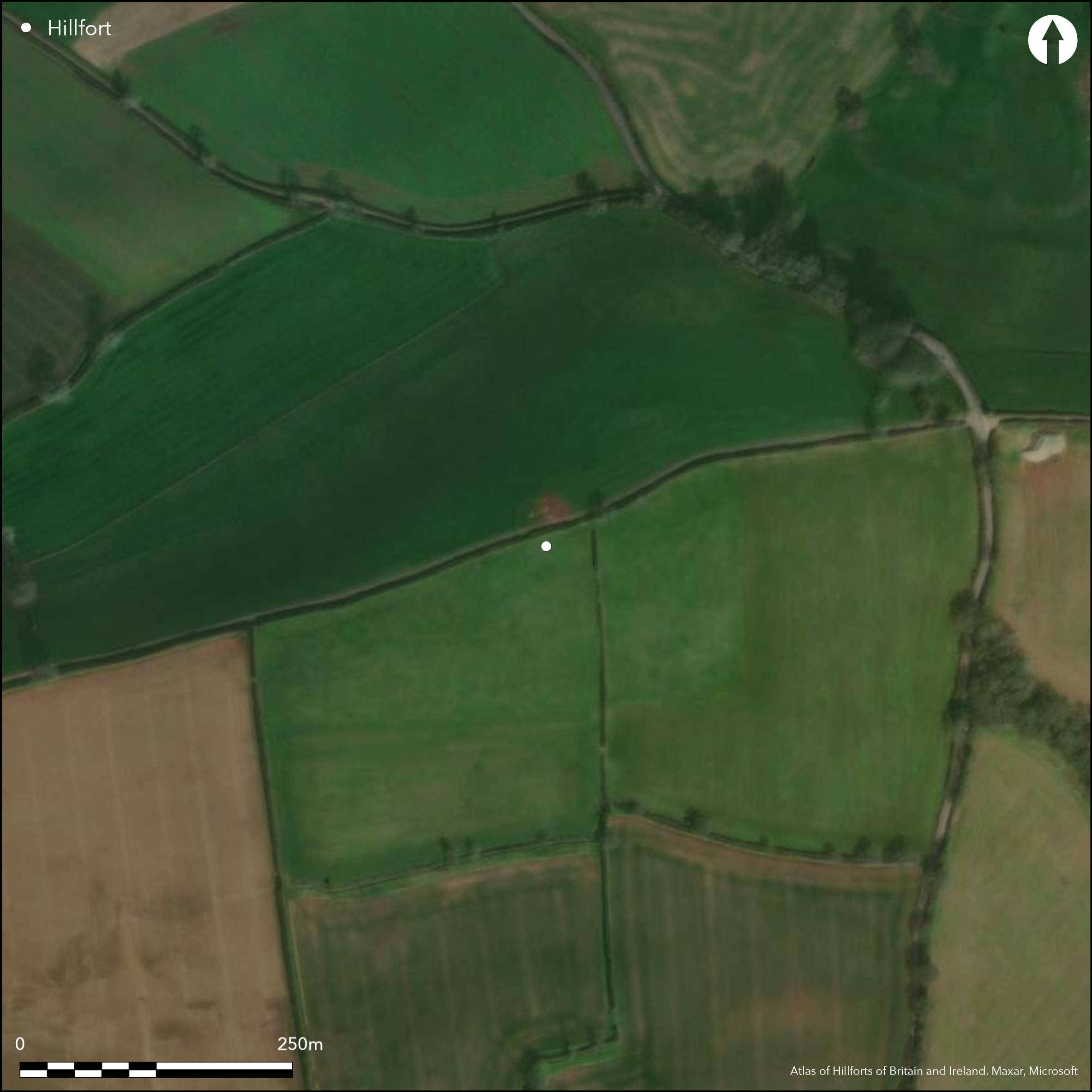
Satellite Imagery
LiDAR 1m DTM Hillshade
Satellite Imagery
Scroll left/right to view further images.
HER: Devon MDV29729 (None)
NMR: SS 80 SE 53 (1038533)
SM: 1016259
NGR: SS 8855 0315
X: 288552 Y: 103136 (OSGB36)
Contour hillfort located towards W end of Raddon Hills, overlooking lower ground between River Exe and Creedy to S. Steep surrounding slopes, very steep on N quadrants. Now cropmark. Partly overlies Neolithic causewayed enclosure. Associated field system. Intervisible with Cadbury Castle (Atlas No 3354). First identified as earthwork by F. Griffith from 1984 aerial photographs as curvilinear cropmarks, and at that time regarded as possibly geological. Interpreted by fieldwork as hillfort 1993. Small excavation 1994, with geophysical and contour surveys over wider area. Causewayed enclosure roughly oval in plan, about c. 210m E-W by 125m, enclosing c. 1.9ha of hilltop defined by ditch divided into unequal sections by causeways. Within this enclosure is another enclosure c. 115m E-W by 70m, enclosing c. 0.6ha. Within enclosures pits and postholes excavated, with Neolithic flint tools, including leaf-shaped arrowheads and scrapers, flint cores and hammerstones and polished stone axehead. Pottery fragments, similar to those from causewayed enclosure beneath Hembury hillfort, (Atlas No 3349). Later hillfort, irregular in plan c. 155m E-W by 100m, enclosing c. 1ha within a ditch. Located on W side of hillcrest, defined by low earthwork, visible as break of slope on W and S sides of alignment of outer cropmark and overlying W parts enclosed by both inner and outer ditches of causewayed enclosure. In fields on S side of fort lower part of break in hillslope has scatters of worked flint in soil. V-shaped ditch identified, 2m wide and 0.9m deep. Originally, earth rampart on inner side of circuit of ditch and foundation trench of wooden palisade, 0.5m wide and 0.3m deep, revetting face of rampart. Possible W entrance. Late Bronze Age/early Iron Age pottery fragments found, with metal working residue from W end of hillfort. Where hillfort and causewayed encloures overlap, features may be associated with either, including discontinuous circle of stakeholes c. 3m diameter, possible dwelling; two elongated pits with burnt bone and charcoal, possible graves, and vertical shaft, 5.9m diameter, excavated to 2.2m, possible upper part of a well. To NE of causewayed enclosure part of prehistoric field system identified by geophysical survey. Near centre of causewayed enclosure, underground monitoring post of the Royal Observer Corps.
Citizen Science: ✗
Reliability of Data: Confirmed
Reliability of Interpretation: Confirmed
X: -398909 Y: 6588978 (EPSG: 3857)
Longitude: -3.5834646777247303 Latitude: 50.81695232374065 (EPSG:4326)
Country: England; None
Current County or Unitary Authority: Devon
Historic County: Devon
Current Parish/Community/Council/Townland: Stockleigh Pomeroy; Shobrooke
Now cropmark. Cut by track. Near centre of causewayed enclosure, underground monitoring post of the Royal Observer Corps. On Heritage at Risk Register (2015).
| Extant | ✗ |
| Cropmark | ✓ |
| Likely Destroyed | ✓ |
Improved pasture. Near centre of causewayed enclosure, underground monitoring post of the Royal Observer Corps.
| Woodland | ✗ |
| Commercial Forestry Plantation | ✗ |
| Parkland | ✗ |
| Pasture (Grazing) | ✓ |
| Arable | ✗ |
| Scrub/Bracken | ✗ |
| Bare Outcrop | ✗ |
| Heather/Moorland | ✗ |
| Heath | ✗ |
| Built-up | ✗ |
| Coastal Grassland | ✗ |
| Other | ✓ |
Possible contour hillfort located on Raddon Hill, a hillcrest towards W end of Raddon Hills overlooking lower ground between River Exe and Creedy to S. Steep surrounding slopes, very steep on N quadrants.
| Contour Fort | ✓ |
| Partial Contour Fort | ✗ |
| Promontory Fort | ✗ |
| Hillslope Fort | ✗ |
| Level Terrain Fort | ✗ |
| Marsh Fort | ✗ |
| Multiple Enclosure Fort | ✗ |
| Hilltop | ✓ |
| Coastal Promontory | ✗ |
| Inland Promontory | ✗ |
| Valley Bottom | ✗ |
| Knoll/Hillock/Outcrop | ✗ |
| Ridge | ✗ |
| Cliff/Plateau-edge/Scarp | ✗ |
| Hillslope | ✗ |
| Lowland | ✗ |
| Spur | ✗ |
Dominant Topographic Feature: Hill top
| North | ✗ |
| Northeast | ✗ |
| East | ✗ |
| Southeast | ✗ |
| South | ✗ |
| Southwest | ✗ |
| West | ✗ |
| Northwest | ✗ |
| Level | ✓ |
Altitude: 213.0m
Boundary Type: Parish/Townland
Features, including palisades, and pottery from their enclosing ditches and trenches suggest late Bronze Age/early Iron Age date. 16 C14 dates beginning with earliest phase of Neolithic, then break till first millennium BC and further break till post-Roman period. One of very few sequences of dates determined for hillfort in Devon.
Reliability: A - High
| Pre 1200BC | ✗ |
| 1200BC - 800BC | ✗ |
| 800BC - 400BC | ✓ |
| 400BC - AD50 | ✗ |
| AD50 - AD400 | ✗ |
| AD400 - AD 800 | ✗ |
| Post AD800 | ✗ |
| Unknown | ✗ |
| Pre Hillfort: | None |
| Post Hillfort: | None |
| Artefactual: | Pottery suggest late Bronze Age/early Iron Age date. |
| C14: | Sequence from 16 C14 dates, one of very few sequences of dates determined for hillfort in Devon. |
| Morphology/Earthwork/Typology: | Palisade trenches. |
First identified as earthwork by F. Griffith from 1984 aerial photographs as curvilinear cropmarks, and at that time regarded as possibly geological. Interpreted by fieldwork as hillfort 1993. Small excavation 1994, with geophysical and contour surveys over wider area. 1992- 1996 Air Photograph Interpretation RCHME: Air Photograph Primary Recording Project. Evaluation excavations for reservoir pipe by the Exeter Museum Archaeological Field Unit 1994 and cropmarks transcribed and analysed by RCHME 1997, the latter as part of Industry and Enclosure in the Neolithic Project.
| Other (1993): | First identified as earthwork by F. Griffith from 1984 aerial photographs as curvilinear cropmarks, and at that time regarded as possibly geological. Interpreted by fieldwork as hillfort 1993. |
| Excavation (1994): | Excavations for reservoir pipe by the Exeter Museum Archaeological Field Unit 1994. |
| Geophysical Survey (1994): | Oxford Archaeotechnics. |
| Earthwork Survey (1994): | Oxford Archaeotechnics. |
| Other (1997): | Cropmarks transcribed and analysed by RCHME 1997, the latter as part of Industry and Enclosure in the Neolithic Project. |
| Other (None): | Air Photograph Interpretation RCHME: Air Photograph Primary Recording Project. |
Pits and postholes from excavation. Where hillfort and causewayed encloures overlap, features may be associated with either, including discontinuous circle of stakeholes c. 3m diameter, possible dwelling; two elongated pits with burnt bone and charcoal, possible graves, and vertical shaft, 5.9m diameter, excavated to 2.2m, possible upper part of a well. Late Bronze Age/early Iron Age pottery fragments found, with metal working residue from W end of hillfort.
None
| None | ✓ |
| Spring | ✗ |
| Stream | ✗ |
| Pool | ✗ |
| Flush | ✗ |
| Well | ✗ |
| Other | ✗ |
None
| No Known Features | ✓ |
| Round Stone Structures | ✗ |
| Rectangular Stone Structures | ✗ |
| Curvilinear Platforms | ✗ |
| Other Roundhouse Evidence | ✗ |
| Pits | ✗ |
| Quarry Hollows | ✗ |
| Other | ✗ |
Pits and postholes from excavation. Where hillfort and causewayed encloures overlap, features may be associated with either, including discontinuous circle of stakeholes c. 3m diameter, possible dwelling; two elongated pits with burnt bone and charcoal, possible graves, and vertical shaft, 5.9m diameter, excavated to 2.2m, possible upper part of a well.
| No Known Excavation | ✗ |
| Pits | ✓ |
| Postholes | ✓ |
| Roundhouses | ✓ |
| Rectangular Structures | ✗ |
| Roads/Tracks | ✗ |
| Quarry Hollows | ✗ |
| Other | ✓ |
| Nothing Found | ✗ |
None
| No Known Geophysics | ✗ |
| Pits | ✗ |
| Roundhouses | ✗ |
| Rectangular Structures | ✗ |
| Roads/Tracks | ✗ |
| Quarry Hollows | ✗ |
| Other | ✗ |
| Nothing Found | ✓ |
Late Bronze Age/early Iron Age pottery fragments found, with metal working residue from W end of hillfort. Burnt bone and charcoal.
| No Known Finds | ✗ |
| Pottery | ✓ |
| Metal | ✗ |
| Metalworking | ✓ |
| Human Bones | ✗ |
| Animal Bones | ✗ |
| Lithics | ✗ |
| Environmental | ✓ |
| Other | ✗ |
None
| APs Not Checked | ✓ |
| None | ✗ |
| Roundhouses | ✗ |
| Rectangular Structures | ✗ |
| Pits | ✗ |
| Postholes | ✗ |
| Roads/Tracks | ✗ |
| Other | ✗ |
Possible W entrance.
| 1: | Estimated. |
| 2: | Estimated. |
Guard Chambers: ✗
Chevaux de Frise: ✗
| 1. Simple Gap (West): | Type estimated. |
Located on W side of hillcrest, defined by low earthwork, visible as break of slope on W and S sides of alignment of outer cropmark and overlying W parts enclosed by both inner and outer ditches of causewayed enclosure. In fields on S side of fort lower part of break in hillslope has scatters of worked flint in soil. V-shaped ditch identified, 2m wide and 0.9m deep. Originally, earth rampart on inner side of circuit of ditch and foundation trench of wooden palisade, 0.5m wide and 0.3m deep, revetting face of rampart.
| Area 1: | 1.0ha. |
| Total: | 1.0ha. |
Total Footprint Area: Noneha.
None
| ✗ | None |
| ✗ | Suggested by ditch |
| NE Quadrant: | None |
| SE Quadrant: | None |
| SW Quadrant: | 1 |
| NW Quadrant: | None |
| Total: | 1 |
| Partial Univallate | ✓ |
| Univallate | ✗ |
| Partial Bivallate | ✗ |
| Bivallate | ✗ |
| Partial Multivallate | ✗ |
| Multivallate | ✗ |
| Unknown | ✗ |
| Partial Univallate | ✗ |
| Univallate | ✗ |
| Partial Bivallate | ✗ |
| Bivallate | ✗ |
| Partial Multivallate | ✗ |
| Multivallate | ✗ |
Cropmark just visible as break of slope.
| None | ✗ |
| Earthen Bank | ✗ |
| Stone Wall | ✗ |
| Rubble | ✗ |
| Wall-walk | ✗ |
| Evidence of Timber | ✗ |
| Vitrification | ✗ |
| Other Burning | ✗ |
| Palisade | ✗ |
| Counter Scarp Bank | ✗ |
| Berm | ✗ |
| Unfinished | ✗ |
| Other | ✓ |
Originally, earth rampart on inner side of circuit of ditch and foundation trench of wooden palisade, 0.5m wide and 0.3m deep, revetting face of rampart.
| None | ✗ |
| Earthen Bank | ✓ |
| Stone Wall | ✗ |
| Murus Duplex | ✗ |
| Timber-framed | ✗ |
| Timber-laced | ✗ |
| Vitrification | ✗ |
| Other Burning | ✗ |
| Palisade | ✓ |
| Counter Scarp Bank | ✗ |
| Berm | ✗ |
| Unfinished | ✗ |
| No Known Excavation | ✗ |
| Other | ✗ |
| ✗ | None |
| ✓ | V-shaped ditch identified by excavation, 2m wide and 0.9m deep. |
Number of Ditches: 1
| ✗ | None |
Gent, T. and Quinnell, H. 1999. Excavation of a causewayed enclosure and hillfort on Raddon Hill, Stockleigh Pomeroy, Proc. Devon Archaeol. Soc, 57, 1-75.
Griffith, F.M. and Wilkes, E.M. 2011. In the footsteps of pioneering women: some recent work on Devon hillforts, In Pearce, S (ed). Recent archaeological work in South-Western Britain, BAR British Series 548.
Knight, M and Gent, T. 1994. Excavation and Survey of a multi-period enclosure at Raddon Hill, Exeter: Exeter Museums Archaeological Field Unit Report.
Johnson, A.E. 1995. Raddon Hill, Stockleigh Pomeroy, Devon. Geophysical and topographic surveys: Interim report, No. 0420594/RAD/EXM, Oxford Archaeotechnics.
Atlas of Hillforts:
Wikidata:
This work is licensed under CC BY-SA 4.0

 and should be cited as:
Lock, Gary and Ralston, Ian. 2024. Atlas of Hillforts of Britain and Ireland. Available at: https://hillforts.arch.ox.ac.uk
Document Version 1.1