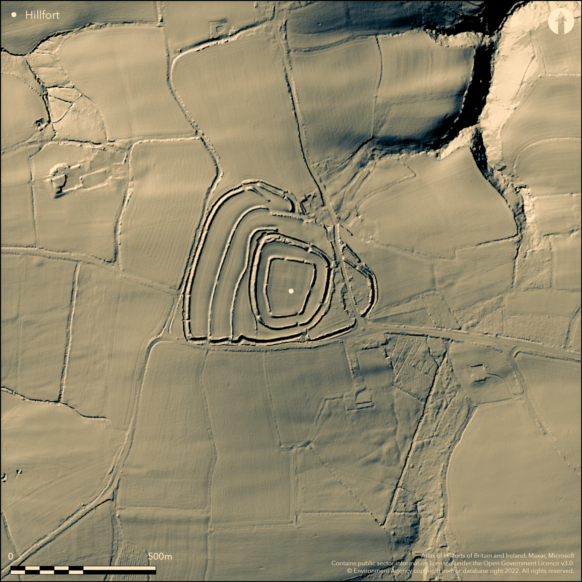
LiDAR 1m DTM Hillshade
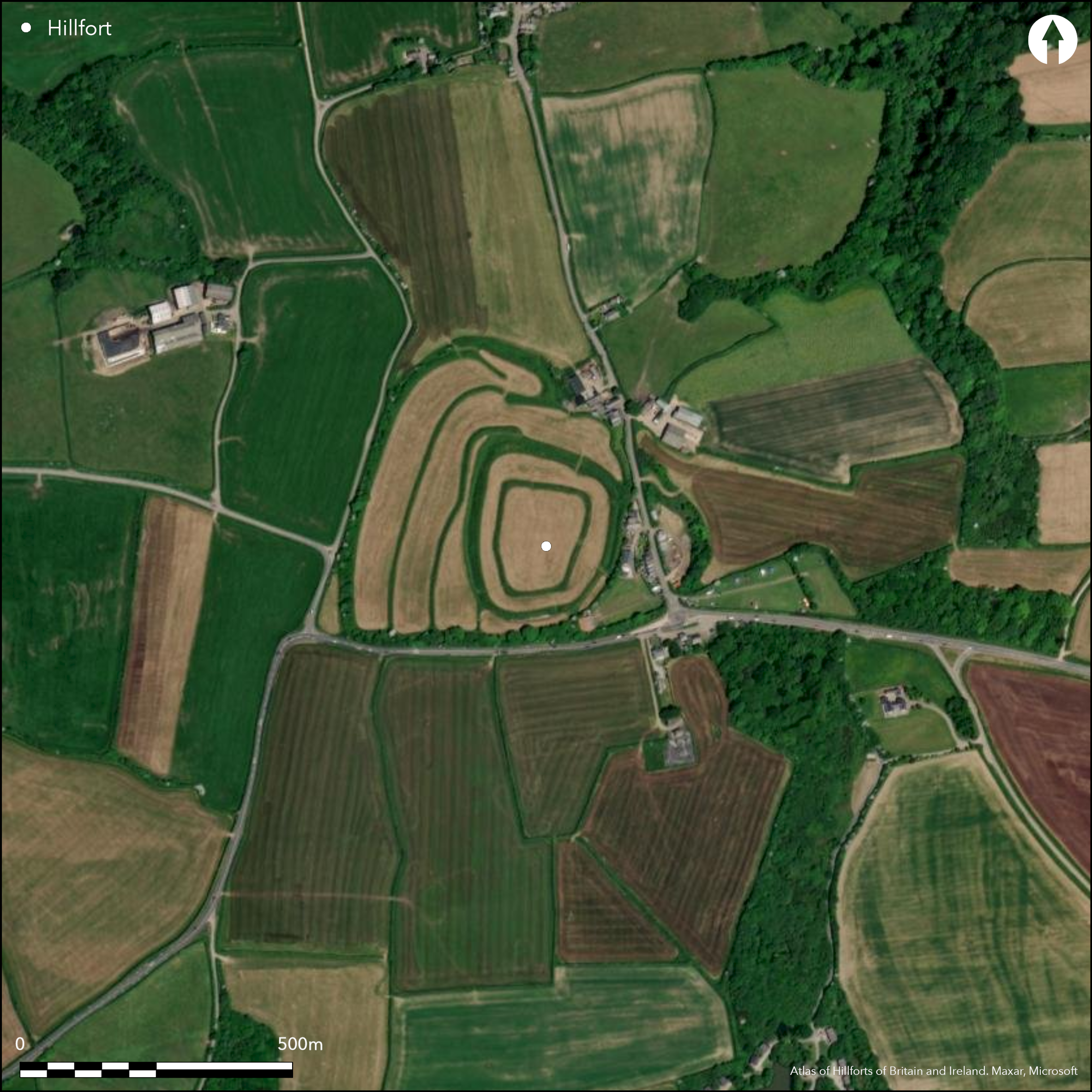
Satellite Imagery
LiDAR 1m DTM Hillshade
Satellite Imagery
Scroll left/right to view further images.
HER: Devon MDV169 (None)
NMR: SS 32 SW 1 (32663)
SM: 1018522
NGR: SS311234
X: 231154 Y: 123437 (OSGB36)
Large multiple enclosure hillfort located on high upland plateau overlooking Bideford Bay and commanding far reaching views in all directions and to sea to N. Only 1km from sea and at point where three ridgeway routes meet. Moderate surrounding slopes. Site defined by complex series of enclosures, with banks and ditches suggesting several phases of development. Sub-rectangular inner enclosure with rampart to c. 2.1m high, ditch buried feature enclosing 1.1ha. Entrance to E. Second enclosure concentric to first with rampart to c. 3m high and outer ditch to c. 3.5m deep enclosing 2.7ha. Entrances to E and SE. Outer enclosure roughly triangular with steep rampart to c. 3m high enclosing 9.1ha. Outer ditch buried feature to E and S, but to c. 3m deep on N and W. Curving overlapped entrance to N. Within outer enclosure the hillfort subdivided by two smaller ramparts running c. N-S on W side, the banks to c. 2.5m and accompanying ditches both buried features. Site much affected by development, with large farm and buildings cutting into outer rampart and ditch on E. Large number of modern structures and features and buildings. However despite this agricultural activity and other developments survives well and one of the most impressive hillforts in Devon. On 1st Ed. OS map (1886). Minimal investigations, undated.
Citizen Science: ✗
Reliability of Data: Confirmed
Reliability of Interpretation: Confirmed
X: -490588 Y: 6618721 (EPSG: 3857)
Longitude: -4.40702270019406 Latitude: 50.985454251772346 (EPSG:4326)
Country: England
Current County or Unitary Authority: Devon
Historic County: Devon
Current Parish/Community/Council/Townland: Clovelly
Rampart and ditch damaged by farm and associated buildings on E. On Heritage at Risk Register (2015).
| Extant | ✓ |
| Cropmark | ✗ |
| Likely Destroyed | ✓ |
Improved pasture.
| Woodland | ✗ |
| Commercial Forestry Plantation | ✗ |
| Parkland | ✗ |
| Pasture (Grazing) | ✓ |
| Arable | ✗ |
| Scrub/Bracken | ✗ |
| Bare Outcrop | ✗ |
| Heather/Moorland | ✗ |
| Heath | ✗ |
| Built-up | ✓ |
| Coastal Grassland | ✗ |
| Other | ✗ |
Large and commanding multiple enclosure hillfort located on high upland plateau overlooking Bideford Bay and commanding far reaching views in all directions and to sea to N. Strategic position only 1km from sea and at point where three ridgeway routes meet. Moderate surrounding slopes.
| Contour Fort | ✗ |
| Partial Contour Fort | ✗ |
| Promontory Fort | ✗ |
| Hillslope Fort | ✗ |
| Level Terrain Fort | ✗ |
| Marsh Fort | ✗ |
| Multiple Enclosure Fort | ✓ |
| Hilltop | ✓ |
| Coastal Promontory | ✗ |
| Inland Promontory | ✗ |
| Valley Bottom | ✗ |
| Knoll/Hillock/Outcrop | ✗ |
| Ridge | ✗ |
| Cliff/Plateau-edge/Scarp | ✓ |
| Hillslope | ✗ |
| Lowland | ✗ |
| Spur | ✗ |
Dominant Topographic Feature: Hill top plateau.
| North | ✗ |
| Northeast | ✗ |
| East | ✗ |
| Southeast | ✗ |
| South | ✗ |
| Southwest | ✗ |
| West | ✗ |
| Northwest | ✗ |
| Level | ✓ |
Altitude: 210.0m
N/A
None
Reliability: D - None
| Pre 1200BC | ✗ |
| 1200BC - 800BC | ✗ |
| 800BC - 400BC | ✗ |
| 400BC - AD50 | ✗ |
| AD50 - AD400 | ✗ |
| AD400 - AD 800 | ✗ |
| Post AD800 | ✗ |
| Unknown | ✓ |
| Pre Hillfort: | None |
| Post Hillfort: | None |
On 1st Ed. OS map (1886).
| 1st Identified Map Depiction (1886): | OS map. |
Axe and bead found.
None
| None | ✓ |
| Spring | ✗ |
| Stream | ✗ |
| Pool | ✗ |
| Flush | ✗ |
| Well | ✗ |
| Other | ✗ |
None
| No Known Features | ✓ |
| Round Stone Structures | ✗ |
| Rectangular Stone Structures | ✗ |
| Curvilinear Platforms | ✗ |
| Other Roundhouse Evidence | ✗ |
| Pits | ✗ |
| Quarry Hollows | ✗ |
| Other | ✗ |
None
| No Known Excavation | ✓ |
| Pits | ✗ |
| Postholes | ✗ |
| Roundhouses | ✗ |
| Rectangular Structures | ✗ |
| Roads/Tracks | ✗ |
| Quarry Hollows | ✗ |
| Other | ✗ |
| Nothing Found | ✗ |
None
| No Known Geophysics | ✓ |
| Pits | ✗ |
| Roundhouses | ✗ |
| Rectangular Structures | ✗ |
| Roads/Tracks | ✗ |
| Quarry Hollows | ✗ |
| Other | ✗ |
| Nothing Found | ✗ |
Axe and bead found.
| No Known Finds | ✗ |
| Pottery | ✗ |
| Metal | ✗ |
| Metalworking | ✗ |
| Human Bones | ✗ |
| Animal Bones | ✗ |
| Lithics | ✓ |
| Environmental | ✗ |
| Other | ✓ |
None
| APs Not Checked | ✓ |
| None | ✗ |
| Roundhouses | ✗ |
| Rectangular Structures | ✗ |
| Pits | ✗ |
| Postholes | ✗ |
| Roads/Tracks | ✗ |
| Other | ✗ |
Inner enclosure entrance to E. Second enclosure entrances to E and SE. Outer enclosure has curving overlapped entrance to N.
| 4: | None |
| 2: | None |
Guard Chambers: ✗
Chevaux de Frise: ✗
| 1. Simple Gap (East): | Inner enclosure entrance. |
| 2. Simple Gap (East): | Second enclosure entrance. |
| 3. Simple Gap (South east): | Second enclosure entrance. |
| 4. Over-lapping (North): | Curving outer enclosure entrance. |
Sub-rectangular inner enclosure rampart to c. 2.1m high, ditch buried feature. Second enclosure concentric to first with rampart to c. 3m high and outer ditch to c. 3.5m deep. Outer enclosure roughly triangular with steep rampart to c. 3m high. Outer ditch buried feature to E and S, but to c. 3m deep on N and W. Within outer enclosure the hillfort subdivided by two smaller ramparts running curving N-S on W side, the banks to c. 2.5m and accompanying ditches both buried features.
| Area 1: | 1.1ha. |
| Area 2: | 2.7ha. |
| Area 3: | 9.1ha. |
| Total: | 9.1ha. |
Total Footprint Area: Noneha.
None
| ✓ | Complex series of enclosures covering 9.1ha and suggesting several phases of development, but no details. |
| ✓ | Three enclosure complex. |
| NE Quadrant: | 3 |
| SE Quadrant: | 3 |
| SW Quadrant: | 5 |
| NW Quadrant: | 5 |
| Total: | 5 |
| Partial Univallate | ✗ |
| Univallate | ✗ |
| Partial Bivallate | ✗ |
| Bivallate | ✗ |
| Partial Multivallate | ✗ |
| Multivallate | ✓ |
| Unknown | ✗ |
| Partial Univallate | ✗ |
| Univallate | ✗ |
| Partial Bivallate | ✗ |
| Bivallate | ✗ |
| Partial Multivallate | ✗ |
| Multivallate | ✗ |
None
| None | ✗ |
| Earthen Bank | ✓ |
| Stone Wall | ✗ |
| Rubble | ✗ |
| Wall-walk | ✗ |
| Evidence of Timber | ✗ |
| Vitrification | ✗ |
| Other Burning | ✗ |
| Palisade | ✗ |
| Counter Scarp Bank | ✗ |
| Berm | ✗ |
| Unfinished | ✗ |
| Other | ✗ |
None
| None | ✗ |
| Earthen Bank | ✗ |
| Stone Wall | ✗ |
| Murus Duplex | ✗ |
| Timber-framed | ✗ |
| Timber-laced | ✗ |
| Vitrification | ✗ |
| Other Burning | ✗ |
| Palisade | ✗ |
| Counter Scarp Bank | ✗ |
| Berm | ✗ |
| Unfinished | ✗ |
| No Known Excavation | ✓ |
| Other | ✗ |
| ✗ | None |
| ✓ | Ditches to inner and outer enclosures buried features. |
Number of Ditches: 3
| ✗ | None |
Fox, A. 1996. Prehistoric hillforts in Devon, Tiverton: Devon Books.
Griffith, F.M. and Wilkes, E.M. 2011. In the footsteps of pioneering women: some recent work on Devon hillforts, In Pearce, S (ed). Recent archaeological work in South-Western Britain, BAR British Series 548.
Atlas of Hillforts:
Wikidata:
This work is licensed under CC BY-SA 4.0

 and should be cited as:
Lock, Gary and Ralston, Ian. 2024. Atlas of Hillforts of Britain and Ireland. Available at: https://hillforts.arch.ox.ac.uk
Document Version 1.1