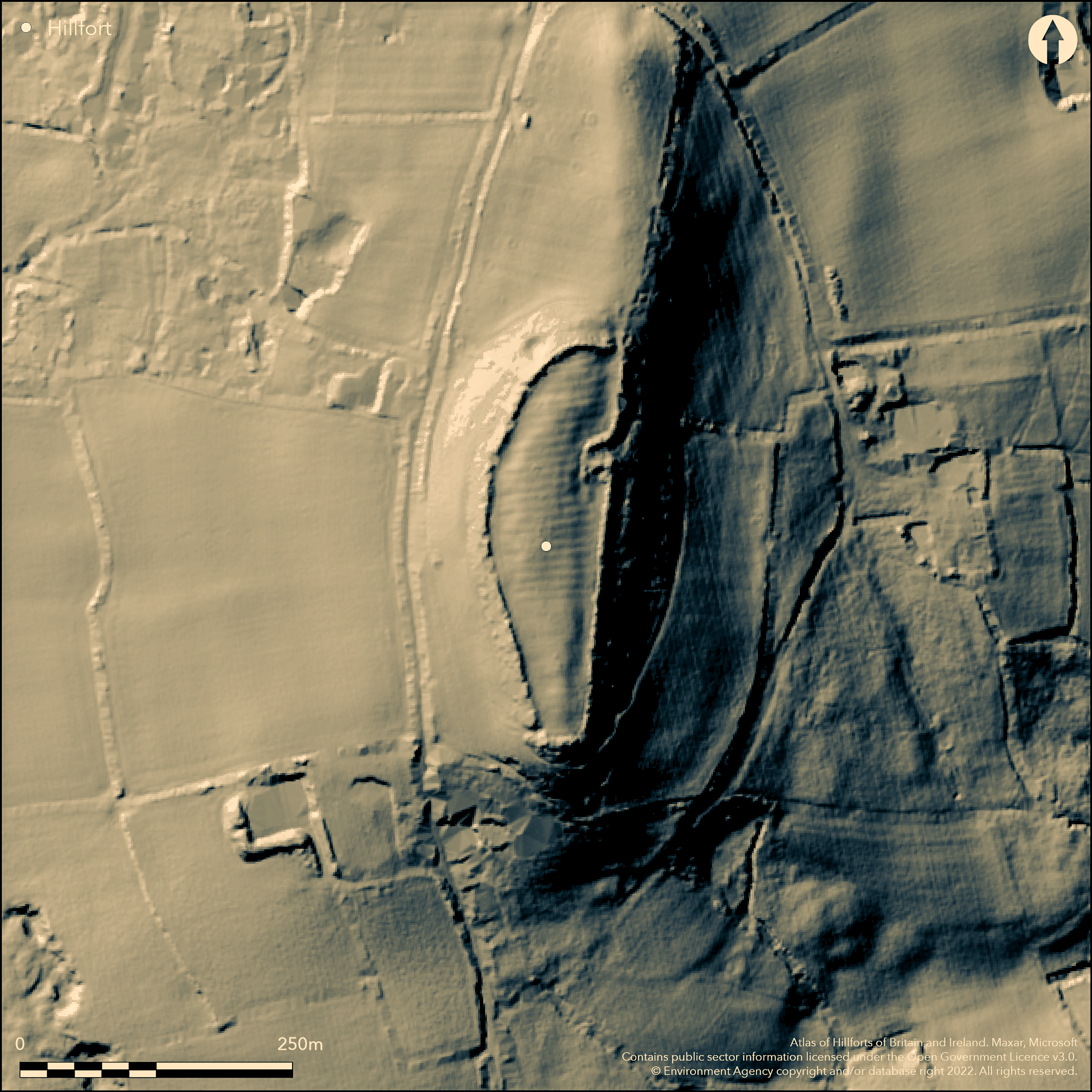
LiDAR 1m DTM Hillshade
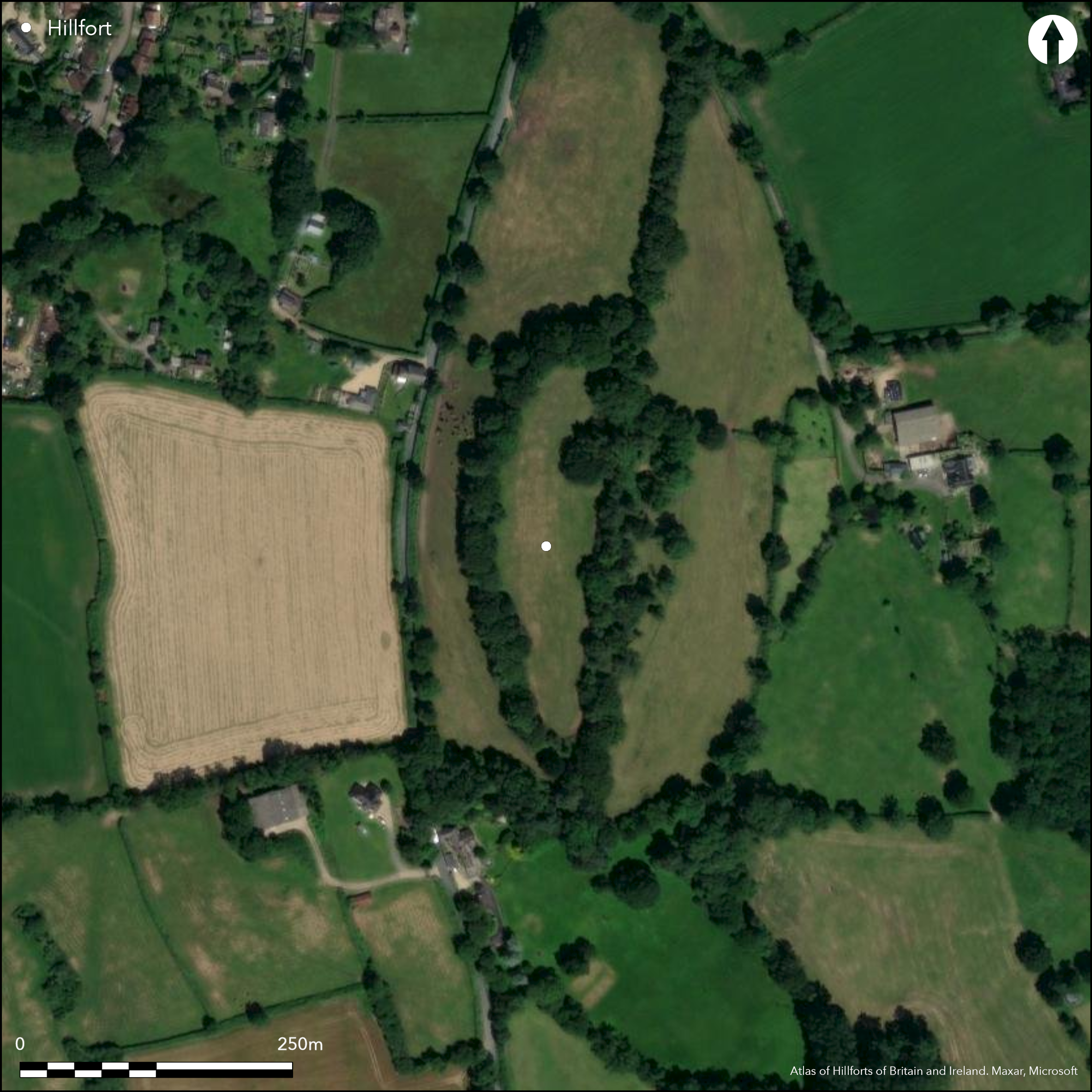
Satellite Imagery
LiDAR 1m DTM Hillshade
Satellite Imagery
Scroll left/right to view further images.
HER: Devon MDV1930 (None)
NMR: ST 20 SE 11 (190202)
SM: 1017951
NGR: ST2827 0284
X: 328272 Y: 102860 (OSGB36)
Univallate contour hillfort located in commanding position at S end of narrow steep sided ridge-backed hill situated between the River Yarty and the River Axe. Steep slopes NE to SE, moderate to strong S, W and less to N. Elongated in plan, measuring c. 225m N-S by 60m, enclosing c. 1.3ha. Defined by earth/stone rampart with chert facing around circuit. To W 5.8m wide with angled outer slope littered with the chert blocks; internally bank near vertical 2m high. On E bank lower and incorporated in later hedge bank, and steep natural defences here suggest scarping of natural hillside rather substantial rampart. Ditch no longer visible. Quarry hollows along inside of W bank and elsewhere. Had effect of creating raised and domed area towards centre of the hillfort, best on N part of interior. Three entrances, one modern on N. Possible original entrance at SW corner where S rampart terminal projects forward and outwards giving gap 3m wide gap. Another on NE side more problematical as much altered and rampart part levelled, with small enclosures placed just within the rampart of probable modern origin. Improved pasture interior, line of trees surround site. Fair condition. Minimal investigations, undated.
Citizen Science: ✗
Reliability of Data: Confirmed
Reliability of Interpretation: Confirmed
X: -336149 Y: 6589649 (EPSG: 3857)
Longitude: -3.019681332573193 Latitude: 50.820760183266074 (EPSG:4326)
Country: England
Current County or Unitary Authority: Devon
Historic County: Devon
Current Parish/Community/Council/Townland: Membury
Fair condition but ditch not visible. On Heritage at Risk Register (2015).
| Extant | ✓ |
| Cropmark | ✗ |
| Likely Destroyed | ✗ |
Improved pasture interior, line of trees surround site.
| Woodland | ✓ |
| Commercial Forestry Plantation | ✗ |
| Parkland | ✗ |
| Pasture (Grazing) | ✓ |
| Arable | ✗ |
| Scrub/Bracken | ✗ |
| Bare Outcrop | ✗ |
| Heather/Moorland | ✗ |
| Heath | ✗ |
| Built-up | ✗ |
| Coastal Grassland | ✗ |
| Other | ✗ |
Univallate contour hillfort located in commanding position at S end of narrow steep sided ridge-backed hill situated between the River Yarty and the River Axe. Steep slopes NE to SE, moderate to strong S, W and less to N.
| Contour Fort | ✓ |
| Partial Contour Fort | ✗ |
| Promontory Fort | ✗ |
| Hillslope Fort | ✗ |
| Level Terrain Fort | ✗ |
| Marsh Fort | ✗ |
| Multiple Enclosure Fort | ✗ |
| Hilltop | ✓ |
| Coastal Promontory | ✗ |
| Inland Promontory | ✗ |
| Valley Bottom | ✗ |
| Knoll/Hillock/Outcrop | ✗ |
| Ridge | ✗ |
| Cliff/Plateau-edge/Scarp | ✗ |
| Hillslope | ✗ |
| Lowland | ✗ |
| Spur | ✗ |
Dominant Topographic Feature: Hill top
| North | ✗ |
| Northeast | ✗ |
| East | ✗ |
| Southeast | ✗ |
| South | ✗ |
| Southwest | ✗ |
| West | ✗ |
| Northwest | ✗ |
| Level | ✓ |
Altitude: 204.0m
N/A
None
Reliability: D - None
| Pre 1200BC | ✗ |
| 1200BC - 800BC | ✗ |
| 800BC - 400BC | ✗ |
| 400BC - AD50 | ✗ |
| AD50 - AD400 | ✗ |
| AD400 - AD 800 | ✗ |
| Post AD800 | ✗ |
| Unknown | ✓ |
| Pre Hillfort: | None |
| Post Hillfort: | None |
Mentioned by J. Davidson, 1833. 1993-96 RCHME aerial photograph primary recording project.
| 1st Identified Written Reference (1833): | J. Davidson mention. |
| Other (None): | RCHME aerial photograph primary recording project. |
Quarry hollows along inside of W bank and elsewhere. Had effect of creating raised and domed area towards centre of the hillfort, best on N part of interior.
None
| None | ✓ |
| Spring | ✗ |
| Stream | ✗ |
| Pool | ✗ |
| Flush | ✗ |
| Well | ✗ |
| Other | ✗ |
Quarry hollows along inside of W bank and elsewhere. Had effect of creating raised and domed area towards centre of the hillfort, best on N part of interior.
| No Known Features | ✗ |
| Round Stone Structures | ✗ |
| Rectangular Stone Structures | ✗ |
| Curvilinear Platforms | ✗ |
| Other Roundhouse Evidence | ✗ |
| Pits | ✗ |
| Quarry Hollows | ✓ |
| Other | ✗ |
None
| No Known Excavation | ✓ |
| Pits | ✗ |
| Postholes | ✗ |
| Roundhouses | ✗ |
| Rectangular Structures | ✗ |
| Roads/Tracks | ✗ |
| Quarry Hollows | ✗ |
| Other | ✗ |
| Nothing Found | ✗ |
None
| No Known Geophysics | ✓ |
| Pits | ✗ |
| Roundhouses | ✗ |
| Rectangular Structures | ✗ |
| Roads/Tracks | ✗ |
| Quarry Hollows | ✗ |
| Other | ✗ |
| Nothing Found | ✗ |
None
| No Known Finds | ✓ |
| Pottery | ✗ |
| Metal | ✗ |
| Metalworking | ✗ |
| Human Bones | ✗ |
| Animal Bones | ✗ |
| Lithics | ✗ |
| Environmental | ✗ |
| Other | ✗ |
None
| APs Not Checked | ✓ |
| None | ✗ |
| Roundhouses | ✗ |
| Rectangular Structures | ✗ |
| Pits | ✗ |
| Postholes | ✗ |
| Roads/Tracks | ✗ |
| Other | ✗ |
Three entrances, one modern on N. Possible original entrance at SW corner where S rampart terminal projects forward and outwards giving gap 3m wide gap. Another on NE side more problematical as much altered and rampart part levelled, with small enclosures placed just within the rampart of probable modern origin.
| 3: | One definite modern entrance on N. |
| 2: | Probable original entrance on SW |
Guard Chambers: ✗
Chevaux de Frise: ✗
| 1. Out-turned (South west): | None |
| 2. Simple Gap (North east): | Damaged. |
Defined by earth/stone rampart with chert facing around circuit. To W 5.8m wide with angled outer slope littered with the chert blocks; internally bank near vertical 2m high. On E bank lower and incorporated in later hedge bank, and steep natural defences here suggest scarping of natural hillside rather substantial rampart. Ditch no longer visible.
| Area 1: | 1.3ha. |
| Total: | 1.3ha. |
Total Footprint Area: Noneha.
None
| ✗ | None |
| ✓ | None |
| NE Quadrant: | 1 |
| SE Quadrant: | 1 |
| SW Quadrant: | 1 |
| NW Quadrant: | 1 |
| Total: | 1 |
| Partial Univallate | ✗ |
| Univallate | ✓ |
| Partial Bivallate | ✗ |
| Bivallate | ✗ |
| Partial Multivallate | ✗ |
| Multivallate | ✗ |
| Unknown | ✗ |
| Partial Univallate | ✗ |
| Univallate | ✗ |
| Partial Bivallate | ✗ |
| Bivallate | ✗ |
| Partial Multivallate | ✗ |
| Multivallate | ✗ |
Earth/stone rampart with chert facing around circuit. To W 5.8m wide with angled outer slope littered with the chert blocks.
| None | ✗ |
| Earthen Bank | ✓ |
| Stone Wall | ✓ |
| Rubble | ✓ |
| Wall-walk | ✗ |
| Evidence of Timber | ✗ |
| Vitrification | ✗ |
| Other Burning | ✗ |
| Palisade | ✗ |
| Counter Scarp Bank | ✗ |
| Berm | ✗ |
| Unfinished | ✗ |
| Other | ✗ |
None
| None | ✗ |
| Earthen Bank | ✗ |
| Stone Wall | ✗ |
| Murus Duplex | ✗ |
| Timber-framed | ✗ |
| Timber-laced | ✗ |
| Vitrification | ✗ |
| Other Burning | ✗ |
| Palisade | ✗ |
| Counter Scarp Bank | ✗ |
| Berm | ✗ |
| Unfinished | ✗ |
| No Known Excavation | ✓ |
| Other | ✗ |
| ✗ | None |
| ✓ | Ditch no longer visible. Probably buried feature. |
Number of Ditches: 1
| ✗ | None |
Allcroft, A.H. 1908. Earthworks of England, London: Macmillan, 201.
Davidson, J. 1833. British and Roman remains near Axminster.
Fox, A. 1996. Prehistoric hillforts in Devon, Tiverton: Devon Books.
Wall, J.C. 1906. Ancient Earthworks, In W. Page (ed), The Victoria County History of the County of Devon, Vol I, London: James Street, Haymarket, 583.
Atlas of Hillforts:
Wikidata:
This work is licensed under CC BY-SA 4.0

 and should be cited as:
Lock, Gary and Ralston, Ian. 2024. Atlas of Hillforts of Britain and Ireland. Available at: https://hillforts.arch.ox.ac.uk
Document Version 1.1