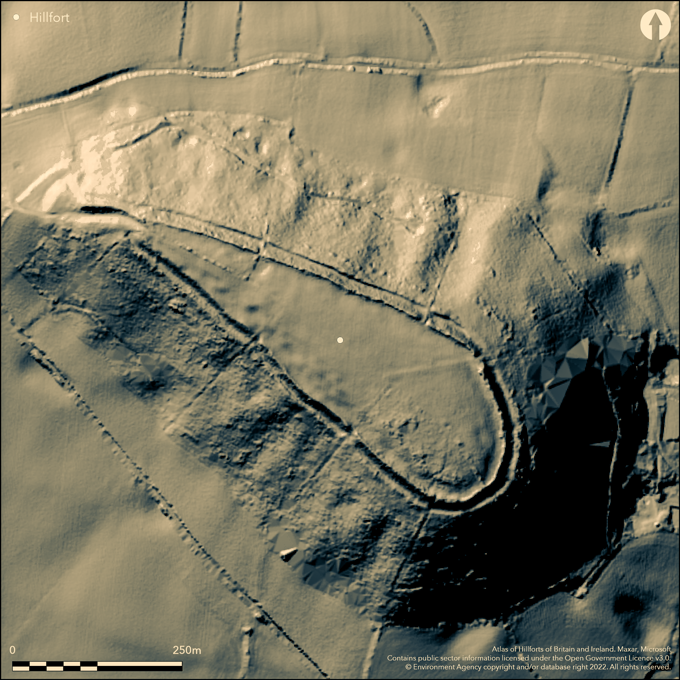
LiDAR 1m DTM Hillshade
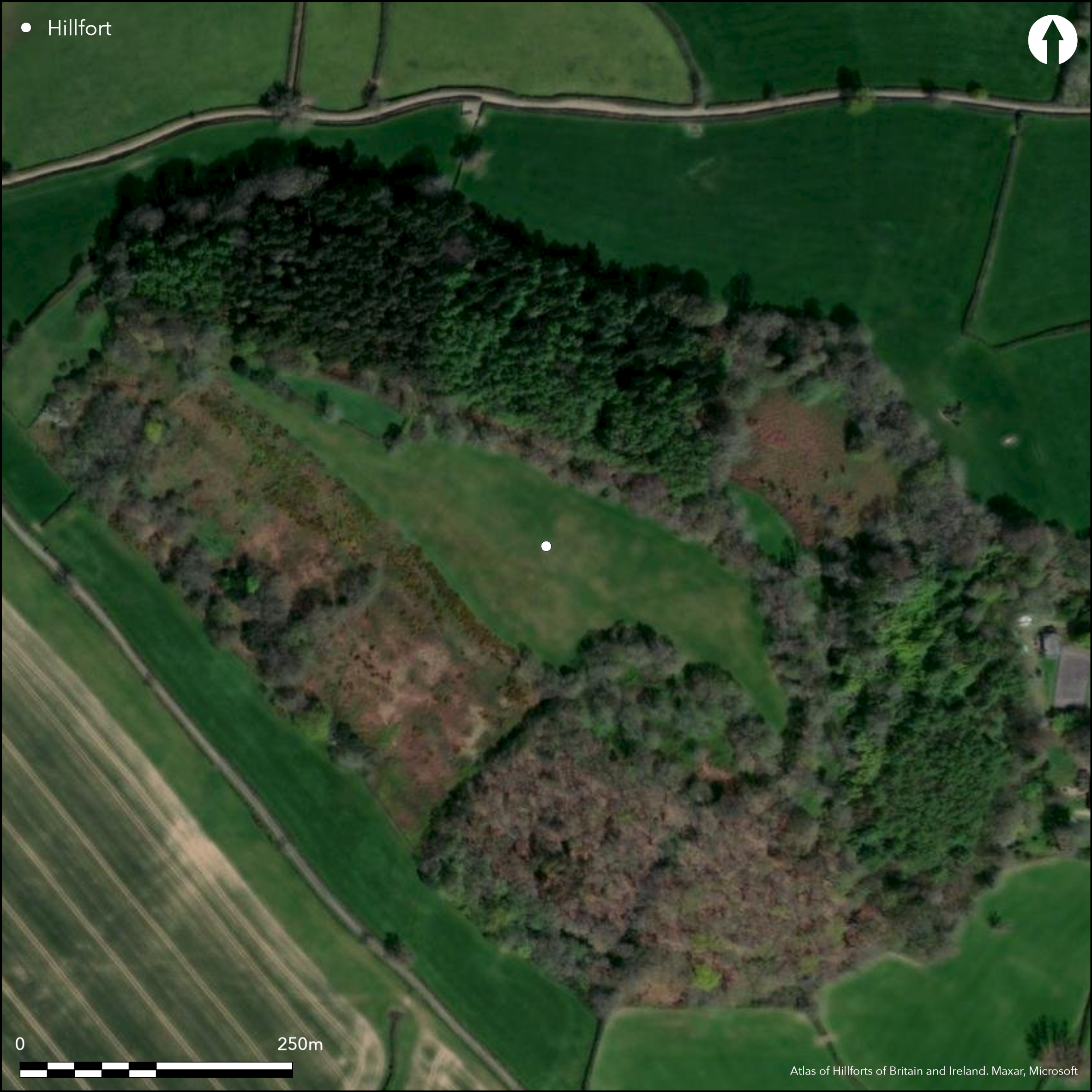
Satellite Imagery
LiDAR 1m DTM Hillshade
Satellite Imagery
Scroll left/right to view further images.
HER: Devon MDV10733 (None)
NMR: SY 19 SW 17 (449434)
SM: 1018849
NGR: SY12849134
X: 312867 Y: 91329 (OSGB36)
Large univallate contour hillfort located in high, elevated, and commanding position on steep-sided hill at end of Greensand spur just W of River Sid. Steep to very steep surrounding slopes. Measures c. 500m long with maximum width 100m, aligned SE-NW. Long, narrow pear-shaped with wider part at SE and encloses c. 4ha. Single earth rampart and ditch with counterscarp enclosing flat interior with quarry hollow. Rampart to 1.2m high, nearly vertical on inside, using steep break of slope on all quadrants varying between 4.4m and 9.6m externally. Outer ditch 2.9m wide and 1m deep. Counterscarp to 1m high merging with natural slope. Single elongated passageway entrance to NW formed by twin extension of ramparts at NW end producing bottleneck passageway c.100m long which has sunken appearance. Scarped platform overlooking hillslope to W would appear to have provided additional cover for W approaches to passageway. At least one hoard of sling stones found in 19th century. Banking forming enclosure in interior at SE corner and two ponds modern. Pasture interior, wooded surrounds. Well-preserved. On 1st Ed. OS map (1889). Undated.
Citizen Science: ✗
Reliability of Data: Confirmed
Reliability of Interpretation: Confirmed
X: -360185 Y: 6571030 (EPSG: 3857)
Longitude: -3.235595961078219 Latitude: 50.71497271608002 (EPSG:4326)
Country: England
Current County or Unitary Authority: Devon
Historic County: Devon
Current Parish/Community/Council/Townland: Sidmouth
Well-preserved.
| Extant | ✓ |
| Cropmark | ✗ |
| Likely Destroyed | ✗ |
Pasture interior, wooded surrounds.
| Woodland | ✓ |
| Commercial Forestry Plantation | ✗ |
| Parkland | ✗ |
| Pasture (Grazing) | ✓ |
| Arable | ✗ |
| Scrub/Bracken | ✗ |
| Bare Outcrop | ✗ |
| Heather/Moorland | ✗ |
| Heath | ✗ |
| Built-up | ✗ |
| Coastal Grassland | ✗ |
| Other | ✗ |
Large univallate contour hillfort located in high, elevated, and commanding position on steep-sided hill at end of Greensand spur just W of River Sid. Steep to very steep surrounding slopes. Aligned SE-NW.
| Contour Fort | ✓ |
| Partial Contour Fort | ✗ |
| Promontory Fort | ✗ |
| Hillslope Fort | ✗ |
| Level Terrain Fort | ✗ |
| Marsh Fort | ✗ |
| Multiple Enclosure Fort | ✗ |
| Hilltop | ✓ |
| Coastal Promontory | ✗ |
| Inland Promontory | ✗ |
| Valley Bottom | ✗ |
| Knoll/Hillock/Outcrop | ✗ |
| Ridge | ✗ |
| Cliff/Plateau-edge/Scarp | ✗ |
| Hillslope | ✗ |
| Lowland | ✗ |
| Spur | ✗ |
Dominant Topographic Feature: Hill top
| North | ✗ |
| Northeast | ✗ |
| East | ✗ |
| Southeast | ✗ |
| South | ✗ |
| Southwest | ✗ |
| West | ✗ |
| Northwest | ✗ |
| Level | ✓ |
Altitude: 186.0m
N/A
Reliability: D - None
| Pre 1200BC | ✗ |
| 1200BC - 800BC | ✗ |
| 800BC - 400BC | ✗ |
| 400BC - AD50 | ✗ |
| AD50 - AD400 | ✗ |
| AD400 - AD 800 | ✗ |
| Post AD800 | ✗ |
| Unknown | ✓ |
| Pre Hillfort: | None |
| Post Hillfort: | None |
On 1st Ed. OS map (1889). Small trench by P.O. Hutchinson 1852 - inconclusive. RCHME aerial photograph primary recording project 1992-96.
| Excavation (1852): | P.O. Hutchinson. |
| 1st Identified Map Depiction (1889): | OS map. |
| Other (1972): | Visited by Hillfort Study Group |
| Other (None): | RCHME aerial photograph primary recording project. |
At least one hoard of sling stones found in 19th century. Quarry hollows.
None
| None | ✓ |
| Spring | ✗ |
| Stream | ✗ |
| Pool | ✗ |
| Flush | ✗ |
| Well | ✗ |
| Other | ✗ |
Quarry hollows.
| No Known Features | ✗ |
| Round Stone Structures | ✗ |
| Rectangular Stone Structures | ✗ |
| Curvilinear Platforms | ✗ |
| Other Roundhouse Evidence | ✗ |
| Pits | ✗ |
| Quarry Hollows | ✓ |
| Other | ✗ |
None
| No Known Excavation | ✗ |
| Pits | ✗ |
| Postholes | ✗ |
| Roundhouses | ✗ |
| Rectangular Structures | ✗ |
| Roads/Tracks | ✗ |
| Quarry Hollows | ✗ |
| Other | ✗ |
| Nothing Found | ✓ |
None
| No Known Geophysics | ✓ |
| Pits | ✗ |
| Roundhouses | ✗ |
| Rectangular Structures | ✗ |
| Roads/Tracks | ✗ |
| Quarry Hollows | ✗ |
| Other | ✗ |
| Nothing Found | ✗ |
At least one hoard of sling stones found in 19th century.
| No Known Finds | ✗ |
| Pottery | ✗ |
| Metal | ✗ |
| Metalworking | ✗ |
| Human Bones | ✗ |
| Animal Bones | ✗ |
| Lithics | ✗ |
| Environmental | ✗ |
| Other | ✓ |
None
| APs Not Checked | ✓ |
| None | ✗ |
| Roundhouses | ✗ |
| Rectangular Structures | ✗ |
| Pits | ✗ |
| Postholes | ✗ |
| Roads/Tracks | ✗ |
| Other | ✗ |
Single elongated passageway entrance to NW formed by twin extension of ramparts at NW end producing bottleneck passageway c.100m long which has sunken appearance. Scarped platform overlooking hillslope to W would appear to have provided additional cover for W approaches to passageway.
| 1: | None |
| 2: | None |
Guard Chambers: ✗
Chevaux de Frise: ✗
| 1. Passage-way/Corridor (North west): | Sunken appearance. |
| 1. Outworks (North west): | Scarped platform overlooking hillslope to W would appear to have provided additional cover for W approaches to passageway. |
Single earth rampart and ditch with counterscarp enclosing flat interior with quarry hollow. Rampart to 1.2m high, nearly vertical on inside, using steep break of slope on all quadrants nd varying between 4.4m and 9.6m externally. Outer ditch 2.9m wide and 1m deep. Counterscarp to 1m high merging with natural slope.
| Area 1: | 4.0ha. |
| Total: | 4.0ha. |
Total Footprint Area: Noneha.
None
| ✗ | None |
| ✓ | None |
| NE Quadrant: | 1 |
| SE Quadrant: | 1 |
| SW Quadrant: | 1 |
| NW Quadrant: | 1 |
| Total: | 1 |
| Partial Univallate | ✗ |
| Univallate | ✓ |
| Partial Bivallate | ✗ |
| Bivallate | ✗ |
| Partial Multivallate | ✗ |
| Multivallate | ✗ |
| Unknown | ✗ |
| Partial Univallate | ✗ |
| Univallate | ✗ |
| Partial Bivallate | ✗ |
| Bivallate | ✗ |
| Partial Multivallate | ✗ |
| Multivallate | ✗ |
Earthen bank. Counterscarp to 1m high merging with natural slope.
| None | ✗ |
| Earthen Bank | ✓ |
| Stone Wall | ✗ |
| Rubble | ✗ |
| Wall-walk | ✗ |
| Evidence of Timber | ✗ |
| Vitrification | ✗ |
| Other Burning | ✗ |
| Palisade | ✗ |
| Counter Scarp Bank | ✓ |
| Berm | ✗ |
| Unfinished | ✗ |
| Other | ✗ |
None
| None | ✓ |
| Earthen Bank | ✗ |
| Stone Wall | ✗ |
| Murus Duplex | ✗ |
| Timber-framed | ✗ |
| Timber-laced | ✗ |
| Vitrification | ✗ |
| Other Burning | ✗ |
| Palisade | ✗ |
| Counter Scarp Bank | ✗ |
| Berm | ✗ |
| Unfinished | ✗ |
| No Known Excavation | ✗ |
| Other | ✗ |
| ✗ | None |
| ✓ | Outer ditch 2.9m wide and 1m deep. |
Number of Ditches: 1
| ✗ | None |
Bradley, R. 1971. Stock raising and the origins of the hillfort on the South Downs, Antiq J. 51, 20-21.
Fox, A. 1996. Prehistoric hillforts in Devon, Tiverton: Devon Books.
Hutchinson, P. O. 1868. Hill Fortresses, slingstones and other antiquities in SE Devon, Trans. Devonshire Assoc, 2, 376.
Griffith, F.M. and Wilkes, E.M. 2011. In the footsteps of pioneering women: some recent work on Devon hillforts, In Pearce, S (ed). Recent archaeological work in South-Western Britain, BAR British Series 548.
Orlando, P. Hutchinson's Travels in Victorian Devon: Illustrated Journals and Sketchbooks, ed J. Butler.
Wall, J.C. 1906. Ancient Earthworks, In W. Page (ed), The Victoria County History of the County of Devon, Vol I, London: James Street, Haymarket, 587.
Atlas of Hillforts:
Wikidata:
This work is licensed under CC BY-SA 4.0

 and should be cited as:
Lock, Gary and Ralston, Ian. 2024. Atlas of Hillforts of Britain and Ireland. Available at: https://hillforts.arch.ox.ac.uk
Document Version 1.1