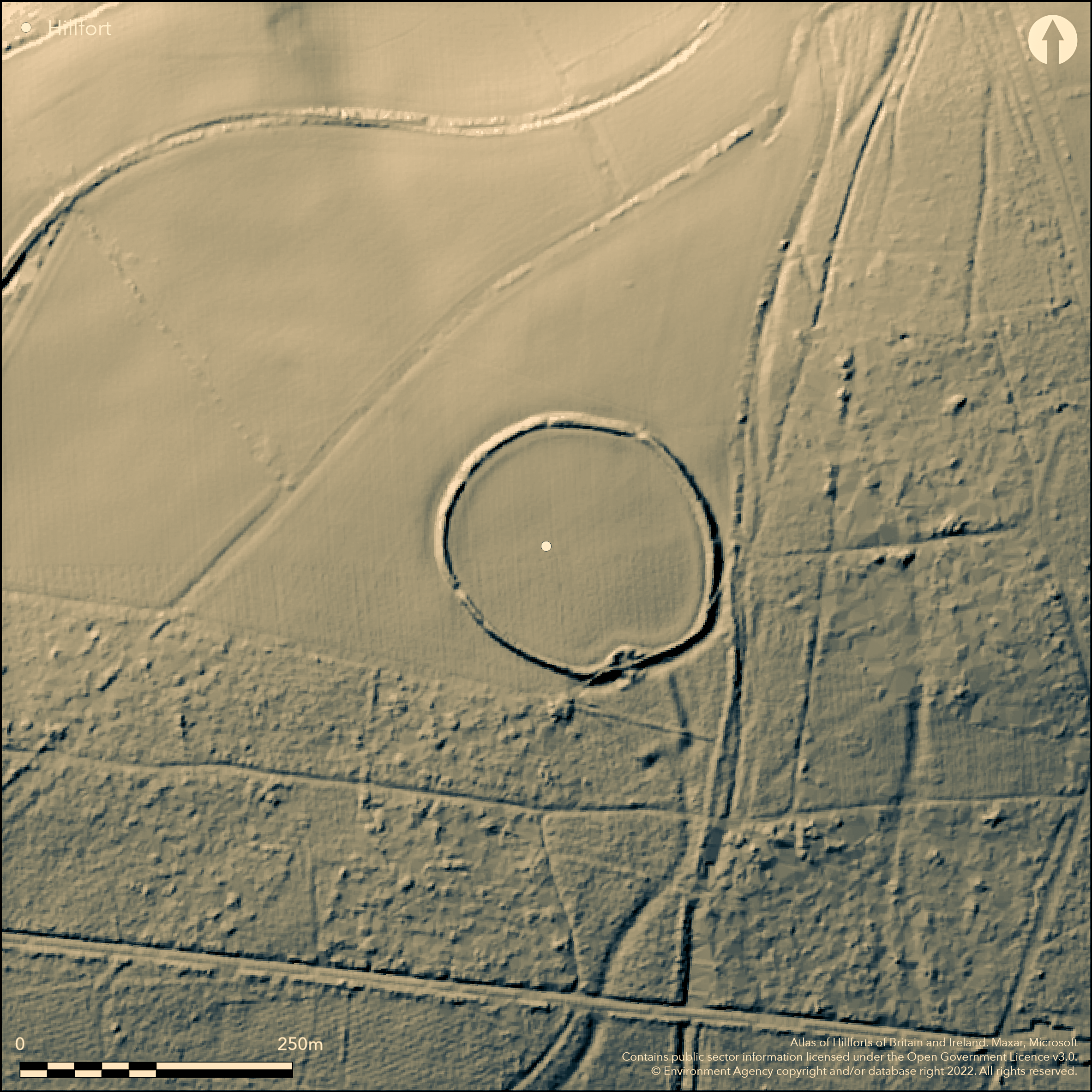
LiDAR 1m DTM Hillshade
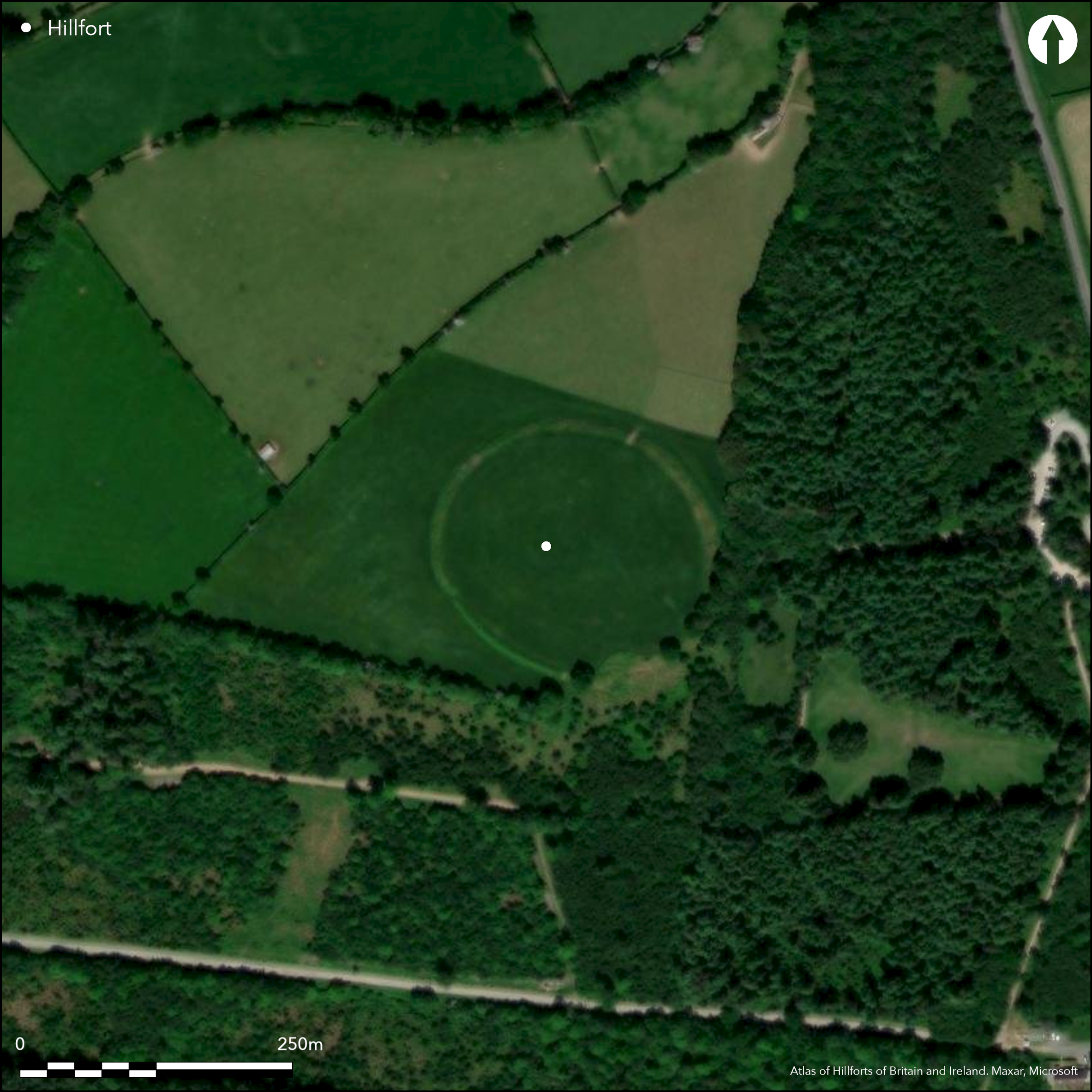
Satellite Imagery
LiDAR 1m DTM Hillshade
Satellite Imagery
Scroll left/right to view further images.
HER: Devon MDV1751 (None)
NMR: SX 55 NW 2 (438415)
SM: 1019946
NGR: SX54415961
X: 254396 Y: 59639 (OSGB36)
Univallate partial contour hillfort located on flat hill top above River Plym, which flows into Plymouth Sound, to W and tributary stream to N. Far-reaching views to N, Moderate, then steep, slopes to N, E, S and W, moderate along ridge to NE. Nearly round c. 145m across, with internal area c. 1.7ha. Associated complex outworks and ring ditch. Defined by single rampart, 8m wide and c. 0.8m-1.6m high internally and between 2.3m-3.5m to an outer ditch, best on SE where 1.5m deep. Slight counterscarp to N and W to 0.3m high. Level interior where geophysics found internal ditch within upstanding bank, postholes of possible four-post structures and curvilinear ditch, providing partition. Original inturned entrance to SE, with 3m wide passageway, later mutilated and blocked. Modern quarry damaged causeway across ditch. Barbican (trapezoidal outwork) protects entrance, with interior 37.5m N-S, tapering E-W from 42m wide to 23m at S end. Its bank rises to 0.4m internally, with ditch 6m wide and 0.4m deep. Outer entrance to barbican 5m wide with hollow way. Barbican can be equated with that at Blackbury Camp (Atlas No. 3350). Outwork on E side of the fort and curves around to NW, connected this to main rampart on N. Ditch of crescent-shaped outwork on NW side 35m from rampart c. 70m long and 8m wide. Ring ditch 20m to its S is 35m diameter with ditch 2m wide, probably late Neolithic or Bronze Age burial mound. Earthwork bank to NW of fort is on WNW-ESE 95m long and 12m wide. It survives up to 0.3m high. Hollow way to E of fort To the east of the fort medieval road from Plympton to Shaugh Prior abandoned by 1840. Improved pasture. Well-preserved despite stated damage. On 1st Ed. OS map (1886). Undated.
Citizen Science: ✗
Reliability of Data: Confirmed
Reliability of Interpretation: Confirmed
X: -450951 Y: 6519062 (EPSG: 3857)
Longitude: -4.05095735065336 Latitude: 50.41845082519736 (EPSG:4326)
Country: England; None
Current County or Unitary Authority: Devon
Historic County: Devon
Current Parish/Community/Council/Townland: Sparkwell; Shaugh Prior
Well-preserved despite some damage to ramparts ditch almost obliterated by ploughing.
| Extant | ✓ |
| Cropmark | ✗ |
| Likely Destroyed | ✗ |
Improved pasture. Some scrub on banks. Wooded/scrub surrounds to E, S and SW.
| Woodland | ✗ |
| Commercial Forestry Plantation | ✗ |
| Parkland | ✗ |
| Pasture (Grazing) | ✓ |
| Arable | ✗ |
| Scrub/Bracken | ✓ |
| Bare Outcrop | ✗ |
| Heather/Moorland | ✗ |
| Heath | ✗ |
| Built-up | ✗ |
| Coastal Grassland | ✗ |
| Other | ✗ |
Univallate partial contour hillfort located on flat hill top above River Plym, which flows into Plymouth Sound, to W and tributary stream to N. Far-reaching views to N, Moderate, then steep, slopes to N, E, S and W, moderate along ridge to NE.
| Contour Fort | ✗ |
| Partial Contour Fort | ✓ |
| Promontory Fort | ✗ |
| Hillslope Fort | ✗ |
| Level Terrain Fort | ✗ |
| Marsh Fort | ✗ |
| Multiple Enclosure Fort | ✗ |
| Hilltop | ✓ |
| Coastal Promontory | ✗ |
| Inland Promontory | ✗ |
| Valley Bottom | ✗ |
| Knoll/Hillock/Outcrop | ✗ |
| Ridge | ✗ |
| Cliff/Plateau-edge/Scarp | ✗ |
| Hillslope | ✗ |
| Lowland | ✗ |
| Spur | ✗ |
Dominant Topographic Feature: Hill top
| North | ✗ |
| Northeast | ✗ |
| East | ✗ |
| Southeast | ✗ |
| South | ✗ |
| Southwest | ✗ |
| West | ✗ |
| Northwest | ✗ |
| Level | ✓ |
Altitude: 139.0m
Boundary Type: Parish/Townland
None
Reliability: D - None
| Pre 1200BC | ✗ |
| 1200BC - 800BC | ✗ |
| 800BC - 400BC | ✗ |
| 400BC - AD50 | ✗ |
| AD50 - AD400 | ✗ |
| AD400 - AD 800 | ✗ |
| Post AD800 | ✗ |
| Unknown | ✓ |
| Pre Hillfort: | None |
| Post Hillfort: | None |
On 1st Ed. OS map (1886). Geophysical survey Ancient Monuments Laboratory 1979. Survey by W. Slater and T. Pearson c. 1985. Evaluation excavtion Exeter Museums Service 1995 (limited investigation preparatory to hedgerow removal). RCHME survey 1991, 2000, ref. no. 621454. Fieldwork MPP 2000. Geophysical survey E. M. Wilkes 2006.
| 1st Identified Map Depiction (1886): | OS map. |
| Geophysical Survey (1979): | Ancient Monuments Laboratory. |
| Excavation (1995): | Evaluation - Exeter Museums Service. |
| Other (2000): | Fieldwork MPP. |
| Geophysical Survey (2006): | E.M. Wilkes, Bournemouth University. |
| Earthwork Survey (None): | Fieldwork RCHME. |
| Other (None): | Survey by W. Slater and T. Pearson. |
Geophysics found internal ditch within upstanding bank, postholes of possible four-post structures and curvilinear ditch providing partition.
None
| None | ✓ |
| Spring | ✗ |
| Stream | ✗ |
| Pool | ✗ |
| Flush | ✗ |
| Well | ✗ |
| Other | ✗ |
None
| No Known Features | ✗ |
| Round Stone Structures | ✗ |
| Rectangular Stone Structures | ✗ |
| Curvilinear Platforms | ✗ |
| Other Roundhouse Evidence | ✗ |
| Pits | ✗ |
| Quarry Hollows | ✓ |
| Other | ✗ |
None
| No Known Excavation | ✓ |
| Pits | ✗ |
| Postholes | ✗ |
| Roundhouses | ✗ |
| Rectangular Structures | ✗ |
| Roads/Tracks | ✗ |
| Quarry Hollows | ✗ |
| Other | ✗ |
| Nothing Found | ✗ |
Internal ditch within upstanding bank. Postholes of possible four-post structures. Curvilinear ditch.
| No Known Geophysics | ✗ |
| Pits | ✗ |
| Roundhouses | ✗ |
| Rectangular Structures | ✓ |
| Roads/Tracks | ✗ |
| Quarry Hollows | ✓ |
| Other | ✓ |
| Nothing Found | ✗ |
None
| No Known Finds | ✓ |
| Pottery | ✗ |
| Metal | ✗ |
| Metalworking | ✗ |
| Human Bones | ✗ |
| Animal Bones | ✗ |
| Lithics | ✗ |
| Environmental | ✗ |
| Other | ✗ |
None
| APs Not Checked | ✓ |
| None | ✗ |
| Roundhouses | ✗ |
| Rectangular Structures | ✗ |
| Pits | ✗ |
| Postholes | ✗ |
| Roads/Tracks | ✗ |
| Other | ✗ |
Original inturned entrance to SE, with 3m wide passageway, later mutilated and blocked. Modern quarry damaged causeway across ditch. Barbican (trapezoidal outwork) protects entrance, with interior 37.5m N-S, tapering E-W from 42m wide to 23m at S end. Its bank rises to 0.4m internally, with ditch 6m wide and 0.4m deep. Outer entrance to barbican 5m wide with hollow way. Barbican can be equated with that at Blackbury Castle (Atlas No. 3350).
| None: | Some modern breaks - not determined. |
| 2: | Complex SE entrance with barbican. |
Guard Chambers: ✗
Chevaux de Frise: ✗
| 1. In-turned (South east): | Original inturned entrance to SE, with 3m wide passageway, later mutilated and blocked. |
| 1. Passage-way/Corridor (South east): | Original inturned entrance to SE, with 3m wide passageway, later mutilated and blocked. |
| 1. Blocked (South east): | Original inturned entrance to SE, with 3m wide passageway, later mutilated and blocked. |
| 1. Barbican (South east): | Barbican (trapezoidal outwork) protects entrance. |
| 2. Hollow Way (South east): | Outer entrance to barbican with hollow way. |
| 2. Hollow Way (South east): | Outer entrance to barbican with hollow way. |
Defined by single rampart, 8m wide and c. 0.8m-1.6m high internally and between 2.3m-3.5m to an outer ditch, best on SE where 1.5m deep. Slight counterscarp to N and W to 0.3m high. Internal ditch within upstanding bank.
| Area 1: | 1.7ha. |
| Total: | 1.7ha. |
Total Footprint Area: Noneha.
None
| ✗ | None |
| ✓ | None |
| NE Quadrant: | 1 |
| SE Quadrant: | 1 |
| SW Quadrant: | 1 |
| NW Quadrant: | 1 |
| Total: | 1 |
| Partial Univallate | ✗ |
| Univallate | ✓ |
| Partial Bivallate | ✗ |
| Bivallate | ✗ |
| Partial Multivallate | ✗ |
| Multivallate | ✗ |
| Unknown | ✗ |
| Partial Univallate | ✗ |
| Univallate | ✗ |
| Partial Bivallate | ✗ |
| Bivallate | ✗ |
| Partial Multivallate | ✗ |
| Multivallate | ✗ |
Slight counterscarp to N and W to 0.3m high.
| None | ✗ |
| Earthen Bank | ✓ |
| Stone Wall | ✗ |
| Rubble | ✓ |
| Wall-walk | ✗ |
| Evidence of Timber | ✗ |
| Vitrification | ✗ |
| Other Burning | ✗ |
| Palisade | ✗ |
| Counter Scarp Bank | ✓ |
| Berm | ✗ |
| Unfinished | ✗ |
| Other | ✗ |
None
| None | ✓ |
| Earthen Bank | ✗ |
| Stone Wall | ✗ |
| Murus Duplex | ✗ |
| Timber-framed | ✗ |
| Timber-laced | ✗ |
| Vitrification | ✗ |
| Other Burning | ✗ |
| Palisade | ✗ |
| Counter Scarp Bank | ✗ |
| Berm | ✗ |
| Unfinished | ✗ |
| No Known Excavation | ✗ |
| Other | ✗ |
| ✗ | None |
| ✓ | Ditch almost obliterated by ploughing. |
Number of Ditches: 1
| ✗ | None |
Bartlett, A. 1979. Magnetometer survey of Boringdon Camp, AML Rep. No 2964, Ancient Monuments Laboratory, English Heritage.
Gent. T.H. 1995. Evaluation excavations in advance of hedgebank removal at Boringdon Camp, Sparkwell. Exeter Archaeology Assessment and Evaluation report.
Griffith, F.M. and Wilkes, E.M. 2011. In the footsteps of pioneering women: some recent work on Devon hillforts, In Pearce, S (ed). Recent archaeological work in South-Western Britain, BAR British Series 548.
Slater, W. and Pearson, T. 1985. A survey of Boringdon Camp, Proc. Devon Archaeol. Soc, 43, 112-15.
Wilkes, E.M. 2007. Report on geophysical survey at Boringdon Camp, south Devon, Unpublished client report (SHDC), available at Devon HER.
Atlas of Hillforts:
Wikidata:
This work is licensed under CC BY-SA 4.0

 and should be cited as:
Lock, Gary and Ralston, Ian. 2024. Atlas of Hillforts of Britain and Ireland. Available at: https://hillforts.arch.ox.ac.uk
Document Version 1.1