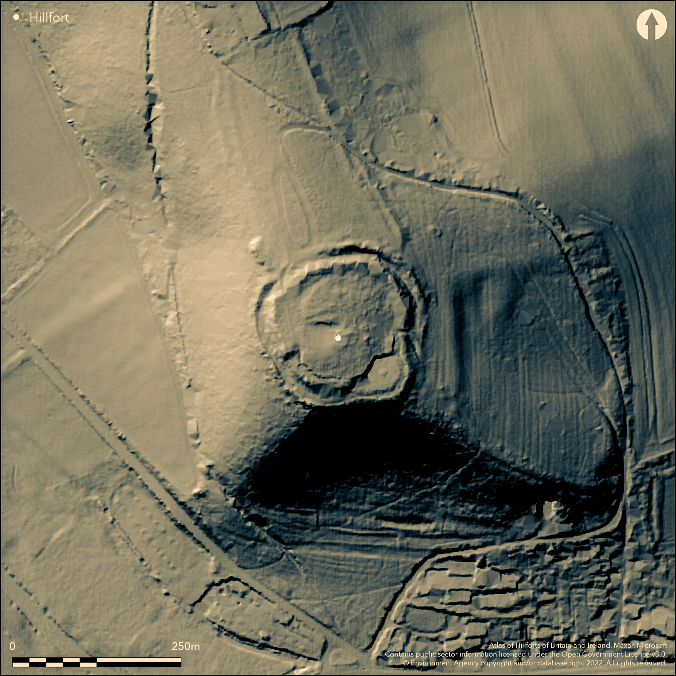
LiDAR 1m DTM Hillshade
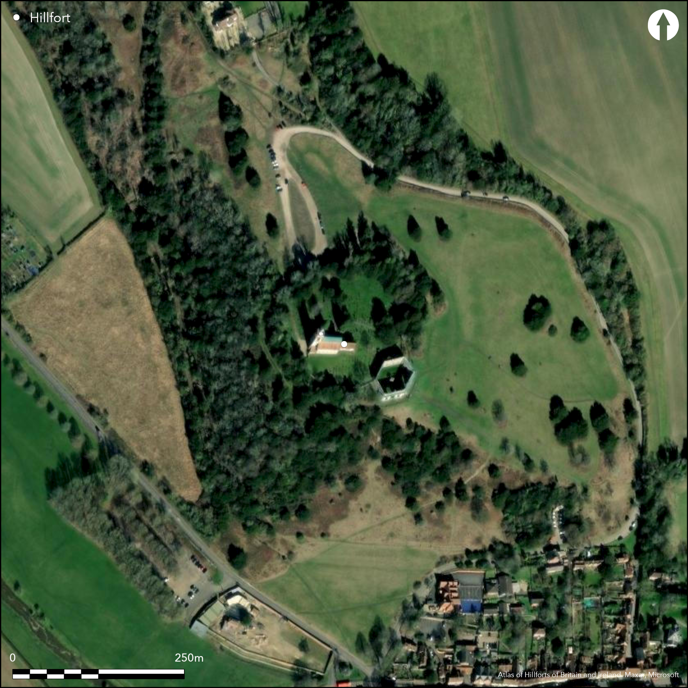
Satellite Imagery
LiDAR 1m DTM Hillshade
Satellite Imagery
Scroll left/right to view further images.
HER: Buckinghamshire 1900000 (None)
NMR: SU 89 NW 1 (248687)
SM: 1003261
NGR: SU 8275 9497
X: 482750 Y: 194970 (OSGB36)
Lying on Church Hill, West Wycombe, at 156m OD, a partially bivallate hillfort of 1.1ha. Its location, on the southern end of an inland promontory where the ground drops away steeply to the W and SW, offers views in all directions, particularly in the S and E and along the River Wye Valley. It has a line of sight with Desborough Castle (Atlas No. 3452), 2.5km SSE. Oval in plan it measures 120m E-W by 100m transversely and comprised two banks with a medial ditch, those in the SE now destroyed by an 18th century mausoleum. The ramparts survive best in the NE where the inner bank stands at 3m and the outer bank at 1.7m above the ditch which is 15m wide and 1.68m deep. In the SW two massive scarps have been terraced into the slope. The inner rampart is composed of earth, flint and chalk rubble. The overall width of the works is between 21-25m. Within and outside the ramparts in the NW, two cuts, one 3.52m wide and over 0.5m deep, the second 7m wide, was observed during a watching brief for a pipeline (Poore 2000). These are considered to be paired ditches for an outwork or more probably further defences on the easiest line of approach (ibid.) the innermost ditch appears to lie on the line of the hillfort ditch. The location of original entrances is unknown, but the discovery of the ditches close to the present NW entrance, would make an original entrance here unlikely. An entrance most likely lay within the now destroyed SE sectors, and a break to the N of the Mausoleum, on a survey plan created for VCH (1908), appears to show rounded terminals. The absence of graves along the N-S path to the W of the Mausoleum suggests it had a long period use. The medieval church of St Lawrence and its graveyard lies within the interior bounded by the inner bank in the N. Iron Age pottery recovered during grave digging was dated to the 2nd century BC. A single sherd of flint and quartz tempered pottery, probably late Bronze Age or Iron Age was recovered during the watching brief. The site is recorded on 1875-76 1:2,500 OS mapping. Scheduled
Citizen Science: ✓
Reliability of Data: Confirmed
Reliability of Interpretation: Confirmed
X: -89656 Y: 6736620 (EPSG: 3857)
Longitude: -0.8053979052643963 Latitude: 51.64739779912997 (EPSG:4326)
Country: England
Current County or Unitary Authority: Buckinghamshire
Historic County: Buckinghamshire
Current Parish/Community/Council/Townland: West Wycombe
The ground has been levelled in the SE at the approach to the church. The hillfort is owned by The National Trust. The slope to the SW of the site of trees is being cleared as part of a landscape management programme
| Extant | ✓ |
| Cropmark | ✗ |
| Likely Destroyed | ✓ |
Church and churchyard, mausoleum
| Woodland | ✗ |
| Commercial Forestry Plantation | ✗ |
| Parkland | ✓ |
| Pasture (Grazing) | ✗ |
| Arable | ✗ |
| Scrub/Bracken | ✗ |
| Bare Outcrop | ✗ |
| Heather/Moorland | ✗ |
| Heath | ✗ |
| Built-up | ✓ |
| Coastal Grassland | ✗ |
| Other | ✓ |
A contour fort occupying a narrow spur of an inland promontory at 156m OD
| Contour Fort | ✓ |
| Partial Contour Fort | ✗ |
| Promontory Fort | ✗ |
| Hillslope Fort | ✗ |
| Level Terrain Fort | ✗ |
| Marsh Fort | ✗ |
| Multiple Enclosure Fort | ✗ |
| Hilltop | ✓ |
| Coastal Promontory | ✗ |
| Inland Promontory | ✓ |
| Valley Bottom | ✗ |
| Knoll/Hillock/Outcrop | ✗ |
| Ridge | ✗ |
| Cliff/Plateau-edge/Scarp | ✗ |
| Hillslope | ✗ |
| Lowland | ✗ |
| Spur | ✓ |
Dominant Topographic Feature: Spur
| North | ✗ |
| Northeast | ✗ |
| East | ✗ |
| Southeast | ✗ |
| South | ✓ |
| Southwest | ✗ |
| West | ✓ |
| Northwest | ✗ |
| Level | ✗ |
Altitude: 156.0m
N/A
The only dating comes from a small number of pottery sherds
Reliability: B - Medium
| Pre 1200BC | ✗ |
| 1200BC - 800BC | ✗ |
| 800BC - 400BC | ✓ |
| 400BC - AD50 | ✓ |
| AD50 - AD400 | ✗ |
| AD400 - AD 800 | ✗ |
| Post AD800 | ✗ |
| Unknown | ✗ |
| Pre Hillfort: | None |
| Post Hillfort: | None |
| Artefactual: | Pottery |
| Morphology/Earthwork/Typology: | None |
Recorded on 1875-76 1:2,500 OS mapping. Plan in VCH (Page 1908, 26). Field investigations, 1970, 1972, 2001 Watching brief by Oxford Archaeology during the digging of a 320m long 0.45m wide pipe trench in September 2000 (Poore 2000). Scheduled
| 1st Identified Written Reference (1908): | None |
| Other (1970): | Field investigation |
| Other (1972): | Field investigation |
| Other (2000): | Watching brief |
| Other (2001): | Field investigation |
| 1st Identified Map Depiction (None): | None |
| Other (None): | Scheduled |
No features contemporary with the use of the hillfort are recorded. The ramparts in the SE are overlain by the Dashwood family Mausoleum. The church of St Lawrence lies W of centre within the enclosure with the northern sector bounded by the inner bank
The river Wye runs approximately 300m W and S, with marshy ground to the SE
| None | ✓ |
| Spring | ✗ |
| Stream | ✗ |
| Pool | ✗ |
| Flush | ✗ |
| Well | ✗ |
| Other | ✗ |
None
| No Known Features | ✓ |
| Round Stone Structures | ✗ |
| Rectangular Stone Structures | ✗ |
| Curvilinear Platforms | ✗ |
| Other Roundhouse Evidence | ✗ |
| Pits | ✗ |
| Quarry Hollows | ✗ |
| Other | ✗ |
None
| No Known Excavation | ✓ |
| Pits | ✗ |
| Postholes | ✗ |
| Roundhouses | ✗ |
| Rectangular Structures | ✗ |
| Roads/Tracks | ✗ |
| Quarry Hollows | ✗ |
| Other | ✗ |
| Nothing Found | ✗ |
None
| No Known Geophysics | ✓ |
| Pits | ✗ |
| Roundhouses | ✗ |
| Rectangular Structures | ✗ |
| Roads/Tracks | ✗ |
| Quarry Hollows | ✗ |
| Other | ✗ |
| Nothing Found | ✗ |
None
| No Known Finds | ✗ |
| Pottery | ✓ |
| Metal | ✗ |
| Metalworking | ✗ |
| Human Bones | ✗ |
| Animal Bones | ✗ |
| Lithics | ✗ |
| Environmental | ✗ |
| Other | ✗ |
None
| APs Not Checked | ✓ |
| None | ✗ |
| Roundhouses | ✗ |
| Rectangular Structures | ✗ |
| Pits | ✗ |
| Postholes | ✗ |
| Roads/Tracks | ✗ |
| Other | ✗ |
The location of original entrances is unknown, but the discovery of the ditches close to the present NW entrance, would make an original entrance here unlikely. An entrance most likely lay within the now destroyed SE defences, and a break to the N of the Mausoleum, on a survey plan created for VCH (1908), appears to show rounded terminals.
| 2: | Both breaks are modern |
| 2: | None |
Guard Chambers: ✗
Chevaux de Frise: ✗
Partially bivallate enclosing 1.1ha. Oval in plan it measures 120m E-W by 100m transversely and comprised two banks with a medial ditch, the arc of the defences in the SE is now destroyed. The defences survive best in the NE where the inner bank stands at 3m, and the outer bank at 1.7m, above the ditch which is 15m wide and 1.68m deep. In the SW two massive scarps have been terraced into the slope. The inner rampart is composed of earth, flint and chalk rubble.
| Area 1: | 1.1ha. |
| Total: | 1.1ha. |
Total Footprint Area: Noneha.
None
| ✗ | None |
| ✗ | Presumed destroyed in the SE, scarps in the SW |
| NE Quadrant: | 2 |
| SE Quadrant: | 2 |
| SW Quadrant: | 2 |
| NW Quadrant: | 2 |
| Total: | 2 |
| Partial Univallate | ✗ |
| Univallate | ✗ |
| Partial Bivallate | ✗ |
| Bivallate | ✓ |
| Partial Multivallate | ✗ |
| Multivallate | ✗ |
| Unknown | ✗ |
| Partial Univallate | ✗ |
| Univallate | ✗ |
| Partial Bivallate | ✗ |
| Bivallate | ✗ |
| Partial Multivallate | ✗ |
| Multivallate | ✗ |
None
| None | ✗ |
| Earthen Bank | ✓ |
| Stone Wall | ✗ |
| Rubble | ✗ |
| Wall-walk | ✗ |
| Evidence of Timber | ✗ |
| Vitrification | ✗ |
| Other Burning | ✗ |
| Palisade | ✗ |
| Counter Scarp Bank | ✗ |
| Berm | ✗ |
| Unfinished | ✗ |
| Other | ✗ |
There has been no excavation across the extant earthworks
| None | ✗ |
| Earthen Bank | ✗ |
| Stone Wall | ✗ |
| Murus Duplex | ✗ |
| Timber-framed | ✗ |
| Timber-laced | ✗ |
| Vitrification | ✗ |
| Other Burning | ✗ |
| Palisade | ✗ |
| Counter Scarp Bank | ✗ |
| Berm | ✗ |
| Unfinished | ✗ |
| No Known Excavation | ✓ |
| Other | ✗ |
| ✗ | None |
| ✓ | Primary hillfort ditch. Further ditch(es) recorded during a watching brief |
Number of Ditches: 2
| ✗ | None |
Farley, M. 1995. The Buckinghamshire Chilterns in Later Prehistory, in Chiltern Archaeology: recent work. A handbook for the next decade. (ed. R. Holgate). The Book Castle, Dunstable
Page, W. (ed) 1908. The Victoria History of the County of Buckingham, Vol. 2, 26
Poore, D. 2000. St. Lawrence's Church, West Wycombe, Buckinghamshire. Archaeological Watching Brief Report. Oxford Archaeological Unit. https://library.thehumanjourney.net/2136/1/WYSLC00-Pdfa.pdf. Accessed October 2015
Atlas of Hillforts:
Wikidata:
This work is licensed under CC BY-SA 4.0

 and should be cited as:
Lock, Gary and Ralston, Ian. 2024. Atlas of Hillforts of Britain and Ireland. Available at: https://hillforts.arch.ox.ac.uk
Document Version 1.1