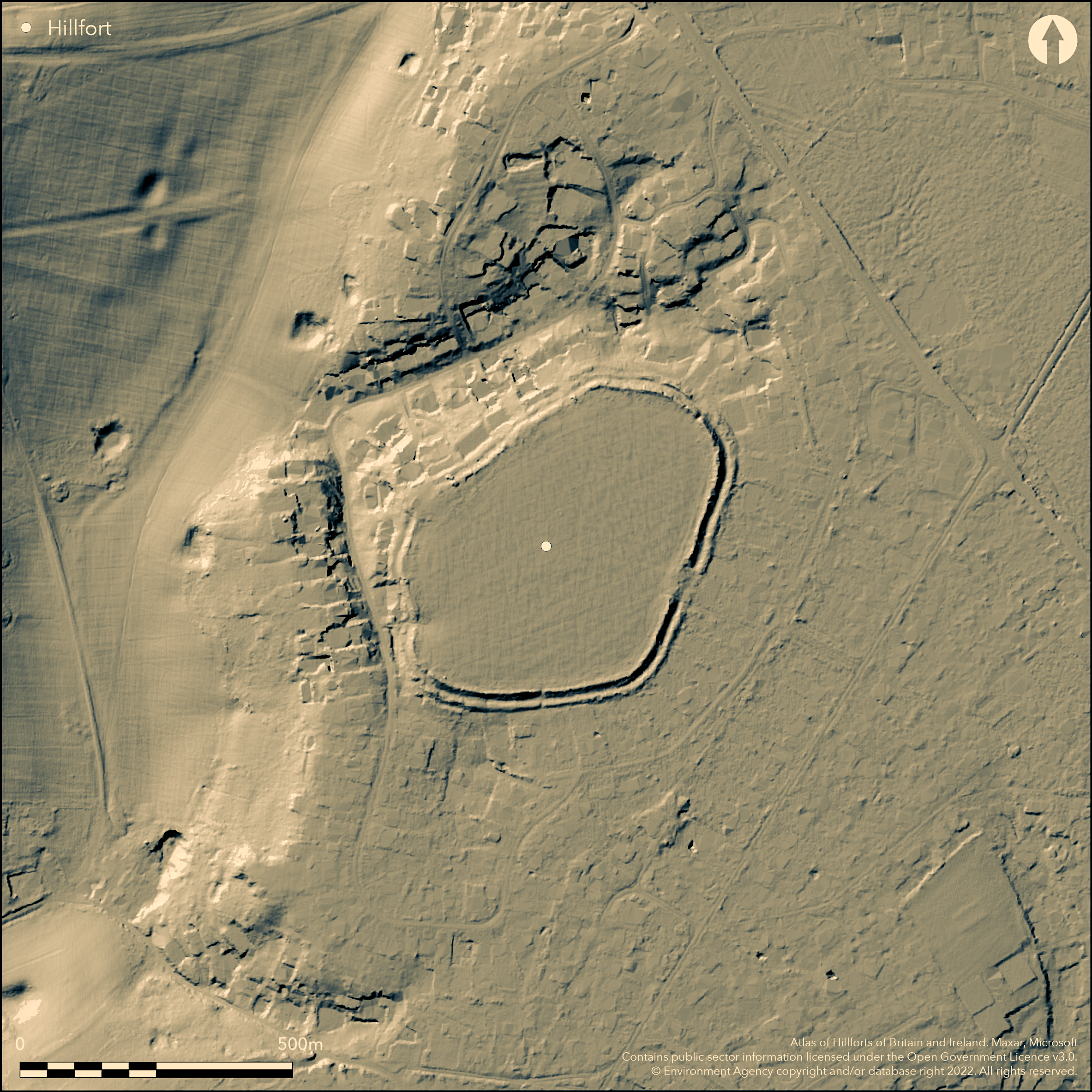
LiDAR 1m DTM Hillshade
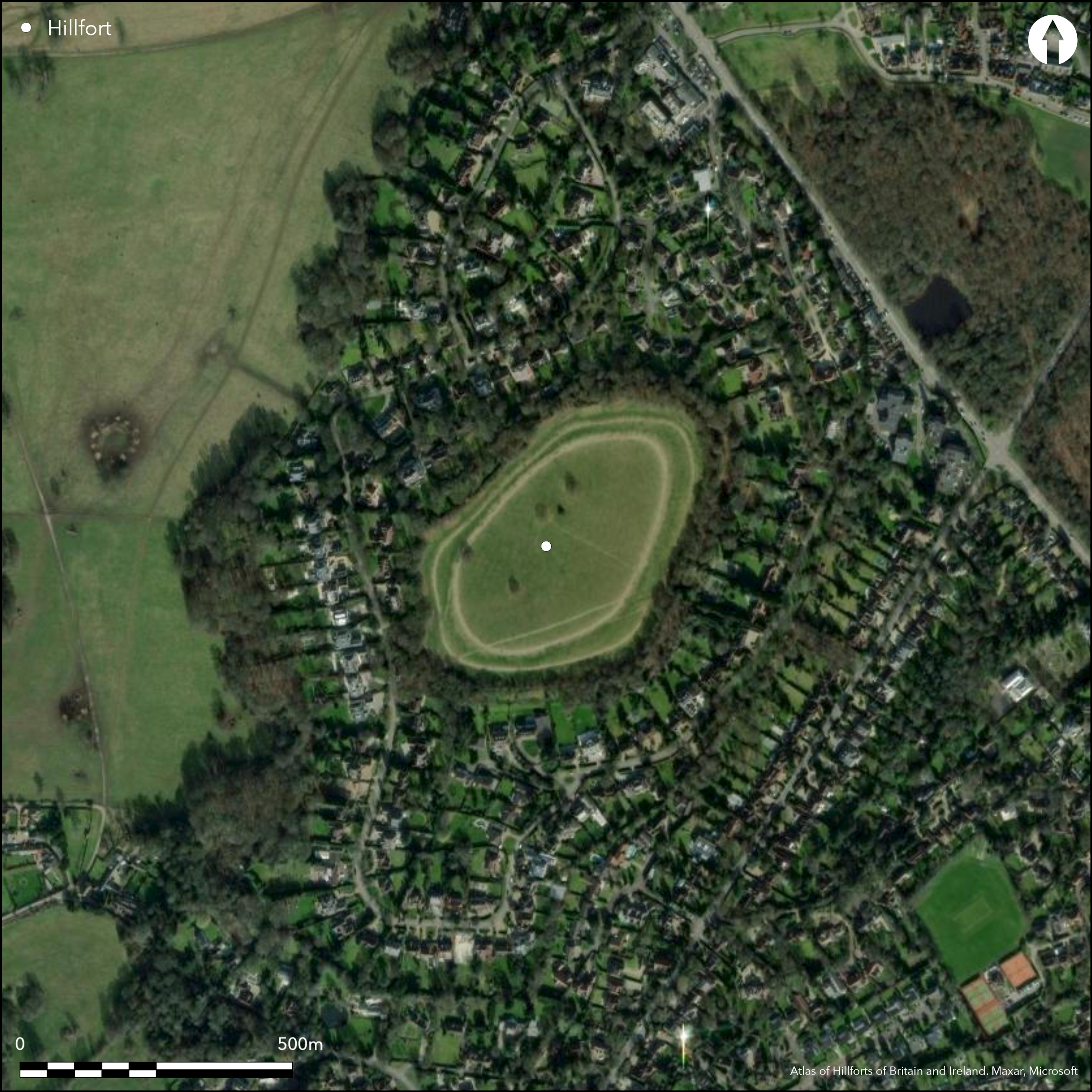
Satellite Imagery
LiDAR 1m DTM Hillshade
Satellite Imagery
Scroll left/right to view further images.
HER: Buckinghamshire 152500000 (None)
NMR: SU 98 NE 2 (251460)
SM: 1006954
NGR: SU 9946 8801
X: 499467 Y: 188019 (OSGB36)
Occupying a level plateau at 85m OD, on the summit of Crab Hill, a bivallate hillfort located within Bulstrode Park between the Misbourne and Alderbourne valleys. At 8.9ha, Bulstrode Camp is the largest hillfort in Buckinghamshire. The ramparts follow the natural contours producing an oval ground plan comprising two banks and a ditch. The inner bank survives to a maximum height of 1.5m above the interior and 3m above the bottom of the inner ditch, the outer bank 1.5m above the bottom of the outer ditch. Excavation has shown the outer bank to be constructed of sandy gravels (Fox and Clarke 1925). Excavation of the ditches was abandoned owing to a high water table and flooding. The western ramparts follow the steep escarpment, with the outer bank and ditch diminishing westwards where the escarpment is steepest. A watching brief for a pipeline in 1969 recorded two post-holes in the interior and evidence of a previously unknown inner ditch. Five breaks were recorded by Fox and Clarke with gaps in the SW and NE lying adjacent to springs, although the breaks are not considered original. Buildings and gaps in the ramparts are shown on an estate map of 1686. This map also shows a tree-lined avenue extending across the interior from a private residence towards a gap in the E (Fox and Clarke 1925, 287), which might be an original entrance. A number of anomalies were recorded during a geophysical survey, mostly around the margins of the interior in the N, speculatively identified as hut circles between 9-16m in diameter, and possibly a Neolithic long barrow (Gover 2003). Small amounts of charcoal and burnt flint recovered from the interior (Fox and Clarke 1925) during excavation, possibly resulting from forest fires. Three sherds of possible early Iron Age pottery, and a circle of pebbles interpreted as a crude hearth, were also found. The use of the hillfort as a public open space and the sale of some parts of it to individuals, with housing encroaching on to the ramparts, has resulted in damage to the earthworks and as a consequence a number of small investigations and archaeological recordings have taken place (for example Anthony 2002; Ford and Taylor 2002; Hammond 2005; Gilbert 2006 and 2009) although nothing further was identified. Described as a 'supposed camp' on 1875-77 OS mapping. Scheduled
Citizen Science: ✓
Reliability of Data: Confirmed
Reliability of Interpretation: Confirmed
X: -62988 Y: 6724934 (EPSG: 3857)
Longitude: -0.5658267348435064 Latitude: 51.58221188227065 (EPSG:4326)
Country: England
Current County or Unitary Authority: Buckinghamshire
Historic County: Buckinghamshire
Current Parish/Community/Council/Townland: Gerrards Cross
Damage recorded during a 2014 citizen science survey through local residents putting in fences and bulb planting into the ramparts. Further damage has occurred through footfall and the establishment of new entry points. Trees and scrub have grown on the ramparts with tree roots are now penetrating the banks and ditches.
| Extant | ✓ |
| Cropmark | ✗ |
| Likely Destroyed | ✗ |
Public open space, grassland, domestic use
| Woodland | ✗ |
| Commercial Forestry Plantation | ✗ |
| Parkland | ✓ |
| Pasture (Grazing) | ✗ |
| Arable | ✗ |
| Scrub/Bracken | ✗ |
| Bare Outcrop | ✗ |
| Heather/Moorland | ✗ |
| Heath | ✗ |
| Built-up | ✓ |
| Coastal Grassland | ✗ |
| Other | ✗ |
Occupying a level plateau at 85m OD on the summit of Crab Hill, a contour fort located within Bulstrode Park, between the Misbourne and Alderbourne valleys.
| Contour Fort | ✓ |
| Partial Contour Fort | ✗ |
| Promontory Fort | ✗ |
| Hillslope Fort | ✗ |
| Level Terrain Fort | ✗ |
| Marsh Fort | ✗ |
| Multiple Enclosure Fort | ✗ |
| Hilltop | ✓ |
| Coastal Promontory | ✗ |
| Inland Promontory | ✗ |
| Valley Bottom | ✗ |
| Knoll/Hillock/Outcrop | ✗ |
| Ridge | ✗ |
| Cliff/Plateau-edge/Scarp | ✗ |
| Hillslope | ✗ |
| Lowland | ✓ |
| Spur | ✗ |
Dominant Topographic Feature: Level plateau
| North | ✗ |
| Northeast | ✗ |
| East | ✗ |
| Southeast | ✗ |
| South | ✗ |
| Southwest | ✗ |
| West | ✗ |
| Northwest | ✗ |
| Level | ✓ |
Altitude: 85.0m
N/A
Three sherds of possible early Iron Age pottery
Reliability: B - Medium
| Pre 1200BC | ✗ |
| 1200BC - 800BC | ✗ |
| 800BC - 400BC | ✓ |
| 400BC - AD50 | ✗ |
| AD50 - AD400 | ✗ |
| AD400 - AD 800 | ✗ |
| Post AD800 | ✗ |
| Unknown | ✗ |
| Pre Hillfort: | None |
| Post Hillfort: | None |
| Artefactual: | None |
| Morphology/Earthwork/Typology: | None |
Recorded on an estate map of 1686 and on 1875-77 OS mapping. Described by Lipscomb (1847). Excavated 1924 (Fox and Clarke 1925, 283-288). Watching brief for a pipeline in 1969 (https://gerrardscross.gov.uk/bulstrode-camp/ accessed October 2015). Geophysical survey 2003. Various interventions owing to the encroachment of housing onto the ramparts. Field investigations 1961, 1974, 1999. Scheduled
| 1st Identified Map Depiction (1695): | None |
| 1st Identified Written Reference (1847): | None |
| Excavation (1924): | None |
| Other (1956): | Scheduled |
| Other (1961): | Field investigation |
| Other (1974): | Field investigation |
| Other (1999): | Field investigation |
| Geophysical Survey (2003): | None |
| Other (None): | Watching brief |
No surface features contemporary with the use of the hillfort are recorded. Possible roundhouses and a potential Neolithic long barrow 60m by 15m recorded in the SW quadrant by geophysics (Gover 2003). Crude hearth and pottery by excavation.
Numerous ponds and diverted water channels fed by springs. The nearest naturally occurring water is the River Misbourne 1.4-1.7 km to the NE and E. Today the Misbourne is an intermittent chalk stream, frequently drying up.
| None | ✓ |
| Spring | ✗ |
| Stream | ✗ |
| Pool | ✗ |
| Flush | ✗ |
| Well | ✗ |
| Other | ✗ |
None
| No Known Features | ✓ |
| Round Stone Structures | ✗ |
| Rectangular Stone Structures | ✗ |
| Curvilinear Platforms | ✗ |
| Other Roundhouse Evidence | ✗ |
| Pits | ✗ |
| Quarry Hollows | ✗ |
| Other | ✗ |
Crude hearth
| No Known Excavation | ✗ |
| Pits | ✗ |
| Postholes | ✗ |
| Roundhouses | ✗ |
| Rectangular Structures | ✗ |
| Roads/Tracks | ✗ |
| Quarry Hollows | ✗ |
| Other | ✓ |
| Nothing Found | ✗ |
Possible roundhouses and a potential Neolithic long barrow 60m by 15m recorded in the SW quadrant (Gover 2003)
| No Known Geophysics | ✗ |
| Pits | ✗ |
| Roundhouses | ✓ |
| Rectangular Structures | ✗ |
| Roads/Tracks | ✗ |
| Quarry Hollows | ✗ |
| Other | ✓ |
| Nothing Found | ✗ |
Small amount of pottery, charcoal and burnt flint
| No Known Finds | ✗ |
| Pottery | ✓ |
| Metal | ✗ |
| Metalworking | ✗ |
| Human Bones | ✗ |
| Animal Bones | ✗ |
| Lithics | ✗ |
| Environmental | ✗ |
| Other | ✓ |
None
| APs Not Checked | ✓ |
| None | ✗ |
| Roundhouses | ✗ |
| Rectangular Structures | ✗ |
| Pits | ✗ |
| Postholes | ✗ |
| Roads/Tracks | ✗ |
| Other | ✗ |
The location of the original entrance is unknown. Five breaks were recorded by Fox and Clarke (1924). Ten breaks were recorded during a citizen science survey, nine of which appeared to be related to later entrances. Several were post-1924 and fairly recent, created as entry points for walkers to the open area, mostly from their properties abutting the site. The only potential entrance is in the E where the footpath from Camp Road enters the site and which is also marked by an old oak, which possibly formed part of the 18th century tree-line crossing the site.
| 10: | None |
| 2: | None |
Guard Chambers: ✗
Chevaux de Frise: ✗
| 1. Simple Gap (East): | Uncertain |
Bivallate contour fort of 8.9ha. The ramparts follow the natural contours producing an oval ground plan comprising two banks and a ditch. The inner bank survives to a maximum height of 1.5m above the interior and 3m above the bottom of the inner ditch, the outer bank 1.5m above the bottom of the outer ditch. Excavation has shown the outer bank to be constructed of sandy gravels (Fox and Clarke 1925). The western defences follow the steep escarpment, with the outer bank and ditch diminishing westwards where the escarpment is steepest. A watching brief for a pipeline in 1969 recorded two postholes in the interior and evidence of a previously unrecorded inner ditch.
| Area 1: | 8.9ha. |
| Total: | 8.9ha. |
Total Footprint Area: Noneha.
None
| ✗ | None |
| ✓ | None |
| NE Quadrant: | 2 |
| SE Quadrant: | 2 |
| SW Quadrant: | 2 |
| NW Quadrant: | 2 |
| Total: | 2 |
| Partial Univallate | ✗ |
| Univallate | ✗ |
| Partial Bivallate | ✗ |
| Bivallate | ✓ |
| Partial Multivallate | ✗ |
| Multivallate | ✗ |
| Unknown | ✗ |
| Partial Univallate | ✗ |
| Univallate | ✗ |
| Partial Bivallate | ✗ |
| Bivallate | ✗ |
| Partial Multivallate | ✗ |
| Multivallate | ✗ |
None
| None | ✗ |
| Earthen Bank | ✓ |
| Stone Wall | ✗ |
| Rubble | ✗ |
| Wall-walk | ✗ |
| Evidence of Timber | ✗ |
| Vitrification | ✗ |
| Other Burning | ✗ |
| Palisade | ✗ |
| Counter Scarp Bank | ✗ |
| Berm | ✗ |
| Unfinished | ✗ |
| Other | ✗ |
Sand and gravels
| None | ✗ |
| Earthen Bank | ✗ |
| Stone Wall | ✗ |
| Murus Duplex | ✗ |
| Timber-framed | ✗ |
| Timber-laced | ✗ |
| Vitrification | ✗ |
| Other Burning | ✗ |
| Palisade | ✗ |
| Counter Scarp Bank | ✗ |
| Berm | ✗ |
| Unfinished | ✗ |
| No Known Excavation | ✗ |
| Other | ✓ |
| ✗ | None |
| ✓ | Possibly a third previously unrecorded inner ditch |
Number of Ditches: 2
| ✗ | None |
Anthony, S. 2002. Polkerris, 65 Camp Road, Gerrards Cross, Buckinghamshire, An Archaeological Watching Brief. Thames Valley Archaeological Services Report CRG 02/89. https://www.tvas.co.uk/reports/pdf/CRG02-89wb.pdf.Accessed October 2015
Burgess, B. 1878. The entrenchment in Bulstrode Park. Rec Buckinghamshire, 5. 326-330
Ford, S. and Taylor, A. 2002. Woodside, 90 Camp Road, Gerrards Cross, Buckinghamshire, An Archaeological
Watching Brief. Thames Valley Archaeological Services Report 01/55. https://www.tvas.co.uk/reports/pdf/WGC01-55wb.pdf. Accessed October 2015
Fox, C. and Clarke, L.C.G. 1925. Excavations in Bulstrode Park. Rec Buckinghamshire, 11, 283-288
Gilbert, D. 2006. An Archaeological Watching Brief at Wykehurst, 96 Camp Road, Gerrards Cross. John Moore Heritage Services. https://archaeologydataservice.ac.uk/archiveDS/archiveDownload?t=arch-988-1/dissemination/pdf/johnmoor1-15328-1.pdf. Accessed October 2015
Gilbert, D. 2009. An Archaeological Watching Brief at 102 Camp Road, Gerrards Cross. John Moore Heritage Services. https://archaeologydataservice.ac.uk/archiveDS/archiveDownload?t=arch-988-1/dissemination/pdf/johnmoor1-64575-1.pdf. Accessed October 2015
Gover, J. 2003. Bulstrode «Iron Age» Camp, Gerrards Cross. A Site of Many Periods. Newsl Chess Valley Archaeol Hist Soc
Hammond, S. 2005. 92 Camp Road, Gerrards Cross: An Archaeological Recording Action. Thames Valley Archaeological Services. Report CRGC05/78. https://www.tvas.co.uk/reports/pdf/CRGC05-78RecA.pdf. Accessed October 2015
Lipscomb G. 1847 History and Antiquities of the County of Buckingham . Vol. VIII
Atlas of Hillforts:
Wikidata:
This work is licensed under CC BY-SA 4.0

 and should be cited as:
Lock, Gary and Ralston, Ian. 2024. Atlas of Hillforts of Britain and Ireland. Available at: https://hillforts.arch.ox.ac.uk
Document Version 1.1