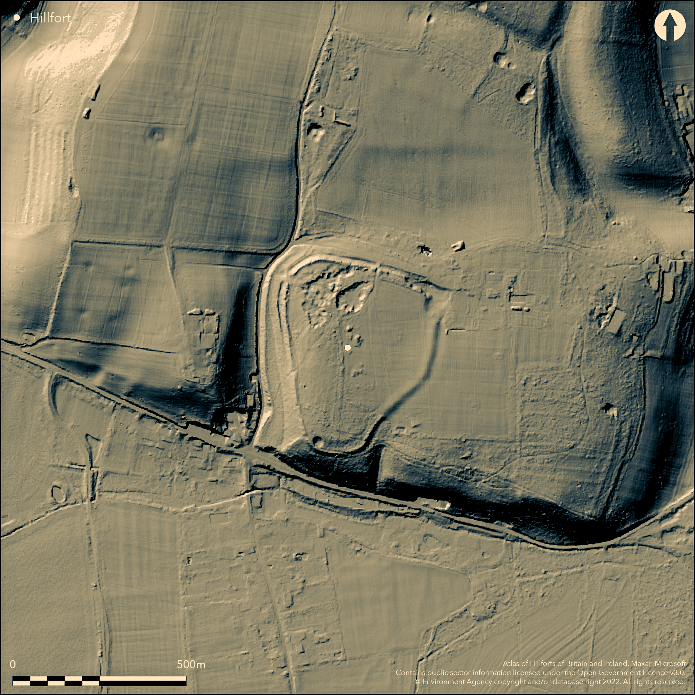
LiDAR 1m DTM Hillshade
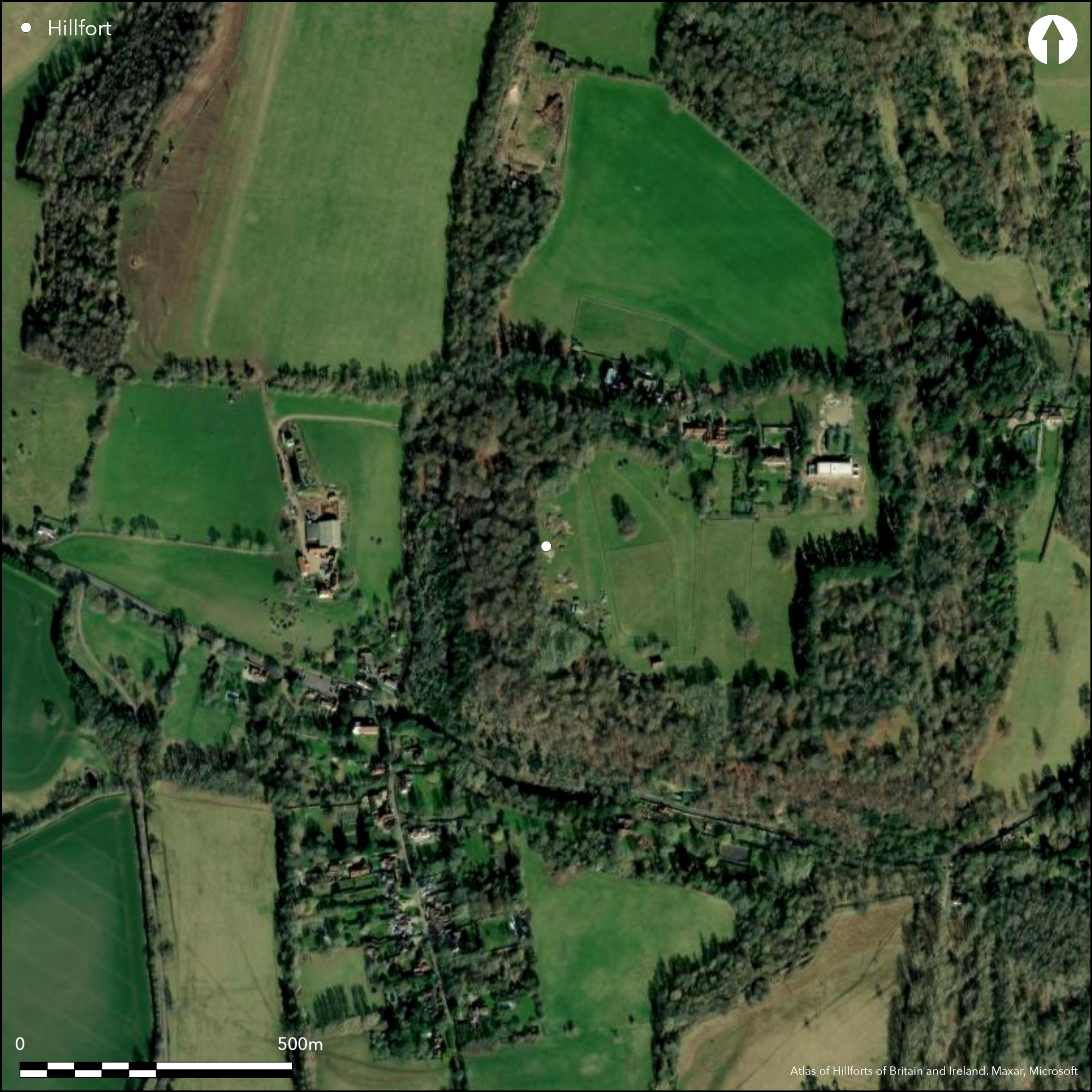
Satellite Imagery
LiDAR 1m DTM Hillshade
Satellite Imagery
Scroll left/right to view further images.
HER: Buckinghamshire 116800000 (None)
NMR: SU 88 SW 16 (248626)
SM: 1013938
NGR: SU 8067 8469
X: 480678 Y: 184691 (OSGB36)
Bounded to the W by Bockmer Lane and to the N by School Lane, Medmenham, a univallate hillfort of 6.6ha. The site occupies the end of a spur at 75m OD with the ground falling away to the S and W, commanding views towards the valley of the River Thames 690m to the S. The hillfort of Danesfield Camp (Atlas No. 3446) lies 800m to the SE. Sub-oval in plan, Medmenham Camp measures 350m N-S by a maximum of 300m E-W, narrowing towards the S where it follows the natural topography. The entire circuit of the hillfort can still be traced, with the ramparts in the S and W preserved within beech woodland. The ground is artificially scarped, ranging in width between 6-12m and up to 3m high, with traces of a bank following the summit. A slight terrace runs around the base. In the N and E, where the ground is relatively level, the bank varies between 5-10m wide and between 0.6-1.7m high. An external ditch averaging 5m wide and 1m deep, continues for some way along the western side. The ramparts survive less well in the E where they have been ploughed in the past, standing 12m wide and 0.6m high, the ditch visible as a shallow depression. A single 12m wide entrance lies at the NW corner with a causeway across the ditch. Slight traces of additional earthworks in this area suggests the entrance may have been more elaborate than it now appears, with a counterscarp bank running for approximately 130m to the S of the entrance, and for a short distance to the N. Traces of a further external ditch runs along the inner edge of a terraced trackway as it approaches the hillfort. The interior is slightly domed, except in the N. No features contemporary with the enclosure are recorded. The NE corner of the hillfort lies within the landscaped gardens of States House. Probable 19th century flint and gravel quarries remain as shallow depressions in the NW. Neolithic and Bronze Age worked flints and a Palaeolithic axe have been found on the ground within and around the hillfort, and the tang and part of the blade of a double-edged knife, possibly Bronze Age, was discovered on the SW rampart. A programme of geophysical, topographic and contour survey and dowsing was carried out by Archaeology in Marlow from 2005 -2008 as part of the ROMADAM (Recording of Marlow and District's Ancient Monuments) Project (Laker 2008). Geophysical survey in the E of the interior failed to identify any internal settlement, although a small number of magnetic anomalies were tentatively interpreted as a possible ring ditch or banjo enclosure. Recorded as Bolebec's Castle on 1876 1:2,500 OS mapping. The location of Bolbec's Castle has since been identified 35km to the N. No excavation has taken place and the site is undated. Scheduled .
Citizen Science: ✓
Reliability of Data: Confirmed
Reliability of Interpretation: Confirmed
X: -93252 Y: 6720113 (EPSG: 3857)
Longitude: -0.8377002700558026 Latitude: 51.55529408927477 (EPSG:4326)
Country: England
Current County or Unitary Authority: Buckinghamshire
Historic County: Buckinghamshire
Current Parish/Community/Council/Townland: Medmenham
None
| Extant | ✓ |
| Cropmark | ✗ |
| Likely Destroyed | ✗ |
Beech woodland in the S and W, open pasture in the E The extreme NE corner of the defences lies within the landscaped garden of States House.
| Woodland | ✓ |
| Commercial Forestry Plantation | ✗ |
| Parkland | ✗ |
| Pasture (Grazing) | ✓ |
| Arable | ✗ |
| Scrub/Bracken | ✗ |
| Bare Outcrop | ✗ |
| Heather/Moorland | ✗ |
| Heath | ✗ |
| Built-up | ✗ |
| Coastal Grassland | ✗ |
| Other | ✓ |
A partial contour fort occuping the end of a spur at 75m OD with the ground falling away to the S and W
| Contour Fort | ✗ |
| Partial Contour Fort | ✓ |
| Promontory Fort | ✗ |
| Hillslope Fort | ✗ |
| Level Terrain Fort | ✗ |
| Marsh Fort | ✗ |
| Multiple Enclosure Fort | ✗ |
| Hilltop | ✓ |
| Coastal Promontory | ✗ |
| Inland Promontory | ✗ |
| Valley Bottom | ✗ |
| Knoll/Hillock/Outcrop | ✗ |
| Ridge | ✗ |
| Cliff/Plateau-edge/Scarp | ✗ |
| Hillslope | ✗ |
| Lowland | ✓ |
| Spur | ✓ |
Dominant Topographic Feature: Spur
| North | ✗ |
| Northeast | ✗ |
| East | ✗ |
| Southeast | ✗ |
| South | ✓ |
| Southwest | ✗ |
| West | ✓ |
| Northwest | ✗ |
| Level | ✗ |
Altitude: 75.0m
N/A
The site is undated. Neolithic and Bronze Age worked flints and a Palaeolithic axe found on the ground within and around the hillfort, and the tang and part of the blade of a double-edged knife, possibly Bronze Age, discovered on the SW rampart. A possible ring ditch or banjo enclosure recorded during geophysical survey.
Reliability: D - None
| Pre 1200BC | ✗ |
| 1200BC - 800BC | ✗ |
| 800BC - 400BC | ✗ |
| 400BC - AD50 | ✗ |
| AD50 - AD400 | ✗ |
| AD400 - AD 800 | ✗ |
| Post AD800 | ✗ |
| Unknown | ✓ |
| Pre Hillfort: | None |
| Post Hillfort: | Ploughed in the E; quarrying; landscaped gardens |
Recorded on 1876 1;2,500 OS mapping. Included in the Inventory of the Historic Monuments of Buckinghamshire (1914). Field investigations in 1970 and 1974. 1993 recorded under the Thames Valley National Mapping Programme. Programme of geophysical, topographic and contour survey and dowsing by Archaeology in Marlow from 2005 -2008 as part of the ROMADAM (Recording of Marlow and District's Ancient Monuments) Project (Laker 2008). Scheduled
| 1st Identified Map Depiction (1876): | None |
| 1st Identified Written Reference (1914): | None |
| Other (1966): | Scheduled |
| Other (1970): | Field investigation |
| Other (1974): | Field investigation |
| Other (1993): | NMP |
| Earthwork Survey (None): | None |
| Geophysical Survey (None): | None |
No surface features contemporary with the use of the hillfort are recorded
River Thames to the S
| None | ✓ |
| Spring | ✗ |
| Stream | ✗ |
| Pool | ✗ |
| Flush | ✗ |
| Well | ✗ |
| Other | ✗ |
None
| No Known Features | ✓ |
| Round Stone Structures | ✗ |
| Rectangular Stone Structures | ✗ |
| Curvilinear Platforms | ✗ |
| Other Roundhouse Evidence | ✗ |
| Pits | ✗ |
| Quarry Hollows | ✗ |
| Other | ✗ |
None
| No Known Excavation | ✓ |
| Pits | ✗ |
| Postholes | ✗ |
| Roundhouses | ✗ |
| Rectangular Structures | ✗ |
| Roads/Tracks | ✗ |
| Quarry Hollows | ✗ |
| Other | ✗ |
| Nothing Found | ✗ |
Possible ring ditch or banjo enclosure
| No Known Geophysics | ✗ |
| Pits | ✗ |
| Roundhouses | ✗ |
| Rectangular Structures | ✗ |
| Roads/Tracks | ✗ |
| Quarry Hollows | ✗ |
| Other | ✓ |
| Nothing Found | ✗ |
None
| No Known Finds | ✗ |
| Pottery | ✗ |
| Metal | ✓ |
| Metalworking | ✗ |
| Human Bones | ✗ |
| Animal Bones | ✗ |
| Lithics | ✓ |
| Environmental | ✗ |
| Other | ✗ |
None
| APs Not Checked | ✓ |
| None | ✗ |
| Roundhouses | ✗ |
| Rectangular Structures | ✗ |
| Pits | ✗ |
| Postholes | ✗ |
| Roads/Tracks | ✗ |
| Other | ✗ |
A single 12m wide entrance lies at the NW corner with a causeway across the ditch. Slight traces of additional earthworks in this area suggests the entrance may have been more elaborate than it now appears.
| 1: | None |
| 2: | None |
Guard Chambers: ✗
Chevaux de Frise: ✗
| 1. Simple Gap (North west): | None |
Sub-oval and univallate, measuring 350m N-S by a maximum of 300m E-W, narrowing towards the S where it follows the natural topography, enclosing 6.6ha. The entire circuit of the hillfort can still be traced, with the defences in the S and W preserved within beech woodland. The ground has an artificial, outward-facing scarp, ranging in width between 6-12m and up to 3m high, with traces of a bank following the summit. A slight terrace runs around the base. In the N and E, where the ground is relatively level, the bank varies between 5-10m wide and between 0.6-1.7m high, with an external ditch averaging 5m wide and 1m deep, which continues for some way along the western side. The defences survive less well in the E where they have been ploughed in the past standing 12m wide and 0.6m high, the ditch visible as a shallow depression. A counterscarp bank runs for approximately 130m to the S of the entrance,
| Area 1: | 6.6ha. |
| Total: | 6.6ha. |
Total Footprint Area: Noneha.
None
| ✗ | None |
| ✓ | Counterscarp in the NW with external ditch |
| NE Quadrant: | 1 |
| SE Quadrant: | 1 |
| SW Quadrant: | 1 |
| NW Quadrant: | 1 |
| Total: | 1 |
| Partial Univallate | ✗ |
| Univallate | ✓ |
| Partial Bivallate | ✗ |
| Bivallate | ✗ |
| Partial Multivallate | ✗ |
| Multivallate | ✗ |
| Unknown | ✗ |
| Partial Univallate | ✗ |
| Univallate | ✗ |
| Partial Bivallate | ✗ |
| Bivallate | ✗ |
| Partial Multivallate | ✗ |
| Multivallate | ✗ |
None
| None | ✗ |
| Earthen Bank | ✓ |
| Stone Wall | ✗ |
| Rubble | ✗ |
| Wall-walk | ✗ |
| Evidence of Timber | ✗ |
| Vitrification | ✗ |
| Other Burning | ✗ |
| Palisade | ✗ |
| Counter Scarp Bank | ✓ |
| Berm | ✗ |
| Unfinished | ✗ |
| Other | ✗ |
None
| None | ✗ |
| Earthen Bank | ✗ |
| Stone Wall | ✗ |
| Murus Duplex | ✗ |
| Timber-framed | ✗ |
| Timber-laced | ✗ |
| Vitrification | ✗ |
| Other Burning | ✗ |
| Palisade | ✗ |
| Counter Scarp Bank | ✗ |
| Berm | ✗ |
| Unfinished | ✗ |
| No Known Excavation | ✓ |
| Other | ✗ |
| ✗ | None |
| ✓ | None |
Number of Ditches: 1
| ✗ | None |
Brown, M. 1993. Thames Valley National Mapping Programme. RCHME
RCHME 1914. An Inventory of the Historic Monuments of Buckinghamshire, 256-7
Laker, J.S. 2008. Romadam Project: Recording of Marlow and District's Ancient Monuments.
Archaeology in Marlow. 2008. The ROMADAM Project: Medmenham Iron Age Hill Fort. Unpublished
Atlas of Hillforts:
Wikidata:
This work is licensed under CC BY-SA 4.0

 and should be cited as:
Lock, Gary and Ralston, Ian. 2024. Atlas of Hillforts of Britain and Ireland. Available at: https://hillforts.arch.ox.ac.uk
Document Version 1.1