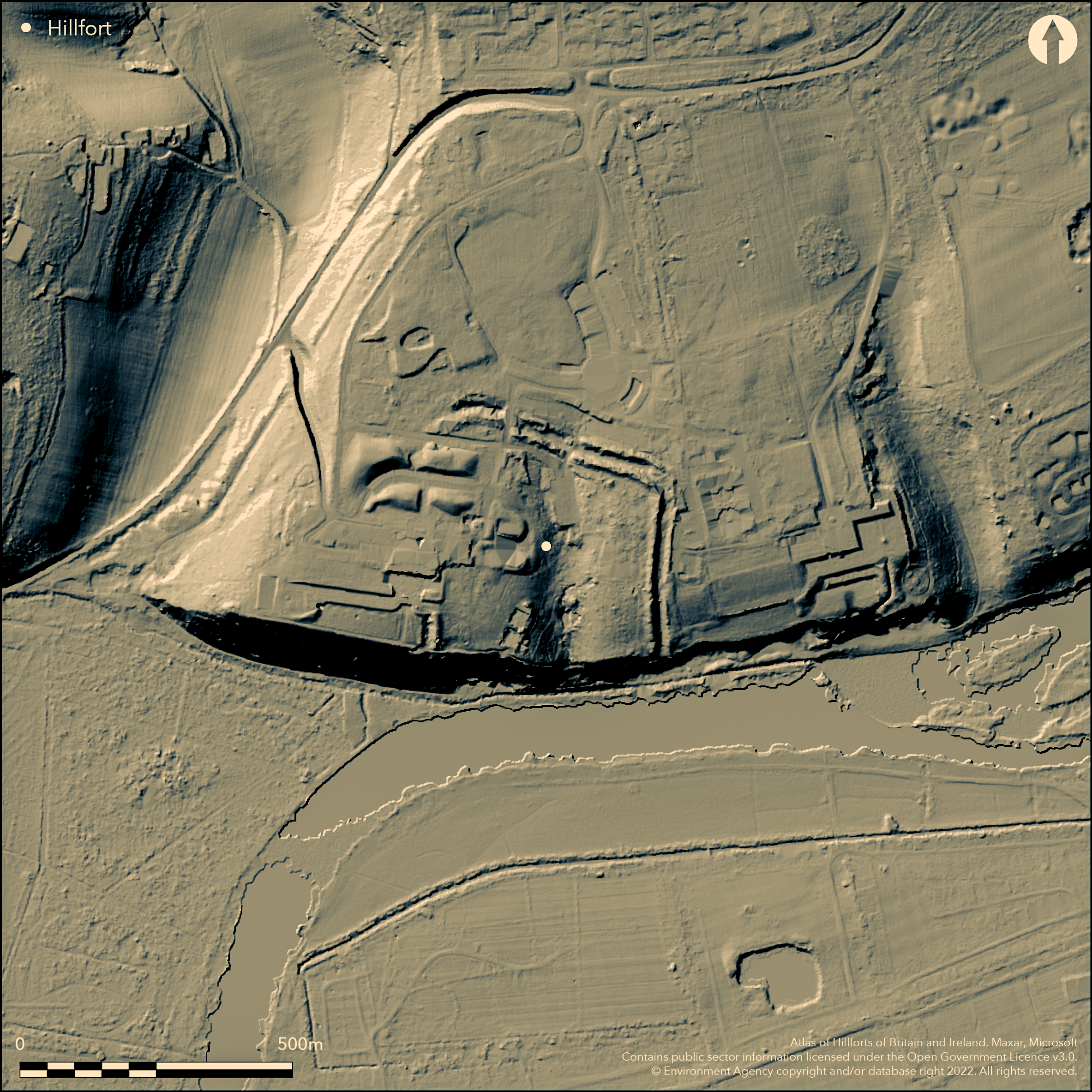
LiDAR 1m DTM Hillshade
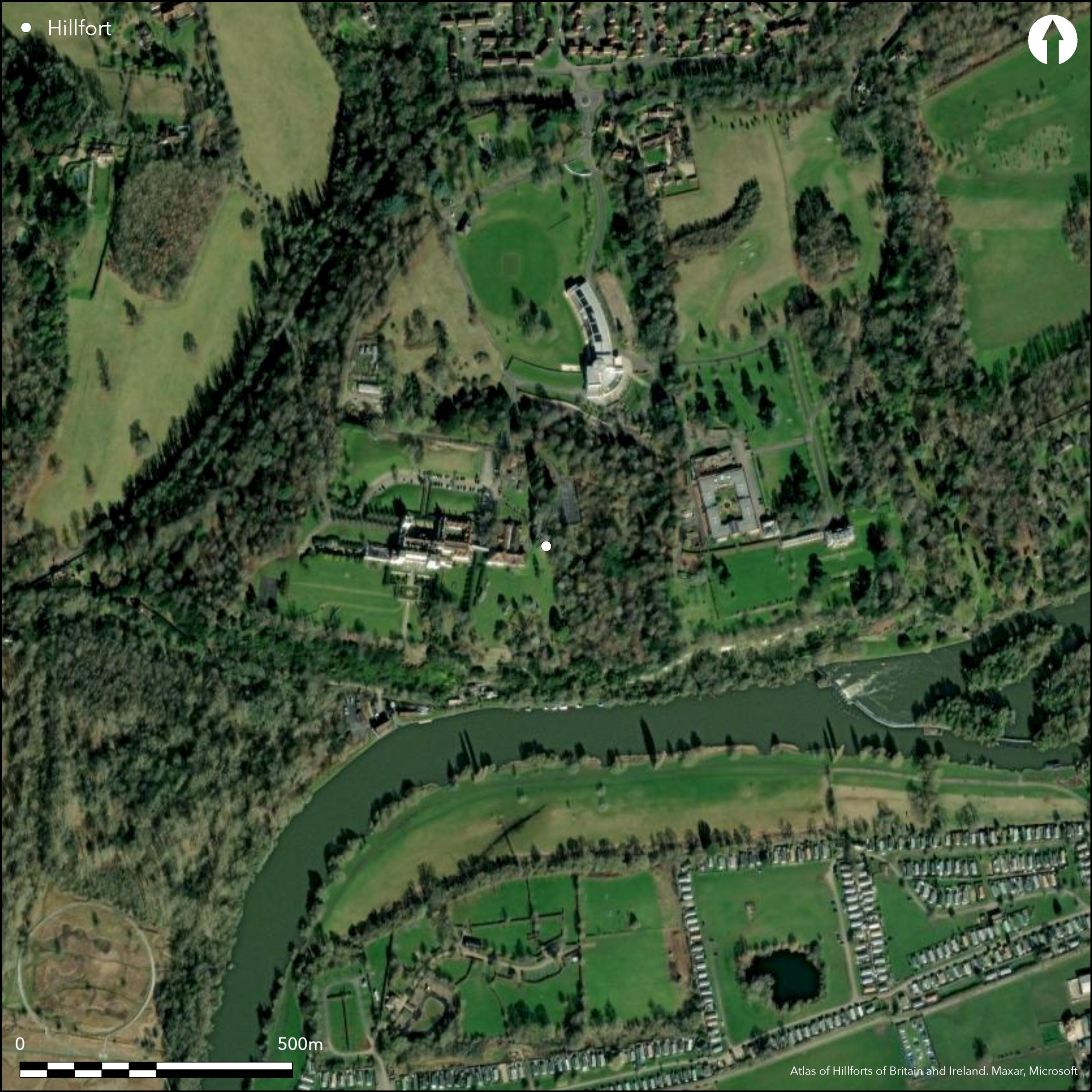
Satellite Imagery
LiDAR 1m DTM Hillshade
Satellite Imagery
Scroll left/right to view further images.
HER: Buckinghamshire 173400000 (None)
NMR: SU 88 SW 15 (248621)
SM: 1014604
NGR: SU 81767 84409
X: 481767 Y: 184409 (OSGB36)
Located approximately 1.2km to the E of Medmenham village and 800m to SE of Medmenham Camp (Atlas No. 3444), a large hillfort of approximately 7.5ha. It occupies a broad chalk outcrop on ground that slopes southwards towards the River Thames providing extensive views across the Thames floodplain into Berkshire. Sub-rectangular in form, it measures approximately 300m E-W by 250m transversely, originally enclosed by ramparts in the N, E and W and naturally defined in the S by a 30m high, steep cliff face above the River Thames. Described by Langley as Çstrong and perfect' in 1797 it is now destroyed or considerably denuded in places. In the E an earthen bank averaging 15m wide and 3m high, and an external ditch approximately 14m wide and 4m deep, extend northwards for 200m from the cliff face. A further bank was recorded beyond the ditch (Cocks 1911), traces of which are still visible. This is possibly a counterscarp. The ramparts survive best in the NE corner where they measure 7m wide and 2m high and continue along the northern side for approximately 170m. The ramparts were almost destroyed in the W by a series of buildings and associated landscaping with only the inner bank and ditch surviving in the SW corner. Former farm buildings, and later a 19th century house, chapel, outbuildings and landscaped gardens lay immediately to the N of the ramparts. A section of the western ramparts is now overlain by the present Danesfield House. Elsewhere on this side they survive only as slight undulations. The original entrance is considered to have lain in the NW. Two modern causeways carry roads across the ramparts to service the buildings. The hillfort was originally considered to be a ÇDanish encampment' (Langley 1797) from which its name derives. Seventy-one Neolithic or Bronze Age flint flakes recovered from a shallow gully, and a further three during the digging of a pipe trench in 1982 (Farley 1983, 169), attest to earlier activity on the site. Small-scale excavations in 1990 revealed a single 11m ditch, probably Neolithic, and a number of pits and postholes containing 66 sherds of middle and late Iron Age pottery, and a post-built circular feature with daub walls (Keevill and Campbell 1991, 87-99). The site is recorded on 1855-1900 OS mapping. Scheduled
Citizen Science: ✓
Reliability of Data: Confirmed
Reliability of Interpretation: Confirmed
X: -91511 Y: 6719631 (EPSG: 3857)
Longitude: -0.8220614229177592 Latitude: 51.55260239098273 (EPSG:4326)
Country: England; None
Current County or Unitary Authority: Buckinghamshire; Windsor and Maidenhead
Historic County: Buckinghamshire
Current Parish/Community/Council/Townland: Medmenham; Hurley
None
| Extant | ✓ |
| Cropmark | ✗ |
| Likely Destroyed | ✓ |
None
| Woodland | ✗ |
| Commercial Forestry Plantation | ✗ |
| Parkland | ✓ |
| Pasture (Grazing) | ✗ |
| Arable | ✗ |
| Scrub/Bracken | ✗ |
| Bare Outcrop | ✗ |
| Heather/Moorland | ✗ |
| Heath | ✗ |
| Built-up | ✓ |
| Coastal Grassland | ✗ |
| Other | ✗ |
A hillslope fort occupying a broad chalk outcrop on ground that slopes southwards between 67-37m OD towards the River Thames, providing extensive views across the Thames floodplain into Berkshire
| Contour Fort | ✗ |
| Partial Contour Fort | ✗ |
| Promontory Fort | ✗ |
| Hillslope Fort | ✓ |
| Level Terrain Fort | ✗ |
| Marsh Fort | ✗ |
| Multiple Enclosure Fort | ✗ |
| Hilltop | ✗ |
| Coastal Promontory | ✗ |
| Inland Promontory | ✗ |
| Valley Bottom | ✗ |
| Knoll/Hillock/Outcrop | ✗ |
| Ridge | ✗ |
| Cliff/Plateau-edge/Scarp | ✗ |
| Hillslope | ✓ |
| Lowland | ✓ |
| Spur | ✗ |
Dominant Topographic Feature: Broad, south-facing chalk outcrop
| North | ✗ |
| Northeast | ✗ |
| East | ✗ |
| Southeast | ✗ |
| South | ✓ |
| Southwest | ✗ |
| West | ✗ |
| Northwest | ✗ |
| Level | ✗ |
Altitude: 60.0m
The River Thames today acts as the boundary between the county of Buckinghamshire and the modern unitary authority of Windsor and Maidenhead and the parishes of Medmenham and Hurley.
Boundary Type: County
Iron Age pottery recovered from pits and postholes. Neolithic ditch discovered during evaluations. Large number of Neolithic or Bronze Age flint flakes recovered. Danesfield House requisitioned as an RAF intelligence base between 1941 and 1977, currently a hotel and spa
Reliability: B - Medium
| Pre 1200BC | ✗ |
| 1200BC - 800BC | ✗ |
| 800BC - 400BC | ✓ |
| 400BC - AD50 | ✓ |
| AD50 - AD400 | ✗ |
| AD400 - AD 800 | ✗ |
| Post AD800 | ✗ |
| Unknown | ✗ |
| Pre Hillfort: | None |
| Post Hillfort: | None |
| Artefactual: | None |
Described in Langley 1797 as a 'Danish Camp'. The site is recorded on 1855-1900 OS mapping. Field investigations in 1970 and 1974. Evaluation trial trenching and subsequent excavation and watching brief by Oxford Archaeological Unit in 1990 (Keevill and Campbell 1991) uncovered evidence for probable Neolithic and Iron Age activity. Watching brief of six trial pits and a single borehole within the NE corner immediately adjacent to the ramparts. No archaeological features contemporary with the hillfort were found (Holmes 1999). Ten machine-excavated test-pits in NE corner of the rampart ditch in 2007 (Keir 2007). Nothing found contemporary with the hillfort. Geophysical survey (Foreman 1998, 25). Topographic and contour survey carried between October 2007 and April 2008 during the ROMADAM (Recording of Marlow and District's Ancient Monuments) Project (Laker 2008). Scheduled.
| 1st Identified Written Reference (1797): | Langley (1797) |
| Other (1970): | Field investigation |
| Other (1974): | Field investigation |
| Other (1979): | Scheduled |
| Excavation (1990): | Keevill and Campbell (1991) |
| Geophysical Survey (1997): | Foreman (1998) |
| Excavation (2007): | Keir (2007) |
| 1st Identified Map Depiction (None): | None |
| Earthwork Survey (None): | (Laker 2008) |
No features contemporary with the hillfort have been recorded. Small-scale excavations in 1990 revealed a single 11m ditch, probably Neolithic, and a number of pits and postholes containing middle and late Iron Age pottery, and a post-built circular feature with daub walls (Keevill and Campbell 1991, 87-99)
The River Thames lies to the S
| None | ✓ |
| Spring | ✗ |
| Stream | ✗ |
| Pool | ✗ |
| Flush | ✗ |
| Well | ✗ |
| Other | ✗ |
None
| No Known Features | ✓ |
| Round Stone Structures | ✗ |
| Rectangular Stone Structures | ✗ |
| Curvilinear Platforms | ✗ |
| Other Roundhouse Evidence | ✗ |
| Pits | ✗ |
| Quarry Hollows | ✗ |
| Other | ✗ |
None
| No Known Excavation | ✗ |
| Pits | ✓ |
| Postholes | ✓ |
| Roundhouses | ✓ |
| Rectangular Structures | ✗ |
| Roads/Tracks | ✗ |
| Quarry Hollows | ✗ |
| Other | ✗ |
| Nothing Found | ✗ |
None
| No Known Geophysics | ✗ |
| Pits | ✗ |
| Roundhouses | ✗ |
| Rectangular Structures | ✗ |
| Roads/Tracks | ✗ |
| Quarry Hollows | ✗ |
| Other | ✗ |
| Nothing Found | ✓ |
None
| No Known Finds | ✗ |
| Pottery | ✓ |
| Metal | ✗ |
| Metalworking | ✗ |
| Human Bones | ✗ |
| Animal Bones | ✗ |
| Lithics | ✓ |
| Environmental | ✗ |
| Other | ✗ |
None
| APs Not Checked | ✓ |
| None | ✗ |
| Roundhouses | ✗ |
| Rectangular Structures | ✗ |
| Pits | ✗ |
| Postholes | ✗ |
| Roads/Tracks | ✗ |
| Other | ✗ |
The original entrance is considered to have lain in the NW, although this is unconfirmed. Two modern causeways carry roads across the ramparts to service the buildings.
| 2: | None |
| 2: | None |
Guard Chambers: ✗
Chevaux de Frise: ✗
Subrectangular in form measuring approximately 300m E-W by 250m transversely. Originally enclosed by ramparts in the N, E and W and naturally defended in the S by a 30m high, steep cliff above the River Thames. Described by Langley as «strong and perfect in 1797 it is now destroyed or considerably denuded in places. In the E an earthen bank averaging 15m wide and 3m high, and an external ditch approximately 14m wide and 4m deep, extend northwards for 200m from the cliff face. A further bank was recorded beyond the ditch (Cocks 1911), traces of which are still visible. This is possibly a counterscarp. The defences survive best in the NE corner where they measure 7m wide and 2m high and continue along the northern side for approximately 170m. The ramparts are almost destroyed in the W.
| Area 1: | 7.5ha. |
| Total: | 7.5ha. |
Total Footprint Area: Noneha.
None
| ✗ | None |
| ✗ | No defences in the S |
| NE Quadrant: | 1 |
| SE Quadrant: | 1 |
| SW Quadrant: | 1 |
| NW Quadrant: | 1 |
| Total: | 1 |
| Partial Univallate | ✗ |
| Univallate | ✓ |
| Partial Bivallate | ✗ |
| Bivallate | ✗ |
| Partial Multivallate | ✗ |
| Multivallate | ✗ |
| Unknown | ✗ |
| Partial Univallate | ✗ |
| Univallate | ✗ |
| Partial Bivallate | ✗ |
| Bivallate | ✗ |
| Partial Multivallate | ✗ |
| Multivallate | ✗ |
The bank outside the ditch is probably a counterscarp
| None | ✗ |
| Earthen Bank | ✓ |
| Stone Wall | ✗ |
| Rubble | ✗ |
| Wall-walk | ✗ |
| Evidence of Timber | ✗ |
| Vitrification | ✗ |
| Other Burning | ✗ |
| Palisade | ✗ |
| Counter Scarp Bank | ✓ |
| Berm | ✗ |
| Unfinished | ✗ |
| Other | ✗ |
No excavation of the ramparts
| None | ✗ |
| Earthen Bank | ✗ |
| Stone Wall | ✗ |
| Murus Duplex | ✗ |
| Timber-framed | ✗ |
| Timber-laced | ✗ |
| Vitrification | ✗ |
| Other Burning | ✗ |
| Palisade | ✗ |
| Counter Scarp Bank | ✗ |
| Berm | ✗ |
| Unfinished | ✗ |
| No Known Excavation | ✓ |
| Other | ✗ |
| ✗ | None |
| ✓ | None |
Number of Ditches: 1
| ✗ | None |
Cocks, A. H. 1911. The Danes Ditches at Danesfield (Medmenham). Rec Buckinghamshire 10, 19-26
Farley, M. 1983. Archaeological Notes from the Buckinghamshire County Museum. Rec Buckinghamshire 25,169
Foreman, S. 1998. Medmenham, Danesfield House Hotel (SP 8170 8430). CBA Grp 9 Newsl, 28.
Holmes, M. 1999. Danesfield Camp, Medmenham, Bucks. Scheduled Ancient Monument No. 27156. Archaeological Watching Brief. Northamptonshire Archaeology
Keevill, G., and Campbell, G. E. 1991. Investigations at Danesfield Camp, Medmenham, Buckinghamshire. Rec Buckinghamshire 33.
Keir, W. 2007. Danesfield Camp, Medmenham: Archaeological Monitoring, Investigation and Recording during Contamination Test Pitting. Albion Archaeology, 2007-29
Laker, J.S. 2008. Romadam Project: Recording of Marlow and District's Ancient Monuments.
Langley T. 1797. History and Antiquities of the Hundred of Desborough
Atlas of Hillforts:
Wikidata:
This work is licensed under CC BY-SA 4.0

 and should be cited as:
Lock, Gary and Ralston, Ian. 2024. Atlas of Hillforts of Britain and Ireland. Available at: https://hillforts.arch.ox.ac.uk
Document Version 1.1