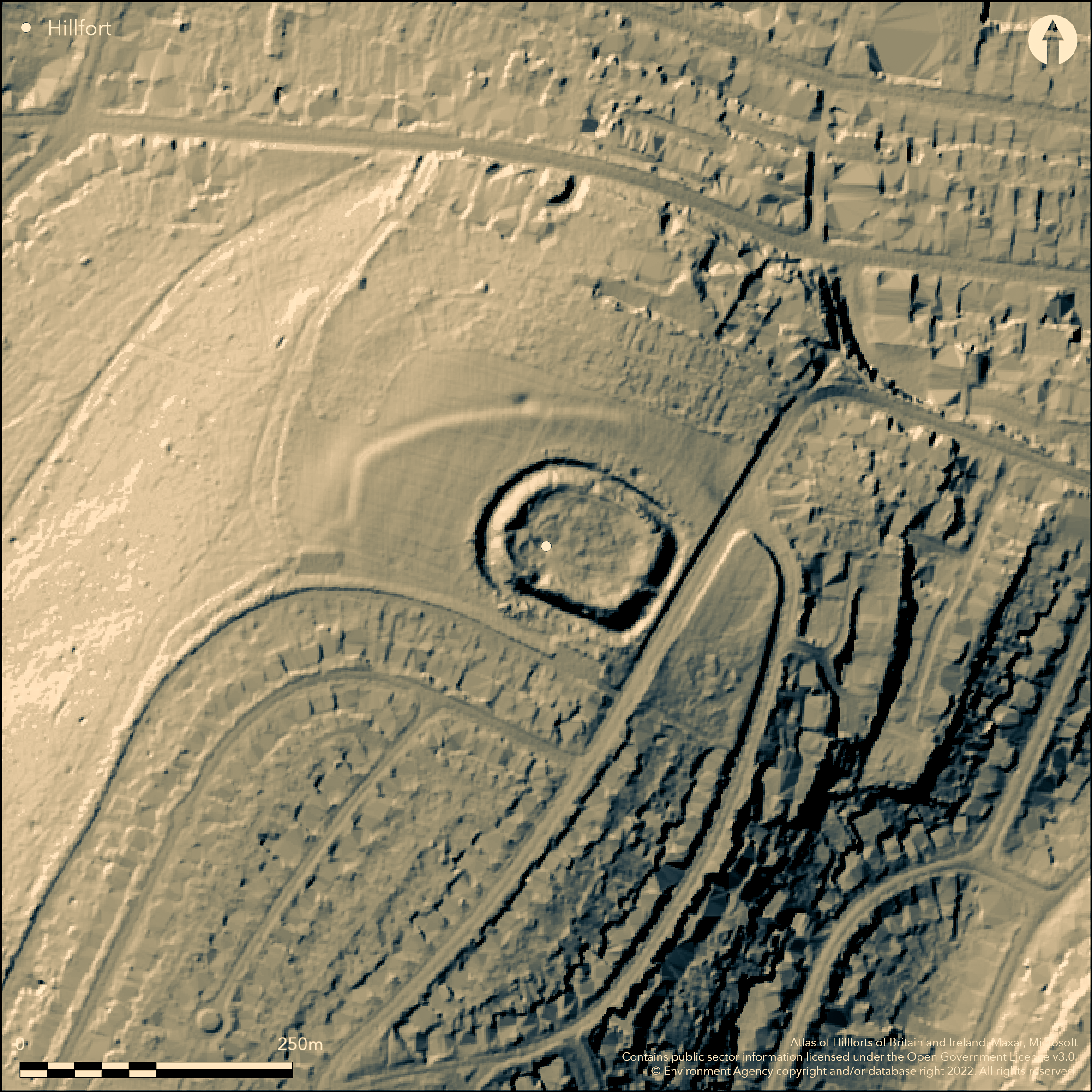
LiDAR 1m DTM Hillshade
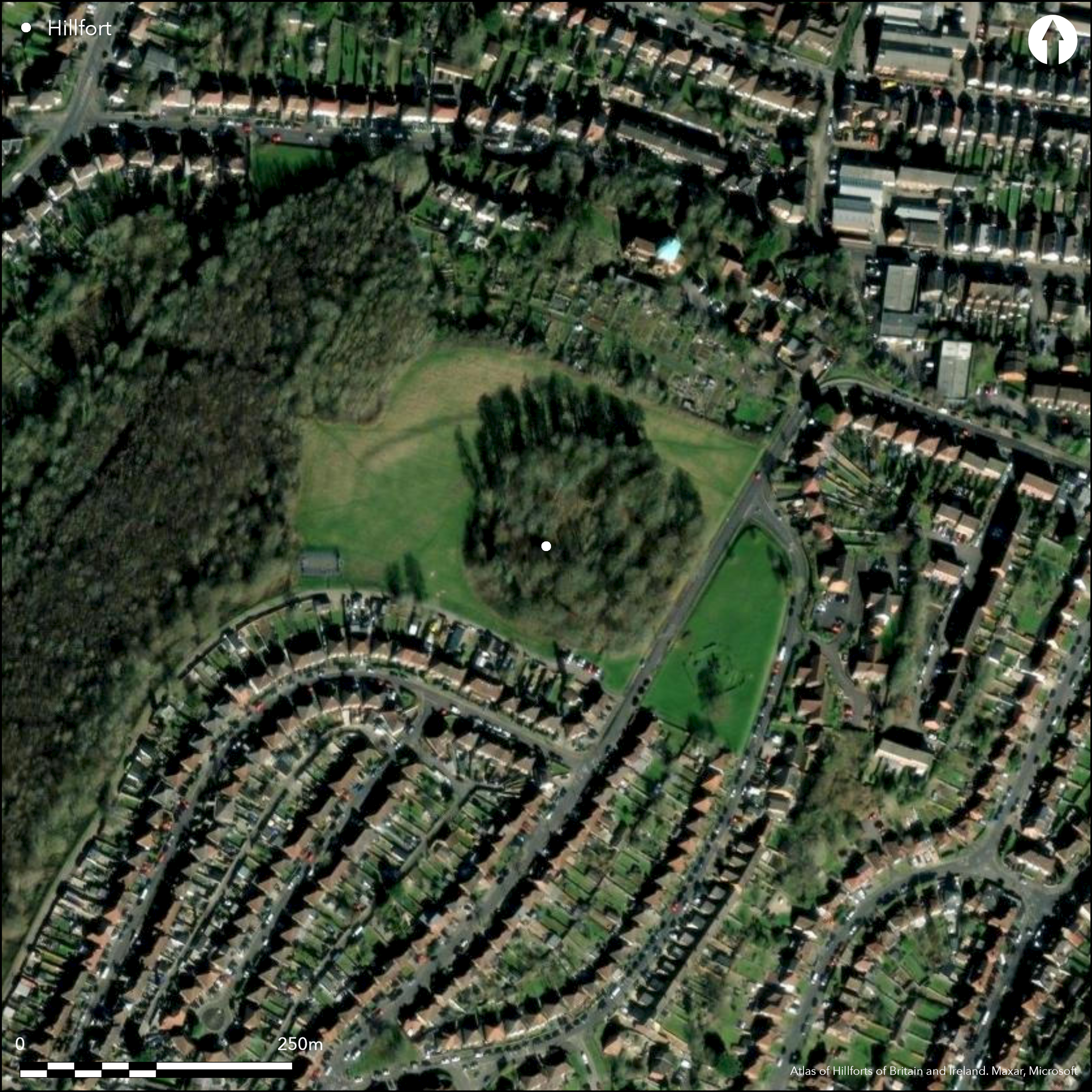
Satellite Imagery
LiDAR 1m DTM Hillshade
Satellite Imagery
Scroll left/right to view further images.
HER: Buckinghamshire 1801000 (None)
NMR: SU 89 SW 2 (248824)
SM: 1020863
NGR: SU 8469 9330
X: 484690 Y: 193324 (OSGB36)
On the site of Desborough Castle, High Wycombe, the earthworks of a scarp, first proposed as the remains of a possible hillfort by Alcroft (1908, 42), lying outside the medieval earthworks. The site lies on a spur at 130m OD overlooking the valley of the River Wye. The earthworks form an irregular arc running NW to NE, lying between 30-70m away from the castle earthworks, following the contour of the hill. In the N they survive as a spread rampart 10m wide and up to 1.5m high externally, and 0.3m high above the interior, and in the NW as a 40m length of ditch 5m wide and 0.2m deep. Now under modern housing in the S and cut by Rutland Avenue in the E. Booker Lane to the E of Rutland Avenue, which is recorded on historic OS mapping, appears to follow the proposed curve of the earthworks in the NE. 2010 satellite imagery appears to show the earthworks turning outwards towards woodland in the SW. Excavations through a section of the earthwork in 1968 (Saunders 1971) produced evidence for two ditches, the innermost being the primary rampart and ditch with the second bank and ditch constructed over the silting of the original ditch. Neither had dateable material, but supported an observation by Downs (1878) of two banks lying outside the medieval earthworks. In 1987 part of the outer earthwork bordering Booker Lane was sectioned in the SE (Collard 1988). No evidence for a former ditch was found but it was concluded that this earthwork was a field lynchet that had developed against the line of the former bank. The castle ringworks now occupy the interior of the hillfort. The ringwork ditch has cut through a suspected bowl barrow 24m across and 7m high. The borough element in the placename suggests the site was significant in the Saxon period or was named from an earlier fortification. The line of the earthworks, appearing much as seen on satellite imagery, is recorded on 1876 1:2,500 OS mapping. A further length of ditch is shown running from the S of Booker Lane into woodland in the E. A break lies towards the eastern end with slightly offset terminals. Now under modern housing. Included in the scheduling for Desborough Castle
Citizen Science: ✓
Reliability of Data: Confirmed
Reliability of Interpretation: Unconfirmed
X: -86580 Y: 6733914 (EPSG: 3857)
Longitude: -0.7777630779931061 Latitude: 51.6323127391564 (EPSG:4326)
Country: England
Current County or Unitary Authority: Buckinghamshire
Historic County: Buckinghamshire
Current Parish/Community/Council/Townland: High Wycombe
Visible on satellite imagery
| Extant | ✓ |
| Cropmark | ✓ |
| Likely Destroyed | ✓ |
None
| Woodland | ✓ |
| Commercial Forestry Plantation | ✗ |
| Parkland | ✓ |
| Pasture (Grazing) | ✗ |
| Arable | ✗ |
| Scrub/Bracken | ✗ |
| Bare Outcrop | ✗ |
| Heather/Moorland | ✗ |
| Heath | ✗ |
| Built-up | ✗ |
| Coastal Grassland | ✗ |
| Other | ✗ |
A possible former partial contour fort lying on a N-sloping spur at 130m OD. The immediate ground slopes more gently in the E and W and rises in the S.
| Contour Fort | ✗ |
| Partial Contour Fort | ✓ |
| Promontory Fort | ✗ |
| Hillslope Fort | ✓ |
| Level Terrain Fort | ✗ |
| Marsh Fort | ✗ |
| Multiple Enclosure Fort | ✗ |
| Hilltop | ✗ |
| Coastal Promontory | ✗ |
| Inland Promontory | ✗ |
| Valley Bottom | ✗ |
| Knoll/Hillock/Outcrop | ✗ |
| Ridge | ✗ |
| Cliff/Plateau-edge/Scarp | ✗ |
| Hillslope | ✓ |
| Lowland | ✗ |
| Spur | ✓ |
Dominant Topographic Feature: Spur
| North | ✓ |
| Northeast | ✗ |
| East | ✗ |
| Southeast | ✗ |
| South | ✗ |
| Southwest | ✗ |
| West | ✗ |
| Northwest | ✗ |
| Level | ✗ |
Altitude: 130.0m
N/A
The earthworks are undated. Flints recovered from the surface and during an excavation in 1988, suggesting Mesolithic, late Neolithic and early Bronze Age activity. Bronze Age barrow cut by medieval ramparts. Barrow mound, thought to have been later used as a moot for the Desborough Hundred. Roman pottery and tile and a Roman 'Belgic' brooch recovered during investigations of the castle earthworks. Medieval ringwork of Desborough Castle.
Reliability: D - None
| Pre 1200BC | ✗ |
| 1200BC - 800BC | ✗ |
| 800BC - 400BC | ✗ |
| 400BC - AD50 | ✗ |
| AD50 - AD400 | ✗ |
| AD400 - AD 800 | ✗ |
| Post AD800 | ✗ |
| Unknown | ✓ |
| Pre Hillfort: | None |
| Post Hillfort: | None |
Recorded on 1876 1:2,500 OS mapping. Field investigation 1962 and 1974. Excavations in 1967 and 1987. Included in the scheduling for Desborough Castle
| 1st Identified Map Depiction (1876): | None |
| 1st Identified Written Reference (1878): | None |
| Other (1933): | Scheduled |
| Other (1967): | Field investigation |
| Excavation (1968): | None |
| Excavation (1987): | None |
| Other (1987): | Field investigation |
No internal features contemporary with the Iron Age earthworks are recorded. The remains of a possible bowl barrow and the earthworks of Desborough Castle occupy the interior. Modern housing in the S and E. A modern road (Rutland Avenue) runs N-S through the enclosure. Pottery.
River Wye 400m to the S
| None | ✓ |
| Spring | ✗ |
| Stream | ✗ |
| Pool | ✗ |
| Flush | ✗ |
| Well | ✗ |
| Other | ✗ |
None
| No Known Features | ✓ |
| Round Stone Structures | ✗ |
| Rectangular Stone Structures | ✗ |
| Curvilinear Platforms | ✗ |
| Other Roundhouse Evidence | ✗ |
| Pits | ✗ |
| Quarry Hollows | ✗ |
| Other | ✗ |
Enclosing works only excavated
| No Known Excavation | ✓ |
| Pits | ✗ |
| Postholes | ✗ |
| Roundhouses | ✗ |
| Rectangular Structures | ✗ |
| Roads/Tracks | ✗ |
| Quarry Hollows | ✗ |
| Other | ✗ |
| Nothing Found | ✗ |
None
| No Known Geophysics | ✓ |
| Pits | ✗ |
| Roundhouses | ✗ |
| Rectangular Structures | ✗ |
| Roads/Tracks | ✗ |
| Quarry Hollows | ✗ |
| Other | ✗ |
| Nothing Found | ✗ |
None
| No Known Finds | ✗ |
| Pottery | ✓ |
| Metal | ✗ |
| Metalworking | ✗ |
| Human Bones | ✗ |
| Animal Bones | ✗ |
| Lithics | ✓ |
| Environmental | ✗ |
| Other | ✗ |
None
| APs Not Checked | ✓ |
| None | ✗ |
| Roundhouses | ✗ |
| Rectangular Structures | ✗ |
| Pits | ✗ |
| Postholes | ✗ |
| Roads/Tracks | ✗ |
| Other | ✗ |
The location of original entrances is unknown
| 2: | Modern Road |
| 2: | None |
Guard Chambers: ✗
Chevaux de Frise: ✗
The earthworks form an irregular arc running NW to NE, lying between 30-70m away from the castle earthworks, following the contour of the hill. In the N they survive as a spread rampart 10m wide and up to 1.5m high externally, and 0.3m high above the interior, and in the NW as a 40m length of ditch 5m wide and 0.2m deep. Under modern housing in the S and cut by Rutland Avenue in the E. Booker Lane to the E of Rutland Avenue appears to follow the proposed curve of the earthworks in the NE. Excavations through a section of the earthworks (Saunders 1971) produced evidence for two ditches, the innermost being the primary rampart and ditch with the second bank and ditch constructed over the silting of the original ditch. Neither had dateable material, but supported an observation by Downs (1878) of two banks lying outside the medieval earthworks. In 1987 part of the outer earthwork bordering Booker Lane was sectioned in the SE (Collard 1988). No evidence for a former ditch was found but it was concluded that this earthwork was a field lynchet that had developed against the line of the former bank.
| Area 1: | Noneha. |
| Total: | Noneha. |
Total Footprint Area: Noneha.
None
| ✓ | The full extent of the earthworks is unknown. Farley (2009, 238) proposes the outer ditch, extended beyond Booker Lane in the S possibly with a return in the region where Cross Lane now lies, enclosing a much larger area. The site is now under housing and cannot be confirmed. |
| ✗ | None |
| NE Quadrant: | 1 |
| SE Quadrant: | None |
| SW Quadrant: | None |
| NW Quadrant: | 1 |
| Total: | 1 |
| Partial Univallate | ✓ |
| Univallate | ✗ |
| Partial Bivallate | ✗ |
| Bivallate | ✗ |
| Partial Multivallate | ✗ |
| Multivallate | ✗ |
| Unknown | ✗ |
| Partial Univallate | ✗ |
| Univallate | ✗ |
| Partial Bivallate | ✗ |
| Bivallate | ✗ |
| Partial Multivallate | ✗ |
| Multivallate | ✗ |
None
| None | ✗ |
| Earthen Bank | ✓ |
| Stone Wall | ✗ |
| Rubble | ✗ |
| Wall-walk | ✗ |
| Evidence of Timber | ✗ |
| Vitrification | ✗ |
| Other Burning | ✗ |
| Palisade | ✗ |
| Counter Scarp Bank | ✗ |
| Berm | ✗ |
| Unfinished | ✗ |
| Other | ✗ |
None
| None | ✗ |
| Earthen Bank | ✓ |
| Stone Wall | ✗ |
| Murus Duplex | ✗ |
| Timber-framed | ✗ |
| Timber-laced | ✗ |
| Vitrification | ✗ |
| Other Burning | ✗ |
| Palisade | ✗ |
| Counter Scarp Bank | ✗ |
| Berm | ✗ |
| Unfinished | ✗ |
| No Known Excavation | ✗ |
| Other | ✗ |
| ✗ | None |
| ✓ | None |
Number of Ditches: 2
| ✗ | None |
Allcroft, A. H. 1908. Earthwork of England. MacMillan: London
Collard, M. 1988. Excavations at Desborough Castle, High Wycombe, 1987. Rec Buckinghamshire 18, 15-52
Downs, R.S. 1878. Desborough Castle. Rec Buckinghamshire 5, 248-60
Farley, M. 2009. How large was the Iron Age 'hillfort' at Desborough Castle, West Wycombe? Rec Buckinghamshire 49, 235-238
Saunders, C. 1971. The pre-Belgic Iron Age in the central and western Chilterns. Arch J. 128, 1-30
Atlas of Hillforts:
Wikidata:
This work is licensed under CC BY-SA 4.0

 and should be cited as:
Lock, Gary and Ralston, Ian. 2024. Atlas of Hillforts of Britain and Ireland. Available at: https://hillforts.arch.ox.ac.uk
Document Version 1.1