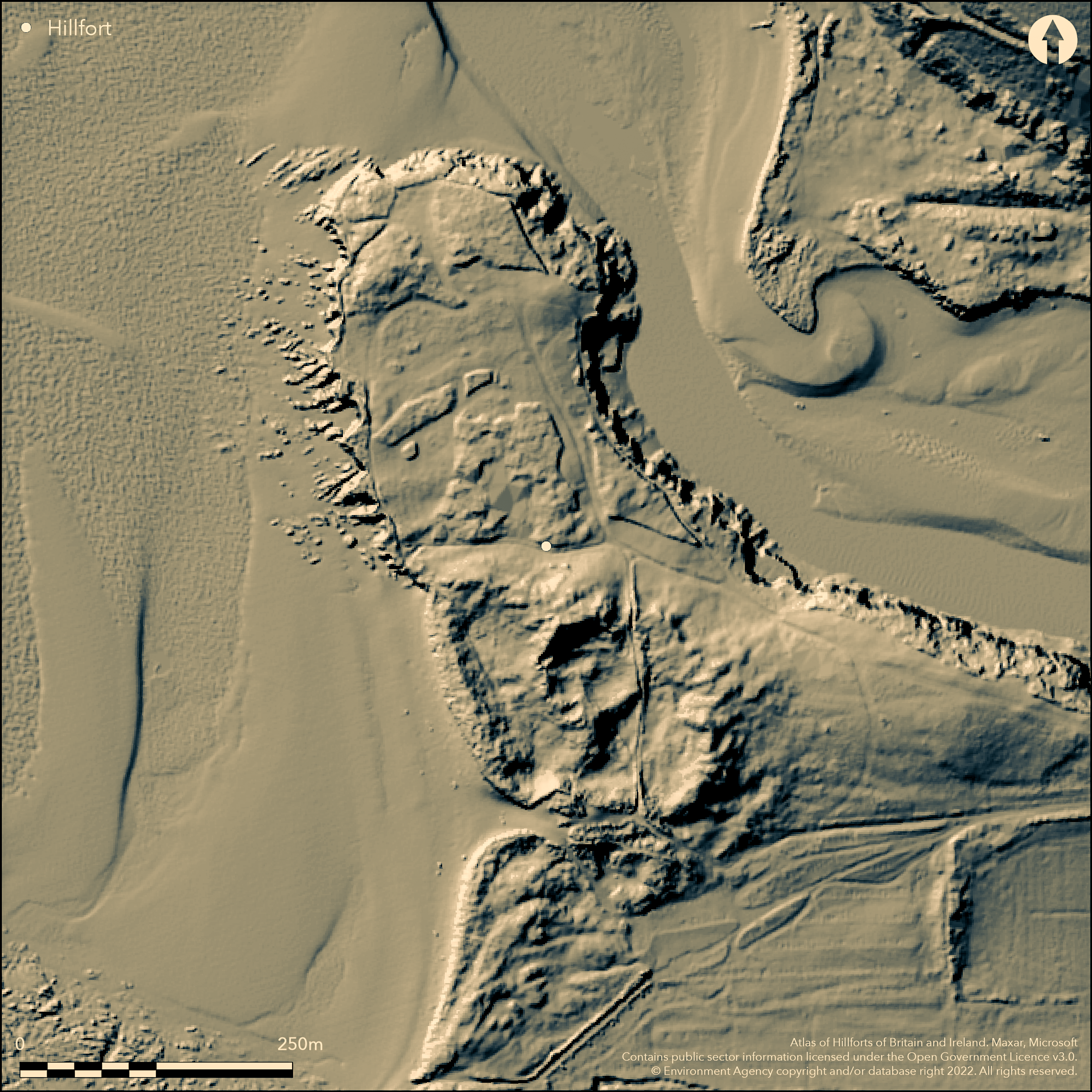
LiDAR 1m DTM Hillshade
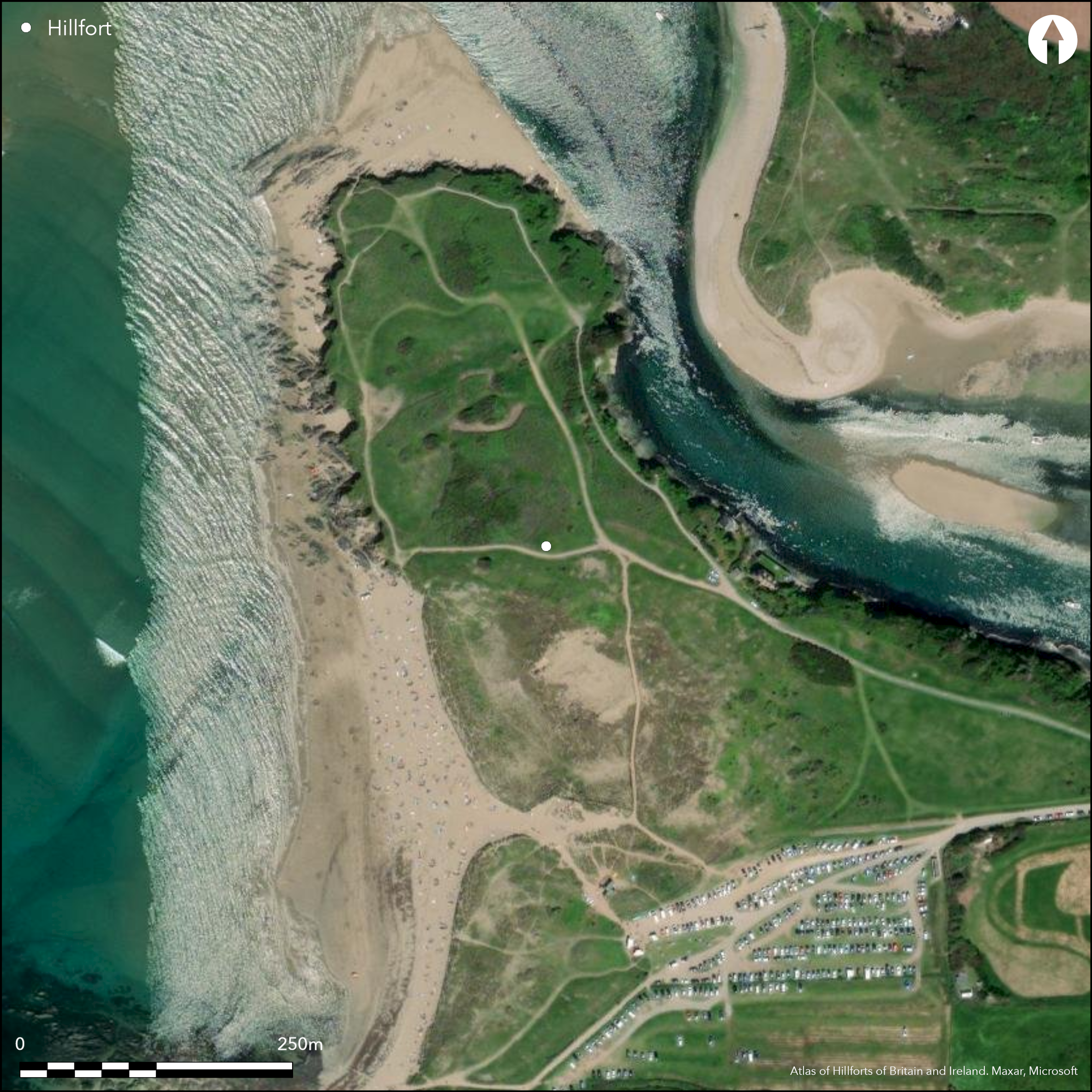
Satellite Imagery
LiDAR 1m DTM Hillshade
Satellite Imagery
Scroll left/right to view further images.
HER: Devon MDV2807 (None)
NMR: SX 64 SE 21 (441090)
SM: 1019322
NGR: SX66324390
X: 266314 Y: 43903 (OSGB36)
Possible inland promontory fort located on prominent NNW--facing promontory at mouth of River Avon to N. Rocky coast, sea and river to N and W and coastal marsh to S. Enclosed area not defined. Ramparts on Bantham Ham have been identified in past as rectangular Roman Camp, as scheduled, or Iron Age promontory fort. No rampartss visible on site and much shifting sand confuses matters. S of the Buckland Stream, low marsh and possible short length of rampart near shoreline. Excavations 1978 and 1997. Some late Roman or medieval, earthworks. No dating for prehistoric promontory fort, but, Bronze Age arrowheads and Iron Age pottery found. Much evidence for site as Roman trading centre. At best, the site as promontory fort can be termed 'possible'. Burnt piles also have been found in the marsh. Site buried by sand dunes and popular holiday site and part car park. On 1st Ed. OS map (1887).
Citizen Science: ✗
Reliability of Data: Unconfirmed
Reliability of Interpretation: Unconfirmed
X: -431664 Y: 6494881 (EPSG: 3857)
Longitude: -3.877707024384644 Latitude: 50.27984212718437 (EPSG:4326)
Country: England; None
Current County or Unitary Authority: Devon
Historic County: Devon
Current Parish/Community/Council/Townland: Thurlstone; Bigbury
Much erosion of shoreline and shifting sand. Past management of dunes attempted. Site buried by sand dunes and popular holiday site and part car park. WWII pill-boxes - one removed, and later lifeguard station.
| Extant | ✗ |
| Cropmark | ✗ |
| Likely Destroyed | ✓ |
Coastal sand dunes. Part car park. WWII pill-boxes - one removed, and later lifeguard station.
| Woodland | ✗ |
| Commercial Forestry Plantation | ✗ |
| Parkland | ✗ |
| Pasture (Grazing) | ✗ |
| Arable | ✗ |
| Scrub/Bracken | ✗ |
| Bare Outcrop | ✗ |
| Heather/Moorland | ✗ |
| Heath | ✗ |
| Built-up | ✓ |
| Coastal Grassland | ✗ |
| Other | ✓ |
Possible inland promontory fort located on prominent NNW--facing promontory at mouth of River Avon to N quadrants. Rocky coast, sea and river to N and W and coastal marsh to S.
| Contour Fort | ✗ |
| Partial Contour Fort | ✗ |
| Promontory Fort | ✓ |
| Hillslope Fort | ✗ |
| Level Terrain Fort | ✗ |
| Marsh Fort | ✗ |
| Multiple Enclosure Fort | ✗ |
| Hilltop | ✗ |
| Coastal Promontory | ✓ |
| Inland Promontory | ✗ |
| Valley Bottom | ✗ |
| Knoll/Hillock/Outcrop | ✗ |
| Ridge | ✗ |
| Cliff/Plateau-edge/Scarp | ✗ |
| Hillslope | ✗ |
| Lowland | ✗ |
| Spur | ✗ |
Dominant Topographic Feature: Sand dunes.
| North | ✗ |
| Northeast | ✗ |
| East | ✗ |
| Southeast | ✗ |
| South | ✗ |
| Southwest | ✗ |
| West | ✗ |
| Northwest | ✓ |
| Level | ✗ |
Altitude: 30.0m
Boundary Type: Parish/Townland
No dating for prehistoric promontory fort, but, Bronze Age arrowheads and Iron Age pottery found. Much evidence for site as Roman trading centre.
Reliability: D - None
| Pre 1200BC | ✗ |
| 1200BC - 800BC | ✗ |
| 800BC - 400BC | ✗ |
| 400BC - AD50 | ✗ |
| AD50 - AD400 | ✗ |
| AD400 - AD 800 | ✗ |
| Post AD800 | ✗ |
| Unknown | ✓ |
| Pre Hillfort: | Neolithic polished stone axe. |
| Post Hillfort: | Much evidence for site as Roman trading centre, including imported amphorae from E Mediterranean and N African red slipped tablewares. Late Roman or post Roman bone and pottery including spindle whorls, bone combs and amphora sherds of fifth to seventh centuries AD. Some late Roman or medieval, earthworks. WWII pill-box and later lifeguard station. |
| Artefactual: | Late Roman or post Roman. |
| Morphology/Earthwork/Typology: | Late Roman and medieval earthworks. |
On 1st Ed. OS map (1887). Excavation 1978 - no details. Watching brief 1982. Excavation 1997 F.M. Griffith and S.J. Reed. Watching brief 1997. MPP fieldwork R. Waterhouse 1999.
| 1st Identified Map Depiction (1887): | OS map. |
| Excavation (1978): | No details. |
| Other (1982): | Watching Brief - no details. |
| Excavation (1997): | F.M. Griffith and S.J. Reed. |
| Other (1997): | Watching brief - no details. |
| Other (1999): | MPP fieldwork R. Waterhouse. |
Evidence for late Roman and medieval banks and structures. Bronze Age arrowheads and Iron Age pottery found.
None
| None | ✓ |
| Spring | ✗ |
| Stream | ✗ |
| Pool | ✗ |
| Flush | ✗ |
| Well | ✗ |
| Other | ✗ |
Nothing visible.
| No Known Features | ✓ |
| Round Stone Structures | ✗ |
| Rectangular Stone Structures | ✗ |
| Curvilinear Platforms | ✗ |
| Other Roundhouse Evidence | ✗ |
| Pits | ✗ |
| Quarry Hollows | ✗ |
| Other | ✗ |
Evidence for late Roman and medieval banks and structures.
| No Known Excavation | ✗ |
| Pits | ✗ |
| Postholes | ✗ |
| Roundhouses | ✗ |
| Rectangular Structures | ✗ |
| Roads/Tracks | ✗ |
| Quarry Hollows | ✗ |
| Other | ✗ |
| Nothing Found | ✓ |
None
| No Known Geophysics | ✓ |
| Pits | ✗ |
| Roundhouses | ✗ |
| Rectangular Structures | ✗ |
| Roads/Tracks | ✗ |
| Quarry Hollows | ✗ |
| Other | ✗ |
| Nothing Found | ✗ |
Bronze Age arrowheads and Iron Age pottery found.
| No Known Finds | ✗ |
| Pottery | ✓ |
| Metal | ✗ |
| Metalworking | ✗ |
| Human Bones | ✗ |
| Animal Bones | ✗ |
| Lithics | ✓ |
| Environmental | ✗ |
| Other | ✗ |
None
| APs Not Checked | ✓ |
| None | ✗ |
| Roundhouses | ✗ |
| Rectangular Structures | ✗ |
| Pits | ✗ |
| Postholes | ✗ |
| Roads/Tracks | ✗ |
| Other | ✗ |
Nothing visible.
| 0: | None |
| 2: | None |
Guard Chambers: ✗
Chevaux de Frise: ✗
Nothing prehistoric visible. Evidence for late Roman and medieval banks.
| Area 1: | Noneha. |
| Total: | Noneha. |
Total Footprint Area: Noneha.
None
| ✗ | Area not defined. |
| ✗ | Nothing visible. |
| NE Quadrant: | 0 |
| SE Quadrant: | 0 |
| SW Quadrant: | 0 |
| NW Quadrant: | 0 |
| Total: | 0 |
| Partial Univallate | ✗ |
| Univallate | ✗ |
| Partial Bivallate | ✗ |
| Bivallate | ✗ |
| Partial Multivallate | ✗ |
| Multivallate | ✗ |
| Unknown | ✓ |
| Partial Univallate | ✗ |
| Univallate | ✗ |
| Partial Bivallate | ✗ |
| Bivallate | ✗ |
| Partial Multivallate | ✗ |
| Multivallate | ✗ |
Nothing visible.
| None | ✓ |
| Earthen Bank | ✗ |
| Stone Wall | ✗ |
| Rubble | ✗ |
| Wall-walk | ✗ |
| Evidence of Timber | ✗ |
| Vitrification | ✗ |
| Other Burning | ✗ |
| Palisade | ✗ |
| Counter Scarp Bank | ✗ |
| Berm | ✗ |
| Unfinished | ✗ |
| Other | ✗ |
Nothing prehistoric found. Evidence for late Roman and medieval banks.
| None | ✓ |
| Earthen Bank | ✗ |
| Stone Wall | ✗ |
| Murus Duplex | ✗ |
| Timber-framed | ✗ |
| Timber-laced | ✗ |
| Vitrification | ✗ |
| Other Burning | ✗ |
| Palisade | ✗ |
| Counter Scarp Bank | ✗ |
| Berm | ✗ |
| Unfinished | ✗ |
| No Known Excavation | ✗ |
| Other | ✗ |
| ✗ | None |
| ✗ | Nothing visible. |
Number of Ditches: 0
| ✗ | None |
Allcroft, E.H. 1908. Earthwork of England : prehistoric, Roman, Saxon, Danish, Norman, and mediaeval, 186.
Fox, A. 1955. A Dark Age trading site at Bantham, Antiq J, 35, 53-67.
Griffith, F M, 1986. Salvage observations at the Dark Age site at Bantham Ham In 1982, Proc. Devon Archaeol. Soc, 44, 39-57.
Wall, J.C. 1906. Ancient Earthworks, In W. Page (ed), The Victoria County History of the County of Devon, Vol I, London: James Street, Haymarket, 580.
Atlas of Hillforts:
Wikidata:
This work is licensed under CC BY-SA 4.0

 and should be cited as:
Lock, Gary and Ralston, Ian. 2024. Atlas of Hillforts of Britain and Ireland. Available at: https://hillforts.arch.ox.ac.uk
Document Version 1.1