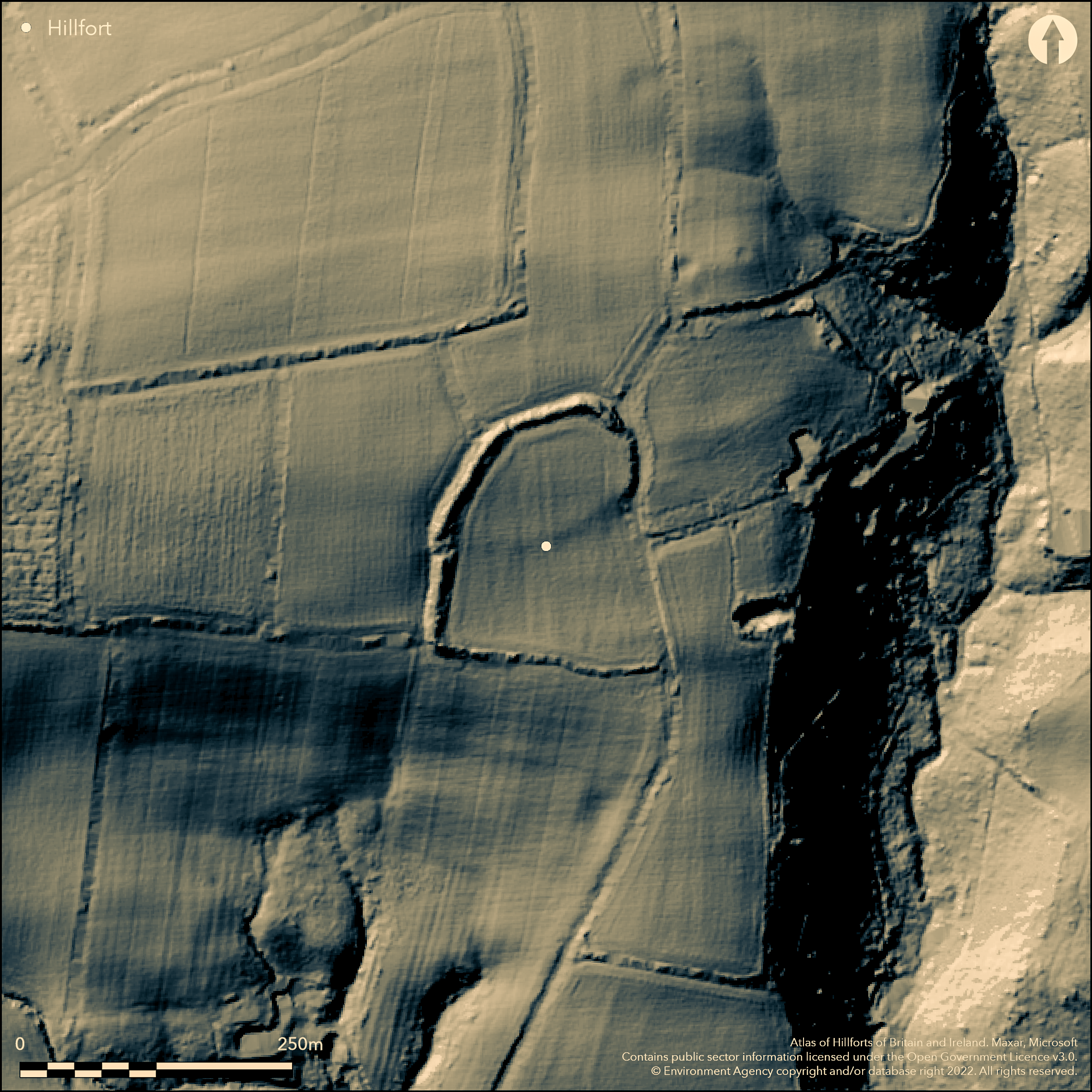
LiDAR 1m DTM Hillshade
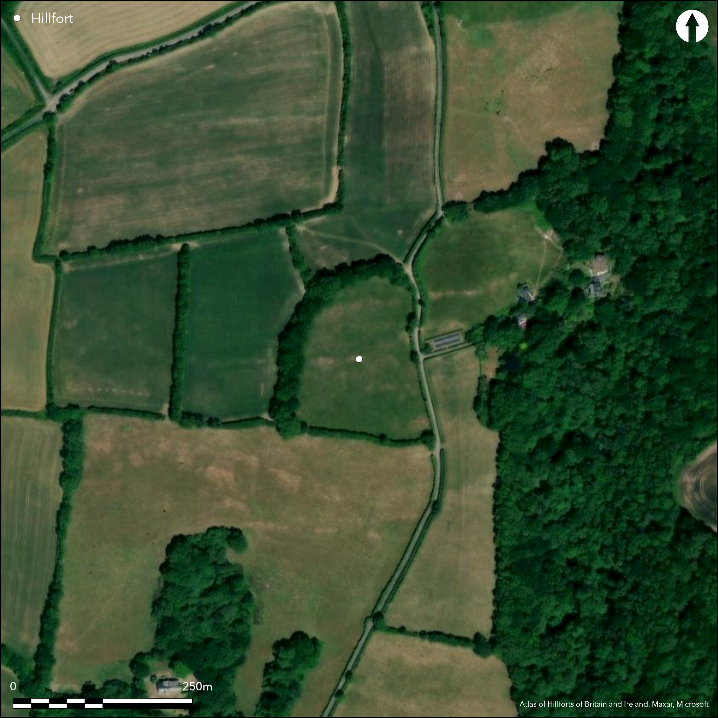
Satellite Imagery
LiDAR 1m DTM Hillshade
Satellite Imagery
Scroll left/right to view further images.
HER: Devon MDV634 (None)
NMR: SS 80 NW 2 (35514)
SM: 1019541
NGR: SS80160926
X: 280171 Y: 109272 (OSGB36)
Univallate, hillslope fort sited on SSE-facing slope, just beneath summit of ridge, overlooking valley of tributary of River Creedy. Steep to moderate to strong surrounding slopes E, S and W, moderate to ridge summit on NNW. D-shaped, enclosed area measures 125m N-S by 95m of c. 1.2ha. the site sloping gently to S before steep slopes. Defined by rampart and ditch on N and W, where rampart up to 3m externally and, mostly filled, ditch 6.5m wide and 0.5m deep. To E and S rampart incorporated into field boundaries, on E to 1.1m high and S to 1.5m high. To E and S ditch buried feature. Banks and ditches much affected by modern entrance gaps and access roads. At NW apex old established field access. Simple splayed causewayed entrance through rampart on W, to 10.4m wide and blocked for some time, probably original. Another access gate in centre of S side. To E, where rampart part of field boundary, this and outer ditch cut by access road running alongside. Another field access entrance on E, defined by slightly incurving low banks beside gate where bank incorporated into field boundary may be original, but uncertain. Buried ditch on E also cut by the road. Improved pasture with trees/hedge/scrub on field boundaries. On 1st Ed. OS map (1890). Minimal investigations, undated.
Citizen Science: ✗
Reliability of Data: Confirmed
Reliability of Interpretation: Confirmed
X: -412371 Y: 6598407 (EPSG: 3857)
Longitude: -3.7043930237320004 Latitude: 50.870432013131 (EPSG:4326)
Country: England
Current County or Unitary Authority: Devon
Historic County: Devon
Current Parish/Community/Council/Townland: Woolfardisworthy
Ditch buried feature on E and S. Damaged by access road on E.
| Extant | ✓ |
| Cropmark | ✗ |
| Likely Destroyed | ✗ |
Improved pasture with trees/hedge/scrub on field boundaries. Access road.
| Woodland | ✓ |
| Commercial Forestry Plantation | ✗ |
| Parkland | ✗ |
| Pasture (Grazing) | ✓ |
| Arable | ✗ |
| Scrub/Bracken | ✓ |
| Bare Outcrop | ✗ |
| Heather/Moorland | ✗ |
| Heath | ✗ |
| Built-up | ✗ |
| Coastal Grassland | ✗ |
| Other | ✓ |
Univallate, hillslope fort sited on SSE-facing slope, just beneath summit of ridge, overlooking valley of tributary of River Creedy. Steep to moderate to strong surrounding slopes E, S and W, moderate to ridge summit on NNW. Site slopes gently before steep slopes.
| Contour Fort | ✗ |
| Partial Contour Fort | ✗ |
| Promontory Fort | ✗ |
| Hillslope Fort | ✓ |
| Level Terrain Fort | ✗ |
| Marsh Fort | ✗ |
| Multiple Enclosure Fort | ✗ |
| Hilltop | ✗ |
| Coastal Promontory | ✗ |
| Inland Promontory | ✗ |
| Valley Bottom | ✗ |
| Knoll/Hillock/Outcrop | ✗ |
| Ridge | ✗ |
| Cliff/Plateau-edge/Scarp | ✗ |
| Hillslope | ✓ |
| Lowland | ✗ |
| Spur | ✗ |
Dominant Topographic Feature: Hillslope
| North | ✗ |
| Northeast | ✗ |
| East | ✗ |
| Southeast | ✓ |
| South | ✗ |
| Southwest | ✗ |
| West | ✗ |
| Northwest | ✗ |
| Level | ✗ |
Altitude: 183.0m
N/A
None.
Reliability: D - None
| Pre 1200BC | ✗ |
| 1200BC - 800BC | ✗ |
| 800BC - 400BC | ✗ |
| 400BC - AD50 | ✗ |
| AD50 - AD400 | ✗ |
| AD400 - AD 800 | ✗ |
| Post AD800 | ✗ |
| Unknown | ✓ |
| Pre Hillfort: | None |
| Post Hillfort: | None |
On 1st Ed. OS map (1890).
| 1st Identified Map Depiction (1890): | OS map. |
None.
None
| None | ✓ |
| Spring | ✗ |
| Stream | ✗ |
| Pool | ✗ |
| Flush | ✗ |
| Well | ✗ |
| Other | ✗ |
None
| No Known Features | ✓ |
| Round Stone Structures | ✗ |
| Rectangular Stone Structures | ✗ |
| Curvilinear Platforms | ✗ |
| Other Roundhouse Evidence | ✗ |
| Pits | ✗ |
| Quarry Hollows | ✗ |
| Other | ✗ |
None
| No Known Excavation | ✓ |
| Pits | ✗ |
| Postholes | ✗ |
| Roundhouses | ✗ |
| Rectangular Structures | ✗ |
| Roads/Tracks | ✗ |
| Quarry Hollows | ✗ |
| Other | ✗ |
| Nothing Found | ✗ |
None
| No Known Geophysics | ✓ |
| Pits | ✗ |
| Roundhouses | ✗ |
| Rectangular Structures | ✗ |
| Roads/Tracks | ✗ |
| Quarry Hollows | ✗ |
| Other | ✗ |
| Nothing Found | ✗ |
None
| No Known Finds | ✓ |
| Pottery | ✗ |
| Metal | ✗ |
| Metalworking | ✗ |
| Human Bones | ✗ |
| Animal Bones | ✗ |
| Lithics | ✗ |
| Environmental | ✗ |
| Other | ✗ |
None
| APs Not Checked | ✓ |
| None | ✗ |
| Roundhouses | ✗ |
| Rectangular Structures | ✗ |
| Pits | ✗ |
| Postholes | ✗ |
| Roads/Tracks | ✗ |
| Other | ✗ |
Banks and ditches much affected by modern entrance gaps. At NW apex old established field access. Simple splayed causewayed entrance through rampart on W, to 10.4m wide and blocked for some time, possibly original. Another field access entrance on E, defined by slightly incurving low banks beside gate where bank incorporated into field boundary, may be original, but uncertain.
| 4: | Field entrances on NW and S modern |
| 2: | Possibly E and W entrances, but former uncertain. |
Guard Chambers: ✗
Chevaux de Frise: ✗
| 1. Simple Gap (West): | Splayed causewayed entrance. |
| 1. Blocked (West): | Blocked for some time. |
| 2. In-turned (East): | Slightly incurving. May be original entrance, but uncertain. |
Defined by rampart and ditch on N and W, where rampart up to 3m externally and, mostly filled, ditch 6.5m wide and 0.5m deep. To E and S rampart incorporated into field boundaries, on E to 1.1m high and S to 1.5m high. To E and S ditch buried feature. Banks and ditches much affected by modern entrance gaps and access roads.
| Area 1: | 1.2ha. |
| Total: | 1.2ha. |
Total Footprint Area: Noneha.
None
| ✗ | None |
| ✓ | None |
| NE Quadrant: | 1 |
| SE Quadrant: | 1 |
| SW Quadrant: | 1 |
| NW Quadrant: | 1 |
| Total: | 1 |
| Partial Univallate | ✗ |
| Univallate | ✓ |
| Partial Bivallate | ✗ |
| Bivallate | ✗ |
| Partial Multivallate | ✗ |
| Multivallate | ✗ |
| Unknown | ✗ |
| Partial Univallate | ✗ |
| Univallate | ✗ |
| Partial Bivallate | ✗ |
| Bivallate | ✗ |
| Partial Multivallate | ✗ |
| Multivallate | ✗ |
None
| None | ✗ |
| Earthen Bank | ✓ |
| Stone Wall | ✗ |
| Rubble | ✗ |
| Wall-walk | ✗ |
| Evidence of Timber | ✗ |
| Vitrification | ✗ |
| Other Burning | ✗ |
| Palisade | ✗ |
| Counter Scarp Bank | ✗ |
| Berm | ✗ |
| Unfinished | ✗ |
| Other | ✗ |
None
| None | ✗ |
| Earthen Bank | ✗ |
| Stone Wall | ✗ |
| Murus Duplex | ✗ |
| Timber-framed | ✗ |
| Timber-laced | ✗ |
| Vitrification | ✗ |
| Other Burning | ✗ |
| Palisade | ✗ |
| Counter Scarp Bank | ✗ |
| Berm | ✗ |
| Unfinished | ✗ |
| No Known Excavation | ✓ |
| Other | ✗ |
| ✗ | None |
| ✓ | To E and S ditch buried feature. |
Number of Ditches: 1
| ✗ | None |
Wall, J.C. 1906. Ancient Earthworks, In W. Page (ed), The Victoria County History of the County of Devon, Vol I, London: James Street, Haymarket, 613.
Atlas of Hillforts:
Wikidata:
This work is licensed under CC BY-SA 4.0

 and should be cited as:
Lock, Gary and Ralston, Ian. 2024. Atlas of Hillforts of Britain and Ireland. Available at: https://hillforts.arch.ox.ac.uk
Document Version 1.1