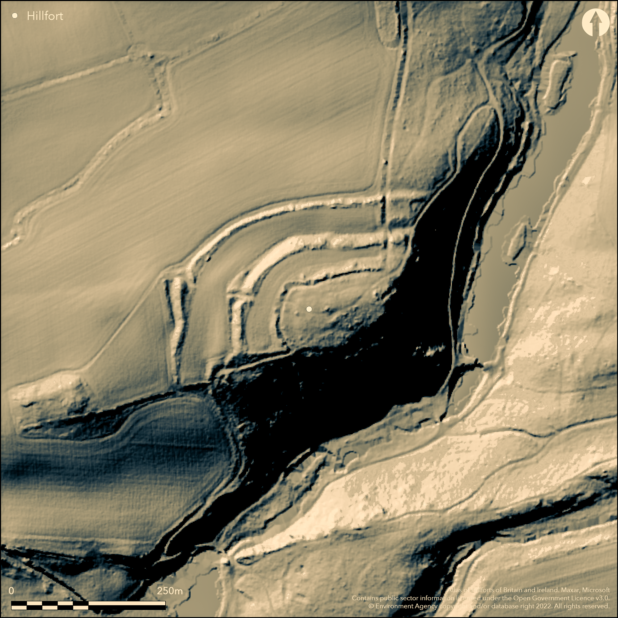
LiDAR 1m DTM Hillshade
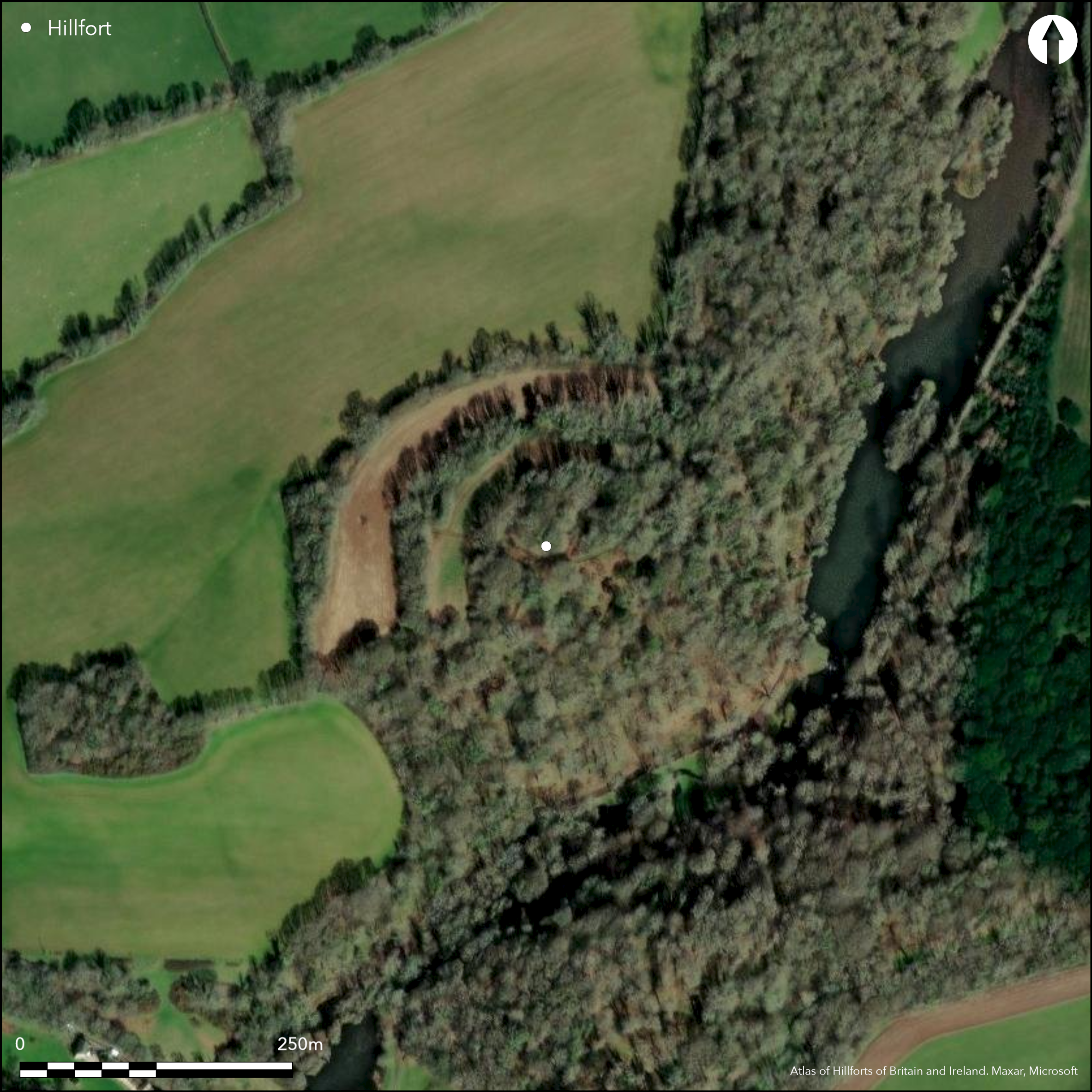
Satellite Imagery
LiDAR 1m DTM Hillshade
Satellite Imagery
Scroll left/right to view further images.
HER: Devon MDV2292 (None)
NMR: SX 55 SE 1 (438459)
SM: 1020160
NGR: SX571539
X: 257176 Y: 53920 (OSGB36)
Multivallate level terrain hillfort located on a broad flat topped spur edge on W side of steep sided valley of small stream Silverbridge Lake, now dammed here to provide ornamental lake. E and S sides fall steeply to stream, with steep slope on SW. On N. the ground falls gently, on W approach almost level to outer bank. Defined by three lines of ramparts on N and W sides 15m-40m apart (possibly a multiple enclosure site) and separated by level ground, but sloping at E and S ends. Much of inner rampart slight, at 4m wide and 1.7m high,with traces of outer ditch 10m wide and 0.2m deep. Middle rampart 10m-18m wide, to 1m from interior and falling 3m to external ditch 6m wide and 0.4m-1m deep. Counterscarp bank on W side 21m wide and falls 2.5m at S end, to a second ditch 8m wide and 0.2m deep. Outer rampart now mainly a scarp, falling between 1m and 3m into outer ditch, 5m-10m wide and to 1m deep, with counterscarp bank to 10m wide and 0.3m high. Outer bank entrance lies on NW with inturned bank on N side, and massive S bank, thickening up 8m wide, and to 2m from interior and falling 4m-5m to the ditch. Middle bank entrance in line with that of outer rampart, with causeway 20m wide crossing the ditch. Possible second entrance at S end of rampart where terminal thickens. Inner rampart entrance in the same position as others, but very slight. Inner rampart re-modelled to form part of the pale for Lyneham deer park in existence by 1610. Within Warren Wood. Rabbit warren on the valley floor on E side of wood and ruin of single-roomed warrener's house within ramparts. Well-preserved despite damage. Minimal investigations, undated.
Citizen Science: ✗
Reliability of Data: Confirmed
Reliability of Interpretation: Confirmed
X: -446355 Y: 6510206 (EPSG: 3857)
Longitude: -4.009675894304136 Latitude: 50.36773251298068 (EPSG:4326)
Country: England; None
Current County or Unitary Authority: Devon
Historic County: Devon
Current Parish/Community/Council/Townland: Brixton; Yealmpton
Well-preserved despite damage. Ruin of single-roomed warrener's house within ramparts. On Heritage at Risk Register (2015).
| Extant | ✓ |
| Cropmark | ✗ |
| Likely Destroyed | ✗ |
Within Warren Wood. Ruin of single-roomed warrener's house within ramparts.
| Woodland | ✓ |
| Commercial Forestry Plantation | ✗ |
| Parkland | ✗ |
| Pasture (Grazing) | ✗ |
| Arable | ✗ |
| Scrub/Bracken | ✗ |
| Bare Outcrop | ✗ |
| Heather/Moorland | ✗ |
| Heath | ✗ |
| Built-up | ✓ |
| Coastal Grassland | ✗ |
| Other | ✗ |
Multivallate level terrain hillfort located on a broad flat topped spur edge on W side of steep sided valley of small stream Silverbridge Lake, now dammed here to provide ornamental lake. E and S sides fall steeply to stream, with steep slope on SW. On N. the ground falls gently, on W approach almost level to outer bank.
| Contour Fort | ✗ |
| Partial Contour Fort | ✗ |
| Promontory Fort | ✗ |
| Hillslope Fort | ✗ |
| Level Terrain Fort | ✓ |
| Marsh Fort | ✗ |
| Multiple Enclosure Fort | ✗ |
| Hilltop | ✗ |
| Coastal Promontory | ✗ |
| Inland Promontory | ✗ |
| Valley Bottom | ✗ |
| Knoll/Hillock/Outcrop | ✗ |
| Ridge | ✗ |
| Cliff/Plateau-edge/Scarp | ✗ |
| Hillslope | ✗ |
| Lowland | ✗ |
| Spur | ✓ |
Dominant Topographic Feature: Spur
| North | ✗ |
| Northeast | ✗ |
| East | ✗ |
| Southeast | ✗ |
| South | ✗ |
| Southwest | ✗ |
| West | ✗ |
| Northwest | ✗ |
| Level | ✓ |
Altitude: 91.0m
Boundary Type: Parish/Townland
None.
Reliability: D - None
| Pre 1200BC | ✗ |
| 1200BC - 800BC | ✗ |
| 800BC - 400BC | ✗ |
| 400BC - AD50 | ✗ |
| AD50 - AD400 | ✗ |
| AD400 - AD 800 | ✗ |
| Post AD800 | ✗ |
| Unknown | ✓ |
| Pre Hillfort: | None |
| Post Hillfort: | Also site of medieval deer park and post-medieval warren. Inner rampart remodelled to form part of the pale for Lyneham deer park in existence by 1610. |
Aerial photograph interpretation project RCHME 1992-96. MPP fieldwork M. Waterhouse 2000.
| Other (1995): | Aerial photograph interpretation primary recording project RCHME 1995. |
| Other (2000): | MPP fieldwork M. Waterhouse. |
Ruin of single-roomed warrener's house within ramparts.
None
| None | ✓ |
| Spring | ✗ |
| Stream | ✗ |
| Pool | ✗ |
| Flush | ✗ |
| Well | ✗ |
| Other | ✗ |
None
| No Known Features | ✓ |
| Round Stone Structures | ✗ |
| Rectangular Stone Structures | ✗ |
| Curvilinear Platforms | ✗ |
| Other Roundhouse Evidence | ✗ |
| Pits | ✗ |
| Quarry Hollows | ✗ |
| Other | ✗ |
None
| No Known Excavation | ✓ |
| Pits | ✗ |
| Postholes | ✗ |
| Roundhouses | ✗ |
| Rectangular Structures | ✗ |
| Roads/Tracks | ✗ |
| Quarry Hollows | ✗ |
| Other | ✗ |
| Nothing Found | ✗ |
None
| No Known Geophysics | ✓ |
| Pits | ✗ |
| Roundhouses | ✗ |
| Rectangular Structures | ✗ |
| Roads/Tracks | ✗ |
| Quarry Hollows | ✗ |
| Other | ✗ |
| Nothing Found | ✗ |
None
| No Known Finds | ✓ |
| Pottery | ✗ |
| Metal | ✗ |
| Metalworking | ✗ |
| Human Bones | ✗ |
| Animal Bones | ✗ |
| Lithics | ✗ |
| Environmental | ✗ |
| Other | ✗ |
None
| APs Not Checked | ✓ |
| None | ✗ |
| Roundhouses | ✗ |
| Rectangular Structures | ✗ |
| Pits | ✗ |
| Postholes | ✗ |
| Roads/Tracks | ✗ |
| Other | ✗ |
Outer bank entrance lies on NW with inturned bank on N side, and massive S bank, thickening up 8m wide, and to 2m from interior and falling 4m-5m to the ditch. Middle bank entrance in line with that of outer rampart, with causeway 20m wide crossing the ditch. Possible second entrance at S end of rampart where terminal thickens. Inner rampart entrance in the same position as others, but very slight.
| 4: | None |
| 2: | None |
Guard Chambers: ✗
Chevaux de Frise: ✗
| 1. In-turned (North west): | Outer bank entrance. |
| 2. Simple Gap (North west): | Middle bank entrance causewayed. |
| 3. Simple Gap (North west): | Inner bank entrance very slight. |
| 4. Other Forms (North west): | Possible second middle bank entrance. |
Defined by three lines of ramparts on N and W sides 15m-40m apart and separated by level ground, but sloping at E and S ends. Much of inner rampart slight, at 4m wide and 1.7m high,with traces of outer ditch 10m wide and 0.2m deep. Middle rampart 10m-18m wide, to 1m from interior and falling 3m to external ditch 6m wide and 0.4m-1m deep. Counterscarp bank on W side 21m wide and falls 2.5m at S end, to a second ditch 8m wide and 0.2m deep. Outer rampart now mainly a scarp, falling between 1m and 3m into outer ditch, 5m-10m wide and to 1m deep, with counterscarp bank to 10m wide and 0.3m high.
| Area 1: | 0.81ha. |
| Total: | 0.81ha. |
Total Footprint Area: Noneha.
None
| ✗ | Area estimated from satellite image. |
| ✓ | None |
| NE Quadrant: | 3 |
| SE Quadrant: | 3 |
| SW Quadrant: | 3 |
| NW Quadrant: | 3 |
| Total: | 3 |
| Partial Univallate | ✗ |
| Univallate | ✗ |
| Partial Bivallate | ✗ |
| Bivallate | ✗ |
| Partial Multivallate | ✗ |
| Multivallate | ✓ |
| Unknown | ✗ |
| Partial Univallate | ✗ |
| Univallate | ✗ |
| Partial Bivallate | ✗ |
| Bivallate | ✗ |
| Partial Multivallate | ✗ |
| Multivallate | ✗ |
None
| None | ✗ |
| Earthen Bank | ✓ |
| Stone Wall | ✗ |
| Rubble | ✗ |
| Wall-walk | ✗ |
| Evidence of Timber | ✗ |
| Vitrification | ✗ |
| Other Burning | ✗ |
| Palisade | ✗ |
| Counter Scarp Bank | ✓ |
| Berm | ✗ |
| Unfinished | ✗ |
| Other | ✗ |
None
| None | ✗ |
| Earthen Bank | ✗ |
| Stone Wall | ✗ |
| Murus Duplex | ✗ |
| Timber-framed | ✗ |
| Timber-laced | ✗ |
| Vitrification | ✗ |
| Other Burning | ✗ |
| Palisade | ✗ |
| Counter Scarp Bank | ✗ |
| Berm | ✗ |
| Unfinished | ✗ |
| No Known Excavation | ✓ |
| Other | ✗ |
| ✗ | None |
| ✓ | None |
Number of Ditches: 4
| ✗ | None |
Fox, A. 1996. Prehistoric hillforts in Devon, Tiverton: Devon Books, 54-5.
Atlas of Hillforts:
Wikidata:
This work is licensed under CC BY-SA 4.0

 and should be cited as:
Lock, Gary and Ralston, Ian. 2024. Atlas of Hillforts of Britain and Ireland. Available at: https://hillforts.arch.ox.ac.uk
Document Version 1.1