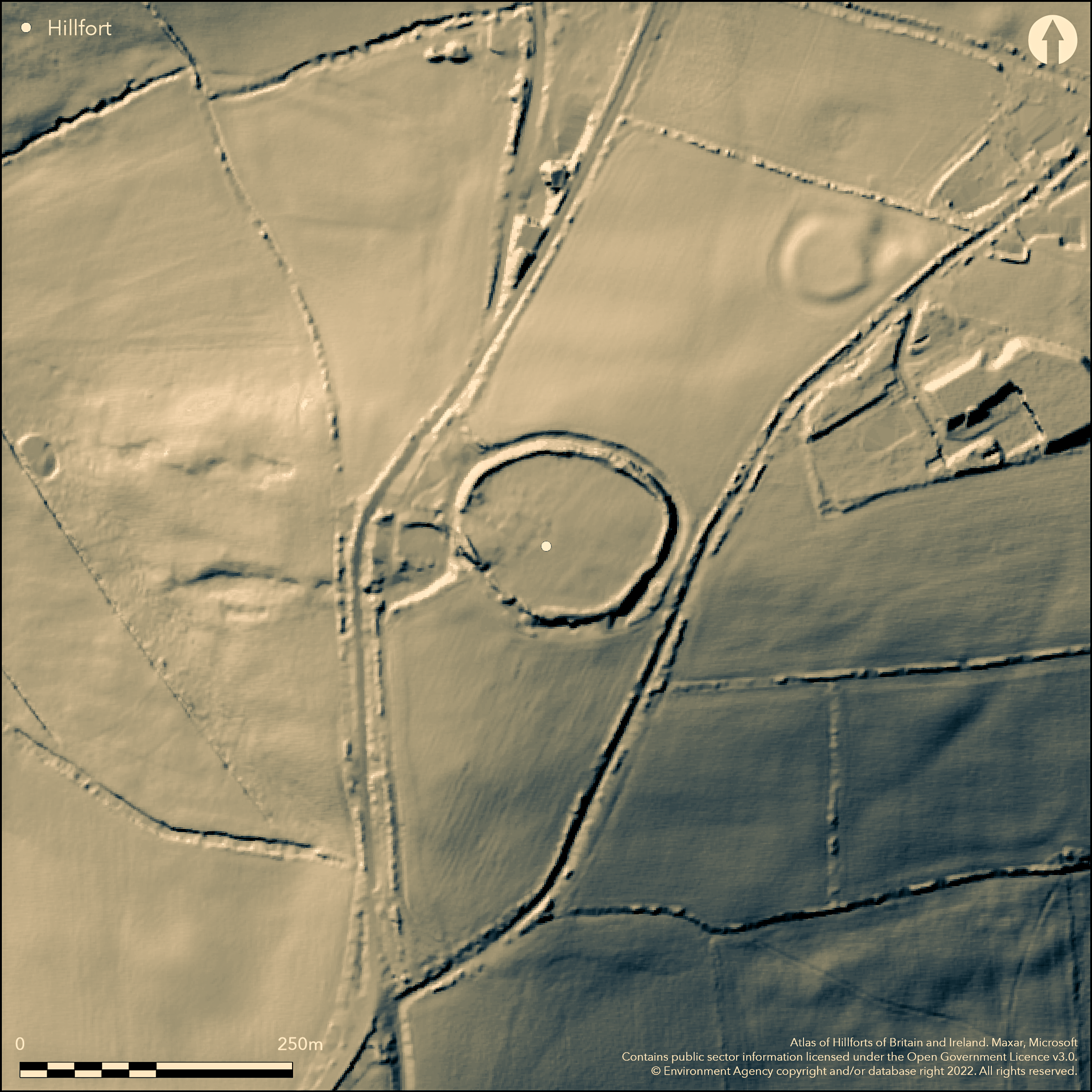
LiDAR 1m DTM Hillshade
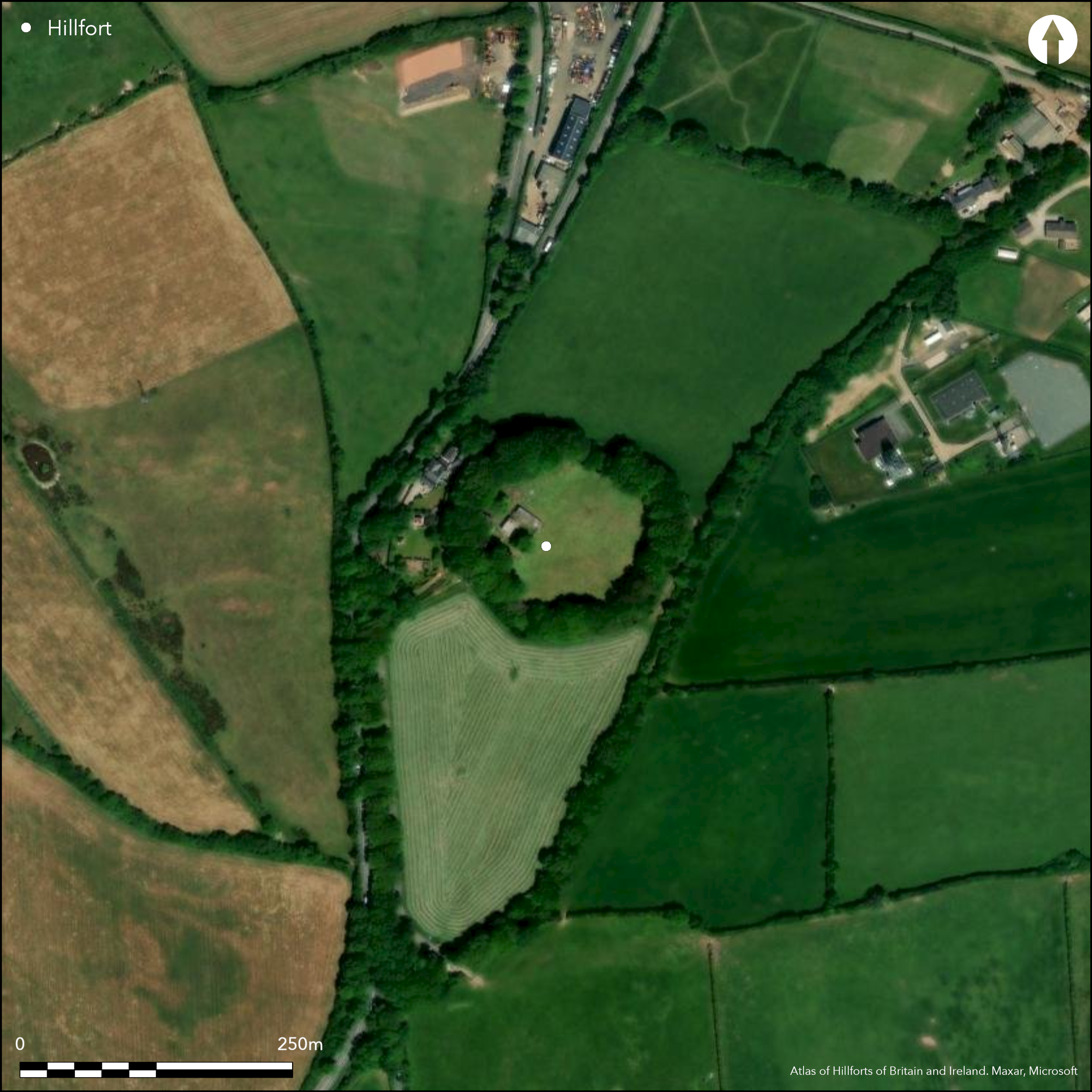
Satellite Imagery
LiDAR 1m DTM Hillshade
Satellite Imagery
Scroll left/right to view further images.
HER: Devon MDV7622 (None)
NMR: SX 75 SE 5 (444660)
SM: 1019314
NGR: SX77255165
X: 277261 Y: 51662 (OSGB36)
Hillslope fort located on SSW-facing slope of level hilltop. River Dart estuary to E. Commanding views to S and W. Moderate to strong slopes to N, steep slopes to S and W, moderate along ridge on E. Mature beech trees on surrounding banks make site prominent landmark. Roughly sub-circular in plan, measuring c. 145m E-W by 130m, enclosing c. 2ha. Rampart, 6m wide, around circuit 1.5m-2m from interior falling c. 3m to ditch, 12m wide on N, 8m on S, averaging 1.5m deep. Traces of counterscarp in infringing garden of house on W to 0.7m high and 7m wide. To W here ground falls steeply entrance climbs into fort and on E narrow entrance blocked with stone-faced bank. Both probably later entrances and original possibly on S where causeway crosses ditch. Possibly site of Anglo-Saxon burh of Healghwille. Meeting place of the hundred of Stanborough. Large bowl barrow with central stone chamber In SE of fort's centre; low mound 17m diameter to 0.1m high, with quarry ditch. Interior pasture, dense mature beech trees on banks. Despite some damage to ramparts survives well.House and garden infringe site on W. A381 skirts site on W. On 1st Ed. OS map (1886). Minimal investigations, undated.
Citizen Science: ✗
Reliability of Data: Confirmed
Reliability of Interpretation: Confirmed
X: -414850 Y: 6507456 (EPSG: 3857)
Longitude: -3.7266641362059265 Latitude: 50.35197077702247 (EPSG:4326)
Country: England; None
Current County or Unitary Authority: Devon
Historic County: Devon
Current Parish/Community/Council/Townland: Halwell; Moreleigh
Despite some damage to ramparts survives well. A381 skirts site on W. House and garden infringe site on W.
| Extant | ✓ |
| Cropmark | ✗ |
| Likely Destroyed | ✗ |
Interior pasture, dense mature beech trees on banks.
| Woodland | ✓ |
| Commercial Forestry Plantation | ✗ |
| Parkland | ✗ |
| Pasture (Grazing) | ✓ |
| Arable | ✗ |
| Scrub/Bracken | ✗ |
| Bare Outcrop | ✗ |
| Heather/Moorland | ✗ |
| Heath | ✗ |
| Built-up | ✗ |
| Coastal Grassland | ✗ |
| Other | ✗ |
Hillslope fort located on SSW-facing slope of level hilltop. River Dart estuary to E. Commanding views to S and W. Moderate to strong slopes to N, steep slopes to S and W, moderate along ridge on E.
| Contour Fort | ✗ |
| Partial Contour Fort | ✗ |
| Promontory Fort | ✗ |
| Hillslope Fort | ✓ |
| Level Terrain Fort | ✗ |
| Marsh Fort | ✗ |
| Multiple Enclosure Fort | ✗ |
| Hilltop | ✗ |
| Coastal Promontory | ✗ |
| Inland Promontory | ✗ |
| Valley Bottom | ✗ |
| Knoll/Hillock/Outcrop | ✗ |
| Ridge | ✗ |
| Cliff/Plateau-edge/Scarp | ✗ |
| Hillslope | ✓ |
| Lowland | ✗ |
| Spur | ✗ |
Dominant Topographic Feature: Hillslope
| North | ✗ |
| Northeast | ✗ |
| East | ✗ |
| Southeast | ✗ |
| South | ✗ |
| Southwest | ✓ |
| West | ✗ |
| Northwest | ✗ |
| Level | ✗ |
Altitude: 206.0m
Boundary Type: Parish/Townland
None.
Reliability: D - None
| Pre 1200BC | ✗ |
| 1200BC - 800BC | ✗ |
| 800BC - 400BC | ✗ |
| 400BC - AD50 | ✗ |
| AD50 - AD400 | ✗ |
| AD400 - AD 800 | ✗ |
| Post AD800 | ✗ |
| Unknown | ✓ |
| Pre Hillfort: | Large bowl barrow with central stone chamber In SE of fort's centre |
| Post Hillfort: | Possibly site of Anglo-Saxon burh of Healghwille. Meeting place of the hundred of Stanborough. |
Possible site for a fort of the Burghal Hidage c. 918 AD. Possibly site of Anglo-Saxon burh of Healghwille. Meeting place of the hundred of Stanborough. On 1st Ed. OS map (1886). Watching Brief South West Archaeology 2010.
| 1st Identified Map Depiction (1886): | OS map. |
| Other (2010): | Watching Brief South West Archaeology. |
| 1st Identified Written Reference (None): | Possible site for a fort of the Burghal Hidage. |
Large bowl barrow with central stone chamber In SE of fort's centre; low mound 17m diameter to 0.1m high, with quarry ditch. Chance finds of pottery and coins - no details.
None
| None | ✓ |
| Spring | ✗ |
| Stream | ✗ |
| Pool | ✗ |
| Flush | ✗ |
| Well | ✗ |
| Other | ✗ |
None
| No Known Features | ✓ |
| Round Stone Structures | ✗ |
| Rectangular Stone Structures | ✗ |
| Curvilinear Platforms | ✗ |
| Other Roundhouse Evidence | ✗ |
| Pits | ✗ |
| Quarry Hollows | ✗ |
| Other | ✗ |
None
| No Known Excavation | ✓ |
| Pits | ✗ |
| Postholes | ✗ |
| Roundhouses | ✗ |
| Rectangular Structures | ✗ |
| Roads/Tracks | ✗ |
| Quarry Hollows | ✗ |
| Other | ✗ |
| Nothing Found | ✗ |
None
| No Known Geophysics | ✓ |
| Pits | ✗ |
| Roundhouses | ✗ |
| Rectangular Structures | ✗ |
| Roads/Tracks | ✗ |
| Quarry Hollows | ✗ |
| Other | ✗ |
| Nothing Found | ✗ |
Chance finds of pottery and coins - no details.
| No Known Finds | ✗ |
| Pottery | ✓ |
| Metal | ✗ |
| Metalworking | ✗ |
| Human Bones | ✗ |
| Animal Bones | ✗ |
| Lithics | ✗ |
| Environmental | ✗ |
| Other | ✓ |
None
| APs Not Checked | ✓ |
| None | ✗ |
| Roundhouses | ✗ |
| Rectangular Structures | ✗ |
| Pits | ✗ |
| Postholes | ✗ |
| Roads/Tracks | ✗ |
| Other | ✗ |
To W here ground falls steeply entrance climbs into fort and on E narrow entrance blocked with stone- faced bank. Both probably later entrances and original possibly on S where causeway crosses ditch.
| 3: | E and W entrances possibly later. |
| 2: | None |
Guard Chambers: ✗
Chevaux de Frise: ✗
| 1. Simple Gap (South): | Causeway across ditch. |
Rampart, 6m wide, around circuit 1.5m-2m from interior falling c. 3m to ditch, 12m wide on N, 8 on S, averaging 1.5m deep. Traces of counterscarp in infringing garden of house on W to 0.7m high and 7m wide. Rebuilding in evidence.
| Area 1: | 2.0ha. |
| Total: | 2.0ha. |
Total Footprint Area: Noneha.
None
| ✗ | None |
| ✓ | None |
| NE Quadrant: | 1 |
| SE Quadrant: | 1 |
| SW Quadrant: | 1 |
| NW Quadrant: | 1 |
| Total: | 1 |
| Partial Univallate | ✗ |
| Univallate | ✓ |
| Partial Bivallate | ✗ |
| Bivallate | ✗ |
| Partial Multivallate | ✗ |
| Multivallate | ✗ |
| Unknown | ✗ |
| Partial Univallate | ✗ |
| Univallate | ✗ |
| Partial Bivallate | ✗ |
| Bivallate | ✗ |
| Partial Multivallate | ✗ |
| Multivallate | ✗ |
Counterscarp traces in garden on W.
| None | ✗ |
| Earthen Bank | ✓ |
| Stone Wall | ✗ |
| Rubble | ✗ |
| Wall-walk | ✗ |
| Evidence of Timber | ✗ |
| Vitrification | ✗ |
| Other Burning | ✗ |
| Palisade | ✗ |
| Counter Scarp Bank | ✓ |
| Berm | ✗ |
| Unfinished | ✗ |
| Other | ✗ |
None
| None | ✗ |
| Earthen Bank | ✗ |
| Stone Wall | ✗ |
| Murus Duplex | ✗ |
| Timber-framed | ✗ |
| Timber-laced | ✗ |
| Vitrification | ✗ |
| Other Burning | ✗ |
| Palisade | ✗ |
| Counter Scarp Bank | ✗ |
| Berm | ✗ |
| Unfinished | ✗ |
| No Known Excavation | ✓ |
| Other | ✗ |
| ✗ | None |
| ✓ | None |
Number of Ditches: 1
| ✗ | None |
Morris, B. and Walls, S. 2010. Stanborough Farm, Halwell, Devon: results of a desk-based assessment and archaeological monitoring and recording, Report No 101202,South West Archaeology evaluation and assessment report.
Slater, T. 1991. Controlling the South Hams: The Anglo Saxon Burh at Halwell, Trans. Devonshire Assoc, 123, 57-58.
Wall, J.C. 1906. Ancient Earthworks, In W. Page (ed), The Victoria County History of the County of Devon, Vol I, London: James Street, Haymarket, 605-07.
Atlas of Hillforts:
Wikidata:
This work is licensed under CC BY-SA 4.0

 and should be cited as:
Lock, Gary and Ralston, Ian. 2024. Atlas of Hillforts of Britain and Ireland. Available at: https://hillforts.arch.ox.ac.uk
Document Version 1.1