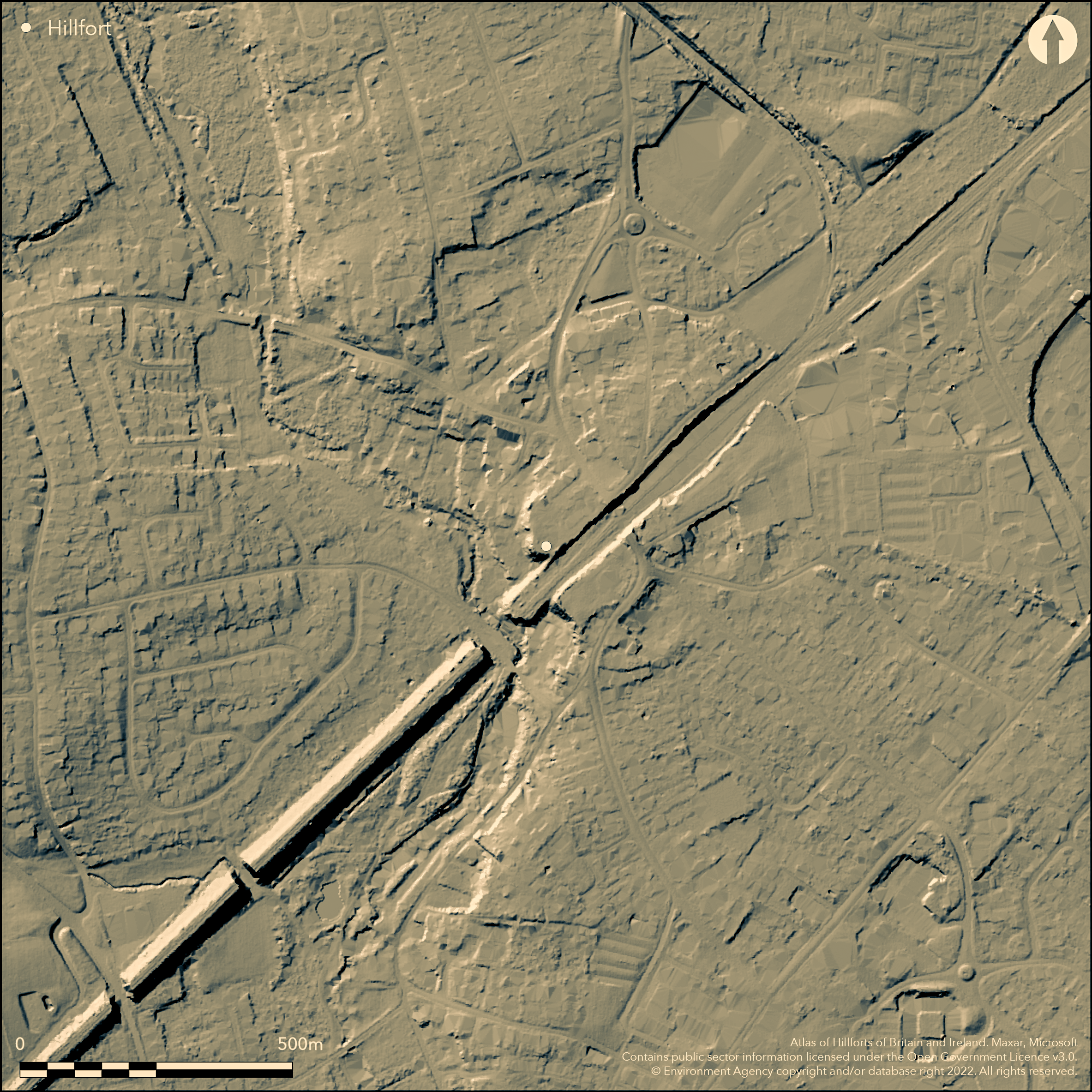
LiDAR 1m DTM Hillshade
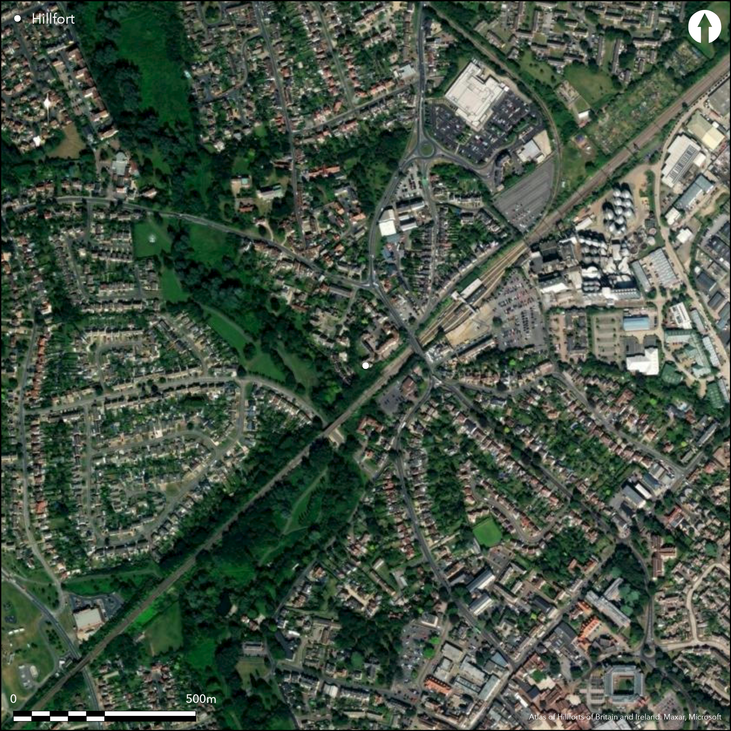
Satellite Imagery
LiDAR 1m DTM Hillshade
Satellite Imagery
Scroll left/right to view further images.
HER: Essex 8106-8110 (None)
NMR: TL 81 NW 14 (381097)
SM: None
NGR: TL 8190 1510
X: 581900 Y: 215100 (OSGB36)
Surrounding Witham railway station, two concentric earthworks variously interpreted as an Iron Age enclosed settlement, hillfort or minor oppidum, or the 10th century AD burh of Edward the Elder. Now considered to be a bivallate hillfort of two phases (Flook 1989) with the inner earthwork the univallate phase, and the second phase a 'fecamp-style' dump rampart, enclosing 3.0ha and 10.75ha respectively (Cunliffe and Rowley 1975, 331). Traces of burning was observed during excavations in 1988 (ibid.), suggesting a timber revetting in the earlier phase. It encompasses a small spur above the valley of the River Brain to the E, which today is mostly occupied by housing and other development. A railway line aligned NE-SW divides the site. In the SW a well-defined rampart stands up to 8m high with a scarp, elsewhere the ramparts survive as scarps and depressions which form an irregular oval. Excavations between 1933-35 (Cottrill 1934) recovered pottery, later determined to be Iron Age (Rodwell 1993) from the inner ditch and a probable Iron Age hut behind the inner rampart from which coins, pottery and iron and bronze objects were recovered. Excavations in 1969 and 1971 (Wilson and Hurst, 1969; Davison 1972) showed the outer ditch was V-shaped, 10m wide and 3.6m deep and the inner ditch of similar proportions. The inner ditch was considered by Cottrill to belong to an Iron Age phase and the outer ditch to the Saxon Burh, although Rodwell (1993) supports the possibility that both are of Iron Age date but of different periods. Recutting of the ditches in the NNW was identified during excavations in 1969 and 1971 (Davison 1972). Three undated inhumations were discovered c.1844 (Repton 1844) with possible grave goods described as weapons or iron pokers (Chelmsford Museum accession number N.22208). Whimster (1981) suggests they are possibly currency bars. Trial trenching ahead of development in the E revealed a 20m length of ditch 6m wide and over 2m deep lying NE-SW, which followed the proposed alignment of the outer ditch of the hillfort (Ennis 2005). Rodwell (1993, 8-33) considers the site to have been constructed in the late Bronze Age and reused in the middle Iron Age, as evidenced by the recutting of the ditch then and at intervals up to the medieval period. A watching brief in 2014 for a railway car park located within the SE of the interior, observed a NE-SW aligned ditch approximately 5m wide and over 2.5m deep on the orientation of the inner ditch. A single sherd of late Iron Age pottery was recovered (Newman 2014). Recorded on 1874-76 1:2,500 OS mapping.
Citizen Science: ✗
Reliability of Data: Confirmed
Reliability of Interpretation: Unconfirmed
X: 70908 Y: 6764925 (EPSG: 3857)
Longitude: 0.6369744444095587 Latitude: 51.80489647078502 (EPSG:4326)
Country: England
Current County or Unitary Authority: Essex
Historic County: Essex
Current Parish/Community/Council/Townland: Witham
Mostly destroyed since the 1830s by the London-Colchester railway, quarrying, housing and commercial development
| Extant | ✓ |
| Cropmark | ✗ |
| Likely Destroyed | ✓ |
None
| Woodland | ✗ |
| Commercial Forestry Plantation | ✗ |
| Parkland | ✗ |
| Pasture (Grazing) | ✗ |
| Arable | ✗ |
| Scrub/Bracken | ✗ |
| Bare Outcrop | ✗ |
| Heather/Moorland | ✗ |
| Heath | ✗ |
| Built-up | ✓ |
| Coastal Grassland | ✗ |
| Other | ✗ |
Hillslope fort overlooking the valley of the R. Brain
| Contour Fort | ✗ |
| Partial Contour Fort | ✗ |
| Promontory Fort | ✗ |
| Hillslope Fort | ✓ |
| Level Terrain Fort | ✗ |
| Marsh Fort | ✗ |
| Multiple Enclosure Fort | ✗ |
| Hilltop | ✗ |
| Coastal Promontory | ✗ |
| Inland Promontory | ✗ |
| Valley Bottom | ✗ |
| Knoll/Hillock/Outcrop | ✗ |
| Ridge | ✗ |
| Cliff/Plateau-edge/Scarp | ✗ |
| Hillslope | ✓ |
| Lowland | ✗ |
| Spur | ✗ |
Dominant Topographic Feature: Overlooking valley of the River Brain
| North | ✗ |
| Northeast | ✗ |
| East | ✗ |
| Southeast | ✗ |
| South | ✗ |
| Southwest | ✗ |
| West | ✓ |
| Northwest | ✗ |
| Level | ✗ |
Altitude: 22.0m
N/A
Iron Age pottery and artefacts from excavation. A small number of Romano-British pottery sherds recovered during excavations. Earthworks strengthened in the Saxon period. Evidence for recutting of the ditches in the early 13th century and possibly reused as a fortified manor
Reliability: B - Medium
| Pre 1200BC | ✗ |
| 1200BC - 800BC | ✗ |
| 800BC - 400BC | ✓ |
| 400BC - AD50 | ✓ |
| AD50 - AD400 | ✗ |
| AD400 - AD 800 | ✗ |
| Post AD800 | ✗ |
| Unknown | ✗ |
| Pre Hillfort: | None |
| Post Hillfort: | None |
| Artefactual: | None |
General reference in (Wright 1836). Recorded on 1874-76 1:2,500 OS mapping. Planned by RCHM in 1921. Excavations in 1933-35, 1969 and 1971, 1988, 2005, 2010. Watching Briefs in 2005, 2014, 2014.
| 1st Identified Written Reference (1836): | (Wright 1836) |
| Earthwork Survey (1921): | RCHME |
| Excavation (1988): | (Flook 1989) |
| Excavation (2005): | (Ennis 2005) |
| Other (2005): | Watching briefs (Ennis 2005; Orr 2005) |
| Excavation (2010): | (Wightman 2010) |
| Other (2014): | Watching brief (Newman 2014) |
| 1st Identified Map Depiction (None): | None |
| Excavation (None): | Cotteril 1934 and Report of the Congress of Archaeological Societies /1935/24) |
| Excavation (None): | (Wilson and Hurst; 1969 Davison 1972) |
The site is now occupied by modern housing and infrastructure. Three inhumation burials were discovered c. 1844 and a possible hut site between 1933-5
The River Brain lies to the W
| None | ✓ |
| Spring | ✗ |
| Stream | ✗ |
| Pool | ✗ |
| Flush | ✗ |
| Well | ✗ |
| Other | ✗ |
None
| No Known Features | ✓ |
| Round Stone Structures | ✗ |
| Rectangular Stone Structures | ✗ |
| Curvilinear Platforms | ✗ |
| Other Roundhouse Evidence | ✗ |
| Pits | ✗ |
| Quarry Hollows | ✗ |
| Other | ✗ |
None
| No Known Excavation | ✗ |
| Pits | ✗ |
| Postholes | ✗ |
| Roundhouses | ✓ |
| Rectangular Structures | ✗ |
| Roads/Tracks | ✗ |
| Quarry Hollows | ✗ |
| Other | ✗ |
| Nothing Found | ✗ |
None
| No Known Geophysics | ✓ |
| Pits | ✗ |
| Roundhouses | ✗ |
| Rectangular Structures | ✗ |
| Roads/Tracks | ✗ |
| Quarry Hollows | ✗ |
| Other | ✗ |
| Nothing Found | ✗ |
Pottery, coins, bronze and iron objects, bone point, bone comb, triangular loom weight and animal bone ('ox' and sheep). Human remains were also found
| No Known Finds | ✗ |
| Pottery | ✓ |
| Metal | ✓ |
| Metalworking | ✗ |
| Human Bones | ✓ |
| Animal Bones | ✓ |
| Lithics | ✗ |
| Environmental | ✗ |
| Other | ✓ |
Built up
| APs Not Checked | ✓ |
| None | ✗ |
| Roundhouses | ✗ |
| Rectangular Structures | ✗ |
| Pits | ✗ |
| Postholes | ✗ |
| Roads/Tracks | ✗ |
| Other | ✗ |
The site is mostly destroyed and the location of entrances could not be determined.
| None: | None |
| 2: | None |
Guard Chambers: ✗
Chevaux de Frise: ✗
Two concentric earthwork defences considered to be a possible bivallate hillfort. A railway cutting aligned NE-SW divides the site which is represented by scarps and depressions forming an irregular oval and in the SW by a well-defined rampart up to 8m high and a scarp. Excavations showed the outer ditch was V-shaped, 10m wide and 3.6m deep and the inner ditch of similar proportions. The inner ditch was considered by Cottrill to belong to an Iron Age phase and the outer ditch to the Saxon Burh, although Rodwell (1993) raises the possibility that both are of Iron Age date but of different periods. Recutting of the ditches in the NNW was identified during excavations in 1969
| Area 1: | 3.0ha. |
| Area 2: | 10.75ha. |
| Total: | 10.75ha. |
Total Footprint Area: Noneha.
None
| ✓ | None |
| ✗ | Mostly destroyed, possibly bivallate in final phase |
| NE Quadrant: | None |
| SE Quadrant: | None |
| SW Quadrant: | None |
| NW Quadrant: | None |
| Total: | None |
| Partial Univallate | ✗ |
| Univallate | ✗ |
| Partial Bivallate | ✗ |
| Bivallate | ✗ |
| Partial Multivallate | ✗ |
| Multivallate | ✗ |
| Unknown | ✓ |
| Partial Univallate | ✗ |
| Univallate | ✓ |
| Partial Bivallate | ✗ |
| Bivallate | ✓ |
| Partial Multivallate | ✗ |
| Multivallate | ✗ |
None
| None | ✓ |
| Earthen Bank | ✗ |
| Stone Wall | ✗ |
| Rubble | ✗ |
| Wall-walk | ✗ |
| Evidence of Timber | ✗ |
| Vitrification | ✗ |
| Other Burning | ✗ |
| Palisade | ✗ |
| Counter Scarp Bank | ✗ |
| Berm | ✗ |
| Unfinished | ✗ |
| Other | ✗ |
None
| None | ✗ |
| Earthen Bank | ✓ |
| Stone Wall | ✗ |
| Murus Duplex | ✗ |
| Timber-framed | ✓ |
| Timber-laced | ✗ |
| Vitrification | ✗ |
| Other Burning | ✓ |
| Palisade | ✗ |
| Counter Scarp Bank | ✗ |
| Berm | ✗ |
| Unfinished | ✗ |
| No Known Excavation | ✗ |
| Other | ✗ |
| ✗ | None |
| ✓ | None |
Number of Ditches: 2
| ✗ | None |
Cotterill, F. 1934. A trial excavation at Witham, Essex. Antiq J 14, 190-91
Cunliffe, B. and Rowley, T. (eds) 1976. Oppida: the beginnings of urbanisation in Barbarian Europe, BAR Int Ser 11.
Davison, B.K. 1972. Notes and News. The Burghal Hidage fort of Eorpeburnan: a suggested identification Medieval Archaeol, 16, 123-7
Ennis, T. 2005. 32a Avenue Road, Witham, Essex. Archaeological Evaluation and Monitoring. Essex County Council Field Archaeology Unit. Unpublished. https://archaeologydataservice.ac.uk/archiveDS/archiveDownload?t=arch-439-1/dissemination/pdf/essexcou1-8245.pdf. Accessed November 2015
Flook, R.1989 Excavations in Essex 1988. Witham, Chipping Hill (TL819151) Essex Archaeol Hist, Vol 20, 170
Newman, J. 2014. Eckard House, Easton Road, Witham, Essex- Archaeological Monitoring Report. John Newman Archaeological Services [assessment & evaluation reports]
Orr, K. 2005. An archaeological watching brief at 37 Avenue Road, Witham, Essex. Colchester Archaeological Trust [assessment & evaluation reports]
Repton, J. A. 1844. Proceedings of the Central Committee of the British Archaeological Association Arch J . 1, 393
Rodwell, W. 1993. The Origins and Early Development of Witham, Essex: a study in settlement and fortification, prehistoric to medieval. Oxbow Monograph 26
Whimster, R. 1981. Burial Practices in Iron Age Britain. Oxford BAR British Series 90
Wilson D.M. and Hurst D.G. 1969. Medieval Britain in 1969. Medieval Archaeol, 14, 156
Wright, T. 1836. The History and Topography of the County of Essex, Vol. I (London)
Atlas of Hillforts:
Wikidata:
This work is licensed under CC BY-SA 4.0

 and should be cited as:
Lock, Gary and Ralston, Ian. 2024. Atlas of Hillforts of Britain and Ireland. Available at: https://hillforts.arch.ox.ac.uk
Document Version 1.1