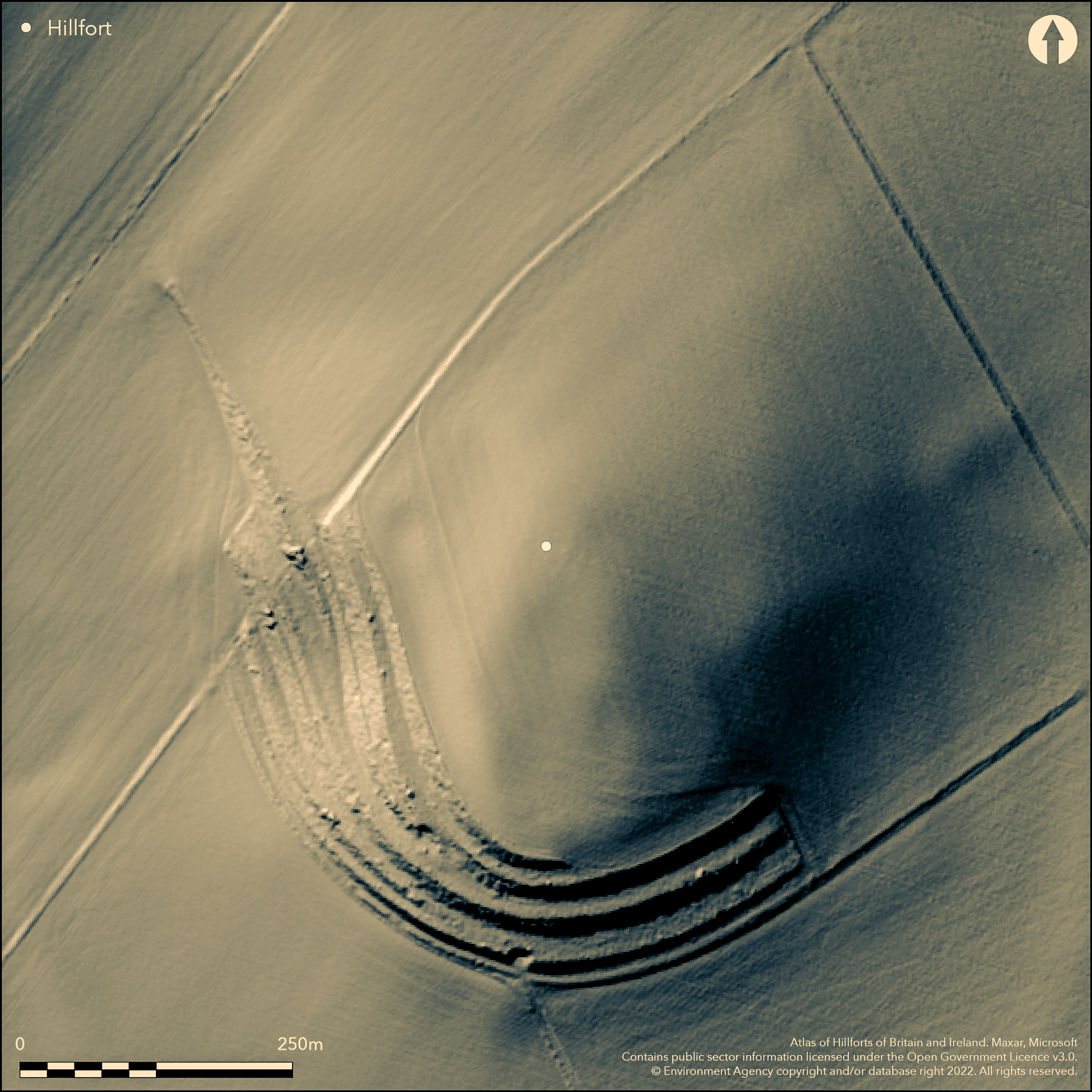
LiDAR 1m DTM Hillshade
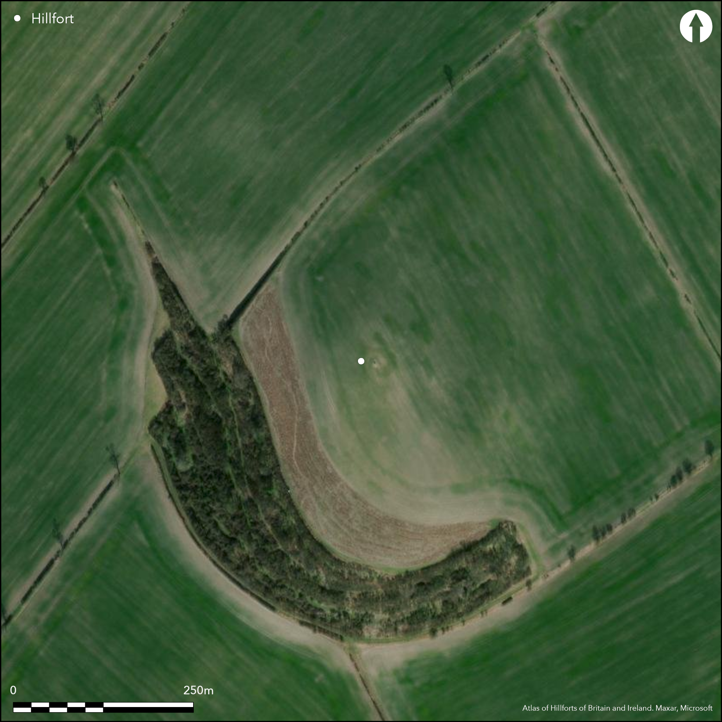
Satellite Imagery
LiDAR 1m DTM Hillshade
Satellite Imagery
Scroll left/right to view further images.
HER: Buckinghamshire 154400000 (None)
NMR: SP 91 NW 40 (1160034)
SM: 1017517
NGR: SP 9193 1660
X: 491933 Y: 216607 (OSGB36)
Lying approximately 500m to the S of Cheddington on Southend Hill, the cropmarked remains of a bivallate hillfort recorded on aerial photographs taken in 1973 and 1977. The cropmarked ditches form two concentric arcs 5m wide set 15-20m apart. They encircle a prominent chalk knoll at 140m OD enclosing 5ha. The remainder of the enclosing works in the S and SW lie within woodland and scrub on Southend Hill. A spread of chalk and chalky limestone boulders, possibly deriving from the ramparts, have been recorded across the field in the NW and SE. The location of the entrance is not recorded. Within the interior, small circular cropmarks, probably structures, have been identified and a curving ditch seen on aerial photographs taken in 2010 is possibly the remains of an earlier phase of enclosure. A series of cultivation terraces later formed on the slopes in the S and SW, possibly incorporating the hillfort bank. Fragments of coarseware pottery, 600-300 BC, and late Iron Age wheel-thrown vessels recovered from the surface of the field suggest later or continued occupation. The site is intervisible with Ivinghoe Beacon (Atlas No. 3316) 5km to the E and suggested by Farley (1983, 179) that one might have replaced the other. Only the cultivation terraces are recorded on OS mapping. Scheduled as a small multivallate (sic.) hillfort.
Citizen Science: ✗
Reliability of Data: Confirmed
Reliability of Interpretation: Confirmed
X: -74250 Y: 6771331 (EPSG: 3857)
Longitude: -0.6669967565508117 Latitude: 51.84046466394526 (EPSG:4326)
Country: England
Current County or Unitary Authority: Buckinghamshire
Historic County: Buckinghamshire
Current Parish/Community/Council/Townland: Cheddington
On Heritage at Risk Register (2015).
| Extant | ✗ |
| Cropmark | ✓ |
| Likely Destroyed | ✗ |
Woodland and scrub in the S
| Woodland | ✓ |
| Commercial Forestry Plantation | ✗ |
| Parkland | ✗ |
| Pasture (Grazing) | ✗ |
| Arable | ✓ |
| Scrub/Bracken | ✓ |
| Bare Outcrop | ✗ |
| Heather/Moorland | ✗ |
| Heath | ✗ |
| Built-up | ✗ |
| Coastal Grassland | ✗ |
| Other | ✗ |
A former contour fort occupying the summit of a prominent knoll at 140m OD. The ground slopes away in all directions, especially in the S
| Contour Fort | ✓ |
| Partial Contour Fort | ✗ |
| Promontory Fort | ✗ |
| Hillslope Fort | ✗ |
| Level Terrain Fort | ✗ |
| Marsh Fort | ✗ |
| Multiple Enclosure Fort | ✗ |
| Hilltop | ✓ |
| Coastal Promontory | ✗ |
| Inland Promontory | ✗ |
| Valley Bottom | ✗ |
| Knoll/Hillock/Outcrop | ✓ |
| Ridge | ✗ |
| Cliff/Plateau-edge/Scarp | ✗ |
| Hillslope | ✗ |
| Lowland | ✗ |
| Spur | ✗ |
Dominant Topographic Feature: Prominent knoll
| North | ✗ |
| Northeast | ✗ |
| East | ✗ |
| Southeast | ✗ |
| South | ✓ |
| Southwest | ✗ |
| West | ✗ |
| Northwest | ✗ |
| Level | ✗ |
Altitude: 140.0m
N/A
Dated from surface finds of Iron Age coarsewares and some wheelthrown vessels. Traces of one or more internal ditches possibly represent a different phase of enclosure (Farley 1983)
Reliability: B - Medium
| Pre 1200BC | ✗ |
| 1200BC - 800BC | ✗ |
| 800BC - 400BC | ✓ |
| 400BC - AD50 | ✓ |
| AD50 - AD400 | ✗ |
| AD400 - AD 800 | ✗ |
| Post AD800 | ✗ |
| Unknown | ✗ |
| Pre Hillfort: | None |
| Post Hillfort: | None |
| Artefactual: | None |
Discovered from aerial photographs in 1973 and scheduled in 1997. No further investigation has taken place
| Other (1973): | Recorded on aerial photograph |
| 1st Identified Written Reference (1983): | (Farley 1983) |
| Other (1997): | Scheduled |
Small circular cropmarks, have been recorded on aerial photographs. Surface pottery.
None
| None | ✓ |
| Spring | ✗ |
| Stream | ✗ |
| Pool | ✗ |
| Flush | ✗ |
| Well | ✗ |
| Other | ✗ |
None
| No Known Features | ✓ |
| Round Stone Structures | ✗ |
| Rectangular Stone Structures | ✗ |
| Curvilinear Platforms | ✗ |
| Other Roundhouse Evidence | ✗ |
| Pits | ✗ |
| Quarry Hollows | ✗ |
| Other | ✗ |
None
| No Known Excavation | ✓ |
| Pits | ✗ |
| Postholes | ✗ |
| Roundhouses | ✗ |
| Rectangular Structures | ✗ |
| Roads/Tracks | ✗ |
| Quarry Hollows | ✗ |
| Other | ✗ |
| Nothing Found | ✗ |
None
| No Known Geophysics | ✓ |
| Pits | ✗ |
| Roundhouses | ✗ |
| Rectangular Structures | ✗ |
| Roads/Tracks | ✗ |
| Quarry Hollows | ✗ |
| Other | ✗ |
| Nothing Found | ✗ |
None
| No Known Finds | ✗ |
| Pottery | ✓ |
| Metal | ✗ |
| Metalworking | ✗ |
| Human Bones | ✗ |
| Animal Bones | ✗ |
| Lithics | ✗ |
| Environmental | ✗ |
| Other | ✗ |
Small circular cropmarks
| APs Not Checked | ✗ |
| None | ✗ |
| Roundhouses | ✗ |
| Rectangular Structures | ✗ |
| Pits | ✗ |
| Postholes | ✗ |
| Roads/Tracks | ✗ |
| Other | ✓ |
No entrance has been recorded
| 0: | None |
| 2: | None |
Guard Chambers: ✗
Chevaux de Frise: ✗
Cropmarked ditches form two concentric arcs 5m wide and set 15-20m apart. The remainder of the enclosing works in the S and SW lies under woodland and scrub which appears to follow the line of the former ramparts
| Area 1: | 5.0ha. |
| Total: | 5.0ha. |
Total Footprint Area: Noneha.
None
| ✓ | Curving ditch seen on aerial photographs taken in 2010 is possibly the remains of an earlier phase of enclosure |
| ✓ | Ramparts plough-levelled |
| NE Quadrant: | 2 |
| SE Quadrant: | 2 |
| SW Quadrant: | 2 |
| NW Quadrant: | 2 |
| Total: | 2 |
| Partial Univallate | ✗ |
| Univallate | ✗ |
| Partial Bivallate | ✗ |
| Bivallate | ✓ |
| Partial Multivallate | ✗ |
| Multivallate | ✗ |
| Unknown | ✗ |
| Partial Univallate | ✗ |
| Univallate | ✗ |
| Partial Bivallate | ✗ |
| Bivallate | ✗ |
| Partial Multivallate | ✗ |
| Multivallate | ✗ |
None
| None | ✓ |
| Earthen Bank | ✗ |
| Stone Wall | ✗ |
| Rubble | ✗ |
| Wall-walk | ✗ |
| Evidence of Timber | ✗ |
| Vitrification | ✗ |
| Other Burning | ✗ |
| Palisade | ✗ |
| Counter Scarp Bank | ✗ |
| Berm | ✗ |
| Unfinished | ✗ |
| Other | ✗ |
None
| None | ✗ |
| Earthen Bank | ✗ |
| Stone Wall | ✗ |
| Murus Duplex | ✗ |
| Timber-framed | ✗ |
| Timber-laced | ✗ |
| Vitrification | ✗ |
| Other Burning | ✗ |
| Palisade | ✗ |
| Counter Scarp Bank | ✗ |
| Berm | ✗ |
| Unfinished | ✗ |
| No Known Excavation | ✓ |
| Other | ✗ |
| ✗ | None |
| ✓ | None |
Number of Ditches: 2
| ✗ | None |
Farley, M. 1983. Cheddington Hillfort. Recs Buckinghamshire. Vol. 25, 179
Atlas of Hillforts:
Wikidata:
This work is licensed under CC BY-SA 4.0

 and should be cited as:
Lock, Gary and Ralston, Ian. 2024. Atlas of Hillforts of Britain and Ireland. Available at: https://hillforts.arch.ox.ac.uk
Document Version 1.1