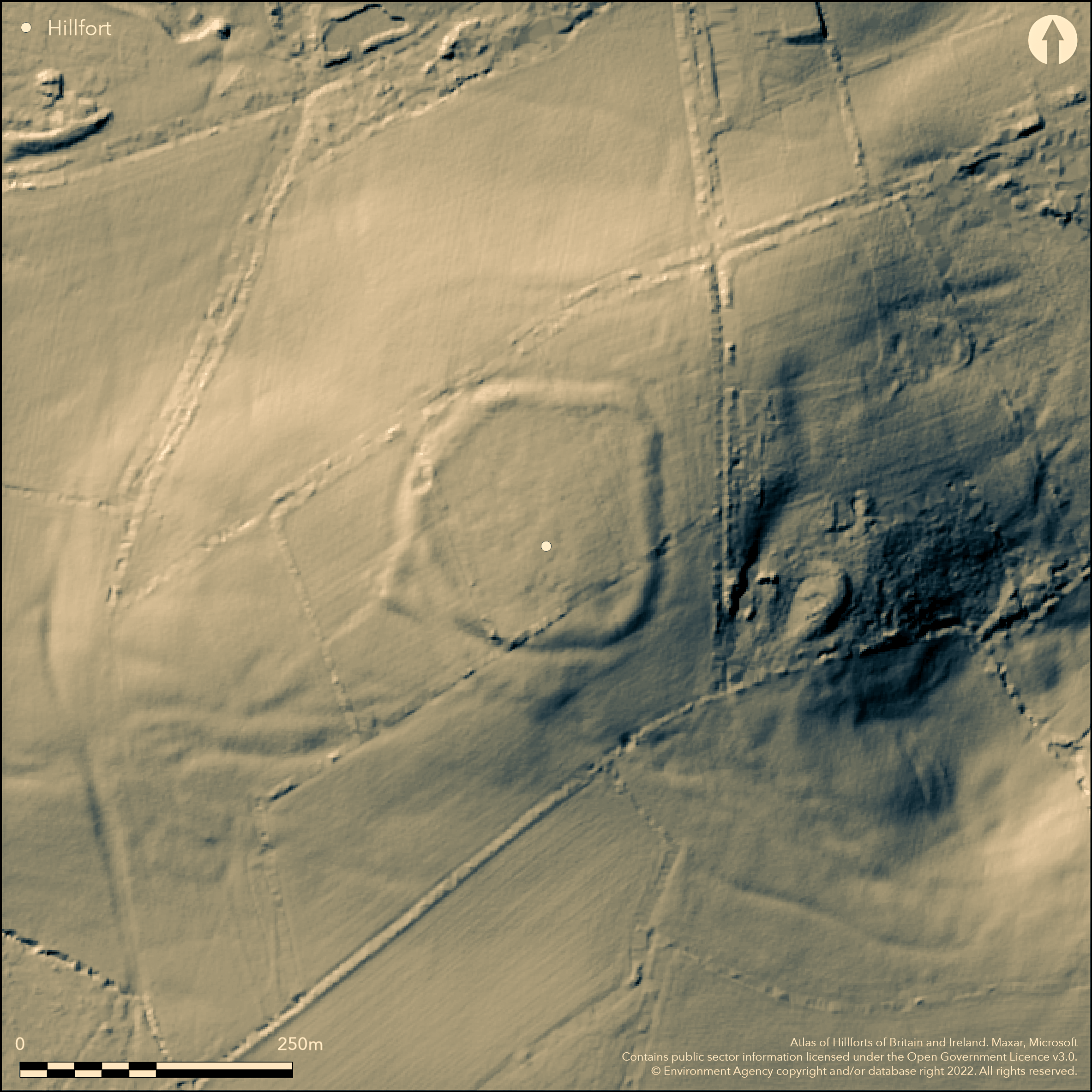
LiDAR 1m DTM Hillshade
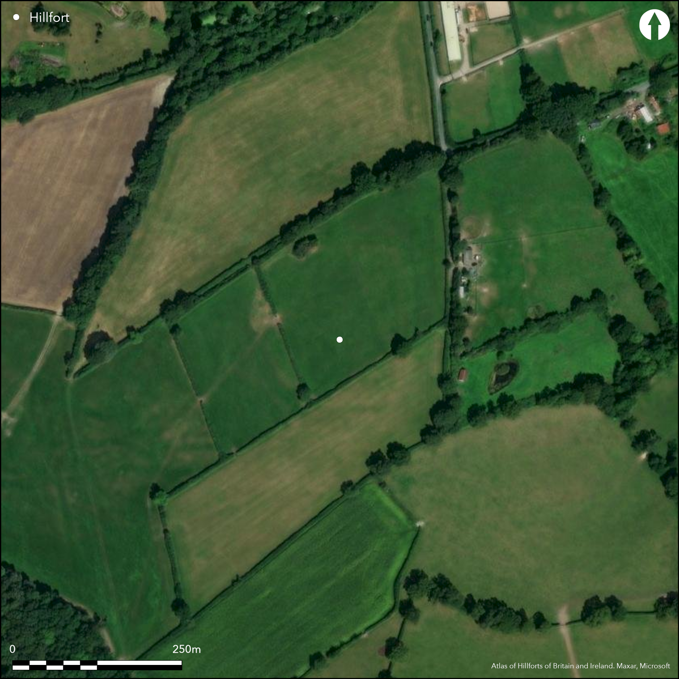
Satellite Imagery
LiDAR 1m DTM Hillshade
Satellite Imagery
Scroll left/right to view further images.
HER: Dorset MDO4526 (None)
NMR: ST 71 SE 11 (202265)
SM: 1018873
NGR: ST 789 119
X: 378995 Y: 111929 (OSGB36)
Univallate contour hillfort located on summit of low, flat-topped hill on isolated patch of Plateau Gravel within broad belt of Kimmeridge Clay and above River Stour to N and E and tributary to W and their confluence on NW. Moderate to strong surrounding slopes, less on ridge to SE. Sub-rectangular, with internal area c. 1.2ha. Much reduced and spread by ploughing, with surrounding bank now only 0.5m-1m high above interior and c. 15m wide. Outer ditch now buried feature in parts, especially on E, but to c. 1.5m deep and 8m wide in places. Small trench for water pipe across earthwork to N of entrance gap and across outer bank on W side in 1986 found rampart constructed of local limestone with occasional flint/chert fragments, 2.5m wide at base, with a thick accumulation of gravels on outer face (Pearce and Woodward 1986), suggesting bank generally plough spread. Entrance on SW protected by an external bank, c. 15m wide and 1m high, with traces of external ditch. This branches out from main rampart at NW corner of site, running SW for short length before curving back in towards the hillfort enclosure creating passage over 75m long which narrows to c. 2m at one point. Under improved pasture and ramparts much reduced by ploughing with some quarrying and split between four fields. On 1st Ed. OS map (1887).
Citizen Science: ✓
Reliability of Data: Confirmed
Reliability of Interpretation: Confirmed
X: -256050 Y: 6604751 (EPSG: 3857)
Longitude: -2.300134147895973 Latitude: 50.90638411693453 (EPSG:4326)
Country: England; None
Current County or Unitary Authority: Dorset
Historic County: Dorset
Current Parish/Community/Council/Townland: Okeford Fitzpaine; Sturminster Newton
Ramparts much reduced by ploughing with some quarrying and split between four fields.
| Extant | ✓ |
| Cropmark | ✗ |
| Likely Destroyed | ✗ |
Improved pasture fields. Quarrying.
| Woodland | ✗ |
| Commercial Forestry Plantation | ✗ |
| Parkland | ✗ |
| Pasture (Grazing) | ✓ |
| Arable | ✗ |
| Scrub/Bracken | ✗ |
| Bare Outcrop | ✗ |
| Heather/Moorland | ✗ |
| Heath | ✗ |
| Built-up | ✗ |
| Coastal Grassland | ✗ |
| Other | ✓ |
Univallate contour hillfort located on summit of low, flat-topped hill on isolated patch of Plateau Gravel within broad belt of Kimmeridge Clay and above River Stour to N and E and tributary to W and their confluence on NW. Moderate to moderate to strong surrounding slopes, less on ridge to SE.
| Contour Fort | ✓ |
| Partial Contour Fort | ✗ |
| Promontory Fort | ✗ |
| Hillslope Fort | ✗ |
| Level Terrain Fort | ✗ |
| Marsh Fort | ✗ |
| Multiple Enclosure Fort | ✗ |
| Hilltop | ✓ |
| Coastal Promontory | ✗ |
| Inland Promontory | ✗ |
| Valley Bottom | ✗ |
| Knoll/Hillock/Outcrop | ✗ |
| Ridge | ✗ |
| Cliff/Plateau-edge/Scarp | ✗ |
| Hillslope | ✗ |
| Lowland | ✗ |
| Spur | ✗ |
Dominant Topographic Feature: Hill top
| North | ✗ |
| Northeast | ✗ |
| East | ✗ |
| Southeast | ✗ |
| South | ✗ |
| Southwest | ✗ |
| West | ✗ |
| Northwest | ✗ |
| Level | ✓ |
Altitude: 110.0m
Boundary Type: Parish/Townland
None.
Reliability: D - None
| Pre 1200BC | ✗ |
| 1200BC - 800BC | ✗ |
| 800BC - 400BC | ✗ |
| 400BC - AD50 | ✗ |
| AD50 - AD400 | ✗ |
| AD400 - AD 800 | ✗ |
| Post AD800 | ✗ |
| Unknown | ✓ |
| Pre Hillfort: | None |
| Post Hillfort: | None |
On 1st Ed. OS map (1887). Watching Brief pipeline trench 1986. LiDAR survey Citizen Science information 2015.
| 1st Identified Map Depiction (1887): | OS map. |
| Other (1986): | Watching Brief for pipeline. |
| LiDAR Survey (2015): | Citizen Science information. |
None.
None
| None | ✓ |
| Spring | ✗ |
| Stream | ✗ |
| Pool | ✗ |
| Flush | ✗ |
| Well | ✗ |
| Other | ✗ |
None
| No Known Features | ✓ |
| Round Stone Structures | ✗ |
| Rectangular Stone Structures | ✗ |
| Curvilinear Platforms | ✗ |
| Other Roundhouse Evidence | ✗ |
| Pits | ✗ |
| Quarry Hollows | ✗ |
| Other | ✗ |
None
| No Known Excavation | ✗ |
| Pits | ✗ |
| Postholes | ✗ |
| Roundhouses | ✗ |
| Rectangular Structures | ✗ |
| Roads/Tracks | ✗ |
| Quarry Hollows | ✗ |
| Other | ✗ |
| Nothing Found | ✓ |
None
| No Known Geophysics | ✓ |
| Pits | ✗ |
| Roundhouses | ✗ |
| Rectangular Structures | ✗ |
| Roads/Tracks | ✗ |
| Quarry Hollows | ✗ |
| Other | ✗ |
| Nothing Found | ✗ |
None
| No Known Finds | ✓ |
| Pottery | ✗ |
| Metal | ✗ |
| Metalworking | ✗ |
| Human Bones | ✗ |
| Animal Bones | ✗ |
| Lithics | ✗ |
| Environmental | ✗ |
| Other | ✗ |
None
| APs Not Checked | ✓ |
| None | ✗ |
| Roundhouses | ✗ |
| Rectangular Structures | ✗ |
| Pits | ✗ |
| Postholes | ✗ |
| Roads/Tracks | ✗ |
| Other | ✗ |
Interesting original entrance SW protected by an external bank, c. 15m wide and 1m high, with traces of external ditch. This branches out from main rampart at NW corner of site, running SW for short length before curving back in towards the hillfort enclosure creating passage narrowing to c. 2m at one point. SE gap modern.
| 2: | Modern SE gap. |
| 2: | None |
Guard Chambers: ✗
Chevaux de Frise: ✗
| 1. Passage-way/Corridor (South west): | Passage narrowing to c. 2m at one point. |
| 1. Outworks (South west): | Protected by external bank. |
Much reduced and spread by ploughing, with surrounding bank now only 0.5m-1m high above interior and c. 15m wide. Outer ditch now buried feature in parts, especially on E, but to c. 1.5m deep and 8m wide in places. Small trench for water pipe across earthwork to N of entrance gap and across outer bank on W side in 1986 found rampart constructed of local limestone with occasional flint/chert fragments, 2.5m wide at base, with a thick accumulation of gravels on outer face, suggesting bank generally plough spread.
| Area 1: | 1.2ha. |
| Total: | 1.2ha. |
Total Footprint Area: Noneha.
None
| ✗ | None |
| ✓ | None |
| NE Quadrant: | 1 |
| SE Quadrant: | 1 |
| SW Quadrant: | 1 |
| NW Quadrant: | 1 |
| Total: | 1 |
| Partial Univallate | ✗ |
| Univallate | ✓ |
| Partial Bivallate | ✗ |
| Bivallate | ✗ |
| Partial Multivallate | ✗ |
| Multivallate | ✗ |
| Unknown | ✗ |
| Partial Univallate | ✗ |
| Univallate | ✗ |
| Partial Bivallate | ✗ |
| Bivallate | ✗ |
| Partial Multivallate | ✗ |
| Multivallate | ✗ |
None
| None | ✗ |
| Earthen Bank | ✓ |
| Stone Wall | ✗ |
| Rubble | ✓ |
| Wall-walk | ✗ |
| Evidence of Timber | ✗ |
| Vitrification | ✗ |
| Other Burning | ✗ |
| Palisade | ✗ |
| Counter Scarp Bank | ✗ |
| Berm | ✗ |
| Unfinished | ✗ |
| Other | ✗ |
Small trench for water pipe across earthwork to N of entrance gap and across outer bank on W side in 1986 found rampart constructed of local limestone with occasional flint/chert fragments, 2.5m wide at base, with a thick accumulation of gravels on outer face, suggesting bank generally plough spread.
| None | ✗ |
| Earthen Bank | ✗ |
| Stone Wall | ✗ |
| Murus Duplex | ✗ |
| Timber-framed | ✗ |
| Timber-laced | ✗ |
| Vitrification | ✗ |
| Other Burning | ✗ |
| Palisade | ✗ |
| Counter Scarp Bank | ✗ |
| Berm | ✗ |
| Unfinished | ✗ |
| No Known Excavation | ✗ |
| Other | ✓ |
| ✗ | None |
| ✓ | Outer ditch now buried feature in parts, especially on E, but to c. 1.5m deep and 8m wide in places. |
Number of Ditches: 1
| ✗ | None |
Gale, J. 2003. Prehistoric Dorset, Stroud: Tempus Publishing.
Pearce, P. and Woodward, P.J. 1986. Observations at Banbury Hill Camp, Okeford Fitzpaine, Proc Dorset Natur Hist and Archaeol Soc, 108, 175-177.
RCHME 1970. An inventory of historical monuments in the County of Dorset, Vol 3, Central Dorset, London: RCHME.
Atlas of Hillforts:
Wikidata:
This work is licensed under CC BY-SA 4.0

 and should be cited as:
Lock, Gary and Ralston, Ian. 2024. Atlas of Hillforts of Britain and Ireland. Available at: https://hillforts.arch.ox.ac.uk
Document Version 1.1