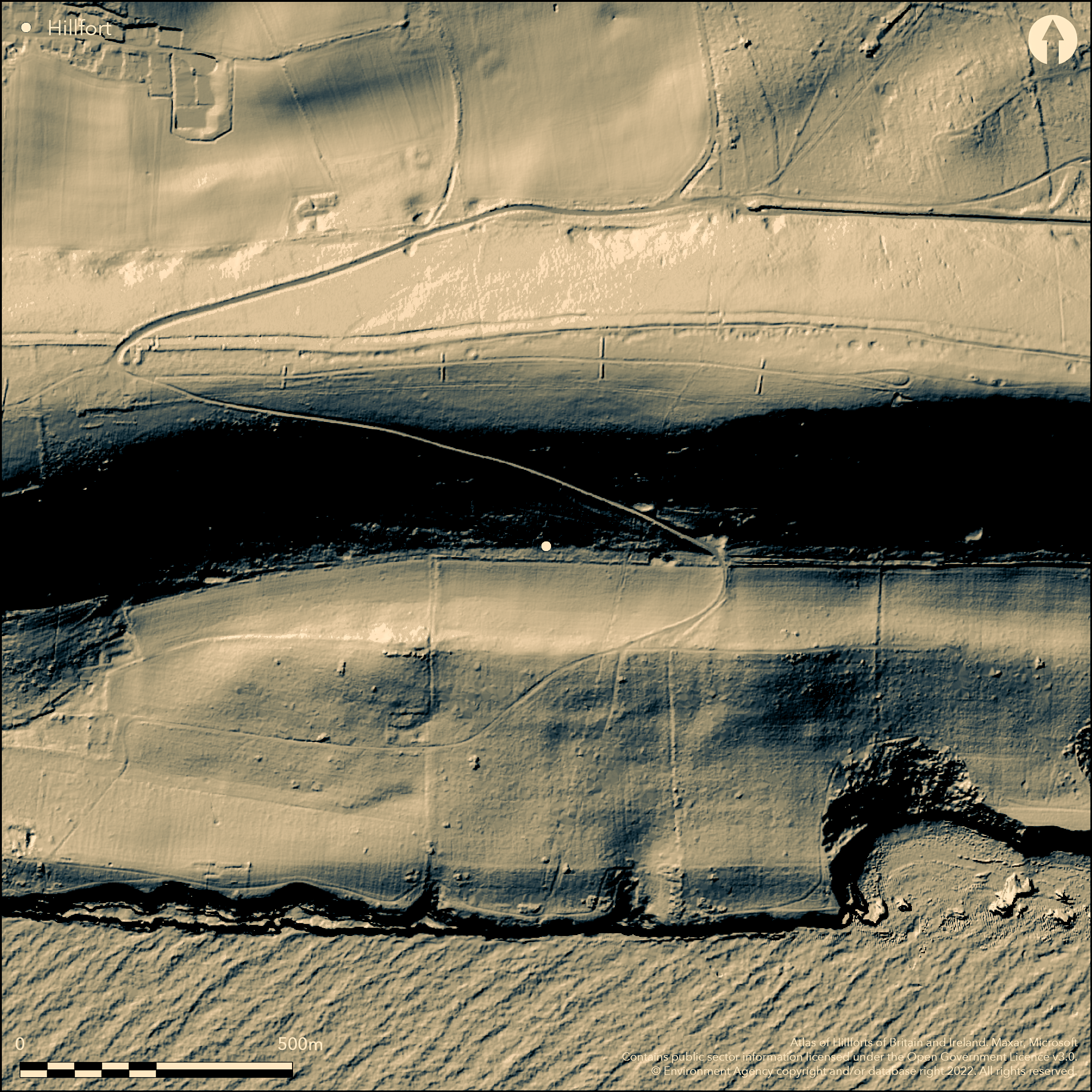
LiDAR 1m DTM Hillshade
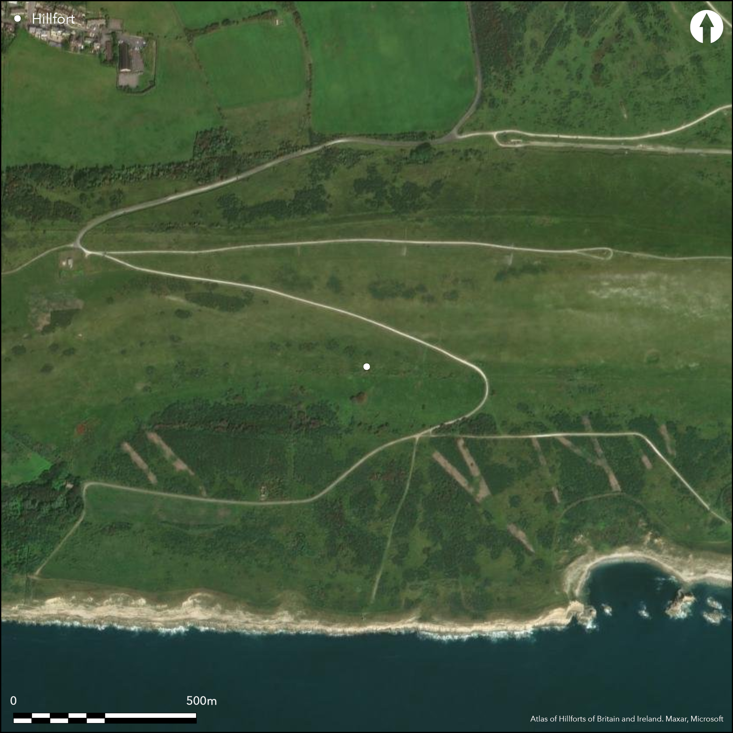
Satellite Imagery
LiDAR 1m DTM Hillshade
Satellite Imagery
Scroll left/right to view further images.
HER: Dorset MDO8257 (None)
NMR: SY 88 SW 2 (455543)
SM: 1002705
NGR: SY835802
X: 383568 Y: 80077 (OSGB36)
Bindon Hill, with earthwork nearly 2.8km long, has been called the largest hillfort in Britain. However, it is better termed an 'enclosure complex' which incorporates a possible hillfort at its W end, both showing incomplete characteristics. Bindon Hill itself is a long chalk low ridge, directly overlooking the English Channel, the earthworks extending from mid Worbarrow Bay in the E to Lulworth Cove in the W, which they swing around. The total area is open to some doubt, but the general enclosed area appears to be c. 110ha-114ha, although a figure as high as 160ha is mentioned by Gale (2003, 138). The earthworks are mostly visible on the ground, as they enclose most of the hog-backed ridge to N, which rises to c. 168m high, as well as the flat lower-lying coastal shelf topography to the S, as well as the outstanding anchorage of Lulworth Cove. The main works overall are bank and ditch facing N along the whole E-W distance. At extreme W end, probably unfinished and now disturbed banks, to around 1m high and ditch to around 1m deep, with very marked discontinuous berm, run spasmodically NNE from cliff edge above Stairhole. From here irregular earthworks run N. and then E. along the hill-top to a N-S cross-dyke. In this NW area, dumps and irregularities suggest unfinished nature of what might have been a final, smaller, univallate hillfort, possibly around 9.7ha in extent. Form of earthworks, including dumps of material at W end, suggests simultaneous gang working. Inturned entrance to enclosure about 750m from W end. Excavations across ramparts by Sir Mortimer Wheeler in 1950's revealed a great deal on the constructional sequence. Most came from section just E of entrance, showing palisade and marking out trenches. He suggested that function of site was to provide a 'beach-head' protection for Lulworth Cove, with construction c. 400 BC. More probably some form of trading post with links to continent. Any Celtic field pattern in interior obliterated by 19th century ploughing, but possible hut platforms visible. Site part of extensive MOD firing range, and, as result, access limited. Disturbed by holiday development on W. On 1st Ed. OS map (1889).
Citizen Science: ✗
Reliability of Data: Confirmed
Reliability of Interpretation: Unconfirmed
X: -248650 Y: 6554366 (EPSG: 3857)
Longitude: -2.233664490630463 Latitude: 50.62009724672261 (EPSG:4326)
Country: England; None
Current County or Unitary Authority: Dorset
Historic County: Dorset
Current Parish/Community/Council/Townland: West Lulworth; East Lulworth
Site part of extensive MOD firing range, and, as result, access limited. Disturbed by holiday development on W. On Heritage at Risk Register (2015).
| Extant | ✓ |
| Cropmark | ✗ |
| Likely Destroyed | ✗ |
Coastal grassland and MOD firing range.
| Woodland | ✗ |
| Commercial Forestry Plantation | ✗ |
| Parkland | ✗ |
| Pasture (Grazing) | ✗ |
| Arable | ✗ |
| Scrub/Bracken | ✗ |
| Bare Outcrop | ✗ |
| Heather/Moorland | ✗ |
| Heath | ✗ |
| Built-up | ✗ |
| Coastal Grassland | ✓ |
| Other | ✓ |
Bindon Hill itself is a long chalk low ridge, directly overlooking the English Channel, the earthworks extending from mid Worbarrow Bay in the E to Lulworth Cove in the W, which they swing around. The hillfort is located at W end.
| Contour Fort | ✓ |
| Partial Contour Fort | ✗ |
| Promontory Fort | ✗ |
| Hillslope Fort | ✗ |
| Level Terrain Fort | ✗ |
| Marsh Fort | ✗ |
| Multiple Enclosure Fort | ✗ |
| Hilltop | ✗ |
| Coastal Promontory | ✗ |
| Inland Promontory | ✗ |
| Valley Bottom | ✗ |
| Knoll/Hillock/Outcrop | ✗ |
| Ridge | ✓ |
| Cliff/Plateau-edge/Scarp | ✗ |
| Hillslope | ✗ |
| Lowland | ✗ |
| Spur | ✗ |
Dominant Topographic Feature: Chalk ridge.
| North | ✗ |
| Northeast | ✗ |
| East | ✗ |
| Southeast | ✗ |
| South | ✓ |
| Southwest | ✗ |
| West | ✗ |
| Northwest | ✗ |
| Level | ✗ |
Altitude: 168.0m
Boundary Type: Parish/Townland
Pottery suggests construction in mid first millennium BC.
Reliability: B - Medium
| Pre 1200BC | ✗ |
| 1200BC - 800BC | ✗ |
| 800BC - 400BC | ✗ |
| 400BC - AD50 | ✓ |
| AD50 - AD400 | ✗ |
| AD400 - AD 800 | ✗ |
| Post AD800 | ✗ |
| Unknown | ✗ |
| Pre Hillfort: | None |
| Post Hillfort: | None |
| Artefactual: | Pottery suggests construction in mid first millennium BC. |
In 13th century AD both 'dike of Julius Caesar' on Bindon Hill and the 'dike to Starhole (Stairhole)' recognised as boundaries (P.R.O., Calendar of Charter Rolls,II, 2116-7). In Aubrey's Monumenta Britannica (1665-1693). On J. Sparrow, Map of Weld Estate 1770 (in Dorset County Record Office). On 1st Ed. OS map (1889). Excavation Sir Mortimer Wheeler 1950. Watching Brief of cable trench 1977. Excavation A.H. Graham and J.W. Hawkes 1985. visits by Hillfort Study Group 1966, 2016.
| Other (1770): | On J. Sparrow, Map of Weld Estate 1770 (in Dorset County Record Office). |
| 1st Identified Map Depiction (1889): | OS map. |
| Excavation (1950): | Sir Mortimer Wheeler. |
| Other (1966): | Visit by the Hillfort Study Group |
| Other (1977): | Watching Brief of cable trench.. |
| Other (1981): | Field investigation N. Quinnell RCHME. |
| Excavation (1985): | A.H. Graham and J.W. Hawkes. |
| Other (2016): | Visit by the Hillfort Study Group |
| 1st Identified Written Reference (None): | P.R.O., Calendar of Charter Rolls, II, 2116-7). |
Spasmodic inner quarry ditches/hollows. Possible hut platforms/sites, or could be quarry hollows. Numerous mid Iron Age sherds found beneath present bank, most from coarse pots with finger-rim decoration, and few bowl fragments.
Stream runs into the Cove from the W through a sheltered valley.
| None | ✗ |
| Spring | ✗ |
| Stream | ✓ |
| Pool | ✗ |
| Flush | ✗ |
| Well | ✗ |
| Other | ✗ |
Spasmodic inner quarry ditches/hollows. Possible hut platforms/sites recorded c. 4.5m-14m diameter, or could be quarry hollows.
| No Known Features | ✗ |
| Round Stone Structures | ✗ |
| Rectangular Stone Structures | ✗ |
| Curvilinear Platforms | ✓ |
| Other Roundhouse Evidence | ✓ |
| Pits | ✗ |
| Quarry Hollows | ✓ |
| Other | ✗ |
Incomplete pattern of postholes at entrance.
| No Known Excavation | ✗ |
| Pits | ✗ |
| Postholes | ✓ |
| Roundhouses | ✗ |
| Rectangular Structures | ✗ |
| Roads/Tracks | ✗ |
| Quarry Hollows | ✗ |
| Other | ✗ |
| Nothing Found | ✗ |
None
| No Known Geophysics | ✓ |
| Pits | ✗ |
| Roundhouses | ✗ |
| Rectangular Structures | ✗ |
| Roads/Tracks | ✗ |
| Quarry Hollows | ✗ |
| Other | ✗ |
| Nothing Found | ✗ |
Numerous mid Iron Age sherds found beneath present bank, most from coarse pots with finger-rim decoration, and few bowl fragments.
| No Known Finds | ✗ |
| Pottery | ✓ |
| Metal | ✗ |
| Metalworking | ✗ |
| Human Bones | ✗ |
| Animal Bones | ✗ |
| Lithics | ✗ |
| Environmental | ✗ |
| Other | ✗ |
None
| APs Not Checked | ✓ |
| None | ✗ |
| Roundhouses | ✗ |
| Rectangular Structures | ✗ |
| Pits | ✗ |
| Postholes | ✗ |
| Roads/Tracks | ✗ |
| Other | ✗ |
Inturned entrance, c. 15m wide, to enclosure in NW quadrant about 750m from W end.
| 1: | None |
| 2: | None |
Guard Chambers: ✓
Chevaux de Frise: ✗
| 1. In-turned (North west): | None |
| 1. Recesses/Guard Chambers (North west): | Possible suggested by Forde-Johnston (1976, 229) as result of 'claw-like fashion' of ramparts at entrance, although Wheeler in excavations recorded no evidence. |
The main defences overall are bank and ditch facing N along the whole E-W distance. At extreme W end, probably unfinished and now disturbed banks, to nearly 1m high and ditch to nearly 1m deep, with very marked discontinuous berm, run spasmodically NNE from cliff edge above Stairhole. From here irregular earthworks run N. and then E. along the hill-top to a N-S cross-dyke. Numerous structural details including palisade and marking out trenches. Form of earthworks suggests simultaneous gang working.
| Area 1: | 114.0ha. |
| Total: | 114.0ha. |
Total Footprint Area: 160.0ha.
None
| ✗ | None |
| ✗ | None |
| NE Quadrant: | 1 |
| SE Quadrant: | 0 |
| SW Quadrant: | 0 |
| NW Quadrant: | 2 |
| Total: | 2 |
| Partial Univallate | ✓ |
| Univallate | ✗ |
| Partial Bivallate | ✓ |
| Bivallate | ✗ |
| Partial Multivallate | ✗ |
| Multivallate | ✗ |
| Unknown | ✗ |
| Partial Univallate | ✗ |
| Univallate | ✗ |
| Partial Bivallate | ✗ |
| Bivallate | ✗ |
| Partial Multivallate | ✗ |
| Multivallate | ✗ |
Probably unfinished site. Spasmodic counterscarp and berm.
| None | ✗ |
| Earthen Bank | ✓ |
| Stone Wall | ✗ |
| Rubble | ✗ |
| Wall-walk | ✗ |
| Evidence of Timber | ✗ |
| Vitrification | ✗ |
| Other Burning | ✗ |
| Palisade | ✗ |
| Counter Scarp Bank | ✓ |
| Berm | ✓ |
| Unfinished | ✓ |
| Other | ✗ |
Numerous structural details including palisade and marking out trenches. Cable trench 1977 found rampart of outer defences had max. height of 1.15m, constructed directly on chalk bedrock. Outer ditch 1.4m deep with a max. width of 3.5m.
| None | ✗ |
| Earthen Bank | ✗ |
| Stone Wall | ✗ |
| Murus Duplex | ✗ |
| Timber-framed | ✗ |
| Timber-laced | ✗ |
| Vitrification | ✗ |
| Other Burning | ✗ |
| Palisade | ✓ |
| Counter Scarp Bank | ✗ |
| Berm | ✗ |
| Unfinished | ✗ |
| No Known Excavation | ✗ |
| Other | ✓ |
| ✓ | Form of earthworks, including dumps of material at W end, suggests simultaneous gang working. |
| ✓ | Outer ditch 1.4m deep with a max. width of 3.5m. |
Number of Ditches: 1
| ✗ | None |
Brown, I. 2009. Beacons in the landscape. The hillforts of England and Wales, Oxford: Windgather Press/Oxbow Books.
Darvill, T., Stamper, P. and Timby, J. 2002. England an archaeological guide, Oxford: Oxford University Press, 376.
Gale, J. 2003. Prehistoric Dorset, Stroud: Tempus Publishing.
Graham, A.H. 1986. Dorset archaeology in 1986. Excavations at Bindon Hill, West Lulworth, Dorset, Proc Dorset Natur Hist Archaeol Soc, 108, 174.
Hogg, A.H.A. 1979. British hillforts: an index. Hillfort Study Group Occasional Paper No. 1. Oxford: BAR 1.
Keen, L.J. and Thackray, W.R. 1978. Dorset archaeology in 1977. West Lulworth, Bindon Hill, Proc Dorset Natur Hist Archaeol Soc, 99, 125.
Wheeler, R.E.M. 1953. An Early Iron Age beach-head at Lulworth, Dorset, Ant J, 33, 1-13.
Wilkes, E. 2004. Iron Age coastal nodes on the English Channel coast. An investigation into early ports and harbours, monograph.
Atlas of Hillforts:
Wikidata:
This work is licensed under CC BY-SA 4.0

 and should be cited as:
Lock, Gary and Ralston, Ian. 2024. Atlas of Hillforts of Britain and Ireland. Available at: https://hillforts.arch.ox.ac.uk
Document Version 1.1