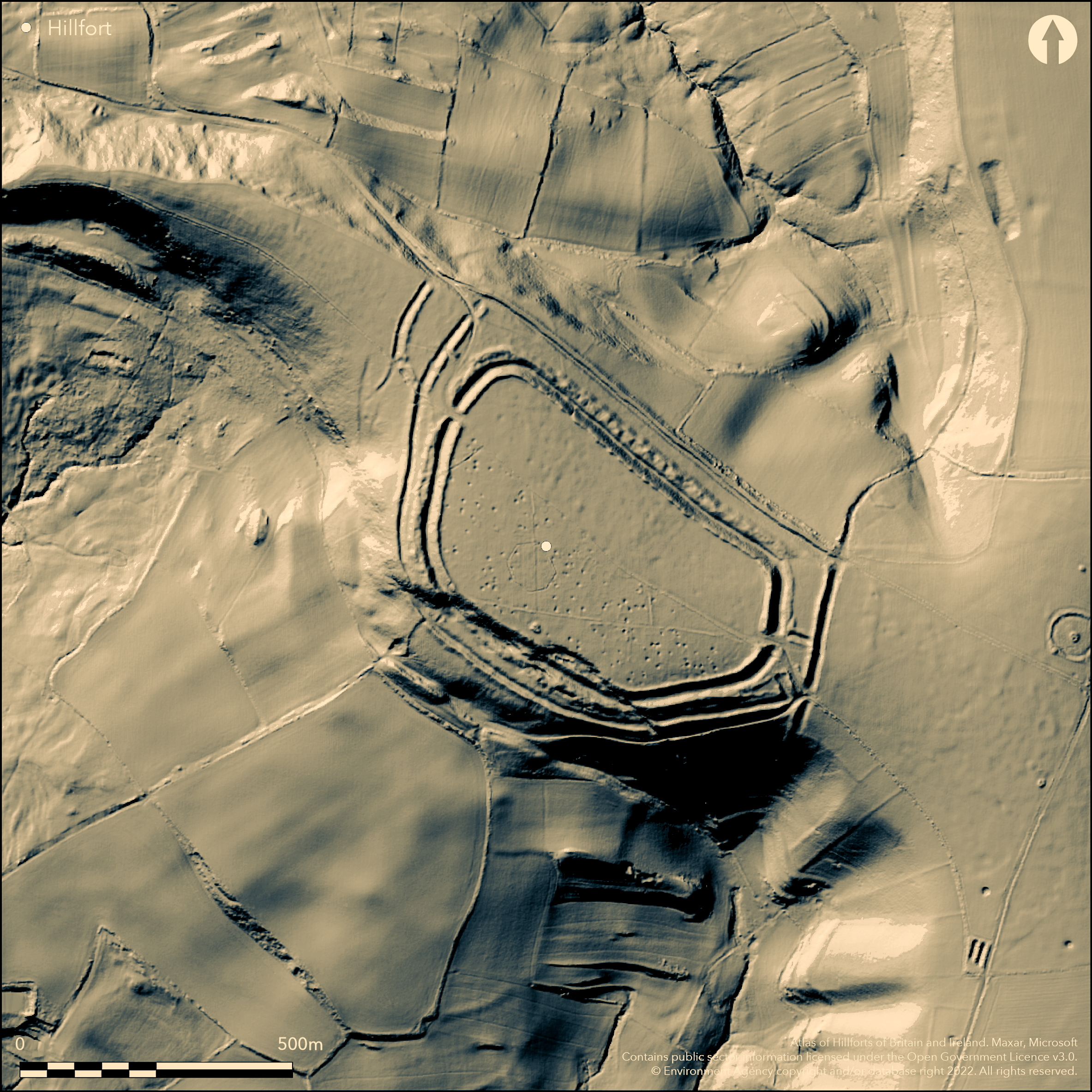
LiDAR 1m DTM Hillshade
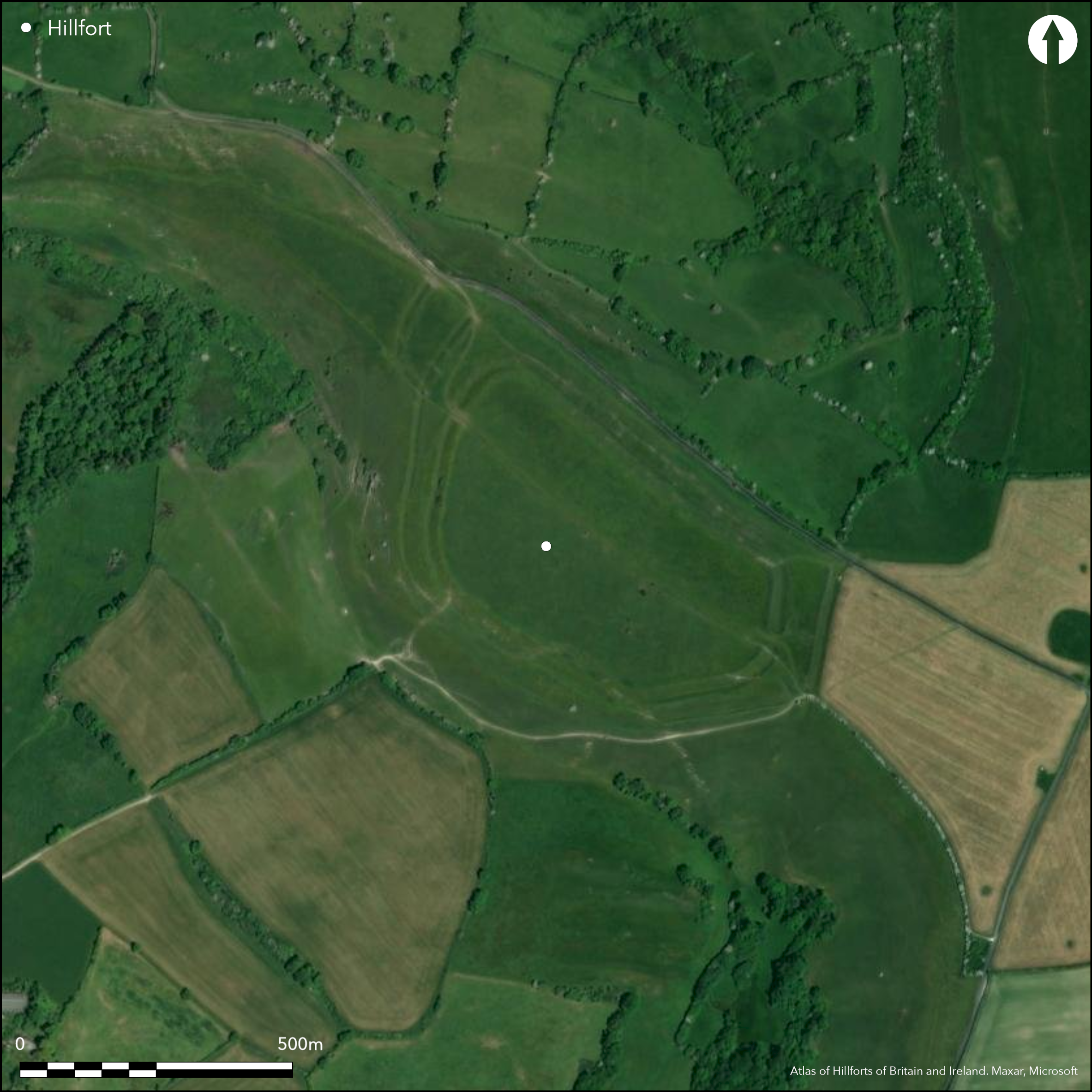
Satellite Imagery
LiDAR 1m DTM Hillshade
Satellite Imagery
Scroll left/right to view further images.
HER: Dorset MDO95 (None)
NMR: SY 59 SW 24 (451411)
SM: 1002684
NGR: SY54079472
X: 354070 Y: 94720 (OSGB36)
Large and commanding contour hillfort located on narrow chalk spur/ridge overlooking vales to W and especially Bride Valley to S. Steep or very steep surrounding slopes, moderate along ridge to SE. Defined by three encircling banks with two medial ditches between, but variations on this around circuit near entrances, and to NW additional rampart, ditch and counterscarp across the ridge, internal enclosed are of 8ha. Outwork to SW possibly later phase of construction and result of notable major landslip, where internal bank along whole of S middle section slipped into ditch below with subsequent reworking of defences at this point, all clearly seen from air. Total area c. 21ha. Two main entrances, SE and NW, both staggered, requiring a diagonal approach, and in the outer rampart inturned, and both with significant berms between outer rampart and next rampart. Through a further bank at foot of hill, covering roughly lateral extent of landslip, the diagonal approach to SE entrance turns outwards and to S. Such sophisticated entrances are a feature of the major hillforts of Dorset. Interior littered with earthworks of probable various dates and hollows of possible contemporary storage pits. Finds from Neolithic onwards indicate early interest in the site. Limited excavations 1900 (Colley March 1901) and by George Rybot 1963-66 (Wells 1978). In former five hollows excavated found to be pits to c. 2m deep with flint knife, saw, scrapers and numerous flakes. Evidence of metal working. Possible hut circles. In later excavations linear banks in interior thought to pre-date the hillfort and the middle-late Iron Age and associated with late Bronze Age pottery. One of the two interior barrows on site produced middle Bronze Age pottery and excavated pits contained middle-late Iron Age pottery. Thus, the pits and other features in interior, producing finds of early Iron Age to late Iron Age date suggest an Iron Age date for the hillfort. Pasture interior and banks generally well-preserved, but regularly ploughed in N part. Affected by gravel digging in past and by lane immediately along NE. N part in private ownership. S part National Trust. On 1st Ed. OS map (1888).
Citizen Science: ✓
Reliability of Data: Confirmed
Reliability of Interpretation: Confirmed
X: -295269 Y: 6577224 (EPSG: 3857)
Longitude: -2.6524507397211528 Latitude: 50.75018965208165 (EPSG:4326)
Country: England; None
Current County or Unitary Authority: Dorset
Historic County: Dorset
Current Parish/Community/Council/Townland: Askerswell; Powerstock
Generally well-preserved, but N half of interior in private ownership and regularly ploughed. That to S unploughed and National Trust site. Affected by gravel digging in past. Affected by lane immediately along NE. Path SE-NW through site through entrances.
| Extant | ✓ |
| Cropmark | ✗ |
| Likely Destroyed | ✗ |
Pasture interior and banks. SSSI.
| Woodland | ✗ |
| Commercial Forestry Plantation | ✗ |
| Parkland | ✗ |
| Pasture (Grazing) | ✓ |
| Arable | ✗ |
| Scrub/Bracken | ✗ |
| Bare Outcrop | ✗ |
| Heather/Moorland | ✗ |
| Heath | ✗ |
| Built-up | ✗ |
| Coastal Grassland | ✗ |
| Other | ✗ |
Large contour hillfort located on narrow chalk spur/ridge overlooking vales to W and especially Bride Valley to S. Steep or very steep surrounding slopes, moderate along ridge to SE.
| Contour Fort | ✓ |
| Partial Contour Fort | ✗ |
| Promontory Fort | ✗ |
| Hillslope Fort | ✗ |
| Level Terrain Fort | ✗ |
| Marsh Fort | ✗ |
| Multiple Enclosure Fort | ✗ |
| Hilltop | ✗ |
| Coastal Promontory | ✗ |
| Inland Promontory | ✗ |
| Valley Bottom | ✗ |
| Knoll/Hillock/Outcrop | ✗ |
| Ridge | ✓ |
| Cliff/Plateau-edge/Scarp | ✗ |
| Hillslope | ✗ |
| Lowland | ✗ |
| Spur | ✓ |
Dominant Topographic Feature: Narrow chalk spur/ridge
| North | ✗ |
| Northeast | ✗ |
| East | ✗ |
| Southeast | ✗ |
| South | ✗ |
| Southwest | ✗ |
| West | ✗ |
| Northwest | ✗ |
| Level | ✓ |
Altitude: 244.0m
Boundary Type: Parish/Townland
In 1963-66 excavations linear banks in interior thought to pre-date the hillfort and the middle-late Iron Age and associated with late Bronze Age pottery. Excavated pits contained middle-late Iron Age pottery. Thus the pits and other features in interior, producing finds of early Iron Age to late Iron Age date, suggest an Iron Age occupation of the hillfort, with general dating evidence of 3rd-1st centuries BC.
Reliability: B - Medium
| Pre 1200BC | ✗ |
| 1200BC - 800BC | ✗ |
| 800BC - 400BC | ✓ |
| 400BC - AD50 | ✓ |
| AD50 - AD400 | ✗ |
| AD400 - AD 800 | ✗ |
| Post AD800 | ✗ |
| Unknown | ✗ |
| Pre Hillfort: | None |
| Post Hillfort: | None |
| Artefactual: | Finds from Neolithic onwards. Dating evidence of 3rd-1st centuries BC. |
In Aubrey's Monumenta Britannica (1665-1693). On 1st Ed. OS map (1888). Excavation H. Colley-March and H. Solly 1900. Excavation G.V.D. Rybot 1963-66. Management survey . K. Parkes and A. Parkes 2008. Visited by Hillfort Study Group 1966, 2016.
| 1st Identified Map Depiction (1888): | OS map. |
| Excavation (1900): | H. Colley-March and H. Solly. |
| Other (1966): | Visit by the Hillfort Study Group |
| Other (2008): | Management survey K. Parkes and A. Parkes |
| Other (2016): | Visit by the Hillfort Study Group |
| 1st Identified Written Reference (None): | Aubrey's Monumenta Britannica. |
| Excavation (None): | G.V.D. Rybot. |
Pits and possible hut circles. Linear earthworks associated with late Bronze Age pottery. In pits flint knife, saw, scrapers and numerous flakes. Evidence of metal working. Broken quern found in hut circle excavation. Chance finds of Iron Age pottery, slingstone, rotary quern and rock hone on or next to enclosure. Barrow excavated 1965 produced middle Bronze Age pottery.
Plentiful water supply close-by.
| None | ✓ |
| Spring | ✗ |
| Stream | ✗ |
| Pool | ✗ |
| Flush | ✗ |
| Well | ✗ |
| Other | ✗ |
Interior littered with contemporary hollow of possible pits c. 1.6m-2m deep. Possible hollows hut circles. Two Bronze Age barrows. Possible quarry pits for extraction of iron ore from underlying Greensand (contemporary with hillfort?).
| No Known Features | ✗ |
| Round Stone Structures | ✗ |
| Rectangular Stone Structures | ✗ |
| Curvilinear Platforms | ✗ |
| Other Roundhouse Evidence | ✓ |
| Pits | ✓ |
| Quarry Hollows | ✓ |
| Other | ✓ |
Five pits excavated 1900. Excavation of hut circle found broken quern stone. Barrow excavated 1965.
| No Known Excavation | ✗ |
| Pits | ✓ |
| Postholes | ✗ |
| Roundhouses | ✓ |
| Rectangular Structures | ✗ |
| Roads/Tracks | ✗ |
| Quarry Hollows | ✗ |
| Other | ✓ |
| Nothing Found | ✗ |
None
| No Known Geophysics | ✓ |
| Pits | ✗ |
| Roundhouses | ✗ |
| Rectangular Structures | ✗ |
| Roads/Tracks | ✗ |
| Quarry Hollows | ✗ |
| Other | ✗ |
| Nothing Found | ✗ |
Linear earthworks associated with late Bronze Age pottery. In pits flint knife, saw, scrapers and numerous flakes, with smithing slag, domestic refuse and waste shale and potsherds. Broken quern. Chance finds of Iron Age pottery, slingstone, rotary quern and rock hone on or next to enclosure. Barrow excavated 1965 produced middle Bronze Age pottery.
| No Known Finds | ✗ |
| Pottery | ✓ |
| Metal | ✓ |
| Metalworking | ✓ |
| Human Bones | ✗ |
| Animal Bones | ✗ |
| Lithics | ✓ |
| Environmental | ✗ |
| Other | ✓ |
None
| APs Not Checked | ✓ |
| None | ✗ |
| Roundhouses | ✗ |
| Rectangular Structures | ✗ |
| Pits | ✗ |
| Postholes | ✗ |
| Roads/Tracks | ✗ |
| Other | ✗ |
Two main entrances, SE and NW, both staggered, requiring a diagonal approach, and in the outer rampart inturned, and both with significant berms between outer rampart and next line of defence. Through a further bank at foot of hill, covering roughly lateral extent of landslip, the diagonal approach to SE entrance turns outwards and to S. Such sophisticated entrances are a feature of the major hillforts of Dorset.
| 2: | None |
| 2: | None |
Guard Chambers: ✗
Chevaux de Frise: ✗
| 1. Over-lapping (South east): | Staggered and inturn to outer bank and through a further bank at foot of hill, covering roughly lateral extent of landslip, the diagonal approach to SE entrance turns outwards and to S. |
| 1. In-turned (South east): | Inturn to outer banlk. |
| 2. Over-lapping (North west): | Staggered and inturn to outer bank. |
| 2. In-turned (North west): | Inturn to outer bank. |
Defined by three encircling banks with two medial ditches between, but variations on this around circuit near entrances, and to NW additional rampart, ditch and counterscarp across the ridge. Outwork to SW possibly later phase of construction and result of notable major landslip, where internal bank along whole of S middle section slipped into ditch below with subsequent reworking of defences at this point with digging of wide trench in E part of slippage and reinstatement of outer ditch and bank below. As result this part does not connect with earlier defences. Additional bank at foot of hill roughly lateral extent of landslip, all clearly seen from air.
| Area 1: | 8.0ha. |
| Total: | 8.0ha. |
Total Footprint Area: 21.0ha.
None
| ✓ | Area complex to ascertain. Interior area c. 8ha without area of landslip, c. 21ha total. Evidence of phasing not only through this rebuild on the SW side, but a structural sequence noted at NW end, where alteration of position of outer entrance coincided with the addition of the additional bank and subsequent outer enclosure. |
| ✓ | Actual quadrants estimated in part. |
| NE Quadrant: | 3 |
| SE Quadrant: | 3 |
| SW Quadrant: | 3 |
| NW Quadrant: | 4 |
| Total: | 4 |
| Partial Univallate | ✗ |
| Univallate | ✗ |
| Partial Bivallate | ✗ |
| Bivallate | ✗ |
| Partial Multivallate | ✗ |
| Multivallate | ✓ |
| Unknown | ✗ |
| Partial Univallate | ✗ |
| Univallate | ✓ |
| Partial Bivallate | ✗ |
| Bivallate | ✗ |
| Partial Multivallate | ✗ |
| Multivallate | ✗ |
Significant berms at both entrances. Counterscarp in part.
| None | ✗ |
| Earthen Bank | ✓ |
| Stone Wall | ✗ |
| Rubble | ✗ |
| Wall-walk | ✗ |
| Evidence of Timber | ✗ |
| Vitrification | ✗ |
| Other Burning | ✗ |
| Palisade | ✗ |
| Counter Scarp Bank | ✓ |
| Berm | ✓ |
| Unfinished | ✗ |
| Other | ✗ |
Linear earthworks in interior excavated. Ramparts or entrances not excavated.
| None | ✗ |
| Earthen Bank | ✗ |
| Stone Wall | ✗ |
| Murus Duplex | ✗ |
| Timber-framed | ✗ |
| Timber-laced | ✗ |
| Vitrification | ✗ |
| Other Burning | ✗ |
| Palisade | ✗ |
| Counter Scarp Bank | ✗ |
| Berm | ✗ |
| Unfinished | ✗ |
| No Known Excavation | ✗ |
| Other | ✓ |
| ✗ | None |
| ✓ | Up to three ditches. |
Number of Ditches: 3
| ✗ | None |
Allcroft, AH. 1908. Earthworks of England, 104-5.
March, H. Colley and Solly, H.S. 1901. A Critical and Material examination of the Hill Fortress called Eggardun, H. Proc Dorset Natur Hist Archaeol Soc, 22, 28-42.
March, H. Colley., 1901. Report of excavations on Eggardun, Dorsetshire. Proc Soc Antiq, 2nd S. xviii. 258-262.
Gale, J. 2003. Prehistoric Dorset, Stroud: Tempus Publishing.
Parkes, A. and Parkes K. undated. Land Use and Historical Ownership of NT Property at Eggardon Hill and Adjacent Area. Manuscript.
RCHM 1952. An inventory of the historical monuments in Dorset, Vol 1, West Dorset, 13-15, London: RCHM.
Solly, H.S. 1921. Eggardun Hill, Henry Shaen Solly, Proc Dorset Natur Hist Archaeol Soc, 42, 31-35
Warne, C. 1872. Ancient Dorset. The Celtic, Roman, Saxon and Danish Antiquities of the County, Bournemouth: For the author, 58-9.
Wells, C. 1978. Excavations by the late George Rybot on Eggardon Hillfort, 1963-66, Proc Dorset Natur Hist Archaeol Soc 100, 54-72.
Accessions Book Dorset Co Museum Dorchester
( 8) Proceedings of the Dorset Natural History and Archaeological Society 73, 1952 Page(s)82
( 9) Proceedings of the Dorset Natural History and Antiquarian Field Club
RCHM 1952. An inventory of the historical monuments in Dorset, Vol 1, West Dorset, , London: RCHM.
Mansell-Pleydell) 1, 1877 Page(s)45
Proceedings of the Dorset Natural History and Archaeological Society (summer meeting) 42, 1921 Page(s)XXXII
( 11) Proceedings of the Dorset Natural History and Antiquarian Field Club 22, 1901 Page(s)XXIV
( 12) Antiquity Publications Limited Antiquity (Hawkes) 5, 1931 Page(s)60-97
See Unpublished Rev RCHM Dorset 1 - West Compton Ph Cross Ridge Dykes 5 & 6
( 15) Proceedings of the Dorset Natural History and Archaeological Society (Farrar RAH) 76, 1954 Page(s)89
( 16) Antiquity Publications Limited Antiquity (J K Joseph) 39, 1965 Page(s)223
( 17) Proceedings of the Dorset Natural History and Archaeological Society (Wells C) 100, 1978 Page(s)54-72
Unpublished revision RCHME Dorset I: West. Undated. (Ackerwell file)
( 19) Proceedings of the Dorset Natural History and Archaeological Society (Farrar RAH) 95, 1973 Page(s)102
Atlas of Hillforts:
Wikidata:
This work is licensed under CC BY-SA 4.0

 and should be cited as:
Lock, Gary and Ralston, Ian. 2024. Atlas of Hillforts of Britain and Ireland. Available at: https://hillforts.arch.ox.ac.uk
Document Version 1.1