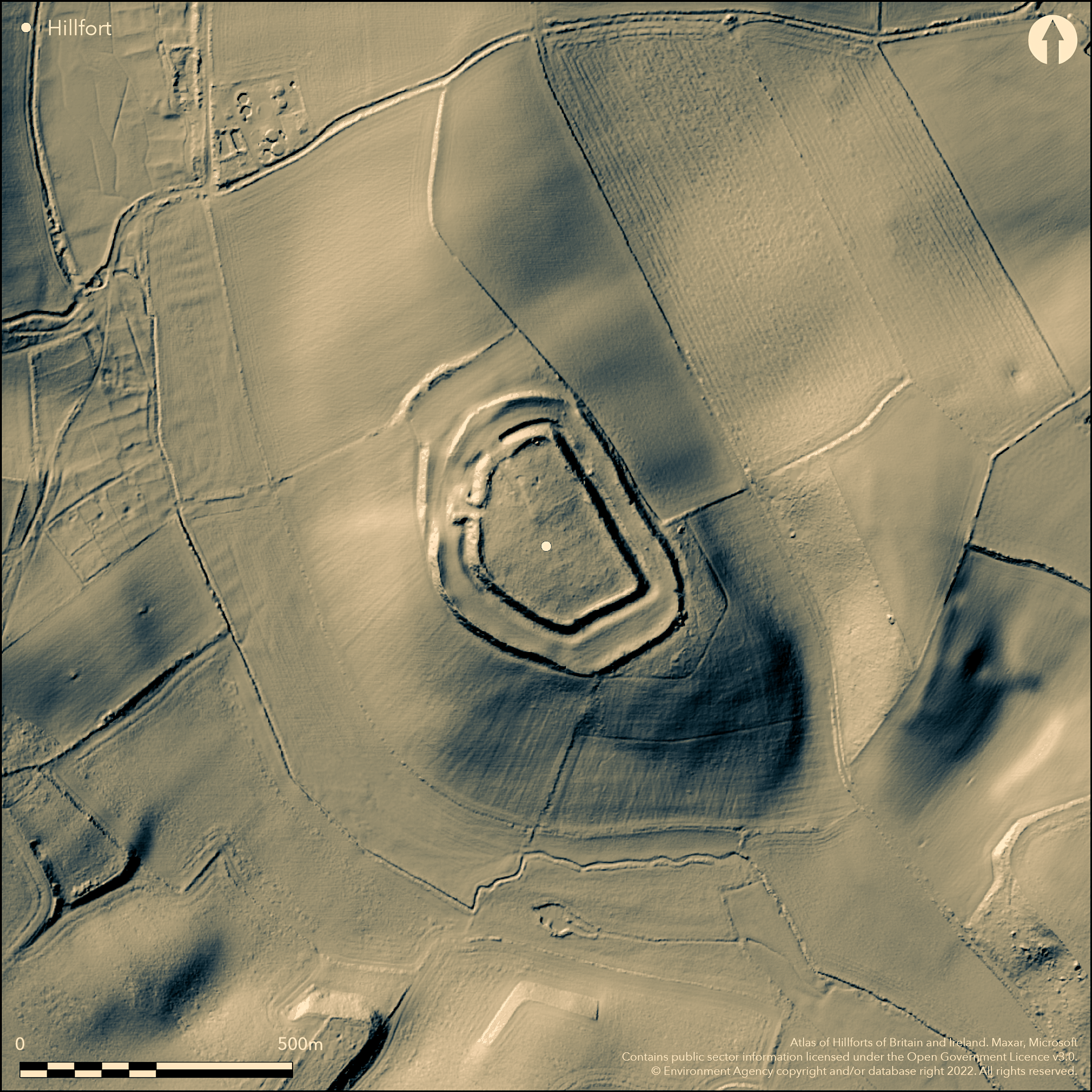
LiDAR 1m DTM Hillshade
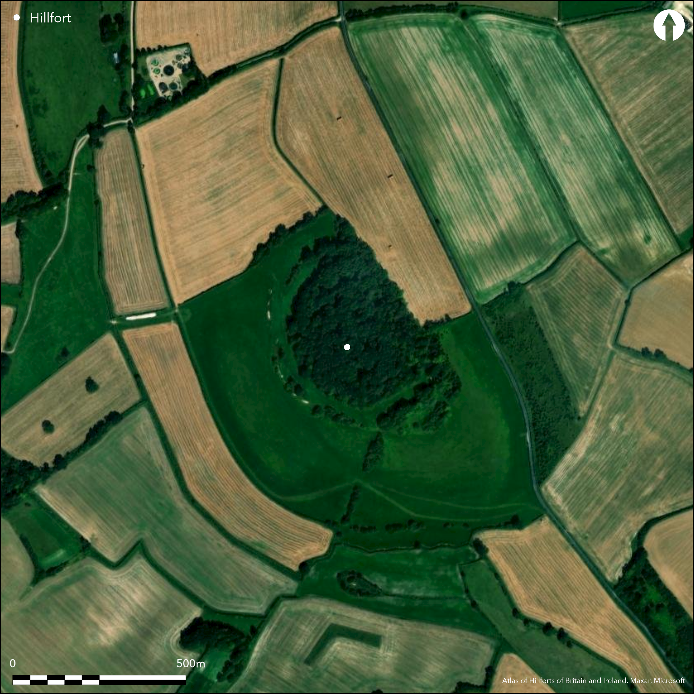
Satellite Imagery
LiDAR 1m DTM Hillshade
Satellite Imagery
Scroll left/right to view further images.
HER: Dorset MDO4360 (None)
NMR: SY 89 NW 7 (455849)
SM: 1019360
NGR: SY80719624
X: 380710 Y: 96240 (OSGB36)
Contour hillfort located in prominent position at S and higher end of chalk spur above Milbourne Brook to W and dry valley to E. Moderate to strong slopes to E, S and W. Steep surrounding slopes, but moderate along ridge to NNE. NE side is notable straight-sided section above slopes. Possible two phases defined by two roughly concentric ramparts and ditches with intervening space between of c. 15m to 27m and enclosing c. 7a on highest point of hill. In effect there is an inner enclosure of c. 2.2ha with rampart to 7m above outer ditch and c. 0.9m above interior. Ditch c. 12m across average and c. 1.5m deep, with discontinuous counterscarp up to 8m wide and 0.6m high. Outside this is the outer enclosure, with rampart where best to 25m wide and to 9m high externally, its interior much reduced by cultivation to outward-facing scarp. an external ditch and counterscarp, noted by Hutchins in 18th century, now not visible and a probable buried feature. Disturbed and complex original entrance on NW where inner ramparts curve outwards creating narrow passage 12m wide, approached from outside by a ramp. Corresponding gap in outer bank which is protected by a third bank covering the gap, now an outward facing scarp 125m long and to 3m high. Two modern gaps, to NNE and S. Low bank, 2.5m wide and 0.4m high, runs around inside the hillfort, adjacent to the rampart; of unknown date and may be plantation enclosure. No obvious features in interior, but later brick built obelisk with stone inscribed `EMP 1761', probably referring to owner at the time, Edmund Morton Pleydell. Warne (1872, 159-61) states that he collected fragments of Roman ware from the site. Wooded interior, less trees on banks, some scrub and grassy areas between the enclosures. Generally well-preserved despite loss of outer ditch and some bank loss through past cultivation and modern access tracks into interior. On 1st Ed. OS map (1888-89). Minimal investigations, undated.
Citizen Science: ✓
Reliability of Data: Confirmed
Reliability of Interpretation: Confirmed
X: -253242 Y: 6579893 (EPSG: 3857)
Longitude: -2.2749128171119994 Latitude: 50.765359788216244 (EPSG:4326)
Country: England; None
Current County or Unitary Authority: Dorset
Historic County: Dorset
Current Parish/Community/Council/Townland: Milborne St Andrew; Tolpuddle
Generally well-preserved despite loss of outer ditch and some bank loss through past cultivation and modern access tracks into interior. On Heritage at Risk Register (2015).
| Extant | ✓ |
| Cropmark | ✗ |
| Likely Destroyed | ✗ |
Wooded interior, less trees on banks, some scrub and grassy areas between the enclosures. banks. Brick obelisk.
| Woodland | ✓ |
| Commercial Forestry Plantation | ✗ |
| Parkland | ✗ |
| Pasture (Grazing) | ✓ |
| Arable | ✗ |
| Scrub/Bracken | ✓ |
| Bare Outcrop | ✗ |
| Heather/Moorland | ✗ |
| Heath | ✗ |
| Built-up | ✗ |
| Coastal Grassland | ✗ |
| Other | ✓ |
Contour hillfort located in prominent position at S and higher end of chalk spur above Milbourne Brook to W and dry valley to E. Moderate to strong slopes to E, S and W. Steep surrounding slopes, but moderate along ridge to NNE. NE side is notable straight-sided section above slopes.
| Contour Fort | ✓ |
| Partial Contour Fort | ✗ |
| Promontory Fort | ✗ |
| Hillslope Fort | ✗ |
| Level Terrain Fort | ✗ |
| Marsh Fort | ✗ |
| Multiple Enclosure Fort | ✗ |
| Hilltop | ✗ |
| Coastal Promontory | ✗ |
| Inland Promontory | ✗ |
| Valley Bottom | ✗ |
| Knoll/Hillock/Outcrop | ✗ |
| Ridge | ✗ |
| Cliff/Plateau-edge/Scarp | ✗ |
| Hillslope | ✗ |
| Lowland | ✗ |
| Spur | ✓ |
Dominant Topographic Feature: spur
| North | ✗ |
| Northeast | ✗ |
| East | ✗ |
| Southeast | ✗ |
| South | ✗ |
| Southwest | ✗ |
| West | ✗ |
| Northwest | ✗ |
| Level | ✓ |
Altitude: 102.0m
Boundary Type: Parish/Townland
None.
Reliability: D - None
| Pre 1200BC | ✗ |
| 1200BC - 800BC | ✗ |
| 800BC - 400BC | ✗ |
| 400BC - AD50 | ✗ |
| AD50 - AD400 | ✗ |
| AD400 - AD 800 | ✗ |
| Post AD800 | ✗ |
| Unknown | ✓ |
| Pre Hillfort: | None |
| Post Hillfort: | Within is brick built obelisk with stone inscribed `EMP 1761', probably referring to owner at the time, Edmund Morton Pleydell. |
On 1st Ed. OS map (1888-89). Recent LiDAR survey 2014.
| LiDAR Survey (2014): | Citizen Science information. |
| 1st Identified Map Depiction (None): | OS map. |
Warne (1872, 159-61) states that he collected fragments of Roman ware from the site. Possible worked flint recent chance find.
None
| None | ✓ |
| Spring | ✗ |
| Stream | ✗ |
| Pool | ✗ |
| Flush | ✗ |
| Well | ✗ |
| Other | ✗ |
None
| No Known Features | ✓ |
| Round Stone Structures | ✗ |
| Rectangular Stone Structures | ✗ |
| Curvilinear Platforms | ✗ |
| Other Roundhouse Evidence | ✗ |
| Pits | ✗ |
| Quarry Hollows | ✗ |
| Other | ✗ |
None
| No Known Excavation | ✓ |
| Pits | ✗ |
| Postholes | ✗ |
| Roundhouses | ✗ |
| Rectangular Structures | ✗ |
| Roads/Tracks | ✗ |
| Quarry Hollows | ✗ |
| Other | ✗ |
| Nothing Found | ✗ |
None
| No Known Geophysics | ✓ |
| Pits | ✗ |
| Roundhouses | ✗ |
| Rectangular Structures | ✗ |
| Roads/Tracks | ✗ |
| Quarry Hollows | ✗ |
| Other | ✗ |
| Nothing Found | ✗ |
Warne (1872, 159-61) states that he collected fragments of Roman ware from the site. Possible worked flint recent chance find.
| No Known Finds | ✗ |
| Pottery | ✓ |
| Metal | ✗ |
| Metalworking | ✗ |
| Human Bones | ✗ |
| Animal Bones | ✗ |
| Lithics | ✓ |
| Environmental | ✗ |
| Other | ✗ |
None
| APs Not Checked | ✓ |
| None | ✗ |
| Roundhouses | ✗ |
| Rectangular Structures | ✗ |
| Pits | ✗ |
| Postholes | ✗ |
| Roads/Tracks | ✗ |
| Other | ✗ |
Disturbed and complex original entrance on NW where inner ramparts curve outwards creating narrow passage 12m wide, approached from outside by a ramp. Corresponding gap in outer bank which is protected by a third bank covering the gap, now an outward facing scarp 125m long and to 3m high. A gap in the inner rampart on NNE, to NE of entrance, not original and modern gap to S pushed through for vehicle access.
| 3: | A gap in the inner rampart on NNE, to NE of entrance, not original and modern gap to S pushed through for vehicle access. |
| 2: | None |
Guard Chambers: ✗
Chevaux de Frise: ✗
| 1. Out-turned (North west): | Disturbed and complex original entrance on W where inner ramparts curve outwards creating narrow passage 12m wide, approached from outside by a ramp. Corresponding gap in outer bank which is protected by a third bank covering the gap, now an outward facing scarp 125m long and to 3m high. |
| 1. Passage-way/Corridor (North west): | Narrow passage 12m wide. |
| 1. Outworks (North west): | Outer bank protected by a third bank covering the gap. |
Defined by two roughly concentric ramparts and ditches with intervening space between of c. 15m to 27m and enclosing c. 7a on highest point of hill. In effect there is an inner enclosure of c. 2.2ha with rampart to 7m above outer ditch and c. 0.9m above interior. Ditch c. 12m across average and c. 1.5m deep, with discontinuous counterscarp up to 8m wide and 0.6m high. Outside this is the outer enclosure, with rampart where best to 25m wide and to 9m high externally, its interior much reduced by cultivation to outward-facing scarp. an external ditch and counterscarp, noted by Hutchins in 18th century, now not visible and a probable buried feature.
| Area 1: | 2.2ha. |
| Area 2: | 7.0ha. |
| Total: | 7.0ha. |
Total Footprint Area: Noneha.
None
| ✓ | Possible two phases giving, in effect, two concentric enclosures. |
| ✓ | None |
| NE Quadrant: | 2 |
| SE Quadrant: | 2 |
| SW Quadrant: | 2 |
| NW Quadrant: | 2 |
| Total: | 2 |
| Partial Univallate | ✗ |
| Univallate | ✗ |
| Partial Bivallate | ✗ |
| Bivallate | ✓ |
| Partial Multivallate | ✗ |
| Multivallate | ✗ |
| Unknown | ✗ |
| Partial Univallate | ✗ |
| Univallate | ✓ |
| Partial Bivallate | ✗ |
| Bivallate | ✗ |
| Partial Multivallate | ✗ |
| Multivallate | ✗ |
Discontinuous counterscarp to inner enclosure, buried feature to outer bank.
| None | ✗ |
| Earthen Bank | ✓ |
| Stone Wall | ✗ |
| Rubble | ✗ |
| Wall-walk | ✗ |
| Evidence of Timber | ✗ |
| Vitrification | ✗ |
| Other Burning | ✗ |
| Palisade | ✗ |
| Counter Scarp Bank | ✓ |
| Berm | ✗ |
| Unfinished | ✗ |
| Other | ✗ |
None
| None | ✗ |
| Earthen Bank | ✗ |
| Stone Wall | ✗ |
| Murus Duplex | ✗ |
| Timber-framed | ✗ |
| Timber-laced | ✗ |
| Vitrification | ✗ |
| Other Burning | ✗ |
| Palisade | ✗ |
| Counter Scarp Bank | ✗ |
| Berm | ✗ |
| Unfinished | ✗ |
| No Known Excavation | ✓ |
| Other | ✗ |
| ✗ | None |
| ✓ | Ditch to outer bank not visible and buried feature. |
Number of Ditches: 2
| ✗ | None |
Gale, J. 2003. Prehistoric Dorset, Stroud: Tempus Publishing.
RCHME 1970. An inventory of historical monuments in the County of Dorset, Vol 3, No 18, pt 2, Central Dorset, 179-81, London: RCHME.
Warne, C. 1872. Ancient Dorset. The Celtic, Roman, Saxon and Danish Antiquities of the County, Bournemouth: For the author, 159-61.
Atlas of Hillforts:
Wikidata:
This work is licensed under CC BY-SA 4.0

 and should be cited as:
Lock, Gary and Ralston, Ian. 2024. Atlas of Hillforts of Britain and Ireland. Available at: https://hillforts.arch.ox.ac.uk
Document Version 1.1