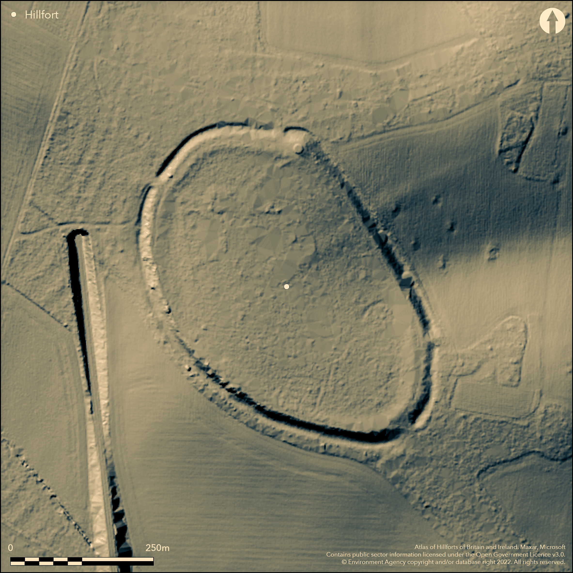
LiDAR 1m DTM Hillshade
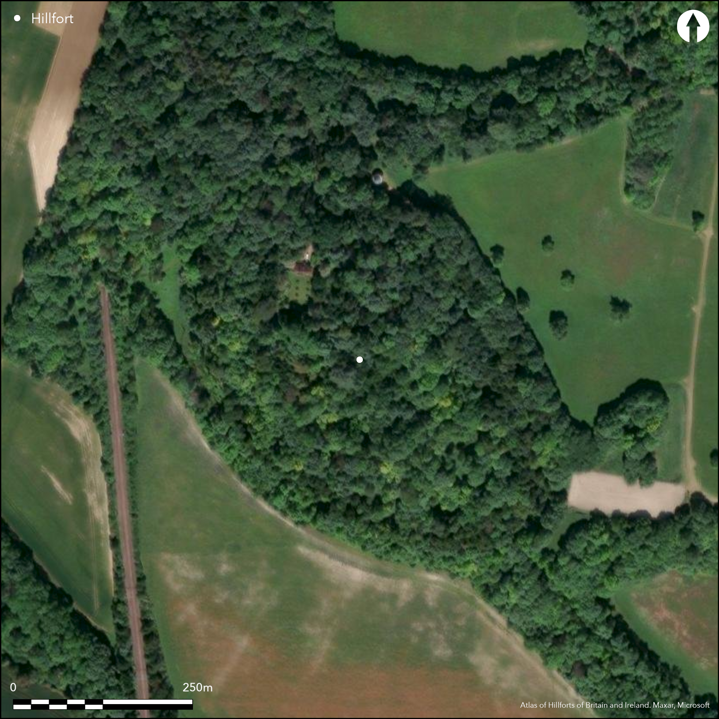
Satellite Imagery
LiDAR 1m DTM Hillshade
Satellite Imagery
Scroll left/right to view further images.
HER: Essex 151 (None)
NMR: TL 53 NW 5 (373665)
SM: 1011473
NGR: TL 5155 3818
X: 551550 Y: 238180 (OSGB36)
A univallate hillfort lying on the summit of Ring Hill to the W of Audley End, known as Starbury in the medieval period (Morant 1768). The site lies within woodland on a natural chalk spur overlooking the River Cam. Oval in form it measures 400m NW-SE by 260m transversely, enclosing 4.3ha. The ditch is generally slight, 5.0m wide and up to 0.8m deep, but on the level north-western end it reaches a depth of 1.8m. The surviving traces of a 12m wide internal rampart, formed by enhancing the natural scarp, stands 4.7m high on the SW and NE sides. It was mostly levelled in the 18th century but can still be traced around much of the circuit (Oswald 1999). It is separated from the scarp/ditch by a level berm 8m wide. A counterscarp up to 0.3m high lies approximately 1m from the ditch. The site is strengthened by the natural steepness of the hill. Four gaps, in the SW, W, N and NE have been identified in the rampart but the location of an original entrance is unknown. Roman coins have been recorded from within or near to the hillfort (Neville 1854). A railway cutting has caused a slight disturbance to 100m of the ditch in the W. The Temple of Victory, built in 1771-2 lies inside the ramparts in the NE corner. A cottage lies in the N. A warren, and in the 18th century a menagerie, also once lay within the interior. No features contemporary with the use of the hillfort are recorded. The site is recorded on 1877, 1:2,500 OS mapping. Scheduled. Undated.
Citizen Science: ✗
Reliability of Data: Confirmed
Reliability of Interpretation: Confirmed
X: 23076 Y: 6803978 (EPSG: 3857)
Longitude: 0.20729296222576427 Latitude: 52.021300533273475 (EPSG:4326)
Country: England
Current County or Unitary Authority: Essex
Historic County: Essex
Current Parish/Community/Council/Townland: Littlebury
None
| Extant | ✓ |
| Cropmark | ✗ |
| Likely Destroyed | ✗ |
None
| Woodland | ✓ |
| Commercial Forestry Plantation | ✗ |
| Parkland | ✗ |
| Pasture (Grazing) | ✗ |
| Arable | ✗ |
| Scrub/Bracken | ✗ |
| Bare Outcrop | ✗ |
| Heather/Moorland | ✗ |
| Heath | ✗ |
| Built-up | ✗ |
| Coastal Grassland | ✗ |
| Other | ✗ |
A hillslope fort lying at 97m OD on the shoulder of a natural chalk spur overlooking the River Cam. The ground slopes away to the SE
| Contour Fort | ✗ |
| Partial Contour Fort | ✗ |
| Promontory Fort | ✗ |
| Hillslope Fort | ✓ |
| Level Terrain Fort | ✗ |
| Marsh Fort | ✗ |
| Multiple Enclosure Fort | ✗ |
| Hilltop | ✗ |
| Coastal Promontory | ✗ |
| Inland Promontory | ✗ |
| Valley Bottom | ✗ |
| Knoll/Hillock/Outcrop | ✗ |
| Ridge | ✗ |
| Cliff/Plateau-edge/Scarp | ✗ |
| Hillslope | ✓ |
| Lowland | ✗ |
| Spur | ✓ |
Dominant Topographic Feature: Natural chalk spur overlooking the River Cam
| North | ✗ |
| Northeast | ✗ |
| East | ✗ |
| Southeast | ✓ |
| South | ✗ |
| Southwest | ✗ |
| West | ✗ |
| Northwest | ✗ |
| Level | ✗ |
Altitude: 97.0m
N/A
The site is undated, but probably early to middle Iron Age based on the morphology of the earthworks
Reliability: D - None
| Pre 1200BC | ✗ |
| 1200BC - 800BC | ✗ |
| 800BC - 400BC | ✗ |
| 400BC - AD50 | ✗ |
| AD50 - AD400 | ✗ |
| AD400 - AD 800 | ✗ |
| Post AD800 | ✗ |
| Unknown | ✓ |
| Pre Hillfort: | None |
| Post Hillfort: | Railway cuts the ditch in the W. The Temple of Victory, built in 1771-2 lies inside the ramparts in the NE corner. A cottage lies in the N. Warren, and in the 18th century a menagerie, |
Recorded on 1877, 1:2,500 OS mapping. Field investigations in 1969 and 1989. 1995 RCHME measured earthwork survey, ref. no. 1044792. 2009-10. Air Photograph Interpretation Audley End environs: aerial photograph and lidar survey and analysis. Scheduled
| 1st Identified Written Reference (1768): | Known as Starbury in the medieval period |
| 1st Identified Map Depiction (1877): | None |
| Other (1923): | Scheduled |
| Other (1969): | Field investigation |
| Other (1989): | Field investigation |
| Earthwork Survey (1995): | None |
| LiDAR Survey (2009): | None |
No features contemporary with the use of the hillfort are recorded.
The River Cam flows to the E
| None | ✓ |
| Spring | ✗ |
| Stream | ✗ |
| Pool | ✗ |
| Flush | ✗ |
| Well | ✗ |
| Other | ✗ |
None
| No Known Features | ✓ |
| Round Stone Structures | ✗ |
| Rectangular Stone Structures | ✗ |
| Curvilinear Platforms | ✗ |
| Other Roundhouse Evidence | ✗ |
| Pits | ✗ |
| Quarry Hollows | ✗ |
| Other | ✗ |
None
| No Known Excavation | ✓ |
| Pits | ✗ |
| Postholes | ✗ |
| Roundhouses | ✗ |
| Rectangular Structures | ✗ |
| Roads/Tracks | ✗ |
| Quarry Hollows | ✗ |
| Other | ✗ |
| Nothing Found | ✗ |
None
| No Known Geophysics | ✓ |
| Pits | ✗ |
| Roundhouses | ✗ |
| Rectangular Structures | ✗ |
| Roads/Tracks | ✗ |
| Quarry Hollows | ✗ |
| Other | ✗ |
| Nothing Found | ✗ |
Roman coins have been recorded from within or near to the hillfort (Neville 1854)
| No Known Finds | ✗ |
| Pottery | ✗ |
| Metal | ✗ |
| Metalworking | ✗ |
| Human Bones | ✗ |
| Animal Bones | ✗ |
| Lithics | ✗ |
| Environmental | ✗ |
| Other | ✓ |
Wooded
| APs Not Checked | ✓ |
| None | ✗ |
| Roundhouses | ✗ |
| Rectangular Structures | ✗ |
| Pits | ✗ |
| Postholes | ✗ |
| Roads/Tracks | ✗ |
| Other | ✗ |
The location of original entrances is unknown
| 4: | None |
| 2: | None |
Guard Chambers: ✗
Chevaux de Frise: ✗
Univallate hillfort. Oval in form it measures 400m NW-SE by 260m transversely, enclosing 4.3ha. The ditch is generally slight, 5.0m wide and up to 0.8m deep, but on the level north-western end it reaches a depth of 1.8m. The surviving traces of a 12m wide internal rampart, formed by enhancing the natural scarp, stands 4.7m high on the SW and NE sides. It was mostly levelled in the 18th century but can still be traced around much of the circuit (Oswald 1999). It is separated from the scarp/ditch by a level berm 8m wide. A counterscarp up to 0.3m high lies approximately 1m from the ditch. The site is strengthened by the natural steepness of the hill.
| Area 1: | 4.3ha. |
| Total: | 4.3ha. |
Total Footprint Area: Noneha.
None
| ✗ | None |
| ✓ | Mostly levelled but can still be traced |
| NE Quadrant: | 1 |
| SE Quadrant: | 1 |
| SW Quadrant: | 1 |
| NW Quadrant: | 1 |
| Total: | 1 |
| Partial Univallate | ✗ |
| Univallate | ✓ |
| Partial Bivallate | ✗ |
| Bivallate | ✗ |
| Partial Multivallate | ✗ |
| Multivallate | ✗ |
| Unknown | ✗ |
| Partial Univallate | ✗ |
| Univallate | ✗ |
| Partial Bivallate | ✗ |
| Bivallate | ✗ |
| Partial Multivallate | ✗ |
| Multivallate | ✗ |
None
| None | ✗ |
| Earthen Bank | ✓ |
| Stone Wall | ✗ |
| Rubble | ✗ |
| Wall-walk | ✗ |
| Evidence of Timber | ✗ |
| Vitrification | ✗ |
| Other Burning | ✗ |
| Palisade | ✗ |
| Counter Scarp Bank | ✓ |
| Berm | ✓ |
| Unfinished | ✗ |
| Other | ✗ |
None
| None | ✗ |
| Earthen Bank | ✗ |
| Stone Wall | ✗ |
| Murus Duplex | ✗ |
| Timber-framed | ✗ |
| Timber-laced | ✗ |
| Vitrification | ✗ |
| Other Burning | ✗ |
| Palisade | ✗ |
| Counter Scarp Bank | ✗ |
| Berm | ✗ |
| Unfinished | ✗ |
| No Known Excavation | ✓ |
| Other | ✗ |
| ✗ | None |
| ✓ | None |
Number of Ditches: 1
| ✗ | None |
Morant, P. 1768. History and Antiquities of Essex, II London
Neville, R.C. 1854. Ancient Cambridgeshire: A Comprehensive survey of vestiges of Early Occupation in Cambridgeshire and Adjacent Parts of Essex, Chiefly the Result of Personal Observation. Arch J. 11, 214
Oswald, A. 1999. A hillfort on Ring Hill, Littlebury, Essex. In P. Pattison, D. Field and S. Ainsworth (eds) Patterns of the Past: Essays in Landscape Archaeology for Christopher Taylor, 23-28.
Atlas of Hillforts:
Wikidata:
This work is licensed under CC BY-SA 4.0

 and should be cited as:
Lock, Gary and Ralston, Ian. 2024. Atlas of Hillforts of Britain and Ireland. Available at: https://hillforts.arch.ox.ac.uk
Document Version 1.1