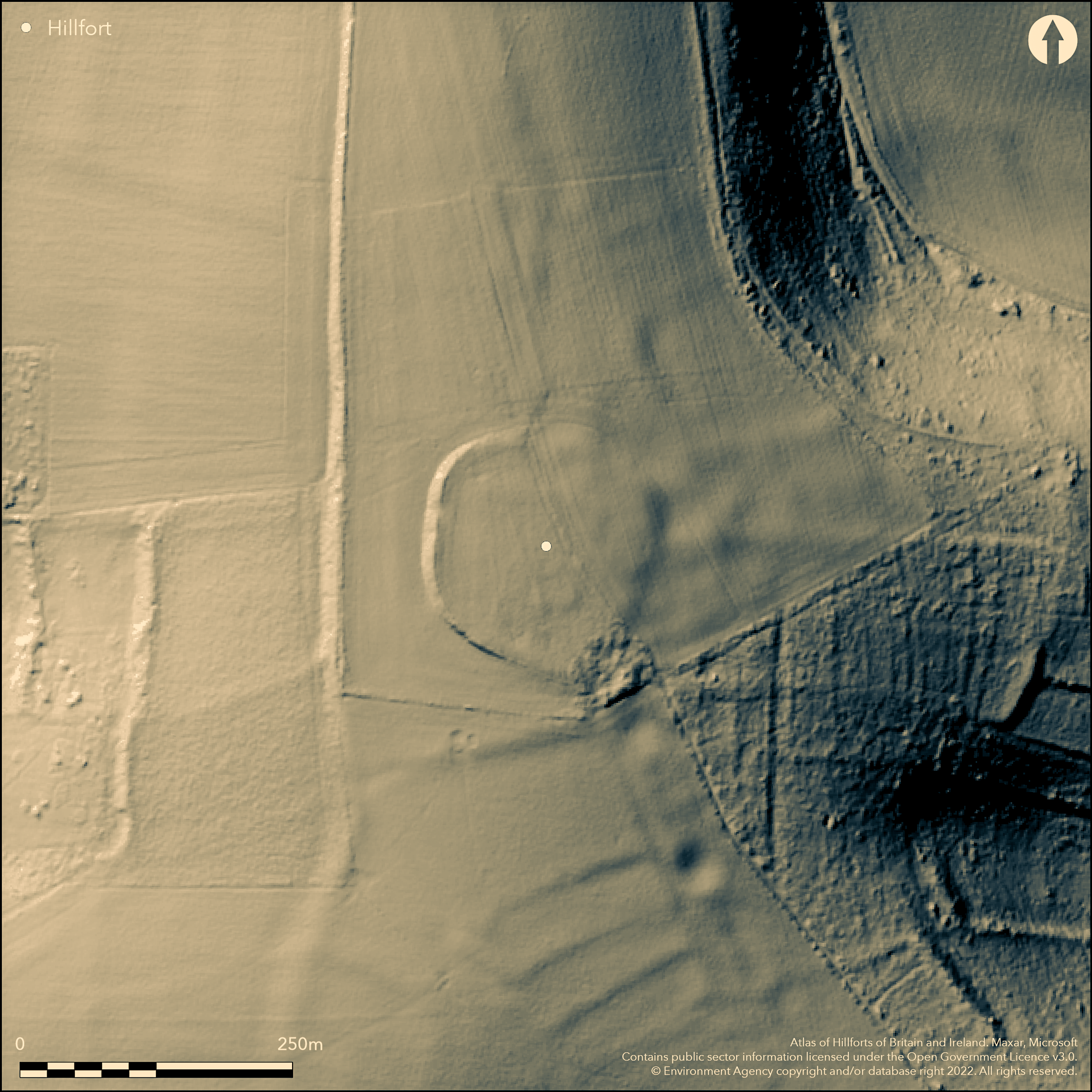
LiDAR 1m DTM Hillshade
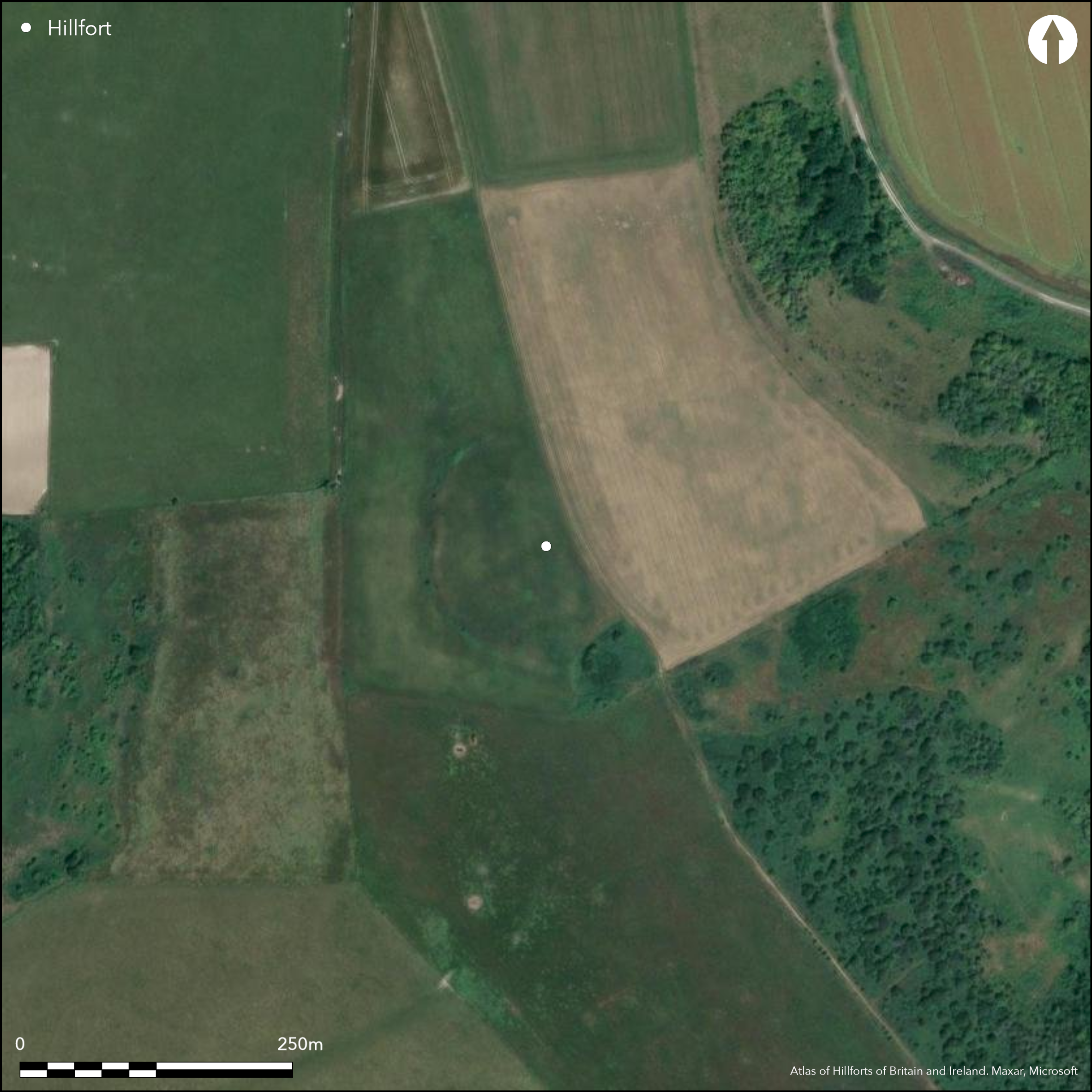
Satellite Imagery
LiDAR 1m DTM Hillshade
Satellite Imagery
Scroll left/right to view further images.
HER: West Sussex MWS6466 (None)
NMR: TQ 20 NW 3 (398683)
SM: 1015124
NGR: TQ2292008393
X: 522918 Y: 108403 (OSGB36)
Univallate partial contour hillfort located on the NNW-SSE aligned chalk ridge of Thundersbarrow Hill on the Sussex Downs. Steep downland surrounds, rather more on NE and less on S. Site tipped across contours to SSE. Associated with a Bronze Age Martin Down style enclosure, within the later hillfort, Romano-British farmstead/aggregate village and associated regular field system nearby and WWI and WWII features on the site. Site almost destroyed by ploughing. Two phases of site noted in 1932 excavations (Curwen 1933), with the probable Iron Age, hillfort enclosing c. 1.2ha with the Bronze Age enclosure within c. 0.49ha. Latter partly excavated (Rudling 1985) as roughly square, slightly raised, enclosure with infilled ditch, now more or less ploughed out. Fragments of bone, pottery sherds of c. ninth and tenth centuries BC, and worked flint found in ditch fills. The roughly circular hillfort, formerly with bank and ditch, now partly levelled, and survives to E largely in buried form. Pottery excavated suggests construction during the sixth century BC and continued in use until the mid third century BC. Hillfort then abandoned, with Romano-British farmstead/aggregate village and field system on E, S and W sides of ridge (now cropmarks) established, c. 50 BC ,nearby to E and lasting till c. AD 400. Remains of inturned entrances in the N and S sides. On 1st Ed. OS map (1873-5).
Citizen Science: ✗
Reliability of Data: Confirmed
Reliability of Interpretation: Confirmed
X: -28364 Y: 6596922 (EPSG: 3857)
Longitude: -0.25479819390004343 Latitude: 50.862013499179604 (EPSG:4326)
Country: England; None
Current County or Unitary Authority: West Sussex
Historic County: Sussex
Current Parish/Community/Council/Townland: Upper Beeding; Shoreham by Sea
Nearly gone. Partly levelled by modern ploughing and mostly buried feature in E. WWII damage.
| Extant | ✓ |
| Cropmark | ✗ |
| Likely Destroyed | ✓ |
Cultivated. WWII slit trenches.
| Woodland | ✗ |
| Commercial Forestry Plantation | ✗ |
| Parkland | ✗ |
| Pasture (Grazing) | ✓ |
| Arable | ✗ |
| Scrub/Bracken | ✗ |
| Bare Outcrop | ✗ |
| Heather/Moorland | ✗ |
| Heath | ✗ |
| Built-up | ✗ |
| Coastal Grassland | ✗ |
| Other | ✓ |
Univallate partial contour hillfort located on the NNW-SSE aligned chalk ridge of Thundersbarrow Hill on the Sussex Downs. Steep downland surrounds, rather more on NE and less on S. Site tipped across contours to SSE.
| Contour Fort | ✗ |
| Partial Contour Fort | ✓ |
| Promontory Fort | ✗ |
| Hillslope Fort | ✗ |
| Level Terrain Fort | ✗ |
| Marsh Fort | ✗ |
| Multiple Enclosure Fort | ✗ |
| Hilltop | ✗ |
| Coastal Promontory | ✗ |
| Inland Promontory | ✗ |
| Valley Bottom | ✗ |
| Knoll/Hillock/Outcrop | ✗ |
| Ridge | ✓ |
| Cliff/Plateau-edge/Scarp | ✗ |
| Hillslope | ✗ |
| Lowland | ✗ |
| Spur | ✗ |
Dominant Topographic Feature: Ridge
| North | ✗ |
| Northeast | ✗ |
| East | ✗ |
| Southeast | ✓ |
| South | ✗ |
| Southwest | ✗ |
| West | ✗ |
| Northwest | ✗ |
| Level | ✗ |
Altitude: 150.0m
Boundary Type: Parish/Townland
Hillfort probably Iron Age, but associated with a Bronze Age Martin Down style enclosure, Romano-British farmstead/aggregate village and associated regular field system. Fragments of bone, pottery sherds of c. ninth and tenth centuries BC, and worked flint found in ditch fills of Bronze Age enclosure. Pottery excavated hillfort suggests construction during the sixth century BC and continued in use until the mid third century BC. Hillfort then abandoned with Romano-British farmstead and field system established c. 50 BC nearby to E and lasting till c. AD 400.
Reliability: B - Medium
| Pre 1200BC | ✗ |
| 1200BC - 800BC | ✓ |
| 800BC - 400BC | ✓ |
| 400BC - AD50 | ✓ |
| AD50 - AD400 | ✗ |
| AD400 - AD 800 | ✗ |
| Post AD800 | ✗ |
| Unknown | ✗ |
| Pre Hillfort: | None |
| Post Hillfort: | None |
| Artefactual: | Fragments of bone, pottery sherds of c. ninth and tenth centuries BC, and worked flint found in ditch fills of Bronze Age enclosure. Pottery excavated hillfort suggests construction during the sixth century BC and continued in use until the mid third century BC. |
On 1st Ed. OS map (1873-5). 1929-32 Excavation E.C. Curwen 1929-32. Geophysical Survey Ancient Monuments Laboratory 1986. Plough damage assessment excavations D. Rudling 1985.
| Excavation (1985): | D. Rudling plough damage assessment excavations. |
| Geophysical Survey (1986): | Magnetometer and resistivity surveys Ancient Monuments Laboratory. |
| 1st Identified Map Depiction (None): | OS map. |
| Excavation (None): | E.C. Curwen. |
Geophysics found faint scatter of features detected against disturbed background. Resistivity survey revealed traces of an inner enclosure. Fragments of bone, pottery sherds of c. ninth and tenth centuries BC, and worked flint found in ditch fills of Bronze Age enclosure. Pottery excavated hillfort suggests construction during the sixth century BC and continued in use until the mid third century BC.
None
| None | ✓ |
| Spring | ✗ |
| Stream | ✗ |
| Pool | ✗ |
| Flush | ✗ |
| Well | ✗ |
| Other | ✗ |
None
| No Known Features | ✓ |
| Round Stone Structures | ✗ |
| Rectangular Stone Structures | ✗ |
| Curvilinear Platforms | ✗ |
| Other Roundhouse Evidence | ✗ |
| Pits | ✗ |
| Quarry Hollows | ✗ |
| Other | ✗ |
None
| No Known Excavation | ✗ |
| Pits | ✗ |
| Postholes | ✗ |
| Roundhouses | ✗ |
| Rectangular Structures | ✗ |
| Roads/Tracks | ✗ |
| Quarry Hollows | ✗ |
| Other | ✗ |
| Nothing Found | ✓ |
Faint scatter of features detected against disturbed background. Resistivity survey revealed traces of an inner enclosure.
| No Known Geophysics | ✗ |
| Pits | ✗ |
| Roundhouses | ✗ |
| Rectangular Structures | ✗ |
| Roads/Tracks | ✗ |
| Quarry Hollows | ✗ |
| Other | ✓ |
| Nothing Found | ✗ |
Fragments of bone, pottery sherds of c. ninth and tenth centuries BC, and worked flint found in ditch fills of Bronze Age enclosure. Pottery excavated hillfort suggests construction during the sixth century BC and continued in use until the mid third century BC.
| No Known Finds | ✗ |
| Pottery | ✓ |
| Metal | ✗ |
| Metalworking | ✗ |
| Human Bones | ✗ |
| Animal Bones | ✓ |
| Lithics | ✓ |
| Environmental | ✗ |
| Other | ✗ |
None
| APs Not Checked | ✓ |
| None | ✗ |
| Roundhouses | ✗ |
| Rectangular Structures | ✗ |
| Pits | ✗ |
| Postholes | ✗ |
| Roads/Tracks | ✗ |
| Other | ✗ |
Remains of inturned entrances on the N and S sides.
| 2: | None |
| 2: | None |
Guard Chambers: ✗
Chevaux de Frise: ✗
| 1. In-turned (North): | None |
| 2. In-turned (South): | None |
Bronze Age inner enclosure roughly square bank with infilled ditch, now more or less ploughed out. The roughly circular surrounding hillfort, formerly with bank and ditch, now partly levelled, and survives to E largely in buried form.
| Area 1: | 1.2ha. |
| Total: | 1.2ha. |
Total Footprint Area: Noneha.
None
| ✓ | The two phases of site noted in 1932 excavations. |
| ✓ | Formerly surrounding bank and ditch, now virtually ploughed out. |
| NE Quadrant: | 1 |
| SE Quadrant: | 1 |
| SW Quadrant: | 1 |
| NW Quadrant: | 1 |
| Total: | 1 |
| Partial Univallate | ✗ |
| Univallate | ✓ |
| Partial Bivallate | ✗ |
| Bivallate | ✗ |
| Partial Multivallate | ✗ |
| Multivallate | ✗ |
| Unknown | ✗ |
| Partial Univallate | ✗ |
| Univallate | ✗ |
| Partial Bivallate | ✗ |
| Bivallate | ✗ |
| Partial Multivallate | ✗ |
| Multivallate | ✗ |
None
| None | ✗ |
| Earthen Bank | ✓ |
| Stone Wall | ✗ |
| Rubble | ✗ |
| Wall-walk | ✗ |
| Evidence of Timber | ✗ |
| Vitrification | ✗ |
| Other Burning | ✗ |
| Palisade | ✗ |
| Counter Scarp Bank | ✗ |
| Berm | ✗ |
| Unfinished | ✗ |
| Other | ✗ |
General morphology determined.
| None | ✗ |
| Earthen Bank | ✓ |
| Stone Wall | ✗ |
| Murus Duplex | ✗ |
| Timber-framed | ✗ |
| Timber-laced | ✗ |
| Vitrification | ✗ |
| Other Burning | ✗ |
| Palisade | ✗ |
| Counter Scarp Bank | ✗ |
| Berm | ✗ |
| Unfinished | ✗ |
| No Known Excavation | ✗ |
| Other | ✗ |
| ✗ | None |
| ✓ | Now more or less buried feature. |
Number of Ditches: 1
| ✗ | None |
Curwen, E. C. 1933. Excavations on Thundersbarrow Hill, Sussex, Ant J, 13, 109-151.
Rudling, D. 1985. Thundersbarrow Hill: Plough Damage Assessment Report, 1985, unpublished report for English Heritage.
Shiel, D. 1987. Geophysical survey at Thundersbarrow Hill, Shoreham-by-Sea, West Sussex, AML 151/87, Ancient Monuments Laboratory, English Heritage.
Atlas of Hillforts:
Wikidata:
This work is licensed under CC BY-SA 4.0

 and should be cited as:
Lock, Gary and Ralston, Ian. 2024. Atlas of Hillforts of Britain and Ireland. Available at: https://hillforts.arch.ox.ac.uk
Document Version 1.1