LiDAR 1m DTM Hillshade
Satellite Imagery
LiDAR 1m DTM Hillshade
Satellite Imagery
Scroll left/right to view further images.
HER: West Sussex MWS6361 (None)
NMR: TQ 10 NW 1 (395595)
SM: 1015817
NGR: TQ13950805
X: 513886 Y: 108026 (OSGB36)
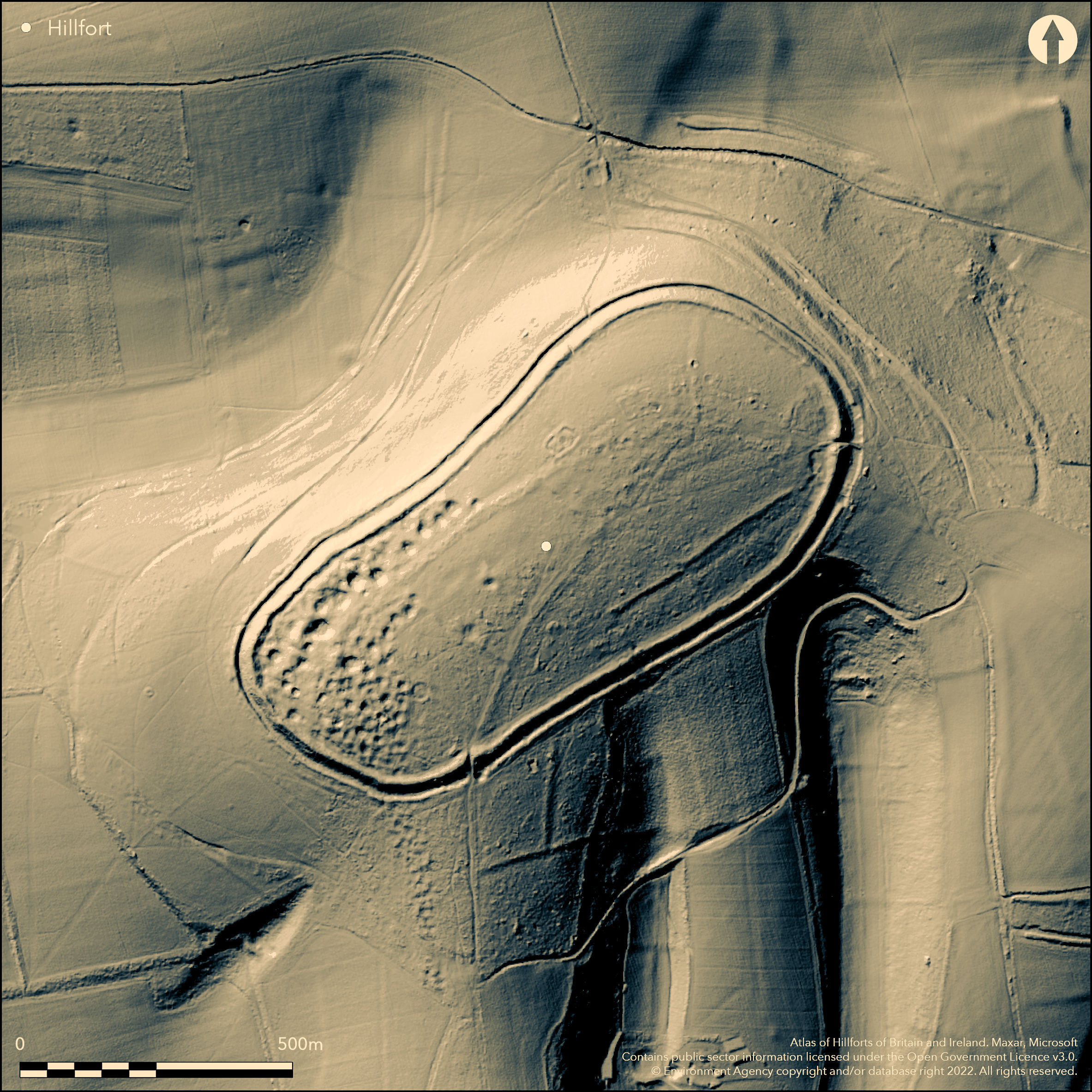
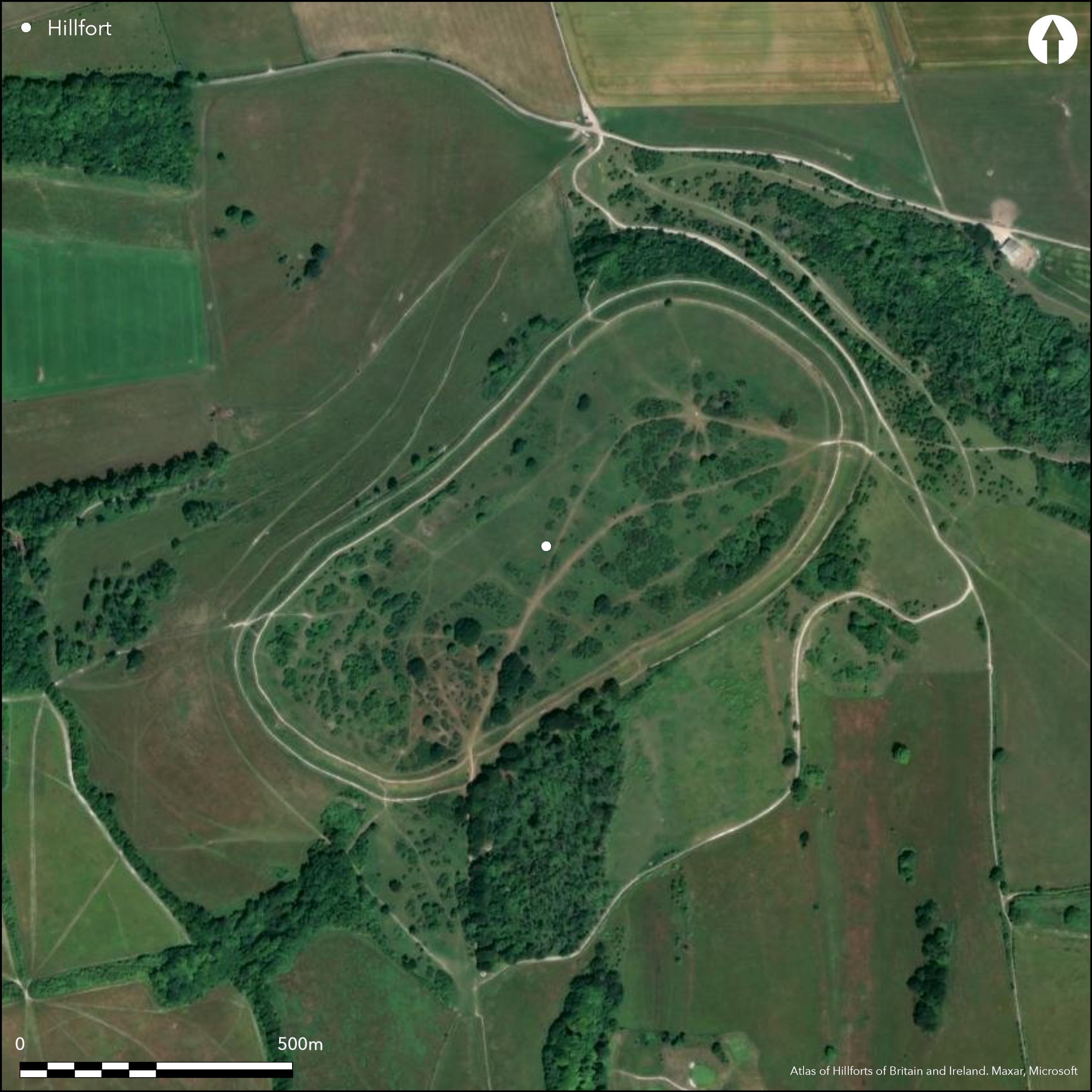
Univallate, contour hlllfort located on clay-with-flints capped chalk spur projecting from S edge of Sussex Downs, c. 3km N of Channel coast at Worthing. Location commands extensive views across coastal plain to S and downland and Weald to N. Very steep surrounding slopes to N and NW, steep elsewhere. Roughly oval aligned NE-SW with internal area c. 24ha. Defined by massive single rampart, to c. 3.9m high and c . 4m wide, with berm to deep, steeply-faced, flat-bottomed ditch to 2m deep and c. 5m wide and small counterscarp, c. 1.5m high and 3m wide. Bank best on more vulnerable SE side where slopes less steep. These have been damaged in places by modern tracks and WWII activity. Two gates, on E and S, where causeways over ditch and gaps in ramparts, measuring 4m and 1.5m wide, flanked by raised, inturned bank terminals. Excavation showed activity on hill from Neolithic, with flint mines on W side of hill top, C14 indicating from c. 3600 BC through Neolithic. These show at least 270 roughly circular hollows, with associated spoil, ranging from 3m to 36m in diameter and to 3m deep. Shafts dropped to radiating galleries. Carvings and associated artefacts found. In excess of 100 other interior features as earthworks and tracks, including lyncheted fields of first century BC and Roman cultivation, pits and small sub-rectangular buildings and associated enclosures, mainly representing Roman settlement on the hill c. AD 50-AD 450. One thought by Pitt RIvers Neolithic, but may be due to excavations. Late Roman refortification of site, with turf capping added to rampart. Much investigated since 19th century. Main excavations by Col. A.H. Lane Fox (Pitt Rivers) in later 19th century, mostly focussing on the flint mines and their relationship with the hillfort, and by R. Ross Williamson and E. Curwen in 1930, but indicated that hillfort constructed in middle Iron Age (c. 400 BC). Well-preserved National Trust site, mainly under rough grass, despite past plough damage and tree and scrub encroachment. On 1st Ed. OS map (1875).
Citizen Science: ✗
Reliability of Data: Confirmed
Reliability of Interpretation: Confirmed
X: -42657 Y: 6596650 (EPSG: 3857)
Longitude: -0.3831979997035408 Latitude: 50.8604727281584 (EPSG:4326)
Country: England; None
Current County or Unitary Authority: West Sussex
Historic County: Sussex
Current Parish/Community/Council/Townland: Findon; Worthing
Well-preserved National Trust site, despite past plough damage and tree and scrub encroachment.
| Extant | ✓ |
| Cropmark | ✗ |
| Likely Destroyed | ✗ |
Rough pasture, scattered trees and scrub. Extensive Neolithic flint mines. WWII feature.
| Woodland | ✗ |
| Commercial Forestry Plantation | ✗ |
| Parkland | ✗ |
| Pasture (Grazing) | ✓ |
| Arable | ✗ |
| Scrub/Bracken | ✗ |
| Bare Outcrop | ✗ |
| Heather/Moorland | ✗ |
| Heath | ✗ |
| Built-up | ✗ |
| Coastal Grassland | ✗ |
| Other | ✓ |
ine and important, contour hlllfort located on clay-with-flints capped chalk spur projecting from S edge of Sussex Downs, c. 3km N of Channel coast at Worthing. Location commands extensive views across coastal plain to S and downland and Weald to N. Very steep surrounding slopes to N and NW, steep elsewhere.
| Contour Fort | ✓ |
| Partial Contour Fort | ✗ |
| Promontory Fort | ✗ |
| Hillslope Fort | ✗ |
| Level Terrain Fort | ✗ |
| Marsh Fort | ✗ |
| Multiple Enclosure Fort | ✗ |
| Hilltop | ✗ |
| Coastal Promontory | ✗ |
| Inland Promontory | ✗ |
| Valley Bottom | ✗ |
| Knoll/Hillock/Outcrop | ✗ |
| Ridge | ✗ |
| Cliff/Plateau-edge/Scarp | ✗ |
| Hillslope | ✗ |
| Lowland | ✗ |
| Spur | ✓ |
Dominant Topographic Feature: Spur
| North | ✗ |
| Northeast | ✗ |
| East | ✗ |
| Southeast | ✗ |
| South | ✗ |
| Southwest | ✗ |
| West | ✗ |
| Northwest | ✗ |
| Level | ✓ |
Altitude: 183.0m
Boundary Type: Parish/Townland
Hillfort originally of probable Iron Age date, with interior cultivated in 1st century BC, with use possibly through to Roman period when interior cultivated, with late Roman settlement and refortification of site, with turf capping added to rampart AD 50-AD 450. Middle Iron Age saucepan pottery from pits.
Reliability: B - Medium
| Pre 1200BC | ✗ |
| 1200BC - 800BC | ✗ |
| 800BC - 400BC | ✗ |
| 400BC - AD50 | ✓ |
| AD50 - AD400 | ✓ |
| AD400 - AD 800 | ✓ |
| Post AD800 | ✗ |
| Unknown | ✗ |
| Pre Hillfort: | None |
| Post Hillfort: | None |
| Artefactual: | Middle Iron Age saucepan pottery from pits. |
| C14: | C14 dates of flint mine evidence indicate activity on the site from c. 3600 BC. |
| Morphology/Earthwork/Typology: | General features. |
In Aubrey's Monumenta Britannica (1665-1693). Exvcavation W. Constable 1824. Excavation A.H. Lane Fox 1867-8. On 1st Ed. OS map (1875). Excavations R. Ross Williamson and E. Curwen 1930. Full topographic survey by RCHME on behalf of National Trust 1993. Geophysical survey of NE sector of hillfort A Payne AML 2000. Watching Brief D. Dunkin Archaeology South East 2000. Measured survey English Heritage South Downs Project 2005-2011, ref. no. 890246. Measured survey Archaeology South East 2006. Geophysical survey M. Tibble Archaeology South East 2007.
| Excavation (1824): | W. Constable |
| 1st Identified Map Depiction (1875): | OS map. |
| Other (1975): | Visit by Hillfort Study Group |
| Earthwork Survey (1993): | Full topographic survey by RCHME on behalf of National Trust. |
| Geophysical Survey (2000): | Geophysical survey of NE sector of hillfort A Payne AML |
| Other (2000): | Watching Brief D. Dunkin Archaeology South East. |
| Other (2006): | Measured survey Archaeology South East. |
| Geophysical Survey (2007): | M.Tibble Archaeology South East. |
| 1st Identified Written Reference (None): | None |
| Excavation (None): | A.H. Lane Fox |
| Earthwork Survey (None): | Measured survey English Heritage South Downs Project. |
Part excavations and earthwork survey showed tracks and pits and site as settlement site during Roman period (AD 43-450). Indicated by group of, at least, 11 closely spaced, sub-rectangular depressions, representing Romano-British buildings, each measuring c. 11m by 5m and up to 1m deep, sited in E sector near E entrance. Closely associated with two rectangular enclosures up to 30m long, defined by banks 0.4m high and 2m wide. Two further sub- rectangular enclosures in N, largest surrounded by double bank measuring 50m by 38m, also possibly Roman. The excavations indicated that the hillfort ramparts were strengthened and remodelled at this time. Middle Iron Age saucepan pottery from pits. Much from flint mines excavations, including anters, picks and bone shovels, human remains and carvings.
Three stock-watering ponds.
| None | ✓ |
| Spring | ✗ |
| Stream | ✗ |
| Pool | ✓ |
| Flush | ✗ |
| Well | ✗ |
| Other | ✗ |
Flint mines show at least 270 roughly circular hollows (30 excavated), with associated spoil, ranging from 3m to 36m in diameter and to 3m deep. Shafts dropped to radiating galleries. In excess of 100 other interior features as earthworks and tracks, including lyncheted field evidence.
| No Known Features | ✗ |
| Round Stone Structures | ✗ |
| Rectangular Stone Structures | ✗ |
| Curvilinear Platforms | ✗ |
| Other Roundhouse Evidence | ✗ |
| Pits | ✗ |
| Quarry Hollows | ✗ |
| Other | ✓ |
Part excavations and earthwork survey showed tracks and pits and site as settlement site during Roman period (AD 43-450). Indicated by group of, at least, 11 closely spaced, sub-rectangular depressions, representing Romano-British buildings, each measuring c. 11m by 5m and up to 1m deep, sited in E sector near E entrance. Closely associated with two rectangular enclosures up to 30m long, defined by banks 0.4m high and 2m wide. Two further sub- rectangular enclosures in N, largest surrounded by double bank measuring 50m by 38m, also possibly Roman. The excavations indicated that the hillfort ramparts were strengthened and remodelled at this time.
| No Known Excavation | ✗ |
| Pits | ✓ |
| Postholes | ✗ |
| Roundhouses | ✗ |
| Rectangular Structures | ✓ |
| Roads/Tracks | ✓ |
| Quarry Hollows | ✗ |
| Other | ✓ |
| Nothing Found | ✗ |
No details.
| No Known Geophysics | ✗ |
| Pits | ✗ |
| Roundhouses | ✗ |
| Rectangular Structures | ✗ |
| Roads/Tracks | ✗ |
| Quarry Hollows | ✗ |
| Other | ✗ |
| Nothing Found | ✓ |
Middle Iron Age saucepan pottery from pits. Much from flint mines excavations, including anters, picks and bone shovels, human remains and carvings.
| No Known Finds | ✗ |
| Pottery | ✓ |
| Metal | ✗ |
| Metalworking | ✗ |
| Human Bones | ✓ |
| Animal Bones | ✓ |
| Lithics | ✗ |
| Environmental | ✗ |
| Other | ✓ |
None
| APs Not Checked | ✓ |
| None | ✗ |
| Roundhouses | ✗ |
| Rectangular Structures | ✗ |
| Pits | ✗ |
| Postholes | ✗ |
| Roads/Tracks | ✗ |
| Other | ✗ |
Two gates, on E and S, where causeways over ditch and gaps in ramparts, measuring 4m and 1.5m wide, flanked by raised, inturned bank terminals.
| None: | Much public access. Total modern gaps not defined. |
| 2: | None |
Guard Chambers: ✗
Chevaux de Frise: ✗
| 1. In-turned (East): | Causewayed. |
| 2. In-turned (South): | Causewayed. |
Defined by massive single rampart, to c. 3.9m high and c . 4m wide, with berm to deep, steeply-faced, flat-bottomed ditch to 2m deep and c. 5m wide and small counterscarp, c. 1.5m high and 3m wide. Bank best on more vulnerable SE side where slopes less steep.
| Area 1: | 24.0ha. |
| Total: | 24.0ha. |
Total Footprint Area: Noneha.
None
| ✗ | None |
| ✓ | None |
| NE Quadrant: | 1 |
| SE Quadrant: | 1 |
| SW Quadrant: | 1 |
| NW Quadrant: | 1 |
| Total: | 1 |
| Partial Univallate | ✗ |
| Univallate | ✓ |
| Partial Bivallate | ✗ |
| Bivallate | ✗ |
| Partial Multivallate | ✗ |
| Multivallate | ✗ |
| Unknown | ✗ |
| Partial Univallate | ✗ |
| Univallate | ✗ |
| Partial Bivallate | ✗ |
| Bivallate | ✗ |
| Partial Multivallate | ✗ |
| Multivallate | ✗ |
Good chalk banks, with berm and counterscarp to ditch.
| None | ✗ |
| Earthen Bank | ✓ |
| Stone Wall | ✗ |
| Rubble | ✗ |
| Wall-walk | ✗ |
| Evidence of Timber | ✗ |
| Vitrification | ✗ |
| Other Burning | ✗ |
| Palisade | ✗ |
| Counter Scarp Bank | ✓ |
| Berm | ✓ |
| Unfinished | ✗ |
| Other | ✗ |
Excavations showed hillfort ramparts were strengthened and remodelled in late Roman period.
| None | ✗ |
| Earthen Bank | ✓ |
| Stone Wall | ✗ |
| Murus Duplex | ✗ |
| Timber-framed | ✗ |
| Timber-laced | ✗ |
| Vitrification | ✗ |
| Other Burning | ✗ |
| Palisade | ✗ |
| Counter Scarp Bank | ✗ |
| Berm | ✗ |
| Unfinished | ✗ |
| No Known Excavation | ✗ |
| Other | ✓ |
| ✗ | None |
| ✓ | Deep, steeply-faced, flat-bottomed ditch to 2m deep and c. 5m wide. |
Number of Ditches: 1
| ✗ | None |
Carpenter E. 2008. The South Downs NMP Pilot Area 1; Worthing to The Weald, National Mapping Programme Report No 11-2008.
Constable, W. 1827. Note, Arch, 21, 546-7.
Curwen, E. and Williamson, R. Ross 1931. The date of Cissbury Camp, Ant J, 11, 14-36.
Donachie, J. D. Field, D.J. 1993. A Survey of Cissbury Ring, Worthing, West Sussex, RCHME Report.
Dunkin D. 2000. An archaeological watching brief for the replacement of two dog stiles on Cissbury Ring, Worthing, West sussex, Archaeology South East Report No 1289.
James R. 2006. Cissbury Ring, Worthing: archaeological and historic landscape survey, Archaeology South East.
Lane Fox, A.H. 1869. Further remarks on the hill forts of Sussex: being an account of excavations in the forts of Cissbury and Highdown, Arch, 42, 53-76
Payne, A.W. 2001. Cissbury Ring, Worthing, West Sussex: report on geophysical survey, April 2000, Report No 91/2001, AML.
Tibble M. 2007. A Detailed Topographical and Geophysical Survey of Land Outside the Eastern Entrance of Cissbury Ring Hillfort, Findon, Sussex, Archaeology South East.
Atlas of Hillforts:
Wikidata:
This work is licensed under CC BY-SA 4.0![]()
![]()
![]() and should be cited as:
and should be cited as:
Lock, Gary and Ralston, Ian. 2024. Atlas of Hillforts of Britain and Ireland. Available at: https://hillforts.arch.ox.ac.uk
Document Version 1.1