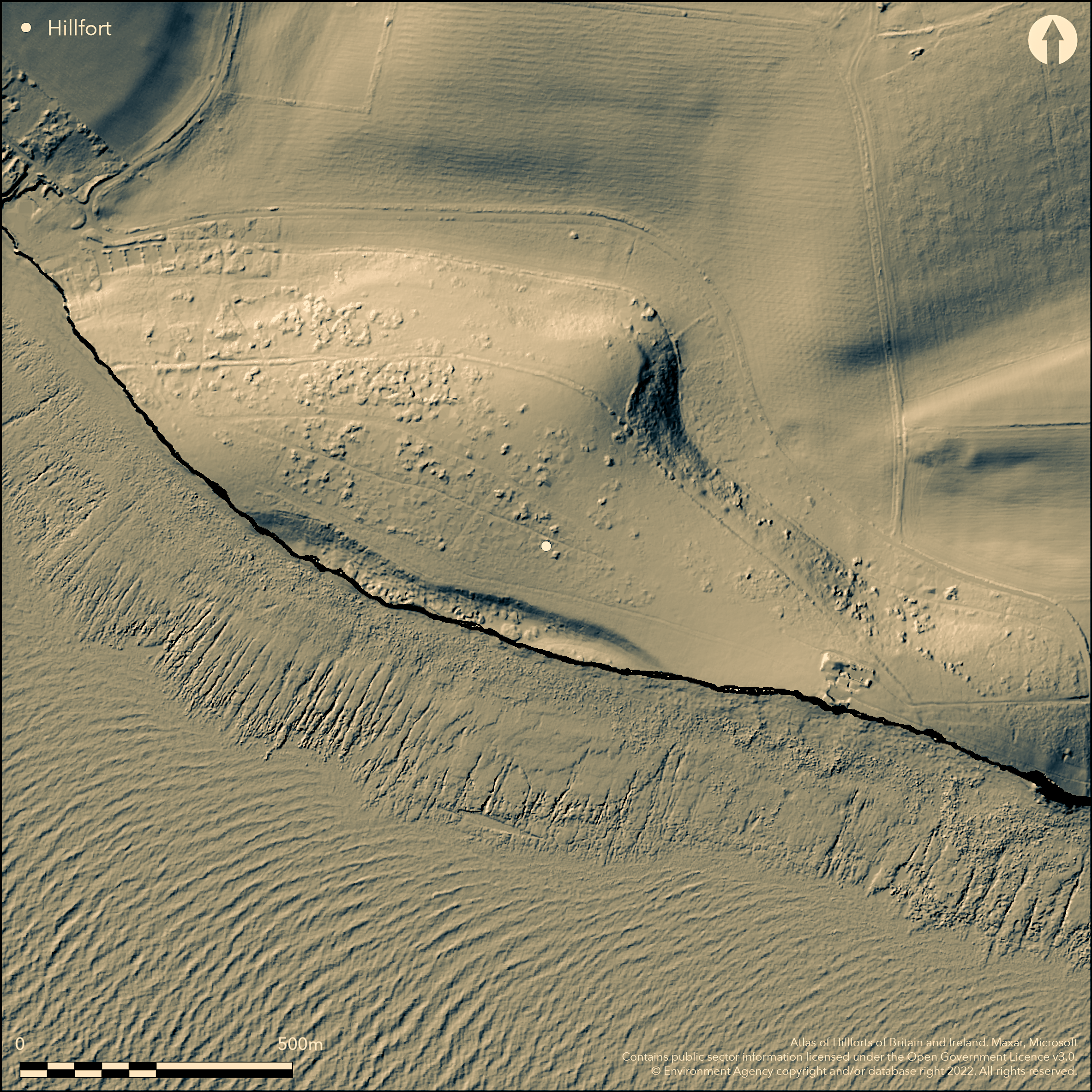
LiDAR 1m DTM Hillshade
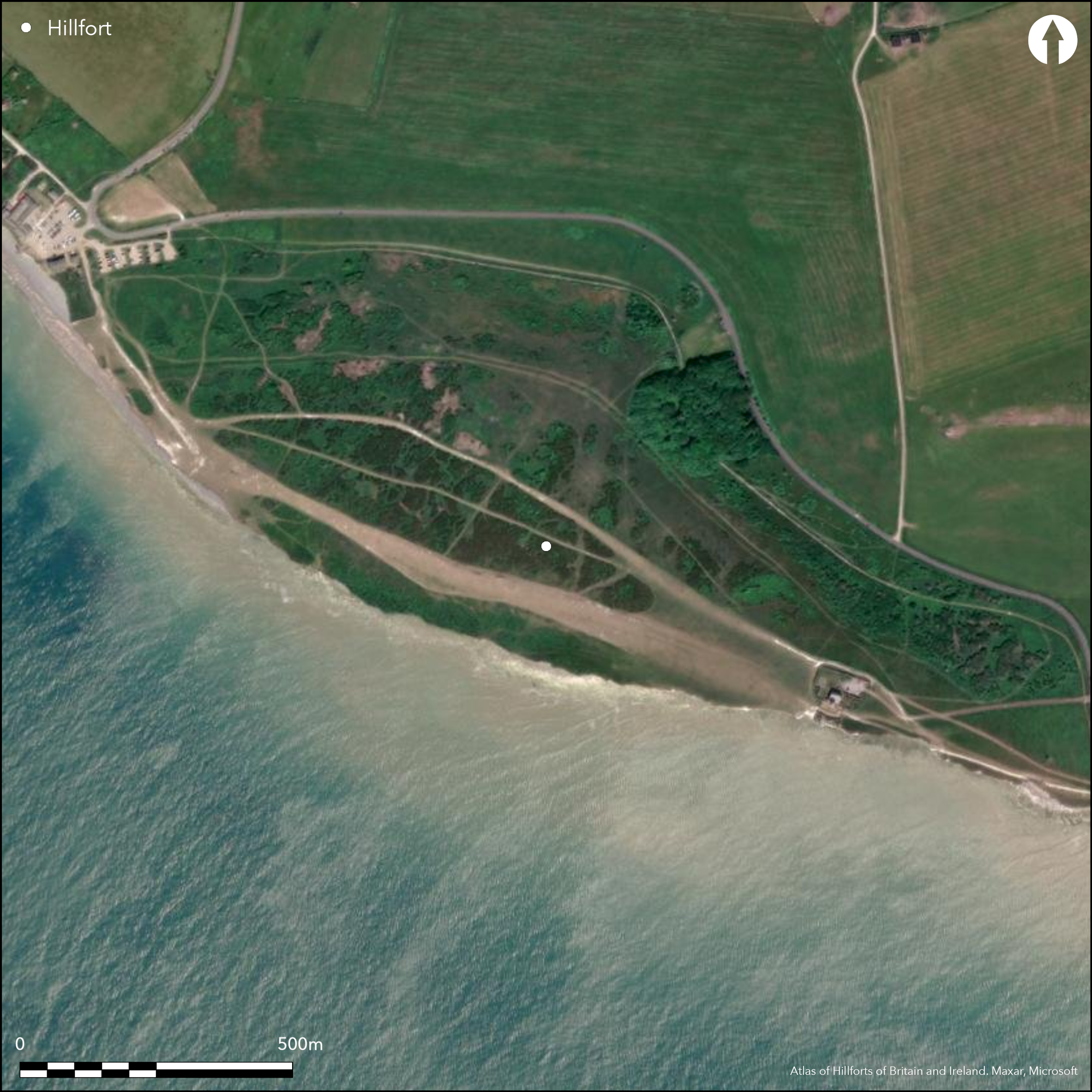
Satellite Imagery
LiDAR 1m DTM Hillshade
Satellite Imagery
Scroll left/right to view further images.
HER: East Sussex MES3054 (None)
NMR: TV 59 NE 56 (47004)
SM: 1002288
NGR: TV56019561
X: 556010 Y: 95678 (OSGB36)
Much eroded, possible, coastal promontory fort located on a hilltop next to a cliff edge of chalk headland between Beachy Head to E and Birling Gap to W. Precipitous sea cliffs on S quadrants, steep downslope, then rising moderate to strong, elsewhere. Erosion of cliffs has resulted in a great deal of site lost to sea, similar to the situation at the Flowers Barrow fort in Dorset (Atlas No 3593) and nearby Seaford Head (Atlas No 3731). Its massive size, at present c. 20+ha, and coastal location suggest similarities with the enclosure of Bindon Hill, also in Dorset (Atlas No 3582). In both, a pastoral function may be suggested. Defined by unrevetted single chalk dump bank with outer ditch, running E-W and arcing to N, for c. 1.1km. Bank varies 1.2m to 4.6m in height and ditch to 0.9m deep in places. Much degraded on E and N, where invisible in places. Possible that the bank and ditch could originally have been continuous round the top of the hill, as now destroyed on S, in which case it would not be a coastal promontory in prehistory, but originally a contour hillfort, but, there is no evidence for this and much depends on rates of erosion (Brown 2009, 185-7). Within the main enclosure, and situated on cliff edge on SW side is a small enclosed settlement of late Neolithic or Bronze Age date, now represented by L-shaped earthwork 120m by 60m and continuous pit-linked ditch of 'beaded' appearance (Russell 1996), with surviving counterscarp in places. Possibly associated with bowl barrow on N side (perhaps one of seven lost to sea). Originally there were two or possibly three overlapping rectangular enclosures, but now truncated by the cliff erosion and only the larger survives. N and E side of this enclosure part-excavated 1909 and 1968-69. This revealed sequence of successive or overlapping domestic complexes including seven occupation areas with postholes and trenches for huts, large number of pits and hearths. Beaker pottery and flint-working. In 1971, cliff fall exposed hand-cut shaft or ritual well of Iron Age or Romano-British date near to settlement but since destroyed. Large enclosure part-excavated 1975, 1979-80 and 1995, providing little securely datable material. No entrance defined, although one of modern access gaps may be original. Coastal grassland. It is possible that site is coastal enclosure rather than true hillfort, and Bradley (1971) suggests animal enclosure. On 1st Ed. OS map (1875).
Citizen Science: ✗
Reliability of Data: Confirmed
Reliability of Interpretation: Unconfirmed
X: 23342 Y: 6575377 (EPSG: 3857)
Longitude: 0.20968256891640435 Latitude: 50.73969137898196 (EPSG:4326)
Country: England; None
Current County or Unitary Authority: East Sussex
Historic County: Sussex
Current Parish/Community/Council/Townland: East Dean and Friston; Eastbourne
Much of site lost to sea on S. Bank degraded on E and N, where invisible in places. Belle Tout lighthouse on SE.
| Extant | ✓ |
| Cropmark | ✗ |
| Likely Destroyed | ✗ |
Coastal grassland. Lighthouse.
| Woodland | ✗ |
| Commercial Forestry Plantation | ✗ |
| Parkland | ✗ |
| Pasture (Grazing) | ✓ |
| Arable | ✗ |
| Scrub/Bracken | ✗ |
| Bare Outcrop | ✗ |
| Heather/Moorland | ✗ |
| Heath | ✗ |
| Built-up | ✓ |
| Coastal Grassland | ✗ |
| Other | ✗ |
Much eroded, possible, coastal promontory fort located on a hilltop next to a cliff edge of chalk headland between Beachy Head to E and Birling Gap to W. Precipitous sea cliffs on S quadrants, steep downslope, then rising moderate to strong, elsewhere. Possible that the bank and ditch could originally have been continuous round the top of the hill, as now destroyed on S, in which case it would not be a coastal promontory in prehistory, but originally a contour hillfort. Much depends on rates of erosion (Brown 2009, 185-7).
| Contour Fort | ✗ |
| Partial Contour Fort | ✗ |
| Promontory Fort | ✓ |
| Hillslope Fort | ✗ |
| Level Terrain Fort | ✗ |
| Marsh Fort | ✗ |
| Multiple Enclosure Fort | ✗ |
| Hilltop | ✗ |
| Coastal Promontory | ✓ |
| Inland Promontory | ✗ |
| Valley Bottom | ✗ |
| Knoll/Hillock/Outcrop | ✗ |
| Ridge | ✗ |
| Cliff/Plateau-edge/Scarp | ✓ |
| Hillslope | ✗ |
| Lowland | ✗ |
| Spur | ✗ |
Dominant Topographic Feature: Coastal headland.
| North | ✗ |
| Northeast | ✗ |
| East | ✗ |
| Southeast | ✗ |
| South | ✗ |
| Southwest | ✗ |
| West | ✗ |
| Northwest | ✗ |
| Level | ✓ |
Altitude: 76.0m
Boundary Type: Parish/Townland
The dating of Belle Tout is obscure. Lack of Iron Age dating evidence, but shear quantity if flints from excavations and chance finds suggest Neolithic origin. However, a land snail assemblage from Bedwin's 1979-80 excavation was possibly Roman introduction (Thomas 1982). Beaker pottery found and smaller enclosure Bronze Age or Neolithic origin. Finds from outer rampart 1995 excavation suggest late Neolithic origin.
Reliability: B - Medium
| Pre 1200BC | ✓ |
| 1200BC - 800BC | ✓ |
| 800BC - 400BC | ✗ |
| 400BC - AD50 | ✗ |
| AD50 - AD400 | ✗ |
| AD400 - AD 800 | ✗ |
| Post AD800 | ✗ |
| Unknown | ✗ |
| Pre Hillfort: | None |
| Post Hillfort: | None |
| Artefactual: | Beaker pottery. Finds from outer rampart 1995 excavation suggest late Neolithic origin. |
First recorded in 1812. Survey by Lane Fox 1867. On 1st Ed. OS map (1875). Excavation H.S. Toms 1909. Excavation R. Bradley 1968-9. Excavation P.L. Drewett 1975. Excavation O. Bedwin 1979-80. Geophysical survey M. Russell Bournemouth University 1995. Excavation M. Russell Bournemouth University 1995. Measured survey RCHME Industry and Enclosure in the Neolithic Project 1996. Measured survey English Heritage South Downs Project 2005-2011. LiDar survey Environment Agency 2008.
| Other (1867): | Lane Fox survey. |
| 1st Identified Map Depiction (1875): | OS map. |
| Excavation (1909): | H.S.Toms. |
| Excavation (1975): | P.L. Drewett |
| Excavation (1995): | Excavation M. Russell Bournemouth University 1995. |
| Earthwork Survey (1996): | Measured survey RCHME Industry and Enclosure in the Neolithic Project. |
| LiDAR Survey (2008): | Environment Agency |
| Excavation (None): | R. Bradley. |
| Excavation (None): | O. Bedwin. |
| 1st Identified Written Reference (None): | No details. |
| Earthwork Survey (None): | Measured survey Englsh heritage South Downs Project. |
N and E side of small enclosure part-excavated 1909 and 1968-69. Revealed sequence of successive or overlapping domestic complexes including seven occupation areas with postholes and trenches for huts, large number of pits and hearths. Beaker pottery and flint-working. In 1971, cliff fall exposed hand-cut shaft or ritual well of Iron Age or Romano-British date near to settlement but since been destroyed. 1995 geophysical survey to assess nature of archaeological deposits at cliff edge. Outcome not specified
None
| None | ✓ |
| Spring | ✗ |
| Stream | ✗ |
| Pool | ✗ |
| Flush | ✗ |
| Well | ✗ |
| Other | ✗ |
None
| No Known Features | ✓ |
| Round Stone Structures | ✗ |
| Rectangular Stone Structures | ✗ |
| Curvilinear Platforms | ✗ |
| Other Roundhouse Evidence | ✗ |
| Pits | ✗ |
| Quarry Hollows | ✗ |
| Other | ✗ |
N and E side of small enclosure part-excavated 1909 and 1968-69. Revealed sequence of successive or overlapping domestic complexes including seven occupation areas with postholes and trenches for huts, large number of pits and hearths. In 1971, cliff fall exposed hand-cut shaft or ritual well of Iron Age or Romano-British date near to settlement, but since destroyed.
| No Known Excavation | ✗ |
| Pits | ✓ |
| Postholes | ✓ |
| Roundhouses | ✓ |
| Rectangular Structures | ✗ |
| Roads/Tracks | ✗ |
| Quarry Hollows | ✗ |
| Other | ✓ |
| Nothing Found | ✗ |
1995 geophysical survey to assess nature of archaeological deposits at cliff edge. Outcome not specified.
| No Known Geophysics | ✗ |
| Pits | ✗ |
| Roundhouses | ✗ |
| Rectangular Structures | ✗ |
| Roads/Tracks | ✗ |
| Quarry Hollows | ✗ |
| Other | ✓ |
| Nothing Found | ✗ |
Beaker pottery and flint-working from small enclosure.
| No Known Finds | ✗ |
| Pottery | ✓ |
| Metal | ✗ |
| Metalworking | ✗ |
| Human Bones | ✗ |
| Animal Bones | ✗ |
| Lithics | ✓ |
| Environmental | ✗ |
| Other | ✗ |
None
| APs Not Checked | ✓ |
| None | ✗ |
| Roundhouses | ✗ |
| Rectangular Structures | ✗ |
| Pits | ✗ |
| Postholes | ✗ |
| Roads/Tracks | ✗ |
| Other | ✗ |
None entrance defined, although one of modern access gaps may be original.
| 0: | Total gaps not defined. |
| 2: | One of modern access gaps may be original. |
Guard Chambers: ✗
Chevaux de Frise: ✗
Defined by unrevetted single bank with outer ditch, running E-W and arcing to N, for c. 1.1km. Bank varies 1.2m to 4.6m in height and ditch to 0.9m deep in places. Much degraded on E and N, where invisible in places.
| Area 1: | 20.0ha. |
| Total: | 20.0ha. |
Total Footprint Area: Noneha.
None
| ✗ | None |
| ✗ | None |
| NE Quadrant: | 1 |
| SE Quadrant: | 0 |
| SW Quadrant: | 0 |
| NW Quadrant: | 1 |
| Total: | 1 |
| Partial Univallate | ✓ |
| Univallate | ✗ |
| Partial Bivallate | ✗ |
| Bivallate | ✗ |
| Partial Multivallate | ✗ |
| Multivallate | ✗ |
| Unknown | ✗ |
| Partial Univallate | ✗ |
| Univallate | ✗ |
| Partial Bivallate | ✗ |
| Bivallate | ✗ |
| Partial Multivallate | ✗ |
| Multivallate | ✗ |
Counterscarp survives in places.
| None | ✗ |
| Earthen Bank | ✓ |
| Stone Wall | ✗ |
| Rubble | ✗ |
| Wall-walk | ✗ |
| Evidence of Timber | ✗ |
| Vitrification | ✗ |
| Other Burning | ✗ |
| Palisade | ✗ |
| Counter Scarp Bank | ✓ |
| Berm | ✗ |
| Unfinished | ✗ |
| Other | ✗ |
Bedwin's excavations 1979-80 found bank simple unrevetted chalk dump. 1995 single trench cut across main outer circuit. Sample trenches excavated across smaller rectangular (Bronze Age) enclosure within.
| None | ✗ |
| Earthen Bank | ✓ |
| Stone Wall | ✗ |
| Murus Duplex | ✗ |
| Timber-framed | ✗ |
| Timber-laced | ✗ |
| Vitrification | ✗ |
| Other Burning | ✗ |
| Palisade | ✗ |
| Counter Scarp Bank | ✗ |
| Berm | ✗ |
| Unfinished | ✗ |
| No Known Excavation | ✗ |
| Other | ✗ |
| ✗ | None |
| ✓ | None |
Number of Ditches: 1
| ✗ | None |
Bedwin, O. 1982a Excavations at Belle Tout, Eastbourne 1979-1980, In ed P. Drewett, The Archaeology of Bullock Down, Eastbourne: The Development of a Landscape. Sussex Archaeol Collect. Monograph 1,90-95.
Bradley, R. 1970. The Excavation of a Beaker Settlement at Belle Tout, East Sussex. PPS, 36, 312-379.
Bradley, R. 1971 An Iron Age Promontory Fort at Belle Tout. Sussex Archaeol Collect. 109, 8-19.
Bradley, R. 1982 Belle Tout - Revision and Reassessment. In ed P. Drewett,The Archaeology of Bullock Down, Eastbourne: The Development of a Landscape. Sussex Archaeol Collect. Monograph 1, 62-71.
Brown, I. 2009. Beacons in the landscape. The hillforts of England and Wales, Oxford: Windgather Press/Oxbow Books.
Drewett, P. 1975. A Section Through the Iron Age Promontory Fort at Belle Tout, Sussex Archaeol Collect. 113, 184-6.
Drewett, P. 1979. A Section Through the Pre-Roman Iron Age Enclosure at Belle Tout, Bull Inst Archaeol London, 16, 41.
Holgate, R. 1986 Prehistoric Sites Threatened by Coastal Erosion Between Seaford Head and Beachy Head, East Sussex, Sussex Archaeol Collect.124, 243-4.
Lane-Fox, A. 1869. An Examination into the Character and Probable Origin of the Hill Forts of Sussex, Arch, 42, 27-52.
Russell, M. 1996. Belle Tout, Unpublished Excavation Report, Bournemouth University.
Stevens, L. 1979. A Chalk Cut Shaft at Belle Tout, Eastdean, SAC,117, 260.
Stevens, L. 1986 Belle Tout - A Third Excavation? Sussex Archaeological Newsletter 49, 494.
Thomas, K. 1982 A Note on the Environmental and Chronological Implications of the Molluscs from the Enclosure at Belle Tout, In ed P. Drewett, The Archaeology of Bullock Down, Eastbourne: The Development of a Landscape. Sussex Archaeol Collect. Monograph 1,14-5.
Atlas of Hillforts:
Wikidata:
This work is licensed under CC BY-SA 4.0

 and should be cited as:
Lock, Gary and Ralston, Ian. 2024. Atlas of Hillforts of Britain and Ireland. Available at: https://hillforts.arch.ox.ac.uk
Document Version 1.1