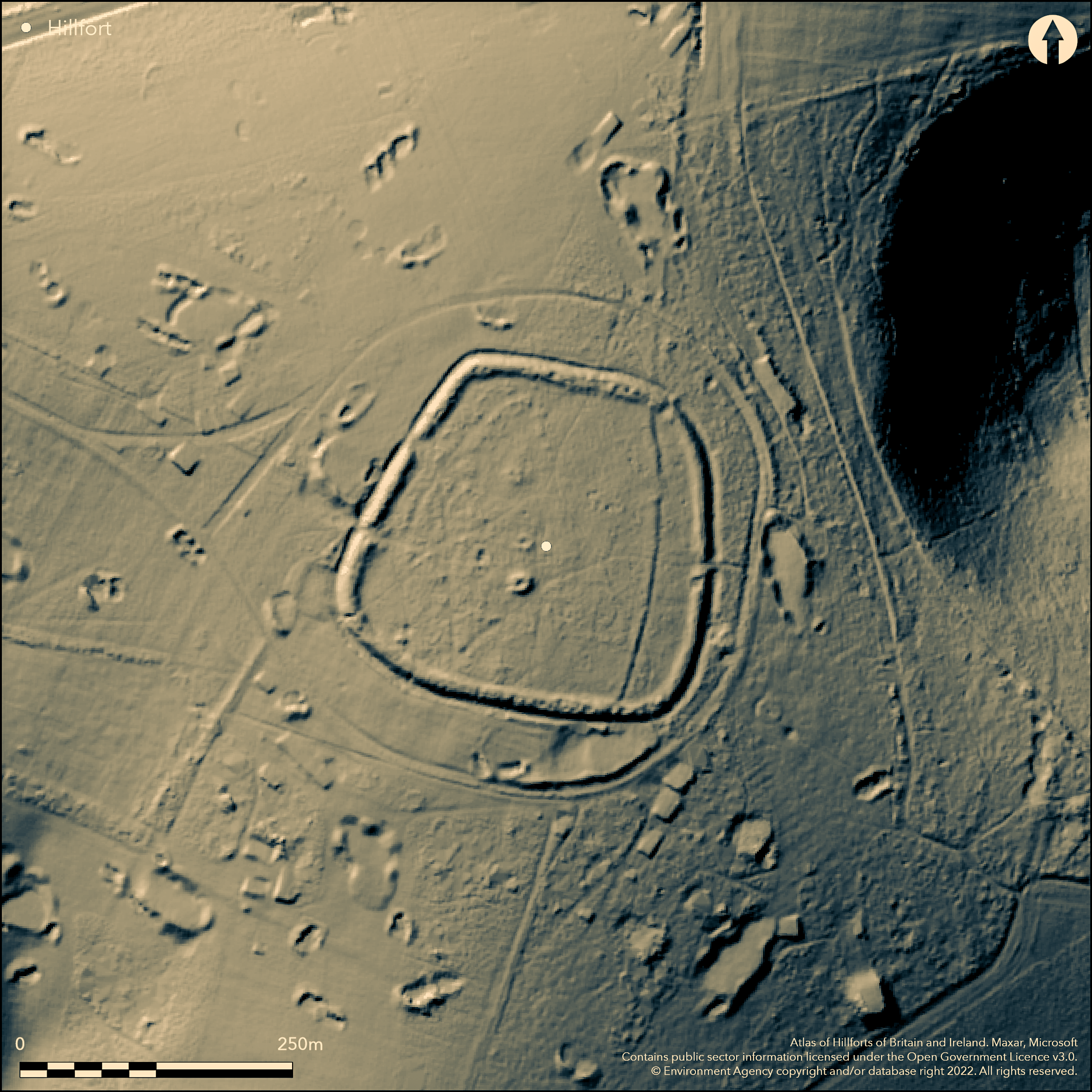
LiDAR 1m DTM Hillshade
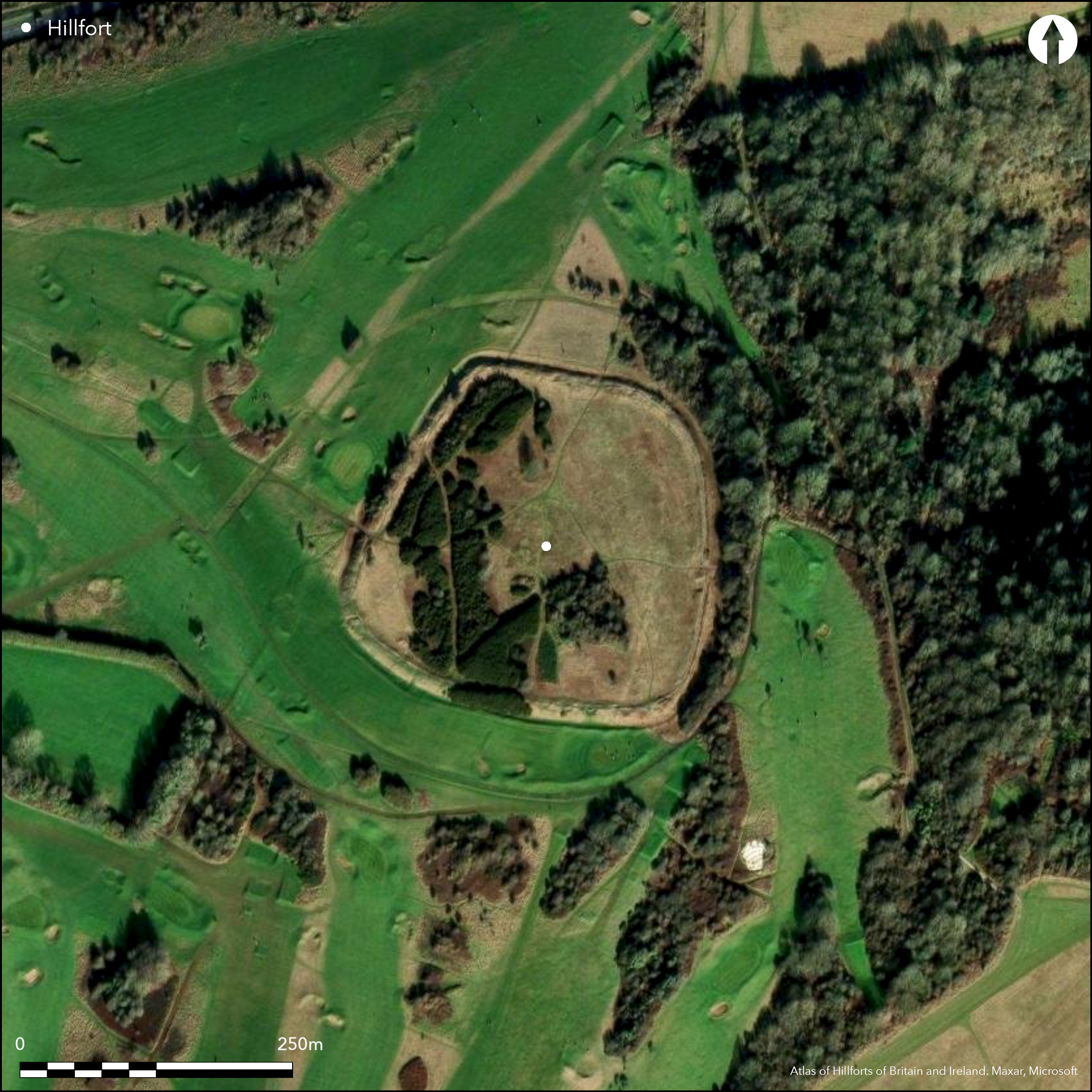
Satellite Imagery
LiDAR 1m DTM Hillshade
Satellite Imagery
Scroll left/right to view further images.
HER: East Sussex MES311 (None)
NMR: TQ 30 NW 12 (401975)
SM: 1014526
NGR: TQ32210787
X: 532211 Y: 107883 (OSGB36)
Univallate partial contour hillfort located on clay-capped, chalk hill on NE edge of modern Brighton. Extensive views to sea to S. Moderate or moderate to strong slopes to N, SE, S and W and above very steep and wooded narrow dry valley cutting into hill to NE and E. Sloping to SE and cutting across contours on NW. Sub-square in plan enclosing c. 4.5ha. Excavations by Toms 1908, Curwen 1931 and Holmes 1967-69 dated hillfort to early 6th century BC, and preceded by late Bronze Age or early Iron Age enclosure and later by Romano-Celtic temple on site. Main hillfort rampart c. 10m wide to c. 1.5m high, separated by berm of c. 3m from a partly infilled, outer ditch c. 4m wide to c. 1m deep, with slight counterscarp on S. Profile of ditch disturbed by later landscaping of Hollingbury modern golf course. Excavations revealed that bank was originally box construction, or earth and chalk rubble wall reinforced with timbers and revetted with turves, up to 2m high. Traces of the earlier enclosure survive as low N-S, slightly curving bank c. 25m within and parallel to E rampart of main fort, flanked to E by infilled ditch c. 3m wide. This earlier enclosure suggested as hedged animal pound, but no direct evidence for this. Inturned entrance situated on W side near SW corner. Gap in W rampart near NW corner modern disturbance by army training activities during WWI and WW II. 1967-69 excavation found five roundhouses of early 6th century BC in SW corner; diameters c. 4.25m and c.12.25m, Group of circular pits, with possible water storage and resistivity survey of interior 1998 identified number of possible pit features. Fragments of a triangular loomweight and quern. Reuse in Roman period with pottery and remains of palisaded enclosure with wooden gateway, interpreted as the temenos, or sacred outer precinct, of Romano-Celtic temple, and located c. 50m within earlier, E hillfort rampart. At same time second entrance constructed through E hillfort defences, immediately opposite the gate of smaller, palisaded enclosure, both linked by metalled track. This later enclosure interpreted as the temenos, or sacred outer precinct, of Romano-Celtic temple. Concrete posts inserted into postholes of E hillfort gateway in 1967-1969 excavation to indicated detail. Three Bronze Age bowl barrows form linear group near centre of hillfort, one possibly used as medieval /post-medieval beacon base. On 1st Ed. OS map (1874).
Citizen Science: ✗
Reliability of Data: Confirmed
Reliability of Interpretation: Confirmed
X: -13694 Y: 6595736 (EPSG: 3857)
Longitude: -0.12301093997483217 Latitude: 50.855291238854086 (EPSG:4326)
Country: England
Current County or Unitary Authority: East Sussex
Historic County: Sussex
Current Parish/Community/Council/Townland: Brighton
Entrance part mutilated. Hollingbury golf course encroaches on N. Modern steps.
| Extant | ✓ |
| Cropmark | ✗ |
| Likely Destroyed | ✗ |
Rough pasture and scrub. Golf course encroachment.
| Woodland | ✗ |
| Commercial Forestry Plantation | ✗ |
| Parkland | ✗ |
| Pasture (Grazing) | ✓ |
| Arable | ✗ |
| Scrub/Bracken | ✓ |
| Bare Outcrop | ✗ |
| Heather/Moorland | ✗ |
| Heath | ✗ |
| Built-up | ✗ |
| Coastal Grassland | ✗ |
| Other | ✓ |
Univallate partial contour hillfort located clay-capped, chalk hill on NE edge of modern Brighton. hill top. Extensive views to sea to S. Moderate or moderate to strong slopes to N, SE, S and W and above very steep and wooded narrow dry valley cutting into hill to NE and E. Sloping to SE and cutting across contours on NW.
| Contour Fort | ✗ |
| Partial Contour Fort | ✓ |
| Promontory Fort | ✗ |
| Hillslope Fort | ✗ |
| Level Terrain Fort | ✗ |
| Marsh Fort | ✗ |
| Multiple Enclosure Fort | ✗ |
| Hilltop | ✓ |
| Coastal Promontory | ✗ |
| Inland Promontory | ✗ |
| Valley Bottom | ✗ |
| Knoll/Hillock/Outcrop | ✗ |
| Ridge | ✗ |
| Cliff/Plateau-edge/Scarp | ✗ |
| Hillslope | ✗ |
| Lowland | ✗ |
| Spur | ✗ |
Dominant Topographic Feature: Hill top
| North | ✗ |
| Northeast | ✗ |
| East | ✗ |
| Southeast | ✓ |
| South | ✗ |
| Southwest | ✗ |
| West | ✗ |
| Northwest | ✗ |
| Level | ✗ |
Altitude: 178.0m
N/A
Dated by excavated pottery. Earlier enclosure (LBA/EIA), Roman re-use and possible Romano-Celtic temple on site.
Reliability: B - Medium
| Pre 1200BC | ✗ |
| 1200BC - 800BC | ✗ |
| 800BC - 400BC | ✓ |
| 400BC - AD50 | ✓ |
| AD50 - AD400 | ✓ |
| AD400 - AD 800 | ✗ |
| Post AD800 | ✗ |
| Unknown | ✗ |
| Pre Hillfort: | None |
| Post Hillfort: | None |
| Artefactual: | Pottery dating. |
On 1st Ed. OS map (1874). Excavation H.S. Toms 1908. Excavation E. Curwen 1931, Holmes 1967-69. Geophysical survey Brighton and Hove Archaeological Society 1998.
| 1st Identified Map Depiction (1874): | OS map. |
| Excavation (1908): | H.S. Toms. |
| Excavation (1931): | E. Curwen. |
| Geophysical Survey (1998): | Survey Brighton and Hove Archaeological Society. |
| Excavation (None): | Holmes |
1967-69 excavation found five roundhouses of early 6th century BC in SW corner. Group of circular pits, with possible water storage. Remains of palisaded enclosure with wooden gateway, interpreted as the temenos, or sacred outer precinct, of Romano-Celtic temple, and located c. 50m within earlier, E hillfort rampart. At same time second entrance constructed through E hillfort defences, immediately opposite the gate of smaller, palisaded enclosure, both linked by metalled track. This later enclosure interpreted as the temenos, or sacred outer precinct, of Romano-Celtic temple. Fragments of a triangular loomweight and quern. Roman pottery.
Group of circular pits, with possible water storage.
| None | ✗ |
| Spring | ✗ |
| Stream | ✗ |
| Pool | ✗ |
| Flush | ✗ |
| Well | ✗ |
| Other | ✓ |
None
| No Known Features | ✓ |
| Round Stone Structures | ✗ |
| Rectangular Stone Structures | ✗ |
| Curvilinear Platforms | ✗ |
| Other Roundhouse Evidence | ✗ |
| Pits | ✗ |
| Quarry Hollows | ✗ |
| Other | ✗ |
1967-69 excavation found five roundhouses of early sixth century BC in SW corner. Group of circular pits, with possible water storage. Remains of palisaded enclosure with wooden gateway, interpreted as the temenos, or sacred outer precinct, of Romano-Celtic temple (defined as 'other') and located c. 50m within earlier, E hillfort rampart. At same time second entrance constructed through E hillfort defences, immediately opposite the gate of the smaller, palisaded enclosure, both linked by metalled track.
| No Known Excavation | ✗ |
| Pits | ✓ |
| Postholes | ✓ |
| Roundhouses | ✓ |
| Rectangular Structures | ✗ |
| Roads/Tracks | ✓ |
| Quarry Hollows | ✗ |
| Other | ✓ |
| Nothing Found | ✗ |
Resistivity survey of interior 1998 identified number of possible pit features, but no roundhouses.
| No Known Geophysics | ✗ |
| Pits | ✓ |
| Roundhouses | ✗ |
| Rectangular Structures | ✗ |
| Roads/Tracks | ✗ |
| Quarry Hollows | ✗ |
| Other | ✗ |
| Nothing Found | ✗ |
Fragments of a triangular loomweight and quern. Roman pottery.
| No Known Finds | ✗ |
| Pottery | ✓ |
| Metal | ✗ |
| Metalworking | ✗ |
| Human Bones | ✗ |
| Animal Bones | ✗ |
| Lithics | ✓ |
| Environmental | ✗ |
| Other | ✓ |
None
| APs Not Checked | ✓ |
| None | ✗ |
| Roundhouses | ✗ |
| Rectangular Structures | ✗ |
| Pits | ✗ |
| Postholes | ✗ |
| Roads/Tracks | ✗ |
| Other | ✗ |
Mutilated inturned entrance situated on W side near SW corner. Gap in W rampart near NW corner modern disturbance by army training activities during WWI and WW II. Later in Roman period, second entrance constructed through E hillfort defences, immediately opposite the gate of smaller, palisaded enclosure interpreted as tenemos of Romano-Celtic temple, both linked by metalled track.
| 3: | Gap near NW corner modern. |
| 2: | None |
Guard Chambers: ✗
Chevaux de Frise: ✗
| 1. In-turned (South west): | Mutilated. |
| 2. Simple Gap (East): | Constructed in Roman period. |
Defences of main hillfort of rampart c. 10m wide to c. 1.5m high, separated by berm of c. 3m from a partly infilled, outer ditch c. 4m wide to c. 1m deep, with slight counterscarp on S. Profile of ditch disturbed by later landscaping of Hollingbury modern golf course. Excavations revealed that bank was originally box construction, or earth and chalk rubble wall reinforced with timbers and revetted with turves, up to 2m high. Traces of the earlier enclosure survive as low N-S, slightly curving bank c. 25m within and parallel to E rampart of main fort, flanked to E by infilled ditch c. 3m wide.
| Area 1: | 4.5ha. |
| Total: | 4.5ha. |
Total Footprint Area: Noneha.
None
| ✗ | None |
| ✓ | None |
| NE Quadrant: | 1 |
| SE Quadrant: | 1 |
| SW Quadrant: | 1 |
| NW Quadrant: | 1 |
| Total: | 1 |
| Partial Univallate | ✗ |
| Univallate | ✓ |
| Partial Bivallate | ✗ |
| Bivallate | ✗ |
| Partial Multivallate | ✗ |
| Multivallate | ✗ |
| Unknown | ✗ |
| Partial Univallate | ✗ |
| Univallate | ✗ |
| Partial Bivallate | ✗ |
| Bivallate | ✗ |
| Partial Multivallate | ✗ |
| Multivallate | ✗ |
None
| None | ✗ |
| Earthen Bank | ✓ |
| Stone Wall | ✗ |
| Rubble | ✗ |
| Wall-walk | ✗ |
| Evidence of Timber | ✗ |
| Vitrification | ✗ |
| Other Burning | ✗ |
| Palisade | ✗ |
| Counter Scarp Bank | ✓ |
| Berm | ✗ |
| Unfinished | ✗ |
| Other | ✗ |
Excavations revealed that bank was originally box construction, or earth and chalk rubble wall reinforced with timbers and revetted with turves, up to 2m high. Berm between rampart and ditch.
| None | ✗ |
| Earthen Bank | ✓ |
| Stone Wall | ✗ |
| Murus Duplex | ✗ |
| Timber-framed | ✓ |
| Timber-laced | ✗ |
| Vitrification | ✗ |
| Other Burning | ✗ |
| Palisade | ✓ |
| Counter Scarp Bank | ✗ |
| Berm | ✓ |
| Unfinished | ✗ |
| No Known Excavation | ✗ |
| Other | ✓ |
| ✗ | None |
| ✓ | None |
Number of Ditches: 1
| ✗ | None |
Curwen, E. C. 1932. Excavations at Hollingbury Camp, Sussex, Antiq J, 12, 1-16.
Funnel J. 1998. A resistivity survey at Hollingbury hillfort, Unpublished monograph.
Hamilton, S. and Manley, J.1997. Points of view. Prominent enclosures in 1st millennium Sussex, Sussex Archaeol Coll, 135, 93-112.
Hamilton, S. and Manley, J. 2001. Hillforts, monumentality and place: a chronological and topographic review of first millennium BC hillforts of southeast England, European J Archaeol, 4.1, 7-42.
Holden, E.W. 1966. Stoke Clump, Hollingbury and the early pre-Roman Iron Age in Sussex, Sussex Archaeol Collect. 104, 109-20.
Holmes, J.1984. Excavations at Hollingbury Camp, Sussex, 1967-9, Sussex Archaeol Collect. 122, 29-53.
Toms, H.S. 1914. Brighton and Hove Archaeological Society annual report, 9-19.
Atlas of Hillforts:
Wikidata:
This work is licensed under CC BY-SA 4.0

 and should be cited as:
Lock, Gary and Ralston, Ian. 2024. Atlas of Hillforts of Britain and Ireland. Available at: https://hillforts.arch.ox.ac.uk
Document Version 1.1