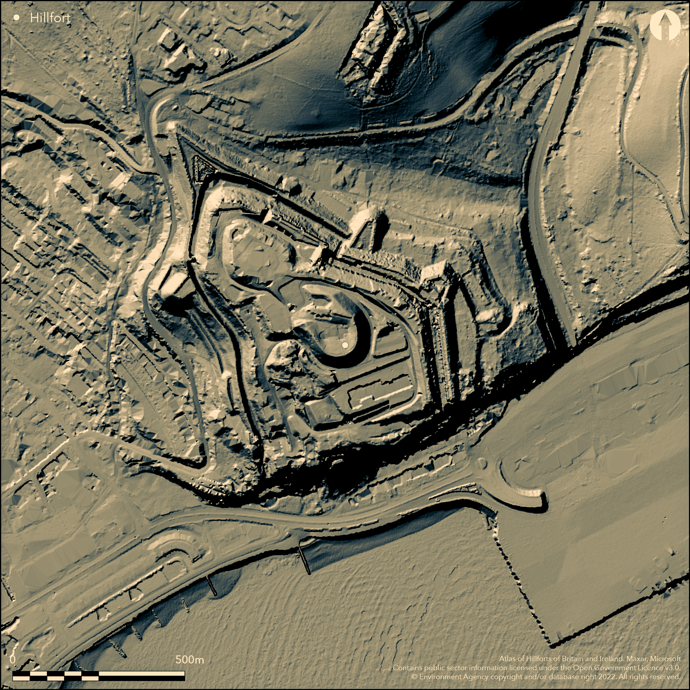
LiDAR 1m DTM Hillshade
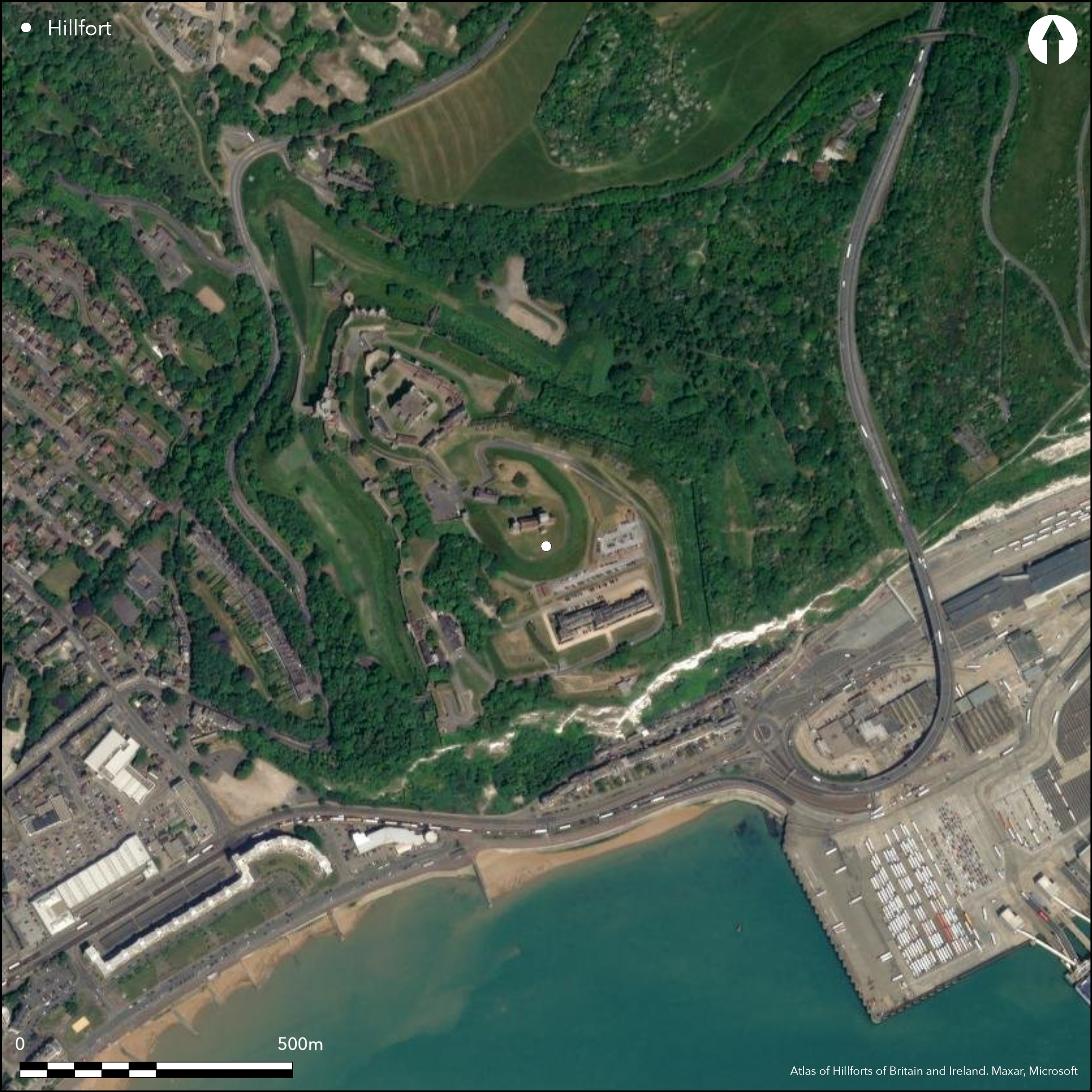
Satellite Imagery
LiDAR 1m DTM Hillshade
Satellite Imagery
Scroll left/right to view further images.
HER: Kent MKE17899 (None)
NMR: TR 34 SW 99 (468006)
SM: 1019075
NGR: TR 32641 41807
X: 632641 Y: 141807 (OSGB36)
Occupying a chalk promontory overlooking the River Dour, a possible univallate hillfort located on the site of Dover Castle. It is believed to have been triangular in form measuring 300m N-S by 200m transversely following the contours of the hill and naturally defined in the S by a steep cliff. The irregular outline of the castle, which fails to comply with military architecture of the period, is believed to have been influenced by the form of the hillfort (Clark 1884; Colvin 1959). A possible in-turned entrance lies in the NE where there is an overlapping bank and ditch. A Roman lighthouse, Saxon settlement and a church lie within the interior. Iron Age pits were identified during excavations adjacent to the church. Nothing further is known. Scheduled
Citizen Science: ✗
Reliability of Data: Unconfirmed
Reliability of Interpretation: Irreconciled issues
X: 147337 Y: 6644003 (EPSG: 3857)
Longitude: 1.32354869259699 Latitude: 51.12820227226768 (EPSG:4326)
Country: England
Current County or Unitary Authority: Kent
Historic County: Kent
Current Parish/Community/Council/Townland: Dover
None
| Extant | ✓ |
| Cropmark | ✗ |
| Likely Destroyed | ✓ |
Occupied by the castle and later buildings
| Woodland | ✗ |
| Commercial Forestry Plantation | ✗ |
| Parkland | ✗ |
| Pasture (Grazing) | ✗ |
| Arable | ✗ |
| Scrub/Bracken | ✗ |
| Bare Outcrop | ✗ |
| Heather/Moorland | ✗ |
| Heath | ✗ |
| Built-up | ✓ |
| Coastal Grassland | ✗ |
| Other | ✗ |
A possible former contour fort occupying a chalk promontory at 137m OD. The ground slopes away from the interior in all directions
| Contour Fort | ✓ |
| Partial Contour Fort | ✗ |
| Promontory Fort | ✗ |
| Hillslope Fort | ✗ |
| Level Terrain Fort | ✗ |
| Marsh Fort | ✗ |
| Multiple Enclosure Fort | ✗ |
| Hilltop | ✓ |
| Coastal Promontory | ✗ |
| Inland Promontory | ✓ |
| Valley Bottom | ✗ |
| Knoll/Hillock/Outcrop | ✗ |
| Ridge | ✗ |
| Cliff/Plateau-edge/Scarp | ✗ |
| Hillslope | ✗ |
| Lowland | ✗ |
| Spur | ✗ |
Dominant Topographic Feature: Chalk Promontory
| North | ✗ |
| Northeast | ✗ |
| East | ✗ |
| Southeast | ✗ |
| South | ✗ |
| Southwest | ✗ |
| West | ✗ |
| Northwest | ✗ |
| Level | ✓ |
Altitude: 137.0m
N/A
The site is undated
Reliability: D - None
| Pre 1200BC | ✗ |
| 1200BC - 800BC | ✗ |
| 800BC - 400BC | ✗ |
| 400BC - AD50 | ✗ |
| AD50 - AD400 | ✗ |
| AD400 - AD 800 | ✗ |
| Post AD800 | ✗ |
| Unknown | ✓ |
| Pre Hillfort: | None |
| Post Hillfort: | Roman lighthouse, Saxon settlement, castle and a church lie within the interior |
Proposed by Clark (1884) as the site of a 'camp'. No investigation has taken place, but a series of Iron Age pits discovered near to the church. The possible hillfort is included in the scheduling of the Castle and other remains
| 1st Identified Written Reference (1884): | None |
No internal features are known, Iron Age pits excavated in interior
None
| None | ✓ |
| Spring | ✗ |
| Stream | ✗ |
| Pool | ✗ |
| Flush | ✗ |
| Well | ✗ |
| Other | ✗ |
None
| No Known Features | ✓ |
| Round Stone Structures | ✗ |
| Rectangular Stone Structures | ✗ |
| Curvilinear Platforms | ✗ |
| Other Roundhouse Evidence | ✗ |
| Pits | ✗ |
| Quarry Hollows | ✗ |
| Other | ✗ |
It is uncertain if the pits are associated with the hillfort
| No Known Excavation | ✗ |
| Pits | ✓ |
| Postholes | ✗ |
| Roundhouses | ✗ |
| Rectangular Structures | ✗ |
| Roads/Tracks | ✗ |
| Quarry Hollows | ✗ |
| Other | ✗ |
| Nothing Found | ✗ |
None
| No Known Geophysics | ✓ |
| Pits | ✗ |
| Roundhouses | ✗ |
| Rectangular Structures | ✗ |
| Roads/Tracks | ✗ |
| Quarry Hollows | ✗ |
| Other | ✗ |
| Nothing Found | ✗ |
None
| No Known Finds | ✓ |
| Pottery | ✗ |
| Metal | ✗ |
| Metalworking | ✗ |
| Human Bones | ✗ |
| Animal Bones | ✗ |
| Lithics | ✗ |
| Environmental | ✗ |
| Other | ✗ |
None
| APs Not Checked | ✓ |
| None | ✗ |
| Roundhouses | ✗ |
| Rectangular Structures | ✗ |
| Pits | ✗ |
| Postholes | ✗ |
| Roads/Tracks | ✗ |
| Other | ✗ |
Possible in-turned entrance lies in the NE where there is an overlapping bank and ditch
| 1: | None |
| 2: | None |
Guard Chambers: ✗
Chevaux de Frise: ✗
| 1. In-turned (North east): | None |
Possibly univallate, triangular in form measuring 300m N-S by 200m transversely following the contours of the hill
| Area 1: | 6.0ha. |
| Total: | 6.0ha. |
Total Footprint Area: Noneha.
None
| ✗ | None |
| ✗ | Unknown |
| NE Quadrant: | None |
| SE Quadrant: | None |
| SW Quadrant: | None |
| NW Quadrant: | None |
| Total: | None |
| Partial Univallate | ✗ |
| Univallate | ✗ |
| Partial Bivallate | ✗ |
| Bivallate | ✗ |
| Partial Multivallate | ✗ |
| Multivallate | ✗ |
| Unknown | ✓ |
| Partial Univallate | ✗ |
| Univallate | ✗ |
| Partial Bivallate | ✗ |
| Bivallate | ✗ |
| Partial Multivallate | ✗ |
| Multivallate | ✗ |
None
| None | ✓ |
| Earthen Bank | ✗ |
| Stone Wall | ✗ |
| Rubble | ✗ |
| Wall-walk | ✗ |
| Evidence of Timber | ✗ |
| Vitrification | ✗ |
| Other Burning | ✗ |
| Palisade | ✗ |
| Counter Scarp Bank | ✗ |
| Berm | ✗ |
| Unfinished | ✗ |
| Other | ✗ |
None
| None | ✗ |
| Earthen Bank | ✗ |
| Stone Wall | ✗ |
| Murus Duplex | ✗ |
| Timber-framed | ✗ |
| Timber-laced | ✗ |
| Vitrification | ✗ |
| Other Burning | ✗ |
| Palisade | ✗ |
| Counter Scarp Bank | ✗ |
| Berm | ✗ |
| Unfinished | ✗ |
| No Known Excavation | ✓ |
| Other | ✗ |
| ✗ | None |
| ✓ | None |
Number of Ditches: 1
| ✗ | None |
Bayly E.H. 1962. Annual Report 1962: Activities around Dover, Archaeol Cantiana 77 xlviii
Clark, G. T. 1884. Mediaeval Military Architecture, ii, 12.
Colvin, H. M. 1959. An Iron-Age Hill-Fort at Dover? Antiquity, 33,125-127
Atlas of Hillforts:
Wikidata:
This work is licensed under CC BY-SA 4.0

 and should be cited as:
Lock, Gary and Ralston, Ian. 2024. Atlas of Hillforts of Britain and Ireland. Available at: https://hillforts.arch.ox.ac.uk
Document Version 1.1