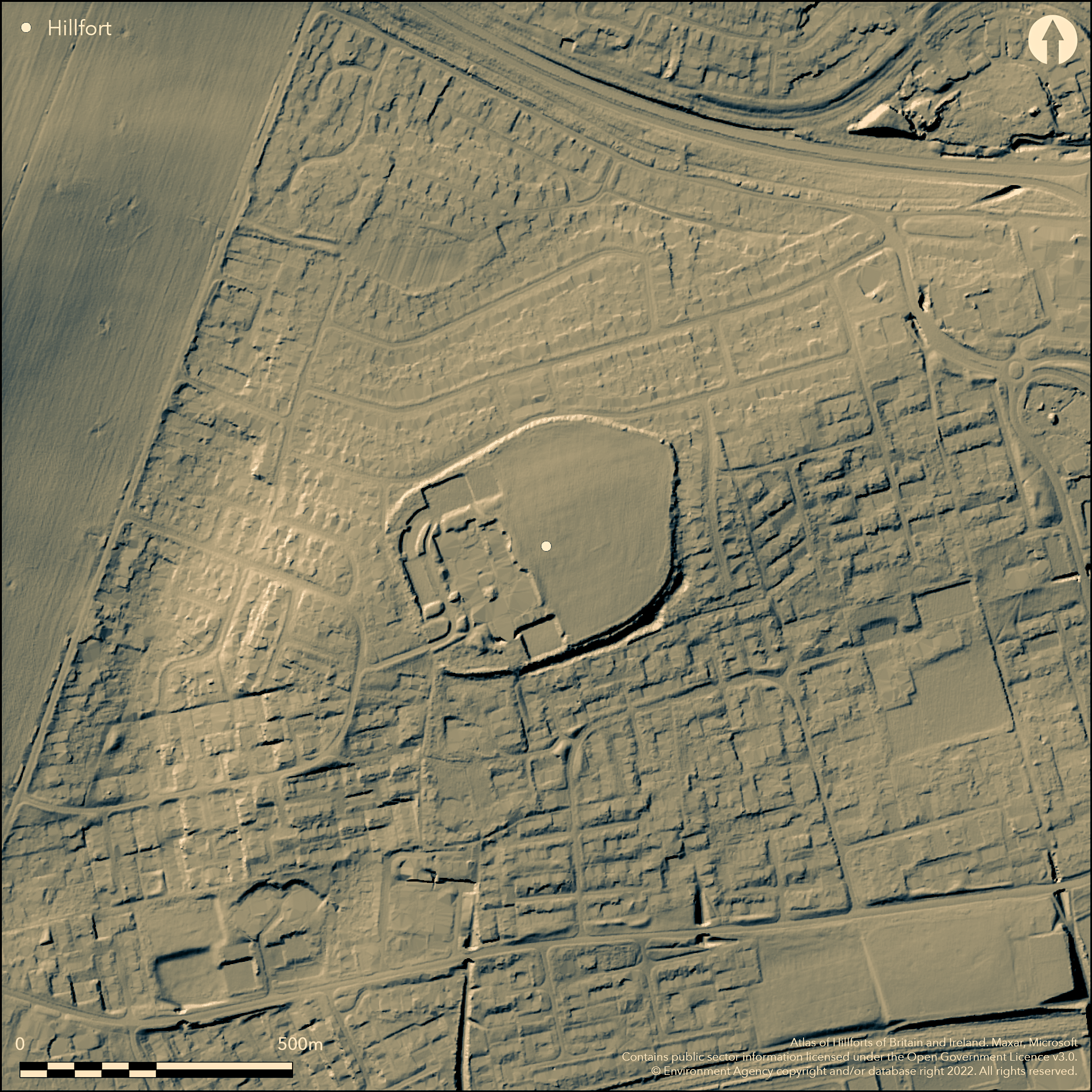
LiDAR 1m DTM Hillshade
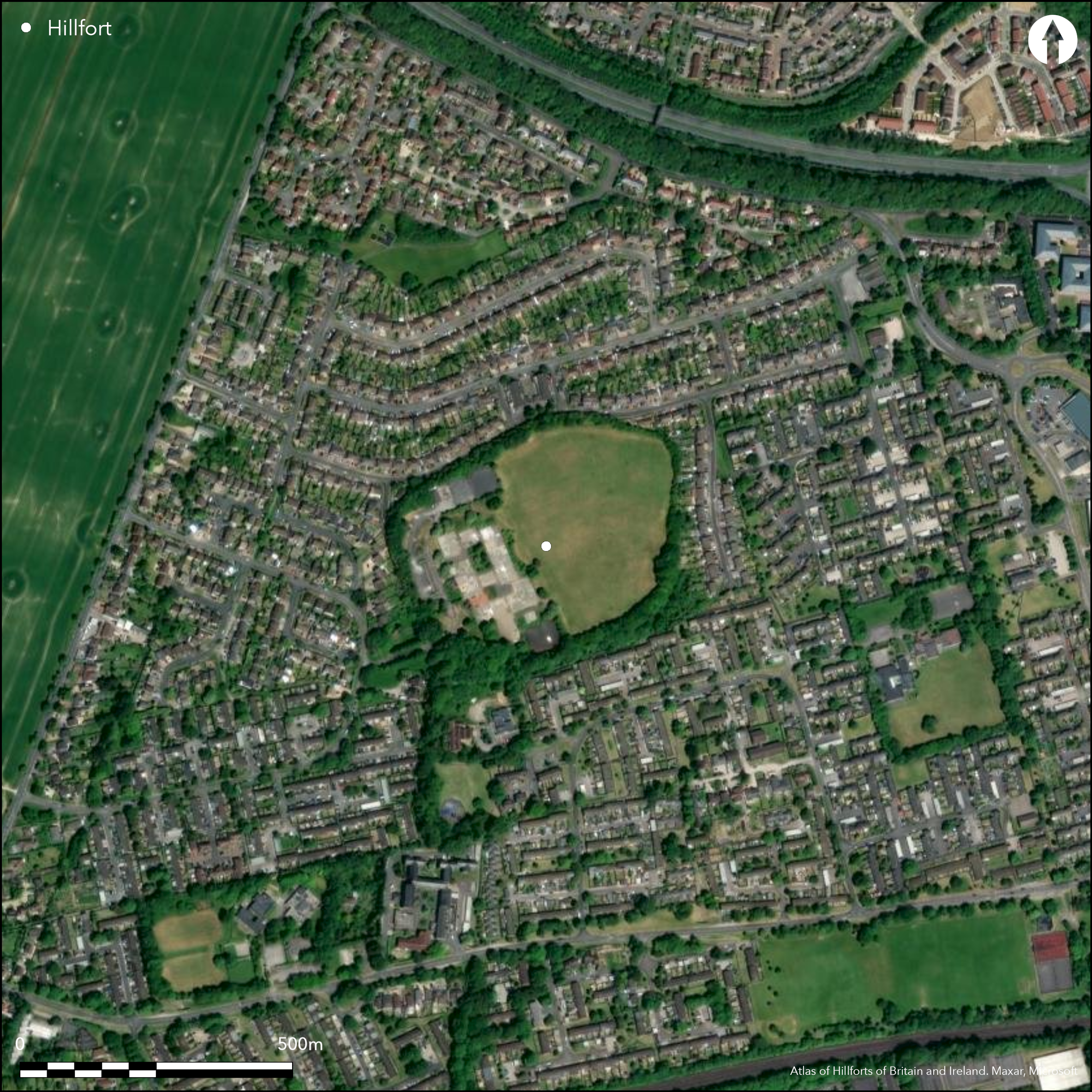
Satellite Imagery
LiDAR 1m DTM Hillshade
Satellite Imagery
Scroll left/right to view further images.
HER: Hampshire 17570 (None)
NMR: SU 65 SW 10 (240631)
SM: 1003559
NGR: SU61355290
X: 461350 Y: 152900 (OSGB36)
Complex, partial contour hillfort, often called a 'plateau fort', located on very slightly SW-sloping plateau of Holybourne Down, with ploughed interior and remaining banks now surrounded, mutilated and encroached by modern Basingstoke suburb development, which masks locational topography. Moderate surrounding slopes surround plateau enclosing area c. 7.6ha. Much of defences lost, but at SW corner length of eroded rampart survives for c. 90m to 2m high. No ditch survives here, but visible on E where c. 200m length to 5m wide and 2m deep. This is crossed at SE corner by a causeway (modern?) and then continues N before becoming lost in domestic gardens. No original entrance visible. Excavations by R. Robertson-Mackay (1977) for the Ministry of Works 1959-60 revealed complex sequence dating from c. fourth to first century BC. Several cuts through ramparts showed three phases: I, timber-faced revetted rampart of ?7th to 6th centuries BC; II, rammed chalk glacis rampart, possibly rebuilt or raised as Phase III - with later saucepan pottery. Possibly late Bronze Age enclosure on the hilltop. A close set palisade had later been covered by rampart and then subsequently enlarged, the ditch yielding evidence for four phases. Pottery and features from later excavations by K. Smith (1977; 1979) indicated two main Iron Age phases; firstly from the 6th to 5th century, and secondly from the 2nd to 1st centuries BC. Four post structures and pits are associated with the first phase, semi-circular gullies, pits and an enclosure are associated with the second phase. In first phase site was univallate enclosed settlementwith single irregular ditch and timber-framed rampart. In second phase rampart modified to sloping glacis bank with V-shaped ditch. Probably a period of abandonment between the two phases. Iron Age sherds, animal bones and base of a deer antler found. Possible evidence of Roman occupation. Burials located at the site display evidence of exposure and excarnation. Pasture interior on c. E two-thirds, development on remainder, trees on surrounds. Development surrounds site and much degraded by ploughing and development in interior on W and on far E. School and playgrounds built in W interior 1977. Subject to vandalism and rubbish dumping. On 1st Ed. OS map (1872-9).
Citizen Science: ✗
Reliability of Data: Confirmed
Reliability of Interpretation: Confirmed
X: -124894 Y: 6669531 (EPSG: 3857)
Longitude: -1.1219418217779586 Latitude: 51.27190016816263 (EPSG:4326)
Country: England; None
Current County or Unitary Authority: Hampshire
Historic County: Hampshire and Isle of Wight
Current Parish/Community/Council/Townland: Basingstoke and Deane; Wootton St. Lawrence
Development surrounds site and much degraded by ploughing and development in interior on W and on far E. School and playgrounds built in W interior 1977. Subject to vandalism and rubbish dumping.
| Extant | ✓ |
| Cropmark | ✗ |
| Likely Destroyed | ✓ |
Pasture interior on c. E two-thirds, development on remainder W. Tress on surrounds.
| Woodland | ✓ |
| Commercial Forestry Plantation | ✗ |
| Parkland | ✗ |
| Pasture (Grazing) | ✓ |
| Arable | ✗ |
| Scrub/Bracken | ✗ |
| Bare Outcrop | ✗ |
| Heather/Moorland | ✗ |
| Heath | ✗ |
| Built-up | ✓ |
| Coastal Grassland | ✗ |
| Other | ✗ |
Partial contour hillfort, often called a 'plateau fort', located on very slightly SW-sloping plateau of Holybourne Down, with ploughed interior and remaining banks now surrounded, mutilated and encroached by modern Basingstoke suburb development, which masks location topography.
| Contour Fort | ✗ |
| Partial Contour Fort | ✗ |
| Promontory Fort | ✗ |
| Hillslope Fort | ✗ |
| Level Terrain Fort | ✓ |
| Marsh Fort | ✗ |
| Multiple Enclosure Fort | ✗ |
| Hilltop | ✗ |
| Coastal Promontory | ✗ |
| Inland Promontory | ✗ |
| Valley Bottom | ✗ |
| Knoll/Hillock/Outcrop | ✗ |
| Ridge | ✗ |
| Cliff/Plateau-edge/Scarp | ✓ |
| Hillslope | ✗ |
| Lowland | ✗ |
| Spur | ✗ |
Dominant Topographic Feature: Plateau
| North | ✗ |
| Northeast | ✗ |
| East | ✗ |
| Southeast | ✗ |
| South | ✗ |
| Southwest | ✓ |
| West | ✗ |
| Northwest | ✗ |
| Level | ✗ |
Altitude: 125.0m
Boundary Type: Parish/Townland
Excavations by R. Robertson-Mackay revealed complex sequence dating from c. 4th to 1st century BC. Several cuts through defences showed three rampart phases: I, timber-faced revetted rampart of ?7th to 6th centuries BC; II, rammed chalk glacis rampart, possibly rebuilt or raised as Phase III - with later saucepan pottery. Possibly late Bronze Age enclosure on the hilltop. A close set palisade had later been covered by rampart and then subsequently enlarged, the ditch yielding evidence for four periods. Pottery and features from later excavations by K. Smith 1975-6 indicated two main Iron Age phases; firstly from the 6th to 5th century, and secondly from the 2nd to 1st centuries BC. Four post structures and pits are associated with the first phase, semi-circular gullies, pits and an enclosure are associated with the second phase. In first phase site univallate defended settlement with single irregular ditch and timber-framed rampart. In second phase rampart modified to sloping glacis bank with V-shaped ditch. Probably a period of abandonment between the two phases. Iron age sherds, animal bones and base of a deer antler found. Possible evidence for Roman activity with possible Samian ware found.
Reliability: B - Medium
| Pre 1200BC | ✗ |
| 1200BC - 800BC | ✗ |
| 800BC - 400BC | ✓ |
| 400BC - AD50 | ✓ |
| AD50 - AD400 | ✓ |
| AD400 - AD 800 | ✗ |
| Post AD800 | ✗ |
| Unknown | ✗ |
| Pre Hillfort: | None |
| Post Hillfort: | None |
| Artefactual: | Iron Age pottery and possible Samian ware. |
| Morphology/Earthwork/Typology: | Various features associated with phases. |
First documented AD 1290 as 'WILTENISCHEBURY' (Fort of the people of Wilton /Shire). In Aubrey's Monumenta Britannica (1665-1693). Survey by Sir Henry Dryden 1844. On 1st Ed. OS map (1872-9). C.H. Read and R.A. Smith found Iron Age sherdsand animal bones in early 1900s. (Finds by Mrs Piggott during widening of an entrance cut in bank 1937. Excavation R. Robertson-Mackay, Ministry of Works, 1959-60. Air Photograph Interpretation RCHME: Park Prewett Project 1968. Excavation K. Smith 1975-6. Geophysical Survey AML 1975-6. Excavation R. T. Schadla-Hall 1980.
| 1st Identified Written Reference (1290): | First documentastion as 'WILTENISCHEBURY' (Fort of the people of Wilton /Shire). |
| 1st Identified Map Depiction (1844): | Survey by Sir Henry Dryden. |
| Other (1937): | Finds by Mrs Piggott during widening of an entrance cut in bank. |
| Other (1968): | Air Photograph Interpretation RCHME: Park Prewett Project. |
| Excavation (1980): | R. T. Schadla-Hall. |
| Other (None): | OS map. |
| Excavation (None): | R. Robertson-Mackay. |
| Excavation (None): | K. Smith. |
| Geophysical Survey (None): | Magnetometer survey AML. |
| Other (None): | C.H. Read and R.A. Smith found Iron Age sherds and animal bones. |
Excavations discovered two main Iron Age phases; firstly from the 6th to 5th century, and secondly from the 2nd to 1st centuries BC. Four post structures and pits are associated with the first phase, semi-circular gullies, pits and an enclosure are associated with the second phase. Iron age sherds, animal bones and base of deer antler. Samian and other undetermined chance finds.
None
| None | ✓ |
| Spring | ✗ |
| Stream | ✗ |
| Pool | ✗ |
| Flush | ✗ |
| Well | ✗ |
| Other | ✗ |
None
| No Known Features | ✓ |
| Round Stone Structures | ✗ |
| Rectangular Stone Structures | ✗ |
| Curvilinear Platforms | ✗ |
| Other Roundhouse Evidence | ✗ |
| Pits | ✗ |
| Quarry Hollows | ✗ |
| Other | ✗ |
Excavations discovered two main Iron Age phases; firstly from the 6th to 5th century, and secondly from the 2nd to 1st centuries BC. Four-post structures and pits are associated with the first phase, semi-circular gullies, pits and an enclosure are associated with the second phase.
| No Known Excavation | ✗ |
| Pits | ✓ |
| Postholes | ✓ |
| Roundhouses | ✗ |
| Rectangular Structures | ✓ |
| Roads/Tracks | ✗ |
| Quarry Hollows | ✗ |
| Other | ✓ |
| Nothing Found | ✗ |
No details.
| No Known Geophysics | ✗ |
| Pits | ✗ |
| Roundhouses | ✗ |
| Rectangular Structures | ✗ |
| Roads/Tracks | ✗ |
| Quarry Hollows | ✗ |
| Other | ✓ |
| Nothing Found | ✗ |
Iron age sherds, animal bones and base of a deer antler. Samian and other undetermined chance finds. Burials located at the site display evidence of exposure and excarnation.
| No Known Finds | ✗ |
| Pottery | ✓ |
| Metal | ✗ |
| Metalworking | ✗ |
| Human Bones | ✓ |
| Animal Bones | ✓ |
| Lithics | ✗ |
| Environmental | ✗ |
| Other | ✓ |
None
| APs Not Checked | ✓ |
| None | ✗ |
| Roundhouses | ✗ |
| Rectangular Structures | ✗ |
| Pits | ✗ |
| Postholes | ✗ |
| Roads/Tracks | ✗ |
| Other | ✗ |
No original entrance visible.
| 0: | Not determined - much destroyed. |
| 2: | None |
Guard Chambers: ✗
Chevaux de Frise: ✗
Much of defences lost, but at SW corner length of eroded rampart survives for c. 90m to 2m high. No ditch survives here, but visible on E where c. 200m length to 5m wide and 2m deep. This is crossed at SE corner by a causeway (modern?) and then continues N before becoming lost in domestic gardens. Excavations R. Robertson-Mackay for the found close-set palisade later covered by rampart and then subsequently enlarged. Later K. Smith found in a first Iron Age phase site univallate defended settlement with single irregular ditch and timber-framed rampart. In second phase rampart modified to sloping glacis bank with V-shaped ditch. Probably a period of abandonment between the two phases.
| Area 1: | 7.6ha. |
| Total: | 7.6ha. |
Total Footprint Area: Noneha.
None
| ✓ | Excavations by R. Robertson-Mackay for the Ministry of Works 1959-60 revealed complex sequence dating from c. fourth to first century BC. A close set palisade had later been covered by rampart and then subsequently enlarged, the ditch yielding evidence for four periods. Pottery and features from later excavations by K. Smith 1975-6 indicated two main Iron Age phases; firstly from the 6th to 5th century, and secondly from the 2nd to 1st centuries BC. Four post structures and pits are associated with the first phase, semi-circular gullies, pits and an enclosure are associated with the second phase. In first phase site univallate defended settlement with single irregular ditch and timber-framed rampart. In second phase rampart modified to sloping glacis bank with V-shaped ditch. Probably a period of abandonment between the two phases. |
| ✗ | Ramparts nearly destroyed, apart from short length at SW corner. |
| NE Quadrant: | 0 |
| SE Quadrant: | 0 |
| SW Quadrant: | 1 |
| NW Quadrant: | 0 |
| Total: | 1 |
| Partial Univallate | ✓ |
| Univallate | ✗ |
| Partial Bivallate | ✗ |
| Bivallate | ✗ |
| Partial Multivallate | ✗ |
| Multivallate | ✗ |
| Unknown | ✗ |
| Partial Univallate | ✗ |
| Univallate | ✓ |
| Partial Bivallate | ✗ |
| Bivallate | ✗ |
| Partial Multivallate | ✗ |
| Multivallate | ✗ |
None
| None | ✗ |
| Earthen Bank | ✓ |
| Stone Wall | ✗ |
| Rubble | ✗ |
| Wall-walk | ✗ |
| Evidence of Timber | ✗ |
| Vitrification | ✗ |
| Other Burning | ✗ |
| Palisade | ✗ |
| Counter Scarp Bank | ✗ |
| Berm | ✗ |
| Unfinished | ✗ |
| Other | ✗ |
Excavations R. Robertson-Mackay found close-set palisade later covered by rampart and then subsequently enlarged. Later K. Smith found in a first Iron Age phase site univallate defended settlement with single irregular ditch and timber-framed rampart. In second phase rampart modified to sloping glacis bank with V-shaped ditch. Probably a period of abandonment between the two phases.
| None | ✗ |
| Earthen Bank | ✓ |
| Stone Wall | ✗ |
| Murus Duplex | ✗ |
| Timber-framed | ✓ |
| Timber-laced | ✗ |
| Vitrification | ✗ |
| Other Burning | ✗ |
| Palisade | ✓ |
| Counter Scarp Bank | ✗ |
| Berm | ✗ |
| Unfinished | ✗ |
| No Known Excavation | ✗ |
| Other | ✓ |
| ✗ | None |
| ✓ | In first Iron Age phase site univallate defended settlement with single irregular ditch and timber-framed rampart. In second phase rampart modified to sloping glacis bank with V-shaped ditch. |
Number of Ditches: 1
| ✗ | None |
Bartlett, A. no date. Geophysics from Winklebury, AML Rep No 2209, Ancient Monuments Laboratory English Heritage.
Fisher,A.R. 1985. Winklebury Hillfort: a study of artefact distributions from subsoil features, Proc Prehist Soc, 51, 167-80.
Hampton, J. 1989. The Air Photography Unit of The Royal Commission on the Historical Monuments of England 1965-1985, In ed D. Kennedy, Into the Sun: Essays in Air Photography in Archaeology in Honour of Derrick Riley, 13-28, fig. 4.6.
Robertson- Mackay, R. 1977. The defences of the Iron Age hillfort at Winklebury, Basingstoke, Hampshire, Proc Prehist Soc, 43, 31-154.
Schadla-Hall 1980R.T. 1980. Note, CBA Group 12: Newsletter, Sep 1980/9.
Smith, K. 1977. The excavation of Winklebury Camp, Basingstoke, Hampshire, Proc Prehist Soc, 43, 31-129.
Smith, K. 1979. Winklebury Camp, Basingstoke [Hants]: a note. Proc Prehist Soc, 45, 321-2.
Atlas of Hillforts:
Wikidata:
This work is licensed under CC BY-SA 4.0

 and should be cited as:
Lock, Gary and Ralston, Ian. 2024. Atlas of Hillforts of Britain and Ireland. Available at: https://hillforts.arch.ox.ac.uk
Document Version 1.1