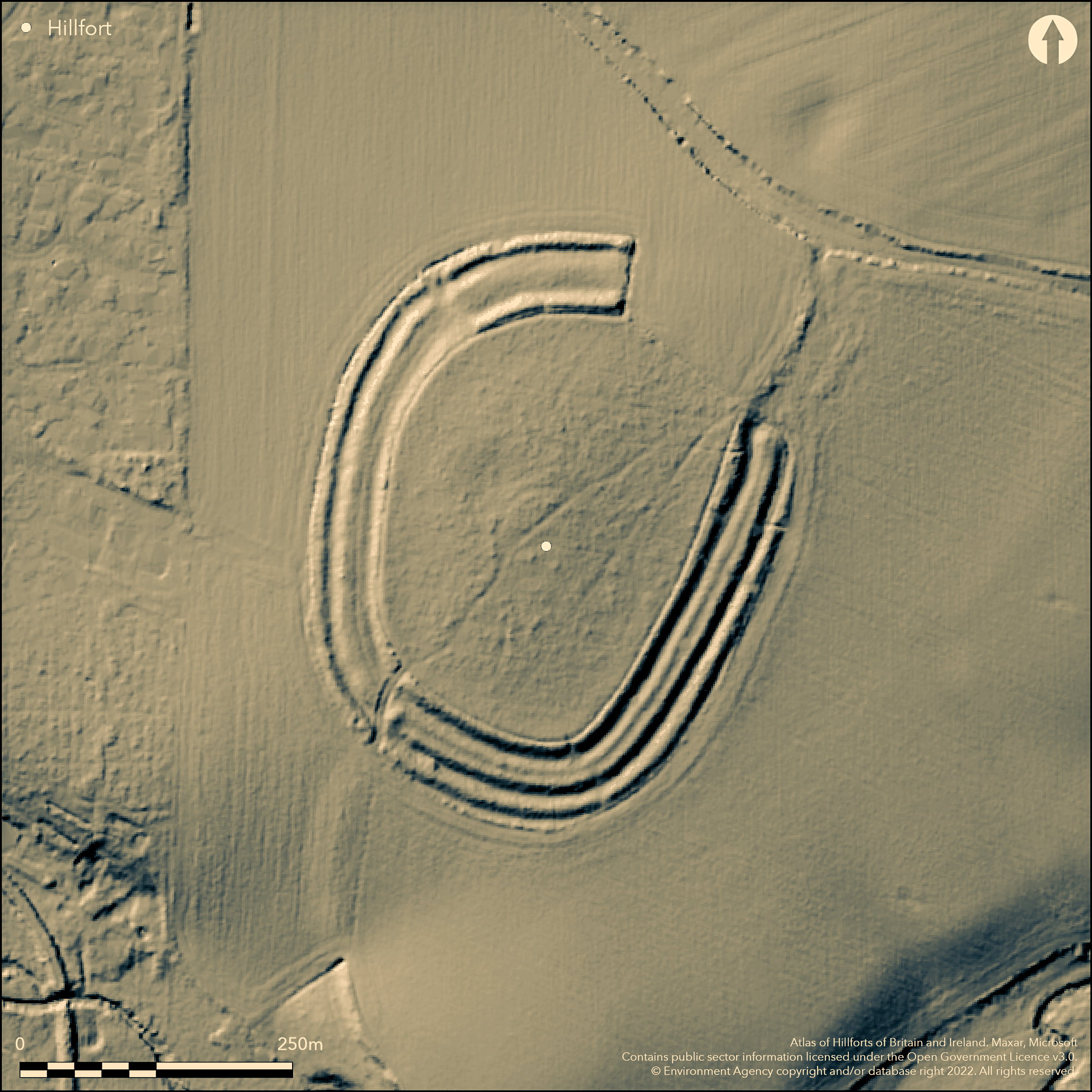
LiDAR 1m DTM Hillshade
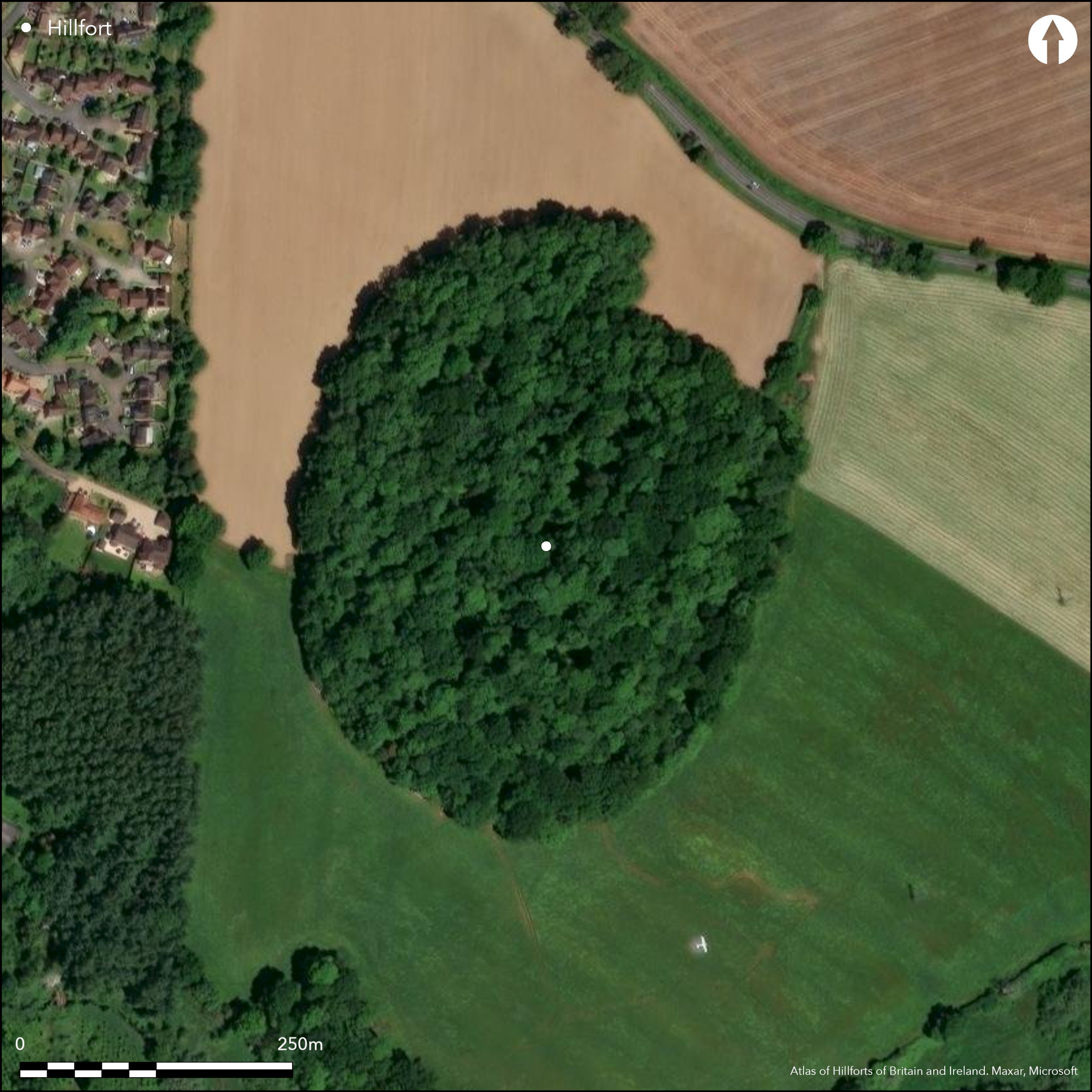
Satellite Imagery
LiDAR 1m DTM Hillshade
Satellite Imagery
Scroll left/right to view further images.
HER: Hampshire 20768 (None)
NMR: SU 65 NE 2 (240247)
SM: 1001944
NGR: SU67085838
X: 467080 Y: 158380 (OSGB36)
Multivallate contour fort sited on gently rounded low hill at N edge of plateau on heavy clay soil, within prominent bend of Bow Brook to S and near its confluence with the River Loddon to NE, in prominent position with good views in all directions. Moderate to level surrounding slopes. Irregular oval in shape, following the brow of the hill and enclosing c. 4ha with total footprint 8ha. On E slope less and ramparts consist of an inner bank, mutilated by boundary, with ditch, significant wide berm and second bank with deep ditch and outer bank, which is probably a counterscarp. On W slope greater and here, with wide terrace with upper and lower scarps, result of levelling of natural slope, and ditch and outer bank, probably a counterscarp. Around surviving part of N side is an inner bank above the terrace. Banks largely destroyed for c. 100m on NE. Original entrance on NW. Simple gap with outer bank inturned across line of ditch. SW gap modern. Circular mound in the centre uncertain as original feature. Densely wooded making interpretation difficult. Surrounded by streams and boggy ground to N, E and S and site may have been a marsh fort in prehistory. Unlikely to have been an oppidum preceding nearby Silchester, as suggested by G.C. Boon (in Pastscape). On 1st Ed. OS map (1873). Few investigations, undated.
Citizen Science: ✓
Reliability of Data: Confirmed
Reliability of Interpretation: Confirmed
X: -115637 Y: 6678188 (EPSG: 3857)
Longitude: -1.038784987031099 Latitude: 51.32052443586537 (EPSG:4326)
Country: England; None
Current County or Unitary Authority: Hampshire
Historic County: Hampshire and Isle of Wight
Current Parish/Community/Council/Townland: Bramley; Sherfield on Loddon
Dense vegetation makes interpretation difficult and banks destroyed in part.
| Extant | ✓ |
| Cropmark | ✗ |
| Likely Destroyed | ✗ |
Dense oak and fir wooded. Surrounded by streams and boggy ground.
| Woodland | ✓ |
| Commercial Forestry Plantation | ✗ |
| Parkland | ✗ |
| Pasture (Grazing) | ✗ |
| Arable | ✗ |
| Scrub/Bracken | ✓ |
| Bare Outcrop | ✗ |
| Heather/Moorland | ✗ |
| Heath | ✗ |
| Built-up | ✗ |
| Coastal Grassland | ✗ |
| Other | ✗ |
Multivallate hillfort, contour hillfort, sited on gently rounded low hill at N edge of plateau on heavy clay soil, within prominent bend of Bow Brook to S and near its confluence with the River Loddon to NE, in fine controlling position. Moderate to level surrounding slopes. Boggy ground and brooks surround to N, E and S and may have been a marsh fort in prehistory.
| Contour Fort | ✓ |
| Partial Contour Fort | ✗ |
| Promontory Fort | ✗ |
| Hillslope Fort | ✗ |
| Level Terrain Fort | ✗ |
| Marsh Fort | ✓ |
| Multiple Enclosure Fort | ✗ |
| Hilltop | ✓ |
| Coastal Promontory | ✗ |
| Inland Promontory | ✗ |
| Valley Bottom | ✗ |
| Knoll/Hillock/Outcrop | ✗ |
| Ridge | ✗ |
| Cliff/Plateau-edge/Scarp | ✗ |
| Hillslope | ✗ |
| Lowland | ✗ |
| Spur | ✗ |
Dominant Topographic Feature: Hill top
| North | ✗ |
| Northeast | ✗ |
| East | ✗ |
| Southeast | ✗ |
| South | ✗ |
| Southwest | ✗ |
| West | ✗ |
| Northwest | ✗ |
| Level | ✓ |
Altitude: 67.0m
Boundary Type: Parish/Townland
None.
Reliability: D - None
| Pre 1200BC | ✗ |
| 1200BC - 800BC | ✗ |
| 800BC - 400BC | ✗ |
| 400BC - AD50 | ✗ |
| AD50 - AD400 | ✗ |
| AD400 - AD 800 | ✗ |
| Post AD800 | ✗ |
| Unknown | ✓ |
| Pre Hillfort: | None |
| Post Hillfort: | None |
On 1st Ed. OS map (1873). Field investigator comments 1956, 1967, 1982.
| 1st Identified Map Depiction (1873): | OS map. |
| Other (None): | Field investigator comments - no details. |
None.
None
| None | ✓ |
| Spring | ✗ |
| Stream | ✗ |
| Pool | ✗ |
| Flush | ✗ |
| Well | ✗ |
| Other | ✗ |
None
| No Known Features | ✓ |
| Round Stone Structures | ✗ |
| Rectangular Stone Structures | ✗ |
| Curvilinear Platforms | ✗ |
| Other Roundhouse Evidence | ✗ |
| Pits | ✗ |
| Quarry Hollows | ✗ |
| Other | ✗ |
None
| No Known Excavation | ✓ |
| Pits | ✗ |
| Postholes | ✗ |
| Roundhouses | ✗ |
| Rectangular Structures | ✗ |
| Roads/Tracks | ✗ |
| Quarry Hollows | ✗ |
| Other | ✗ |
| Nothing Found | ✗ |
None
| No Known Geophysics | ✓ |
| Pits | ✗ |
| Roundhouses | ✗ |
| Rectangular Structures | ✗ |
| Roads/Tracks | ✗ |
| Quarry Hollows | ✗ |
| Other | ✗ |
| Nothing Found | ✗ |
None
| No Known Finds | ✓ |
| Pottery | ✗ |
| Metal | ✗ |
| Metalworking | ✗ |
| Human Bones | ✗ |
| Animal Bones | ✗ |
| Lithics | ✗ |
| Environmental | ✗ |
| Other | ✗ |
None
| APs Not Checked | ✓ |
| None | ✗ |
| Roundhouses | ✗ |
| Rectangular Structures | ✗ |
| Pits | ✗ |
| Postholes | ✗ |
| Roads/Tracks | ✗ |
| Other | ✗ |
Original entrance on NW. Simple gap with outer bank inturned across line of ditch. Circular mound in the centre uncertain as original feature. Gap on SW modern, but large c. 91m gap in circuit on NE.
| 2: | Gap on SW modern, but large c. 91m gap in circuit on NE. |
| 2: | None |
Guard Chambers: ✗
Chevaux de Frise: ✗
| 1. In-turned (North west): | None |
On E slope less and ramparts consist of an inner bank, mutilated by boundary, with ditch, wide berm and second bank with deep ditch and outer bank which is probably a counterscarp. On W slope greater and here, with wide terrace with upper and lower scarps, result of levelling of natural slope, and ditch and outer bank. Around surviving part of N side is an inner bank above the terrace. Banks largely destroyed for c. 100m on NE. It is possible that the outer bank may be a counterscarp.
| Area 1: | 4.0ha. |
| Total: | 4.0ha. |
Total Footprint Area: 8.0ha.
None
| ✗ | Areas possibly greater, but dense woodland precludes accurate definition. |
| ✓ | It is possible that the outer bank is a counterscarp. In that case the site is bivallate as quadrants defined. |
| NE Quadrant: | 2 |
| SE Quadrant: | 2 |
| SW Quadrant: | 2 |
| NW Quadrant: | 2 |
| Total: | 2 |
| Partial Univallate | ✗ |
| Univallate | ✗ |
| Partial Bivallate | ✗ |
| Bivallate | ✓ |
| Partial Multivallate | ✗ |
| Multivallate | ✗ |
| Unknown | ✗ |
| Partial Univallate | ✗ |
| Univallate | ✗ |
| Partial Bivallate | ✗ |
| Bivallate | ✗ |
| Partial Multivallate | ✗ |
| Multivallate | ✗ |
It is possible that the outer bank may be a counterscarp, but not determined. Wide and significant berm.
| None | ✗ |
| Earthen Bank | ✓ |
| Stone Wall | ✗ |
| Rubble | ✗ |
| Wall-walk | ✗ |
| Evidence of Timber | ✗ |
| Vitrification | ✗ |
| Other Burning | ✗ |
| Palisade | ✗ |
| Counter Scarp Bank | ✓ |
| Berm | ✓ |
| Unfinished | ✗ |
| Other | ✗ |
None
| None | ✗ |
| Earthen Bank | ✗ |
| Stone Wall | ✗ |
| Murus Duplex | ✗ |
| Timber-framed | ✗ |
| Timber-laced | ✗ |
| Vitrification | ✗ |
| Other Burning | ✗ |
| Palisade | ✗ |
| Counter Scarp Bank | ✗ |
| Berm | ✗ |
| Unfinished | ✗ |
| No Known Excavation | ✓ |
| Other | ✗ |
| ✗ | None |
| ✓ | No detail of ditch to outer bank, and as result probably counterscarp. |
Number of Ditches: 2
| ✗ | None |
Williams-Freeman, J.P. 1915. An introduction to field archaeology as illustrated by Hampshire, London: Macmillan and Co Ltd.
Atlas of Hillforts:
Wikidata:
This work is licensed under CC BY-SA 4.0

 and should be cited as:
Lock, Gary and Ralston, Ian. 2024. Atlas of Hillforts of Britain and Ireland. Available at: https://hillforts.arch.ox.ac.uk
Document Version 1.1