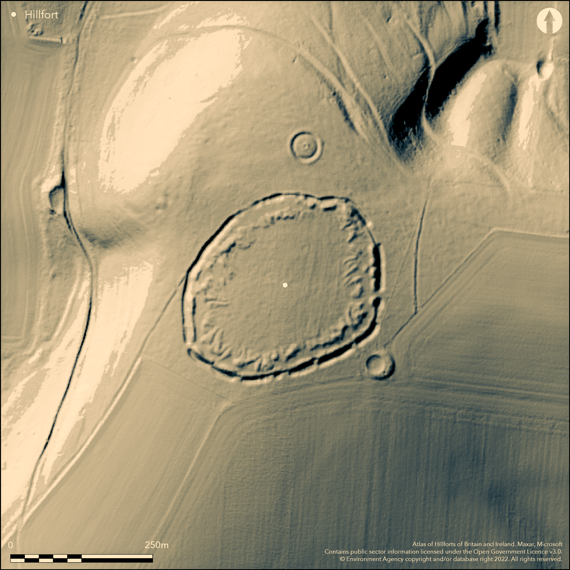
LiDAR 1m DTM Hillshade
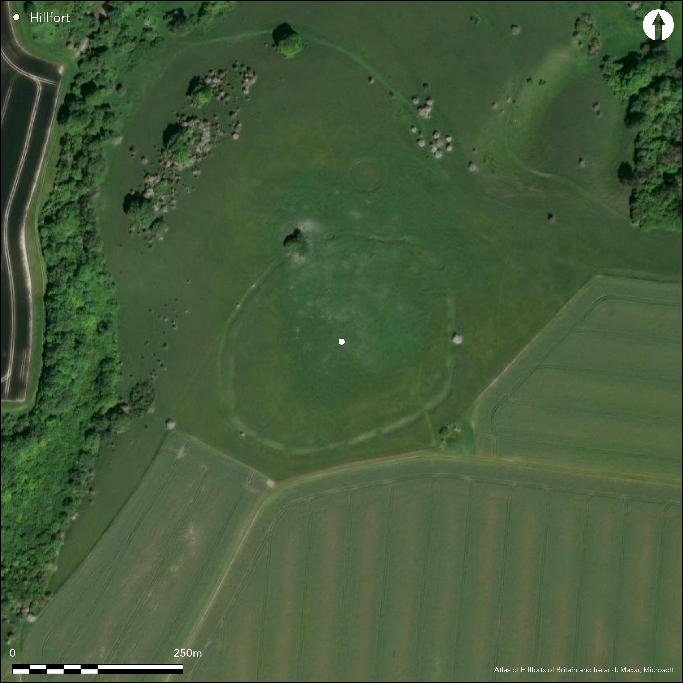
Satellite Imagery
LiDAR 1m DTM Hillshade
Satellite Imagery
Scroll left/right to view further images.
HER: Hampshire 21450 (None)
NMR: SU 45 NE 15 (232435)
SM: 1012038
NGR: SU47885684
X: 447880 Y: 156840 (OSGB36)
Unfinished, univallate contour hillfort situated on Ladle Hill. Very steep surrounding slopes from SW through to NE, steep elsewhere. Site has incomplete ditch and internal bank with irregular inner circuit of soil dumps and overall external dimensions of c. 227m E-W by c. 208m, with interior area 2.8ha. Ditch has separate sections of varying size, of which most complete, c.1 60m long and to 1.6m deep on W, but only c. 50m of bank built towards S end of ditch. One of two probable entrances lies at S end of long W ditch section, other on E side. Slight ditch and bank visible across unexcavated causeways between ditch sections, except at entrances, possibly used to mark out extent of hillfort. Low bank runs along outer edge NW and N arc of ditch from where earlier convergent linear earthwork disappears; possibly associated with this earlier feature rather than with hillfort. Interior has irregular array of soil dumps set back from line of bank, and an earlier saucer barrow. Disc barrow outside fort.Two earlier linear earthworks nearby. Longest runs along W edge of Great Litchfield Down and incorporated in ditch of hillfort. Second linear runs N-S 30m to E of first. The best example of an unfinished hillfort in England. Survey as part of the English Heritage Wessex Hillforts Project (Payne et. al. 2006). On 1st Ed. OS map (1873).
Citizen Science: ✗
Reliability of Data: Confirmed
Reliability of Interpretation: Confirmed
X: -146329 Y: 6676067 (EPSG: 3857)
Longitude: -1.3144918258002054 Latitude: 51.30861482489307 (EPSG:4326)
Country: England; None
Current County or Unitary Authority: Hampshire
Historic County: Hampshire and Isle of Wight
Current Parish/Community/Council/Townland: Basingstoke and Deane; Burghclere
Well-preserved.
| Extant | ✓ |
| Cropmark | ✗ |
| Likely Destroyed | ✗ |
Rough pasture. SSSI.
| Woodland | ✗ |
| Commercial Forestry Plantation | ✗ |
| Parkland | ✗ |
| Pasture (Grazing) | ✓ |
| Arable | ✗ |
| Scrub/Bracken | ✗ |
| Bare Outcrop | ✗ |
| Heather/Moorland | ✗ |
| Heath | ✗ |
| Built-up | ✗ |
| Coastal Grassland | ✗ |
| Other | ✗ |
Unfinished, univallate contour hillfort situated on Ladle Hill. Very steep surrounding slopes from SW through to NE, steep elsewhere.
| Contour Fort | ✓ |
| Partial Contour Fort | ✗ |
| Promontory Fort | ✗ |
| Hillslope Fort | ✗ |
| Level Terrain Fort | ✗ |
| Marsh Fort | ✗ |
| Multiple Enclosure Fort | ✗ |
| Hilltop | ✓ |
| Coastal Promontory | ✗ |
| Inland Promontory | ✗ |
| Valley Bottom | ✗ |
| Knoll/Hillock/Outcrop | ✗ |
| Ridge | ✗ |
| Cliff/Plateau-edge/Scarp | ✗ |
| Hillslope | ✗ |
| Lowland | ✗ |
| Spur | ✗ |
Dominant Topographic Feature: Hill top
| North | ✗ |
| Northeast | ✗ |
| East | ✗ |
| Southeast | ✗ |
| South | ✗ |
| Southwest | ✗ |
| West | ✗ |
| Northwest | ✗ |
| Level | ✓ |
Altitude: 234.0m
Boundary Type: Parish/Townland
Possibly early Iron Age.
Reliability: D - None
| Pre 1200BC | ✗ |
| 1200BC - 800BC | ✗ |
| 800BC - 400BC | ✗ |
| 400BC - AD50 | ✗ |
| AD50 - AD400 | ✗ |
| AD400 - AD 800 | ✗ |
| Post AD800 | ✗ |
| Unknown | ✓ |
| Pre Hillfort: | Saucer barrow in NE interior, possible site of antiquarian digging; disc barrow outside 30m to N. |
| Post Hillfort: | None |
| Morphology/Earthwork/Typology: | Possibly early Iron Age. |
On 1st Ed. OS map (1873). Field investigator comments 1967, 1982. Geophysical survey Wessex Hillforts Project 1997.
| 1st Identified Map Depiction (1873): | OS map. |
| Other (1971): | Visited by Hillfort Study Group |
| Geophysical Survey (1997): | Wessex Hillforts Project. |
| Other (None): | Field investigator comments - no details. |
Geophysical survey found no features.
None
| None | ✓ |
| Spring | ✗ |
| Stream | ✗ |
| Pool | ✗ |
| Flush | ✗ |
| Well | ✗ |
| Other | ✗ |
None
| No Known Features | ✓ |
| Round Stone Structures | ✗ |
| Rectangular Stone Structures | ✗ |
| Curvilinear Platforms | ✗ |
| Other Roundhouse Evidence | ✗ |
| Pits | ✗ |
| Quarry Hollows | ✗ |
| Other | ✗ |
None
| No Known Excavation | ✓ |
| Pits | ✗ |
| Postholes | ✗ |
| Roundhouses | ✗ |
| Rectangular Structures | ✗ |
| Roads/Tracks | ✗ |
| Quarry Hollows | ✗ |
| Other | ✗ |
| Nothing Found | ✗ |
Geophysical survey found no features.
| No Known Geophysics | ✗ |
| Pits | ✗ |
| Roundhouses | ✗ |
| Rectangular Structures | ✗ |
| Roads/Tracks | ✗ |
| Quarry Hollows | ✗ |
| Other | ✗ |
| Nothing Found | ✓ |
None
| No Known Finds | ✓ |
| Pottery | ✗ |
| Metal | ✗ |
| Metalworking | ✗ |
| Human Bones | ✗ |
| Animal Bones | ✗ |
| Lithics | ✗ |
| Environmental | ✗ |
| Other | ✗ |
None
| APs Not Checked | ✓ |
| None | ✗ |
| Roundhouses | ✗ |
| Rectangular Structures | ✗ |
| Pits | ✗ |
| Postholes | ✗ |
| Roads/Tracks | ✗ |
| Other | ✗ |
One of two probable entrances lies at S end of long W ditch section, other on E side.
| 2: | None |
| 2: | None |
Guard Chambers: ✗
Chevaux de Frise: ✗
| 1. Simple Gap (South west): | None |
| 2. Simple Gap (East): | None |
Site has incomplete ditch and internal bank with irregular inner circuit of soil dumps.
| Area 1: | 2.8ha. |
| Total: | 2.8ha. |
Total Footprint Area: Noneha.
None
| ✗ | None |
| ✓ | None |
| NE Quadrant: | 1 |
| SE Quadrant: | 1 |
| SW Quadrant: | 1 |
| NW Quadrant: | 1 |
| Total: | 1 |
| Partial Univallate | ✗ |
| Univallate | ✓ |
| Partial Bivallate | ✗ |
| Bivallate | ✗ |
| Partial Multivallate | ✗ |
| Multivallate | ✗ |
| Unknown | ✗ |
| Partial Univallate | ✗ |
| Univallate | ✗ |
| Partial Bivallate | ✗ |
| Bivallate | ✗ |
| Partial Multivallate | ✗ |
| Multivallate | ✗ |
Irregular inner circuit of soil dumps.
| None | ✗ |
| Earthen Bank | ✓ |
| Stone Wall | ✗ |
| Rubble | ✗ |
| Wall-walk | ✗ |
| Evidence of Timber | ✗ |
| Vitrification | ✗ |
| Other Burning | ✗ |
| Palisade | ✗ |
| Counter Scarp Bank | ✗ |
| Berm | ✗ |
| Unfinished | ✓ |
| Other | ✓ |
None
| None | ✗ |
| Earthen Bank | ✗ |
| Stone Wall | ✗ |
| Murus Duplex | ✗ |
| Timber-framed | ✗ |
| Timber-laced | ✗ |
| Vitrification | ✗ |
| Other Burning | ✗ |
| Palisade | ✗ |
| Counter Scarp Bank | ✗ |
| Berm | ✗ |
| Unfinished | ✗ |
| No Known Excavation | ✓ |
| Other | ✗ |
| ✓ | Possible evidence. Rampart constructed in short, straight lengths, with marked changes of alignment (Payne at al 2006, 112). |
| ✓ | None |
Number of Ditches: 1
| ✗ | None |
Payne, A, Corney, M. and Cunliffe, B. 2006. The Wessex hillforts project, Extensive survey of hillfort interiors in central southern England. London: English Heritage, 62-65.
Piggott, S. 1931. Ladle Hill-an unfinished hillfort, Antiq, 5, 1931, 474-85.
Williams-Freeman, J.P. 1915. An introduction to field archaeology as illustrated by Hampshire, London: Macmillan and Co Ltd, 380.
Atlas of Hillforts:
Wikidata:
This work is licensed under CC BY-SA 4.0

 and should be cited as:
Lock, Gary and Ralston, Ian. 2024. Atlas of Hillforts of Britain and Ireland. Available at: https://hillforts.arch.ox.ac.uk
Document Version 1.1