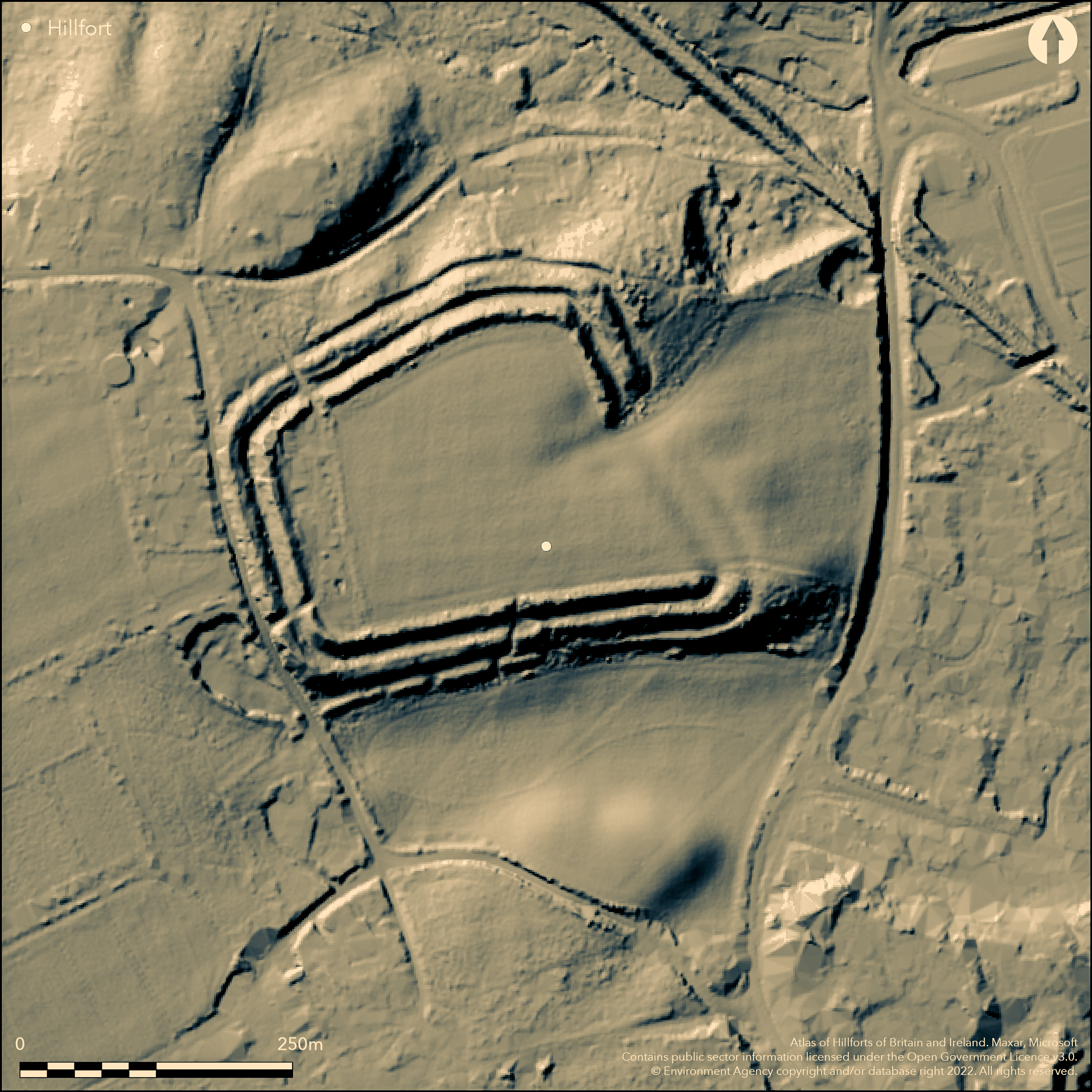
LiDAR 1m DTM Hillshade
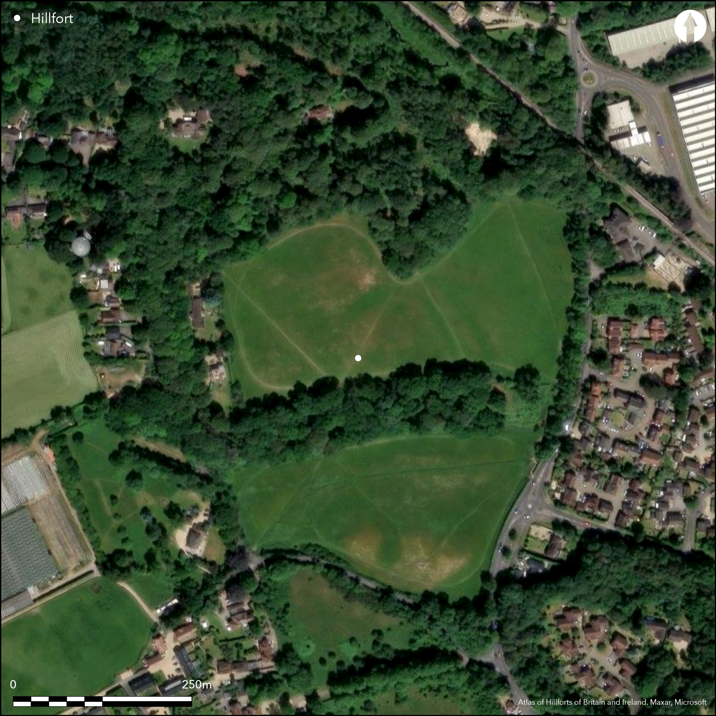
Satellite Imagery
LiDAR 1m DTM Hillshade
Satellite Imagery
Scroll left/right to view further images.
HER: Hampshire 21843 (None)
NMR: SZ 39 NW 7 (459634)
SM: 1008706
NGR: SZ315968
X: 431500 Y: 96800 (OSGB36)
Multivallate partial contour hillfort located on edge of higher ground S of Passford Water and just W of Lymington River flood plain. Moderate to strong slopes to E, moderate elsewhere. Sub-rectangular shape, measuring internally c. 225m E-W by c. 160m, with internal area c. 3.2ha. N, E and S ramparts follow the contours of higher ground, with three banks and two intermediate ditches with a maximum overall width of c. 40m, except near NW corner. W side, on more level ground, has two banks and single ditch. Inner bank best to maximum 6m above base of 10m wide ditch and to 2.5m above interior. Middle bank to 2m-3m above base of inner ditch and to 10m wide at E and N. Outer bank 2m- 3m high for much of length but generally narrower and intermittent on S side. Road runs along foot of, and truncated, outer bank and no evidence of bank or ditch to W of road. E entrance, with terminals of N ramparts, but S banks much reduced by ploughing. Small-scale excavation (Hawkes 1937) found entrance inturned, with two large internal post holes, probably for gate. Sealed by buried ground surface beneath ramparts were hearth, several worked flints and part of Neolithic stone mace. House and cottage in W interior. pasture interior. On 1st Ed. OS map (1868). Undated.
Citizen Science: ✓
Reliability of Data: Confirmed
Reliability of Interpretation: Confirmed
X: -173067 Y: 6580687 (EPSG: 3857)
Longitude: -1.5546836880649773 Latitude: 50.769869655806716 (EPSG:4326)
Country: England; None
Current County or Unitary Authority: Hampshire
Historic County: Hampshire and Isle of Wight
Current Parish/Community/Council/Townland: Lymington and Pennington; Boldre
Well-preserved despite some plough damage. House and cottage in interior to W. Purchased by County Council 1989.
| Extant | ✓ |
| Cropmark | ✗ |
| Likely Destroyed | ✗ |
Pasture interior.
| Woodland | ✗ |
| Commercial Forestry Plantation | ✗ |
| Parkland | ✗ |
| Pasture (Grazing) | ✓ |
| Arable | ✗ |
| Scrub/Bracken | ✗ |
| Bare Outcrop | ✗ |
| Heather/Moorland | ✗ |
| Heath | ✗ |
| Built-up | ✓ |
| Coastal Grassland | ✗ |
| Other | ✗ |
Multivallate partial contour hillfort located on edge of higher ground S of Passford Water and just W of Lymington River flood plain. Moderate to strong slopes to E, moderate elsewhere.
| Contour Fort | ✗ |
| Partial Contour Fort | ✓ |
| Promontory Fort | ✗ |
| Hillslope Fort | ✗ |
| Level Terrain Fort | ✗ |
| Marsh Fort | ✗ |
| Multiple Enclosure Fort | ✗ |
| Hilltop | ✗ |
| Coastal Promontory | ✗ |
| Inland Promontory | ✗ |
| Valley Bottom | ✗ |
| Knoll/Hillock/Outcrop | ✗ |
| Ridge | ✗ |
| Cliff/Plateau-edge/Scarp | ✓ |
| Hillslope | ✗ |
| Lowland | ✓ |
| Spur | ✗ |
Dominant Topographic Feature: Plateau edge.
| North | ✗ |
| Northeast | ✓ |
| East | ✗ |
| Southeast | ✗ |
| South | ✗ |
| Southwest | ✗ |
| West | ✗ |
| Northwest | ✗ |
| Level | ✗ |
Altitude: 15.0m
Boundary Type: Parish/Townland
None.
Reliability: D - None
| Pre 1200BC | ✗ |
| 1200BC - 800BC | ✗ |
| 800BC - 400BC | ✗ |
| 400BC - AD50 | ✗ |
| AD50 - AD400 | ✗ |
| AD400 - AD 800 | ✗ |
| Post AD800 | ✗ |
| Unknown | ✓ |
| Pre Hillfort: | Evidence for possible Neolithic and Bronze Age occupation. Sealed by buried ground surface beneath ramparts were hearth, several worked flints and part of Neolithic stone mace. |
| Post Hillfort: | None |
On 1st Ed. OS map (1868). Small excavation C.R.C. Hawkes 1934-5. Geophysical survey AML 1993. Watching Brief Buckland Rings Cottage AC Archaeology 2009. New Forest NPA LiDAR survey - Citizen Science 2015.
| 1st Identified Map Depiction (1868): | OS map. |
| Geophysical Survey (1993): | Ancient Monuments Laboratory. |
| Other (2009): | Watching Brief AC Archaeology. |
| LiDAR Survey (2015): | New Forest NPA. |
| Excavation (None): | C.F.C. Hawkes. |
Surveys for Hampshire County Council for management purposes gave evidence of entrance features and position of former excavations, but unable to give conclusive evidence for occupation. Postholes and hearth.
None
| None | ✓ |
| Spring | ✗ |
| Stream | ✗ |
| Pool | ✗ |
| Flush | ✗ |
| Well | ✗ |
| Other | ✗ |
None
| No Known Features | ✓ |
| Round Stone Structures | ✗ |
| Rectangular Stone Structures | ✗ |
| Curvilinear Platforms | ✗ |
| Other Roundhouse Evidence | ✗ |
| Pits | ✗ |
| Quarry Hollows | ✗ |
| Other | ✗ |
None
| No Known Excavation | ✗ |
| Pits | ✗ |
| Postholes | ✓ |
| Roundhouses | ✗ |
| Rectangular Structures | ✗ |
| Roads/Tracks | ✗ |
| Quarry Hollows | ✗ |
| Other | ✓ |
| Nothing Found | ✗ |
Surveys for Hampshire County Council for management purposes gave evidence of entrance features and position of former excavations, but unable to give conclusive evidence for occupation.
| No Known Geophysics | ✗ |
| Pits | ✗ |
| Roundhouses | ✗ |
| Rectangular Structures | ✗ |
| Roads/Tracks | ✗ |
| Quarry Hollows | ✗ |
| Other | ✓ |
| Nothing Found | ✗ |
None
| No Known Finds | ✓ |
| Pottery | ✗ |
| Metal | ✗ |
| Metalworking | ✗ |
| Human Bones | ✗ |
| Animal Bones | ✗ |
| Lithics | ✗ |
| Environmental | ✗ |
| Other | ✗ |
None
| APs Not Checked | ✓ |
| None | ✗ |
| Roundhouses | ✗ |
| Rectangular Structures | ✗ |
| Pits | ✗ |
| Postholes | ✗ |
| Roads/Tracks | ✗ |
| Other | ✗ |
E entrance, with terminals of N ramparts, but S banks much reduced by ploughing. Small-scale excavation found entrance inturned, with two large internal postholes, probably for gate.
| 1: | None |
| 2: | None |
Guard Chambers: ✗
Chevaux de Frise: ✗
| 1. In-turned (East): | None |
N, E and S ramparts follow the contours of higher ground, with three banks and two intermediate ditches with a maximum overall width of c. 40m, except near NW corner. W side, on more level ground, has two banks and single ditch. Inner bank best to maximum 6m above base of 10m wide ditch and to 2.5m above interior. Middle bank to 2m-3m above base of inner ditch and to 10m wide at E and N. Outer bank 2m- 3m high for much of length but generally narrower and intermittent on S side.
| Area 1: | 3.2ha. |
| Total: | 3.2ha. |
Total Footprint Area: Noneha.
None
| ✗ | None |
| ✓ | None |
| NE Quadrant: | 3 |
| SE Quadrant: | 3 |
| SW Quadrant: | 3 |
| NW Quadrant: | 3 |
| Total: | 3 |
| Partial Univallate | ✗ |
| Univallate | ✗ |
| Partial Bivallate | ✗ |
| Bivallate | ✗ |
| Partial Multivallate | ✗ |
| Multivallate | ✓ |
| Unknown | ✗ |
| Partial Univallate | ✗ |
| Univallate | ✗ |
| Partial Bivallate | ✗ |
| Bivallate | ✗ |
| Partial Multivallate | ✗ |
| Multivallate | ✗ |
Banks contain much gravel.
| None | ✗ |
| Earthen Bank | ✓ |
| Stone Wall | ✗ |
| Rubble | ✓ |
| Wall-walk | ✗ |
| Evidence of Timber | ✗ |
| Vitrification | ✗ |
| Other Burning | ✗ |
| Palisade | ✗ |
| Counter Scarp Bank | ✗ |
| Berm | ✗ |
| Unfinished | ✗ |
| Other | ✗ |
None
| None | ✓ |
| Earthen Bank | ✗ |
| Stone Wall | ✗ |
| Murus Duplex | ✗ |
| Timber-framed | ✗ |
| Timber-laced | ✗ |
| Vitrification | ✗ |
| Other Burning | ✗ |
| Palisade | ✗ |
| Counter Scarp Bank | ✗ |
| Berm | ✗ |
| Unfinished | ✗ |
| No Known Excavation | ✗ |
| Other | ✗ |
| ✓ | Possible. Banks made up of straight sections. |
| ✓ | None |
Number of Ditches: 2
| ✗ | None |
Hawkes, C. F. C, 1937. The Excavation of Buckland Rings, Lymington, Proc Hampshire Fld Club Archaeol Soc ,13, 124-164.
Payne, A. 1993. Buckland Rings, Lymington, Hampshire: report on geophysical survey, AML 80/93, Ancient Monuments Laboratory.
Read, C. 2016. New Forest hillforts and smaller Iron Age enclosures, New Forest History and Archaeology Group, Report No 8, 28-39.
Atlas of Hillforts:
Wikidata:
This work is licensed under CC BY-SA 4.0

 and should be cited as:
Lock, Gary and Ralston, Ian. 2024. Atlas of Hillforts of Britain and Ireland. Available at: https://hillforts.arch.ox.ac.uk
Document Version 1.1