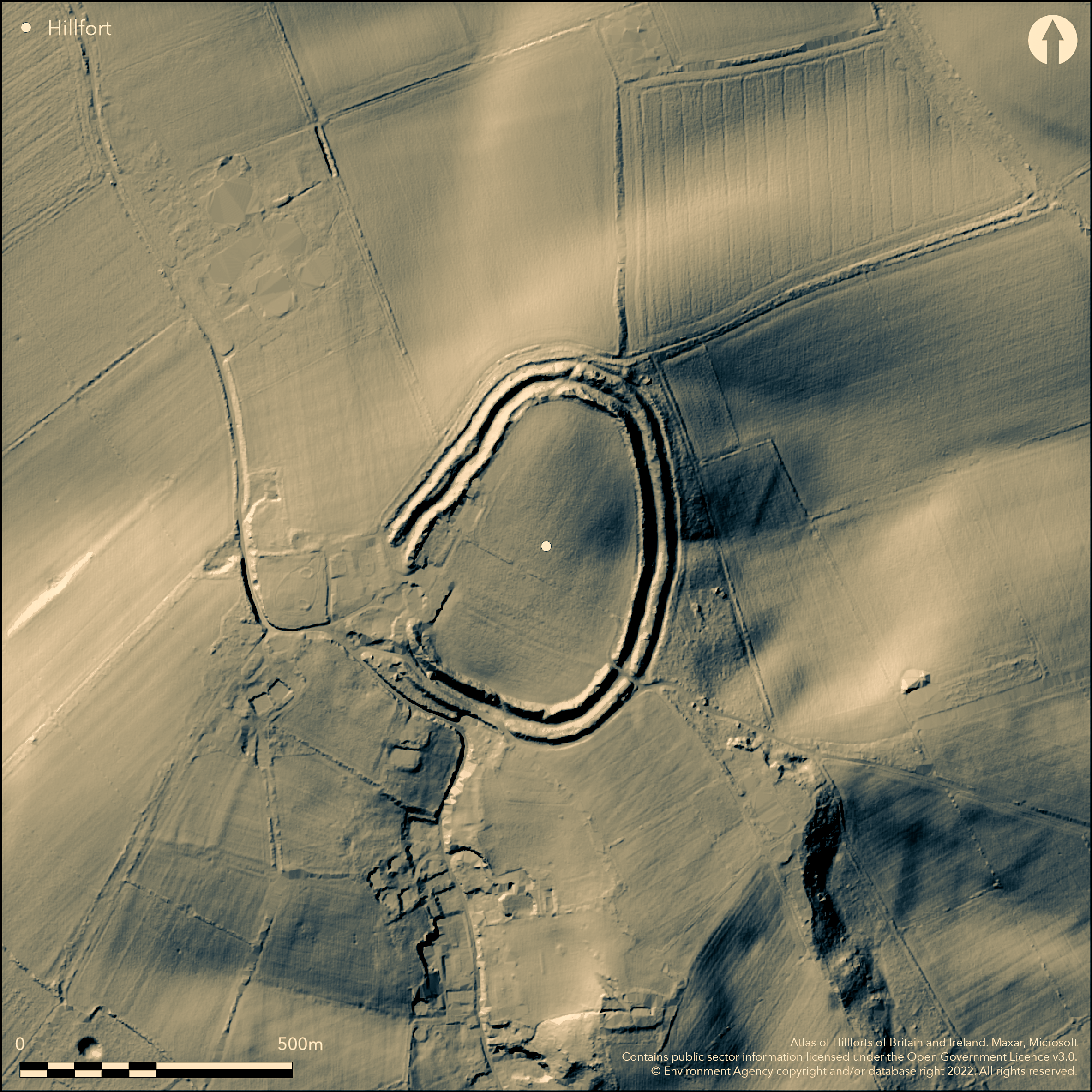
LiDAR 1m DTM Hillshade
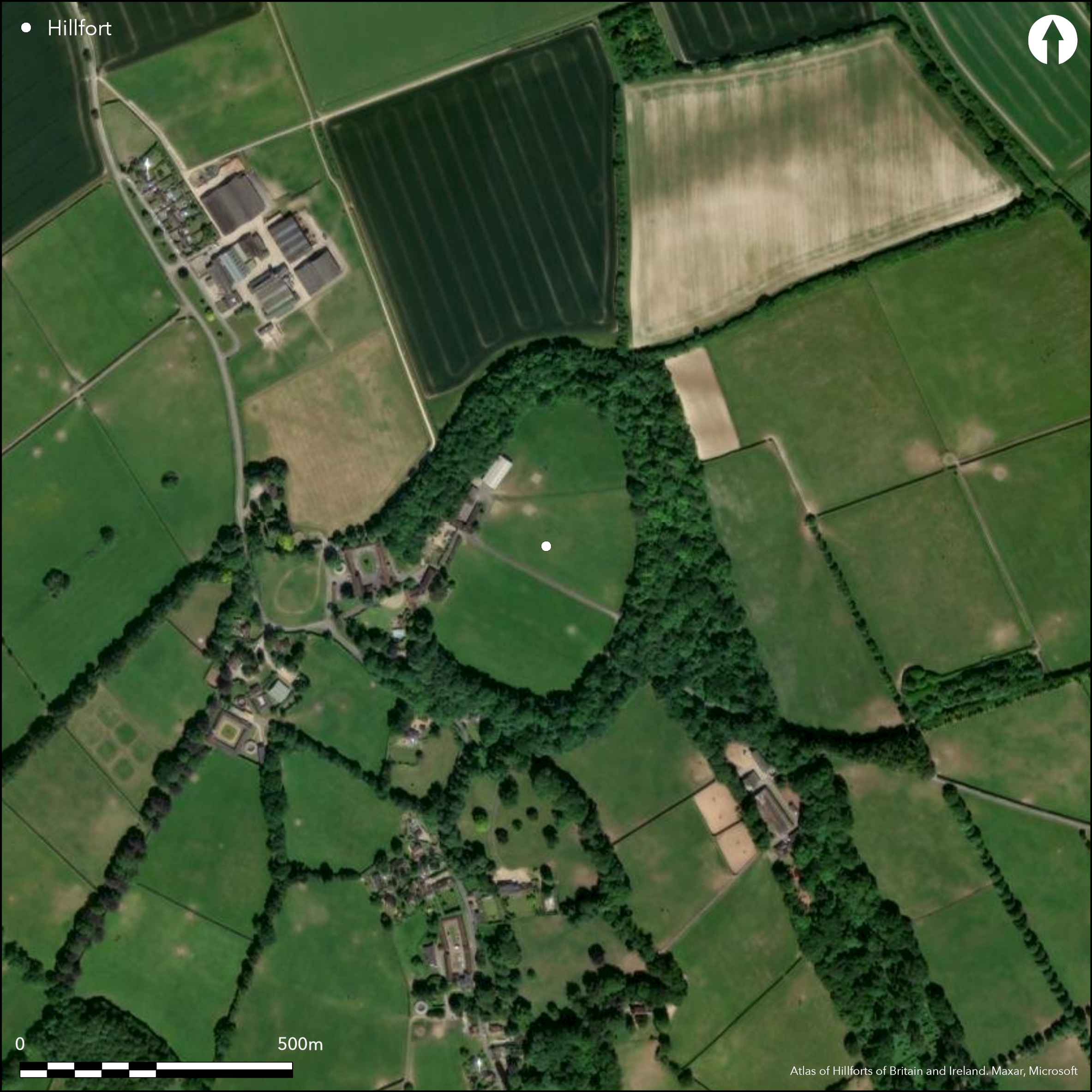
Satellite Imagery
LiDAR 1m DTM Hillshade
Satellite Imagery
Scroll left/right to view further images.
HER: Hampshire 21475 (None)
NMR: SU 11 NW 2 (217258)
SM: 1020316
NGR: SU 1280 1968
X: 412800 Y: 119680 (OSGB36)
Multivallate countour hillfort located on high chalk outcrop projecting N from Whitsbury village and c. 4km W of River Avon. Moderate to strong to steep surrounding slopes, moderate in part to SE and SW. Roughly N-S aligned, pear-shaped, flat and moderately sloping interior of 6.3ha. Substantial defences enclose the hill except on SW side where destroyed by manor house. Comprises two ramparts separated by two ditches, and counterscarp. Inner rampart to 2m-3m above interior and 4m-6m above ditches, as does second bank. Counterscarp slight by comparison, part destroyed on SE and SW where adjoining ridges located giving easiest access to hill top. No definite original entrance visible - possibly where manor house stands on W, however another possibility is on N where outer rampart opens at its extremity, flanked to E by mound which may be potential guard chamber - pure speculation. Elsewhere modern gaps on NE and SE. Interior damaged by manor house buildings and associated stables, walled garden and water reservoirs. Excavation 1960-61 (Elison and Rahtz 1987) for Ministry of Public Building and Works, showed inner rampart originally constructed in early Iron Age (6th-5th centuries BC), remained in use to, at least, middle Iron Age (4th-1st centuries BC). Also foundations timber house constructed during this later period and pottery and other domestic items. Roman pottery, also found. Unusually, in post-Roman or early Saxon period, 6th or 7th centuries AD, defences refurbished. Importance of site later still in in 16th to 18th centuries as a boundary marker shown by earthwork bank which partly overlies N defences, where projects to NE for c. 75m. In 1810 Colt Hoare noted site to be 'much obscured by copse wood'. Interior damaged by the manor house buildings and associated stables, walled garden and water reservoirs. Ploughed in past. Parkland/pasture interior, wooded surrounds. On OS map (1891).
Citizen Science: ✓
Reliability of Data: Confirmed
Reliability of Interpretation: Confirmed
X: -202498 Y: 6617108 (EPSG: 3857)
Longitude: -1.819072203411793 Latitude: 50.976330735185535 (EPSG:4326)
Country: England; None
Current County or Unitary Authority: Hampshire
Historic County: Hampshire and Isle of Wight
Current Parish/Community/Council/Townland: Whitsbury; Rockbourne; Breamore
Defences enclose the hill except on SW side where destroyed by manor house. Interior damaged by the manor house buildings and associated stables, walled garden and water reservoirs. Ploughed in past.
| Extant | ✓ |
| Cropmark | ✗ |
| Likely Destroyed | ✓ |
Parkland/pasture interior, wooded surrounds.
| Woodland | ✓ |
| Commercial Forestry Plantation | ✗ |
| Parkland | ✓ |
| Pasture (Grazing) | ✓ |
| Arable | ✗ |
| Scrub/Bracken | ✗ |
| Bare Outcrop | ✗ |
| Heather/Moorland | ✗ |
| Heath | ✗ |
| Built-up | ✗ |
| Coastal Grassland | ✗ |
| Other | ✗ |
Multivallate countour hillfort located on high chalk outcrop projecting N from Whitsbury village and c. 4km W of River Avon. Moderate to strong to steep surrounding slopes, moderate in part to SE and SW.
| Contour Fort | ✓ |
| Partial Contour Fort | ✗ |
| Promontory Fort | ✗ |
| Hillslope Fort | ✗ |
| Level Terrain Fort | ✗ |
| Marsh Fort | ✗ |
| Multiple Enclosure Fort | ✗ |
| Hilltop | ✓ |
| Coastal Promontory | ✗ |
| Inland Promontory | ✗ |
| Valley Bottom | ✗ |
| Knoll/Hillock/Outcrop | ✓ |
| Ridge | ✗ |
| Cliff/Plateau-edge/Scarp | ✗ |
| Hillslope | ✗ |
| Lowland | ✗ |
| Spur | ✗ |
Dominant Topographic Feature: Chalk outcrop.
| North | ✗ |
| Northeast | ✗ |
| East | ✗ |
| Southeast | ✗ |
| South | ✗ |
| Southwest | ✗ |
| West | ✗ |
| Northwest | ✗ |
| Level | ✓ |
Altitude: 123.0m
Boundary Type: Parish/Townland
Excavation in 1960 found evidence of almost continuous interest in hill and/or use since the Mesolithic period. Hillfort rampart originally constructed in early Iron Age (6th-5th centuries BC), remained in use to, at least, middle Iron Age (4th-1st centuries BC). Also foundations timber house constructed during this later period and early and middle Iron Age pottery and other domestic items. Unusually, in post-Roman or early Saxon period, 6th or 7th centuries AD, defences refurbished.
Reliability: B - Medium
| Pre 1200BC | ✗ |
| 1200BC - 800BC | ✗ |
| 800BC - 400BC | ✓ |
| 400BC - AD50 | ✓ |
| AD50 - AD400 | ✗ |
| AD400 - AD 800 | ✗ |
| Post AD800 | ✗ |
| Unknown | ✗ |
| Pre Hillfort: | None |
| Post Hillfort: | None |
| Artefactual: | Early and middle Iron Age pottery and other domestic items. |
| Morphology/Earthwork/Typology: | Defences refurbished in post-Roman or early Saxon period. |
In Aubrey's Monumenta Britannica (1665-1693). In 1810 Colt Hoare noted site to be 'much obscured by copse wood'. On 1st Ed. OS map (1871). Field investigator comments 1953, 1954, 1969, 1982. Excavation P.A. Rahtz, Ministry of Public Building and Works 1960-1. New Forest NPA LiDar survey - Citizen Science 2015.
| 1st Identified Map Depiction (1871): | OS map. |
| LiDAR Survey (2015): | New Forest NPA. |
| 1st Identified Written Reference (None): | In Aubrey's Monumenta Britannica. |
| Other (None): | Field investigator comments - no details. |
| Excavation (None): | P.A. Rahtz, Ministry of Public Building and Works. |
Middle Iron Age timber house, pottery and other domestic items.
None
| None | ✓ |
| Spring | ✗ |
| Stream | ✗ |
| Pool | ✗ |
| Flush | ✗ |
| Well | ✗ |
| Other | ✗ |
None
| No Known Features | ✓ |
| Round Stone Structures | ✗ |
| Rectangular Stone Structures | ✗ |
| Curvilinear Platforms | ✗ |
| Other Roundhouse Evidence | ✗ |
| Pits | ✗ |
| Quarry Hollows | ✗ |
| Other | ✗ |
Foundations of Middle Iron Age timber roundhouse, A circular house, 7.6m diameter, with hearth, postholes and drainage pit or ditch excavated near N defences where stable block now stands.
| No Known Excavation | ✗ |
| Pits | ✗ |
| Postholes | ✗ |
| Roundhouses | ✓ |
| Rectangular Structures | ✗ |
| Roads/Tracks | ✗ |
| Quarry Hollows | ✗ |
| Other | ✓ |
| Nothing Found | ✗ |
None
| No Known Geophysics | ✓ |
| Pits | ✗ |
| Roundhouses | ✗ |
| Rectangular Structures | ✗ |
| Roads/Tracks | ✗ |
| Quarry Hollows | ✗ |
| Other | ✗ |
| Nothing Found | ✗ |
Middle Iron Age pottery and iron objects.
| No Known Finds | ✗ |
| Pottery | ✓ |
| Metal | ✓ |
| Metalworking | ✗ |
| Human Bones | ✗ |
| Animal Bones | ✗ |
| Lithics | ✗ |
| Environmental | ✗ |
| Other | ✗ |
None
| APs Not Checked | ✓ |
| None | ✗ |
| Roundhouses | ✗ |
| Rectangular Structures | ✗ |
| Pits | ✗ |
| Postholes | ✗ |
| Roads/Tracks | ✗ |
| Other | ✗ |
No definite original entrance visible - possibly where manor house stands on W, however another possibility is on N where outer rampart opens at its extremity, flanked to E by mound which may be potential guard chamber - pure speculation. Elsewhere modern gaps on N and SE, but latter speculated as original in past.
| None: | Total not defined - modern gaps on NE and SE, but latter speculated as original in past. |
| 2: | Possible sites only. |
Guard Chambers: ✓
Chevaux de Frise: ✗
| 1. Simple Gap (West): | Possible site only where manor house now stands. Simple gap default. |
| 2. Simple Gap (North): | Possibly where outer rampart opens at its N extremity, |
| 2. Recesses/Guard Chambers (North): | Possible entrance on N where outer rampart opens at its extremity, flanked to E by mound which may be potential guard chamber - pure speculation. |
Substantial defences enclose the hill except on SW side where destroyed by manor house. Comprise two ramparts separated by two ditches, and counterscarp. Inner rampart to 2m-3m above interior and 4m-6m above ditches, as does second bank. Counterscarp slight by comparison, part destroyed on SE and SW where adjoining ridges located giving easiest access to hill top.
| Area 1: | 6.3ha. |
| Total: | 6.3ha. |
Total Footprint Area: Noneha.
None
| ✓ | Defences refurbished post-Roman or early Saxon period. |
| ✗ | Ramparts destroyed by manor house on SW. |
| NE Quadrant: | 2 |
| SE Quadrant: | 2 |
| SW Quadrant: | 0 |
| NW Quadrant: | 2 |
| Total: | 2 |
| Partial Univallate | ✗ |
| Univallate | ✗ |
| Partial Bivallate | ✓ |
| Bivallate | ✗ |
| Partial Multivallate | ✗ |
| Multivallate | ✗ |
| Unknown | ✗ |
| Partial Univallate | ✗ |
| Univallate | ✗ |
| Partial Bivallate | ✗ |
| Bivallate | ✗ |
| Partial Multivallate | ✗ |
| Multivallate | ✗ |
Counterscarp slight by comparison to main banks, part destroyed on SE and SW.
| None | ✗ |
| Earthen Bank | ✓ |
| Stone Wall | ✗ |
| Rubble | ✗ |
| Wall-walk | ✗ |
| Evidence of Timber | ✗ |
| Vitrification | ✗ |
| Other Burning | ✗ |
| Palisade | ✗ |
| Counter Scarp Bank | ✓ |
| Berm | ✗ |
| Unfinished | ✗ |
| Other | ✗ |
Excavation showed rampart dating.
| None | ✗ |
| Earthen Bank | ✓ |
| Stone Wall | ✗ |
| Murus Duplex | ✗ |
| Timber-framed | ✗ |
| Timber-laced | ✗ |
| Vitrification | ✗ |
| Other Burning | ✗ |
| Palisade | ✗ |
| Counter Scarp Bank | ✗ |
| Berm | ✗ |
| Unfinished | ✗ |
| No Known Excavation | ✗ |
| Other | ✗ |
| ✗ | None |
| ✓ | None |
Number of Ditches: 2
| ✗ | None |
Elison, A. and Rahtz, P.A. 1987. Excavations at Whitsbury Castle Ditches, Hampshire, 1960, Proc Hampshire Fld Club Archaeol Soc, 43, 63-81.
Sumner, H. 1913. The ancient earthworks of Cranborne Chase, 20-22.
Williams-Freeman, J.P. 1915. An introduction to field archaeology as illustrated by Hampshire, London: Macmillan and Co Ltd, 418.
Atlas of Hillforts:
Wikidata:
This work is licensed under CC BY-SA 4.0

 and should be cited as:
Lock, Gary and Ralston, Ian. 2024. Atlas of Hillforts of Britain and Ireland. Available at: https://hillforts.arch.ox.ac.uk
Document Version 1.1