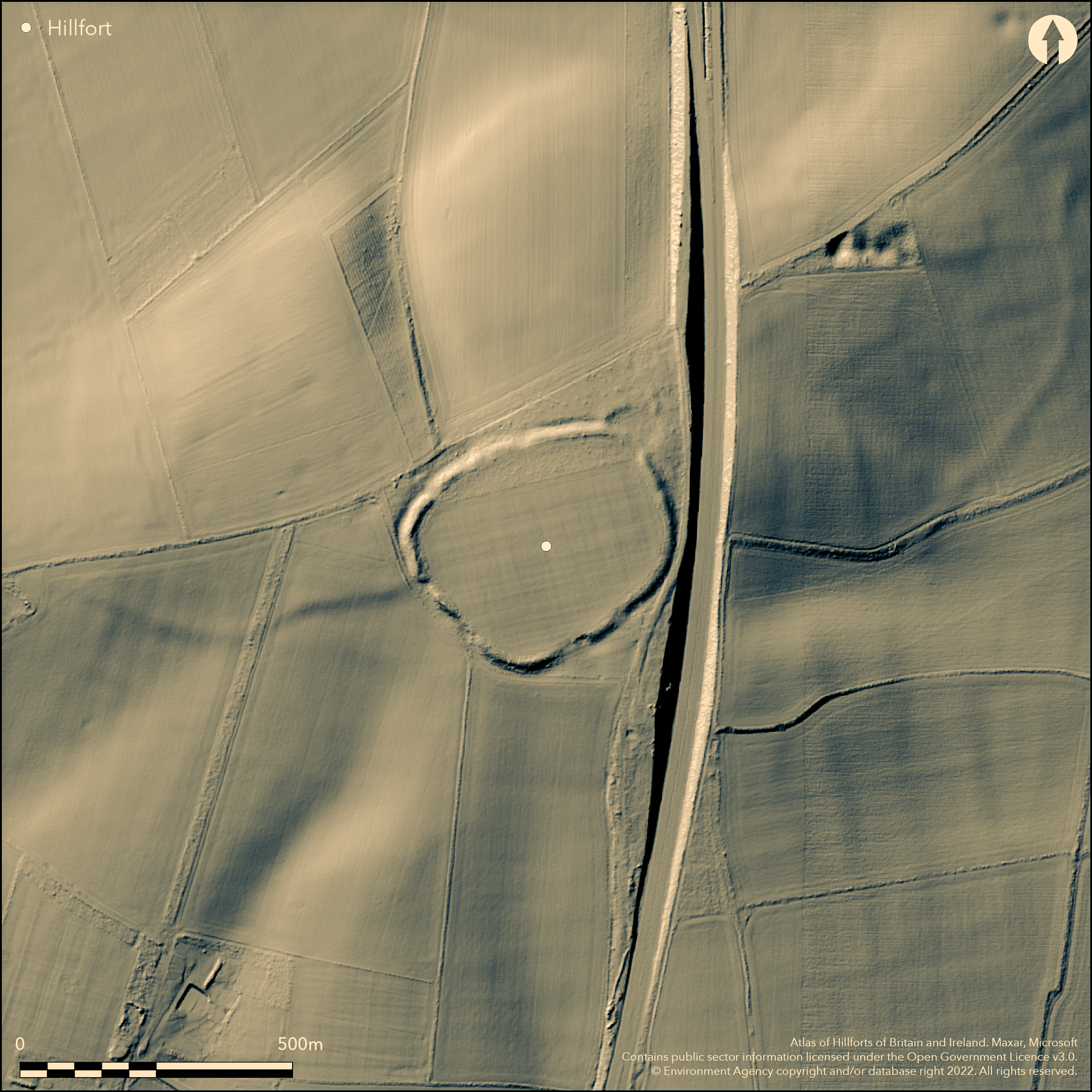
LiDAR 1m DTM Hillshade
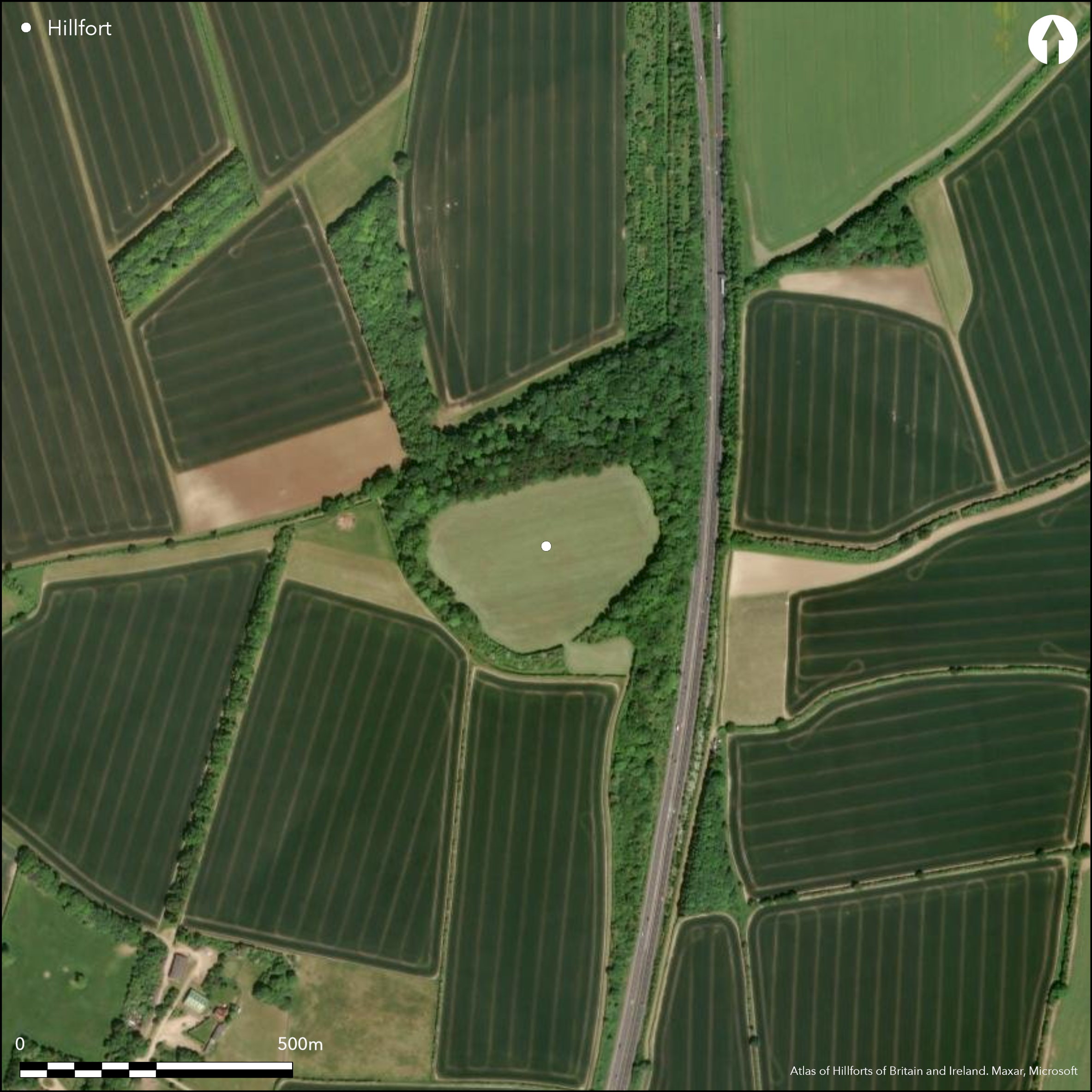
Satellite Imagery
LiDAR 1m DTM Hillshade
Satellite Imagery
Scroll left/right to view further images.
HER: Hampshire 17739 (None)
NMR: SU 44 SE 4 (232181)
SM: 1001950
NGR: SU46284292
X: 446280 Y: 142920 (OSGB36)
Univallate contour hillfort, located on prominent NE-SW ridge above River Test valley on W. Steep surrounding slopes on E, S and W, moderate along ridge on NE. Circular shape, with internal area 5.26ha. Defined by rampart 1.5m-2.4m high, except on N where ploughed-out. Ditch shows as broad depression c. 0.3m deep. Possible entrance on SE shows as wide gap in defence. Small excavation 1927 (no details). Two rectangular buildings visible as cropmarks in interior possibly Roman aisled house or temple complex (Wilson 1974), with two lines of post-bases dividing nave and aisles. Probable hillfort abandoned when villa established. Another possibility is that the buildings are a temple-complex. Pasture interior, wooded bank and surrounds. On 1st Ed. OS map (1871-81). Undated.
Citizen Science: ✗
Reliability of Data: Confirmed
Reliability of Interpretation: Confirmed
X: -149084 Y: 6653832 (EPSG: 3857)
Longitude: -1.3392405547098367 Latitude: 51.18358605888507 (EPSG:4326)
Country: England; None
Current County or Unitary Authority: Hampshire
Historic County: Hampshire and Isle of Wight
Current Parish/Community/Council/Townland: Bullington; Longparish
Damaged. N ploughed-out.
| Extant | ✓ |
| Cropmark | ✗ |
| Likely Destroyed | ✗ |
Pasture interior, wooded bank and surrounds.
| Woodland | ✓ |
| Commercial Forestry Plantation | ✗ |
| Parkland | ✗ |
| Pasture (Grazing) | ✓ |
| Arable | ✗ |
| Scrub/Bracken | ✗ |
| Bare Outcrop | ✗ |
| Heather/Moorland | ✗ |
| Heath | ✗ |
| Built-up | ✗ |
| Coastal Grassland | ✗ |
| Other | ✗ |
Contour fort on prominent hilltop.
| Contour Fort | ✓ |
| Partial Contour Fort | ✗ |
| Promontory Fort | ✗ |
| Hillslope Fort | ✗ |
| Level Terrain Fort | ✗ |
| Marsh Fort | ✗ |
| Multiple Enclosure Fort | ✗ |
| Hilltop | ✗ |
| Coastal Promontory | ✗ |
| Inland Promontory | ✗ |
| Valley Bottom | ✗ |
| Knoll/Hillock/Outcrop | ✗ |
| Ridge | ✓ |
| Cliff/Plateau-edge/Scarp | ✗ |
| Hillslope | ✗ |
| Lowland | ✗ |
| Spur | ✗ |
Dominant Topographic Feature: Ridge
| North | ✗ |
| Northeast | ✗ |
| East | ✗ |
| Southeast | ✗ |
| South | ✗ |
| Southwest | ✗ |
| West | ✗ |
| Northwest | ✗ |
| Level | ✓ |
Altitude: 113.0m
Boundary Type: Parish/Townland
None.
Reliability: D - None
| Pre 1200BC | ✗ |
| 1200BC - 800BC | ✗ |
| 800BC - 400BC | ✗ |
| 400BC - AD50 | ✗ |
| AD50 - AD400 | ✗ |
| AD400 - AD 800 | ✗ |
| Post AD800 | ✗ |
| Unknown | ✓ |
| Pre Hillfort: | None |
| Post Hillfort: | Two rectangular buildings visible as cropmarks in interior possibly Roman aisled house or temple complex (Wilson 1974), with two lines of post-bases dividing nave and aisles. Probable hillfort abandoned when villa established. Roman building material and two coins of Constantine (306-337 AD) found. |
In Aubrey's Monumenta Britannica (1665-1693). On 1st Ed. OS map (1871-81). Excavation Rev. A.B. Milner 1927. Field investigator comments 1955, 1967.
| Excavation (1927): | Rev. A.B. Milner. |
| 1st Identified Written Reference (None): | In Aubrey's Monumenta Britannica. |
| 1st Identified Map Depiction (None): | OS map. |
| Other (None): | Field investigator comments - no details. |
Potboilers and Samian sherd.
None
| None | ✓ |
| Spring | ✗ |
| Stream | ✗ |
| Pool | ✗ |
| Flush | ✗ |
| Well | ✗ |
| Other | ✗ |
Two rectangular buildings visible as cropmarks in interior possibly Roman aisled house or temple complex (Wilson 1974), with two lines of post-bases dividing nave and aisles.
| No Known Features | ✗ |
| Round Stone Structures | ✗ |
| Rectangular Stone Structures | ✓ |
| Curvilinear Platforms | ✗ |
| Other Roundhouse Evidence | ✗ |
| Pits | ✗ |
| Quarry Hollows | ✗ |
| Other | ✗ |
No details.
| No Known Excavation | ✗ |
| Pits | ✗ |
| Postholes | ✗ |
| Roundhouses | ✗ |
| Rectangular Structures | ✗ |
| Roads/Tracks | ✗ |
| Quarry Hollows | ✗ |
| Other | ✓ |
| Nothing Found | ✗ |
None
| No Known Geophysics | ✓ |
| Pits | ✗ |
| Roundhouses | ✗ |
| Rectangular Structures | ✗ |
| Roads/Tracks | ✗ |
| Quarry Hollows | ✗ |
| Other | ✗ |
| Nothing Found | ✗ |
Potboilers and Samian sherd.
| No Known Finds | ✗ |
| Pottery | ✓ |
| Metal | ✗ |
| Metalworking | ✗ |
| Human Bones | ✗ |
| Animal Bones | ✗ |
| Lithics | ✓ |
| Environmental | ✗ |
| Other | ✗ |
None
| APs Not Checked | ✓ |
| None | ✗ |
| Roundhouses | ✗ |
| Rectangular Structures | ✗ |
| Pits | ✗ |
| Postholes | ✗ |
| Roads/Tracks | ✗ |
| Other | ✗ |
Possible entrance on SE shows as wide gap in defence.
| 1: | None |
| 2: | None |
Guard Chambers: ✗
Chevaux de Frise: ✗
| 1. Simple Gap (South east): | Wide gap. |
Defined by rampart 1.5m-2.4m high, excaept on N where ploughed-out. Ditch shows as broad depression c. 0.3m deep.
| Area 1: | 5.26ha. |
| Total: | 5.26ha. |
Total Footprint Area: Noneha.
None
| ✗ | None |
| ✗ | None |
| NE Quadrant: | 0 |
| SE Quadrant: | 1 |
| SW Quadrant: | 1 |
| NW Quadrant: | 0 |
| Total: | 1 |
| Partial Univallate | ✓ |
| Univallate | ✗ |
| Partial Bivallate | ✗ |
| Bivallate | ✗ |
| Partial Multivallate | ✗ |
| Multivallate | ✗ |
| Unknown | ✗ |
| Partial Univallate | ✗ |
| Univallate | ✗ |
| Partial Bivallate | ✗ |
| Bivallate | ✗ |
| Partial Multivallate | ✗ |
| Multivallate | ✗ |
None
| None | ✗ |
| Earthen Bank | ✓ |
| Stone Wall | ✗ |
| Rubble | ✗ |
| Wall-walk | ✗ |
| Evidence of Timber | ✗ |
| Vitrification | ✗ |
| Other Burning | ✗ |
| Palisade | ✗ |
| Counter Scarp Bank | ✗ |
| Berm | ✗ |
| Unfinished | ✗ |
| Other | ✗ |
No details.
| None | ✗ |
| Earthen Bank | ✗ |
| Stone Wall | ✗ |
| Murus Duplex | ✗ |
| Timber-framed | ✗ |
| Timber-laced | ✗ |
| Vitrification | ✗ |
| Other Burning | ✗ |
| Palisade | ✗ |
| Counter Scarp Bank | ✗ |
| Berm | ✗ |
| Unfinished | ✗ |
| No Known Excavation | ✗ |
| Other | ✓ |
| ✗ | None |
| ✓ | Ditch shows as broad depression c. 0.3m deep. |
Number of Ditches: 1
| ✗ | None |
Milner, A.B. 1944. Some earthworks in mid-Hampshire, Proc Hampshire Fld Club Archaeol Soc, 16 1944-6, 38-47.
Wilson, D.R. 1974. Romano-British Villas from the air, Britannia,5 252-3, 259.
Williams-Freeman, J.P. 1915. An introduction to field archaeology as illustrated by Hampshire, London: Macmillan and Co Ltd, 418.
Atlas of Hillforts:
Wikidata:
This work is licensed under CC BY-SA 4.0

 and should be cited as:
Lock, Gary and Ralston, Ian. 2024. Atlas of Hillforts of Britain and Ireland. Available at: https://hillforts.arch.ox.ac.uk
Document Version 1.1