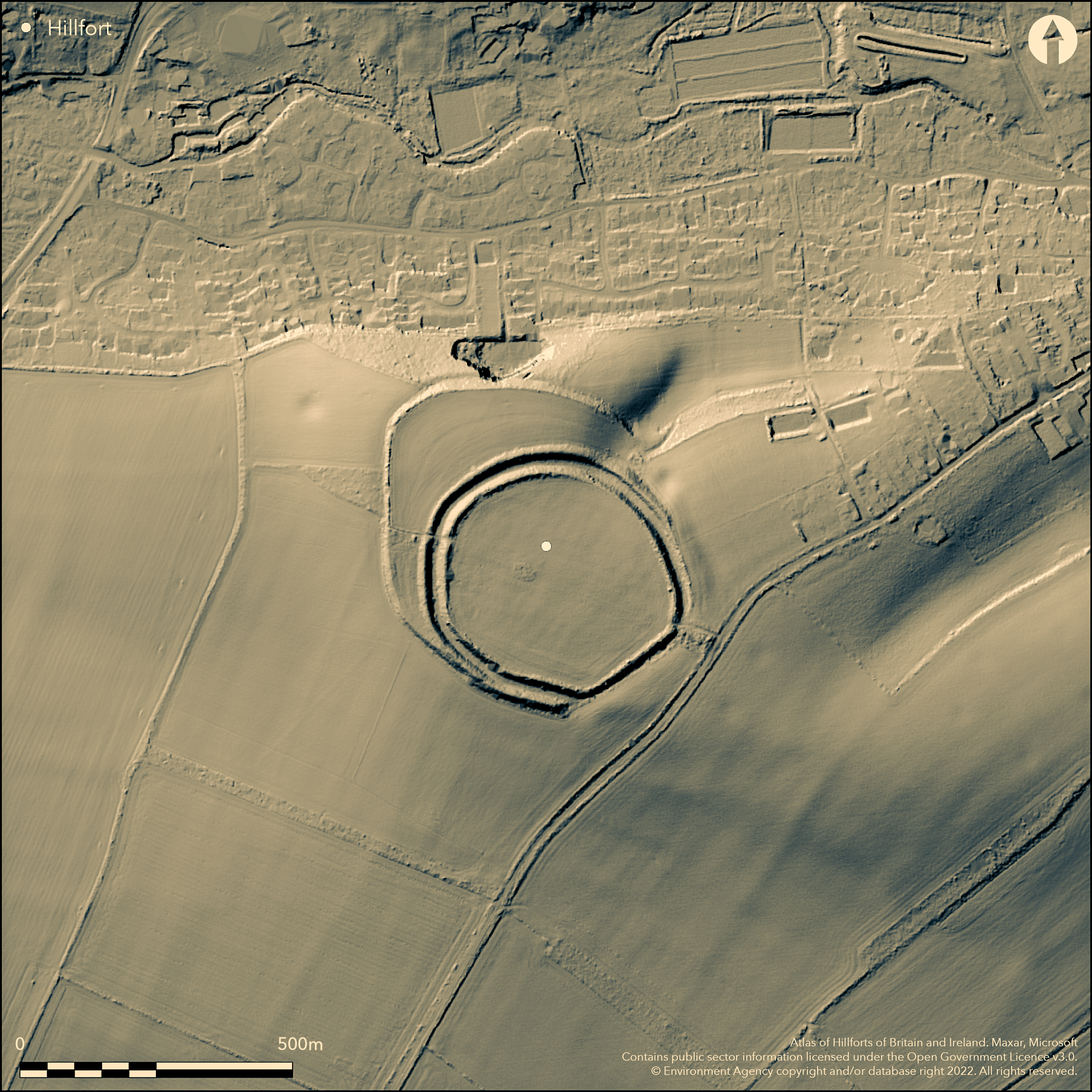
LiDAR 1m DTM Hillshade
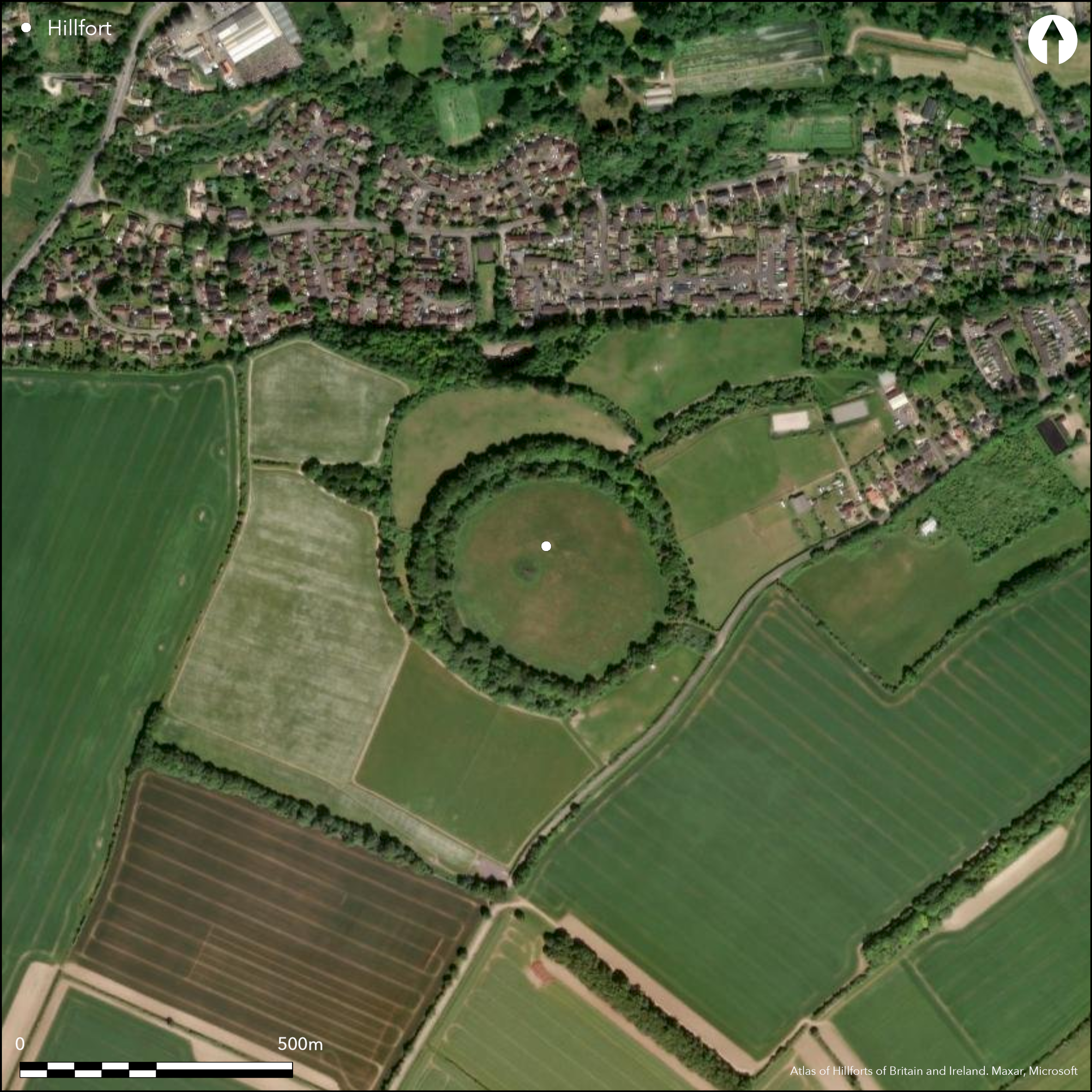
Satellite Imagery
LiDAR 1m DTM Hillshade
Satellite Imagery
Scroll left/right to view further images.
HER: Hampshire 21815 (None)
NMR: SU 34 SW 6 (228306)
SM: 1001951
NGR: SU34574358
X: 434570 Y: 143580 (OSGB36)
Complex and unusual, large contour hillfort located on gentle Upper Cretaceous Chalk hill overlooking confluence of River Anton and River Anna (Pillhill Brook), tributaries of River Test at Upper Clatford. Moderate to strong surrounding slopes, very steep on through woodland on N. Balksbury (Atlas No 3833) less than 1km to N. Egg-shaped, earlier, univallate hillfort, enclosing 9.8ha, later developing into second, approximately circular, but with some straight sections, bivallate earthwork, enclosing 4.75ha, superimposed on S and E sections of earlier enclosures. Earlier fort has single, timber-revetted, chalk bank and external ditch, only visible now as scarp to c. 2.4m high to N and W of the later bivallate fort. Partial excavation showed ditch survives as buried feature 3.5m deep with flat bottom c. 0.75m wide and 6.1m wide at top. The succeeding, and partially overlying on S and E, bivallate fort, has an inner bank, massive ditch and outer bank. Inner bank c. 2.4m above interior and 5.5m above ditch and outer bank c. 4.25m above ditch bottom and 2.1m above exterior. In places inner bank higher than outer. Partial excavation shows ditch partly survives as buried feature and 5.2m deep. Entrance of earlier fort uncertain. Later fort has simple gap entrance on SE, where ramparts of the two enclosures are coincidental, with another possible blocked entrance on NW. Well-researched site and part excavated (Hawkes 1940; Cunliffe and Poole 2000) with geophysical survey 1990 and 1997 (Payne et. al. 2006). Interior of later enclosure densely packed with pits, with horse harness and trappings, but no carbonised grain or human remains as at neighbouring Danebury (Atlas No 3828), suggesting a highly specialised focus in the middle and late Iron Age. These pits shown by geophysics to be noticeably absent from earlier enclosure. and indeed only features excavated here were three small postholes. In later fort the magnetometer survey also found ditches, trackway crossing the interior and connecting the two entrances on SE and possible NW, and possible guard or look-out post just inside SE entrance. Pottery assemblages indicate earlier enclosure 5th and 3rd centuries BC date and later work to 2nd and 1st centuries BC, and possibly into 1st century AD. Just beyond SE entrance, cluster of features including 1.6ha enclosure linear and antennae ditches, but absence of nearby field systems. Pasture interior, wooded banks. On 1st Ed. OS map (1873). This site is included in the Re-dating Danebury Project which is underway at this time of writing (2015). This will provide an independent chronology for Danebury and related Danebury Environs sites which may change the dating recorded here (Haselgrove et. al. Forthcoming).
Citizen Science: ✗
Reliability of Data: Confirmed
Reliability of Interpretation: Confirmed
X: -167726 Y: 6655033 (EPSG: 3857)
Longitude: -1.5067121993171548 Latitude: 51.19034684710981 (EPSG:4326)
Country: England; None
Current County or Unitary Authority: Hampshire
Historic County: Hampshire and Isle of Wight
Current Parish/Community/Council/Townland: Upper Clatford; Abbotts Ann
Some damage to earthworks by modern activity and ditches buried features.,
| Extant | ✓ |
| Cropmark | ✗ |
| Likely Destroyed | ✗ |
Pasture interior, wooded banks.
| Woodland | ✓ |
| Commercial Forestry Plantation | ✗ |
| Parkland | ✗ |
| Pasture (Grazing) | ✓ |
| Arable | ✗ |
| Scrub/Bracken | ✗ |
| Bare Outcrop | ✗ |
| Heather/Moorland | ✗ |
| Heath | ✗ |
| Built-up | ✗ |
| Coastal Grassland | ✗ |
| Other | ✗ |
Complex and unusual, large contour hillfort located on gentle Upper Cretaceous Chalk hill overlooking confluence of River Anton and Pillhill Brook, tributaries of River Test. Moderate to strong surrounding slopes, very steep on through woodland on N.
| Contour Fort | ✓ |
| Partial Contour Fort | ✗ |
| Promontory Fort | ✗ |
| Hillslope Fort | ✗ |
| Level Terrain Fort | ✗ |
| Marsh Fort | ✗ |
| Multiple Enclosure Fort | ✗ |
| Hilltop | ✓ |
| Coastal Promontory | ✗ |
| Inland Promontory | ✗ |
| Valley Bottom | ✗ |
| Knoll/Hillock/Outcrop | ✗ |
| Ridge | ✗ |
| Cliff/Plateau-edge/Scarp | ✗ |
| Hillslope | ✗ |
| Lowland | ✗ |
| Spur | ✗ |
Dominant Topographic Feature: Hill top
| North | ✗ |
| Northeast | ✗ |
| East | ✗ |
| Southeast | ✗ |
| South | ✗ |
| Southwest | ✗ |
| West | ✗ |
| Northwest | ✗ |
| Level | ✓ |
Altitude: 82.0m
Boundary Type: Parish/Townland
Haematite coated pottery from earlier enclosure suggesting middle Iron Age 5th to 3rd century date. In later enclosure assemblage dominated by saucepan pots of late Iron Age 2nd to 1st century BC. C14 dates. This site is included in the Re-dating Danebury Project which is underway at this time of writing (2015). This will provide an independent chronology for Danebury and related Danebury Environs sites which may change the dating recorded here (Haselgrove et. al. Forthcoming).
Reliability: A - High
| Pre 1200BC | ✗ |
| 1200BC - 800BC | ✗ |
| 800BC - 400BC | ✓ |
| 400BC - AD50 | ✓ |
| AD50 - AD400 | ✗ |
| AD400 - AD 800 | ✗ |
| Post AD800 | ✗ |
| Unknown | ✗ |
| Pre Hillfort: | None |
| Post Hillfort: | None |
| Artefactual: | Haematite coated pottery from earlier enclosure suggesting middle Iron Age 5th to 3rd century date. In later enclosure assemblage dominated by saucepan pots of late Iron Age 2nd to 1st century BC. |
| C14: | Fifteen C14 dates, 200 BC to 120/100 BC. |
In Aubrey's Monumenta Britannica (1665-1693). On 1st Ed. OS map (1873). Excavated by C.F.C. and J. Hawkes 1939. Geophysical survey AML, Danebury Environs Project. 1990. Excavation, B. W. Cunliffe, Danebury Environs Project. Geophysical survey part of Wessex Hillforts Project 1997.
| 1st Identified Map Depiction (1873): | OS map. |
| Excavation (1939): | C.F.C. and J. Hawkes. |
| Other (1971): | Visited by Hillfort Study Group |
| Geophysical Survey (1990): | AML |
| Geophysical Survey (1997): | Wessex Hillforts Project. |
Later enclosure densely packed with pits, with horse harness and trappings, but no carbonised grain or human remains as at neighbouring Danebury (Atlas No 3828), suggesting a highly specialised focus. Also trackway crossing the interior and connecting the two entrances on SE and possible NW, and possible guard or look-out post just inside SE entrance. Only features excavated in earlier enclosure were three small postholes. Middle and late Iron Age pottery. Bronze buckle, rotary quern, human and animal bone.
None
| None | ✓ |
| Spring | ✗ |
| Stream | ✗ |
| Pool | ✗ |
| Flush | ✗ |
| Well | ✗ |
| Other | ✗ |
None
| No Known Features | ✓ |
| Round Stone Structures | ✗ |
| Rectangular Stone Structures | ✗ |
| Curvilinear Platforms | ✗ |
| Other Roundhouse Evidence | ✗ |
| Pits | ✗ |
| Quarry Hollows | ✗ |
| Other | ✗ |
Later enclosure found densely packed with pits. Only features excavated in earlier enclosure were three small postholes.
| No Known Excavation | ✗ |
| Pits | ✓ |
| Postholes | ✓ |
| Roundhouses | ✗ |
| Rectangular Structures | ✗ |
| Roads/Tracks | ✗ |
| Quarry Hollows | ✗ |
| Other | ✗ |
| Nothing Found | ✗ |
Later encloure found densely packed with pits, ditches, trackway crossing the interior and connecting the two entrances on SE and possible NW, and possible guard or look-out post just inside SE entrance.
| No Known Geophysics | ✗ |
| Pits | ✓ |
| Roundhouses | ✗ |
| Rectangular Structures | ✗ |
| Roads/Tracks | ✓ |
| Quarry Hollows | ✗ |
| Other | ✗ |
| Nothing Found | ✗ |
Site notable for fine harness and other horse trappings. Bronze buckle. Haematite coated pottery from earlier enclosure suggesting fifth to third century date. In later enclosure assemblage dominated by saucepan pots of second to first century BC. Also rotary quern, human and animal bone.
| No Known Finds | ✗ |
| Pottery | ✓ |
| Metal | ✓ |
| Metalworking | ✗ |
| Human Bones | ✓ |
| Animal Bones | ✓ |
| Lithics | ✓ |
| Environmental | ✗ |
| Other | ✗ |
None
| APs Not Checked | ✓ |
| None | ✗ |
| Roundhouses | ✗ |
| Rectangular Structures | ✗ |
| Pits | ✗ |
| Postholes | ✗ |
| Roads/Tracks | ✗ |
| Other | ✗ |
Entrance of earlier fort uncertain. Later fort has simple gap entrance on SE, where ramparts of the two enclosures are coincidental, with another possible blocked entrance on NW.
| 2: | None |
| 2: | None |
Guard Chambers: ✗
Chevaux de Frise: ✗
| 1. Simple Gap (South east): | None |
| 2. Blocked (North west): | Possible entrance suggested by configuration of earthworks and geophysics and trackway through interior. |
Earlier fort has single, timber-revetted, chalk bank and external ditch, only visible now as scarp to c. 2.4m high to N and W of the later bivallate fort. Partial excavation showed ditch survives as buried feature 3.5m deep with flat bottom c. 0.75m wide and 6.1m wide at top. The succeeding, and partially overlying on S and E, bivallate fort, has an inner bank, massive ditch and outer bank. Inner bank c. 2.4m above interior and 5.5m above ditch and outer bank c. 4.25m above ditch bottom and 2.1m above exterior. In places inner bank higher than outer. Partial excavation shows ditch partly survives as buried feature and 5.2m deep.
| Area 1: | 9.8ha. |
| Area 2: | 4.75ha. |
| Total: | 9.8ha. |
Total Footprint Area: Noneha.
None
| ✓ | Multi-phased site. Earlier univallate hillfort enclosing 9.8ha and second bivallate earthwork enclosing 4.75ha superimposed on S and E sections of earlier defences. |
| ✓ | None |
| NE Quadrant: | 3 |
| SE Quadrant: | 2 |
| SW Quadrant: | 2 |
| NW Quadrant: | 3 |
| Total: | 3 |
| Partial Univallate | ✗ |
| Univallate | ✗ |
| Partial Bivallate | ✓ |
| Bivallate | ✗ |
| Partial Multivallate | ✓ |
| Multivallate | ✗ |
| Unknown | ✗ |
| Partial Univallate | ✗ |
| Univallate | ✓ |
| Partial Bivallate | ✗ |
| Bivallate | ✗ |
| Partial Multivallate | ✗ |
| Multivallate | ✗ |
None
| None | ✗ |
| Earthen Bank | ✓ |
| Stone Wall | ✗ |
| Rubble | ✗ |
| Wall-walk | ✗ |
| Evidence of Timber | ✗ |
| Vitrification | ✗ |
| Other Burning | ✗ |
| Palisade | ✗ |
| Counter Scarp Bank | ✗ |
| Berm | ✗ |
| Unfinished | ✗ |
| Other | ✗ |
Rampart sectioned within earlier outer enclosure following a geophysical survey 1990., finding timber-revetted, chalk bank.
| None | ✗ |
| Earthen Bank | ✓ |
| Stone Wall | ✗ |
| Murus Duplex | ✗ |
| Timber-framed | ✓ |
| Timber-laced | ✗ |
| Vitrification | ✗ |
| Other Burning | ✗ |
| Palisade | ✗ |
| Counter Scarp Bank | ✗ |
| Berm | ✗ |
| Unfinished | ✗ |
| No Known Excavation | ✗ |
| Other | ✗ |
| ✗ | None |
| ✓ | Ditches buried features. |
Number of Ditches: 2
| ✗ | None |
Brown, I. 2009. Beacons in the landscape. The hillforts of England and Wales, Oxford: Windgather Press/Oxbow Books.
Cave, A. J. E, Jackson, J. W. and Zeuner, F. E. 1941. Report on the human remains, etc, from the Bury Hill excavations, 1939, Proc Hampshire Fld Club Archaeol Soc, 51 43-52.
Cunliffe, B.W. and Poole, C. 2000. The Danebury Environs Programme - the prehistory of a Wessex landscape, Vol 2, Part 2 - Bury Hill, Upper Clatford, Hants 1990. Oxford: English Heritage/ Oxford U Committee Archaeol Monograph 49 (Part 2).
Haselgrove, C., Gosden, C., Hamilton, D., Brown, L. and Poole, C. Forthcoming. Iron Age settlement and society in central southern Britain: a new chronological perspective. Oxford: School of Archaeology Monograph.
Hawkes, C.F.C. 1940. The excavations at Bury Hill 1939. Proc Hampshire Fld Club Archaeol Soc, 14, 291-337.
Payne, A, Corney, M. and Cunliffe, B. 2006. The Wessex hillforts project, Extensive survey of hillfort interiors in central southern England. London: English Heritage, 54-58.
Williams-Freeman, J.P. 1915. An introduction to field archaeology as illustrated by Hampshire, London: Macmillan and Co Ltd, 138-40, 363
Atlas of Hillforts:
Wikidata:
This work is licensed under CC BY-SA 4.0

 and should be cited as:
Lock, Gary and Ralston, Ian. 2024. Atlas of Hillforts of Britain and Ireland. Available at: https://hillforts.arch.ox.ac.uk
Document Version 1.1