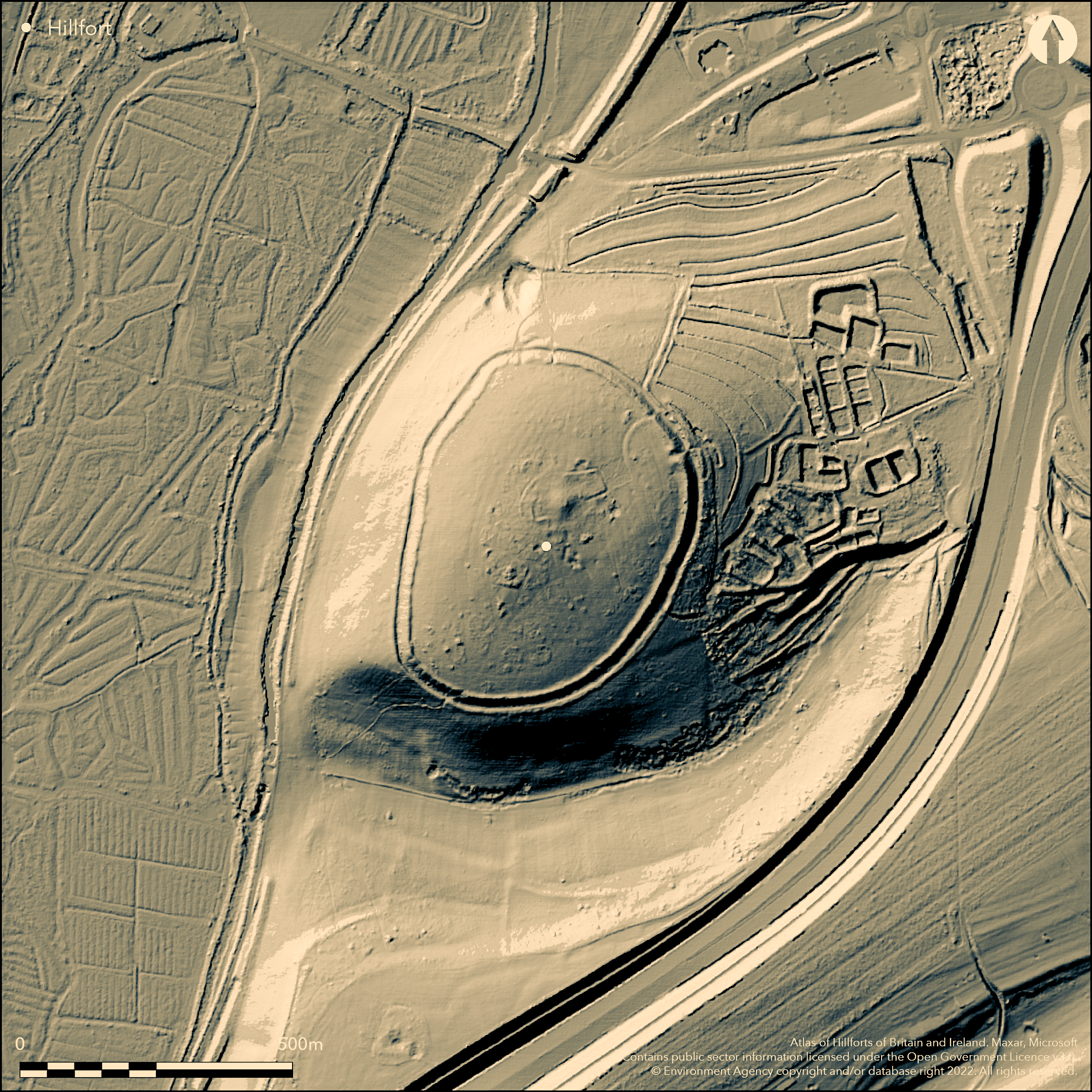
LiDAR 1m DTM Hillshade
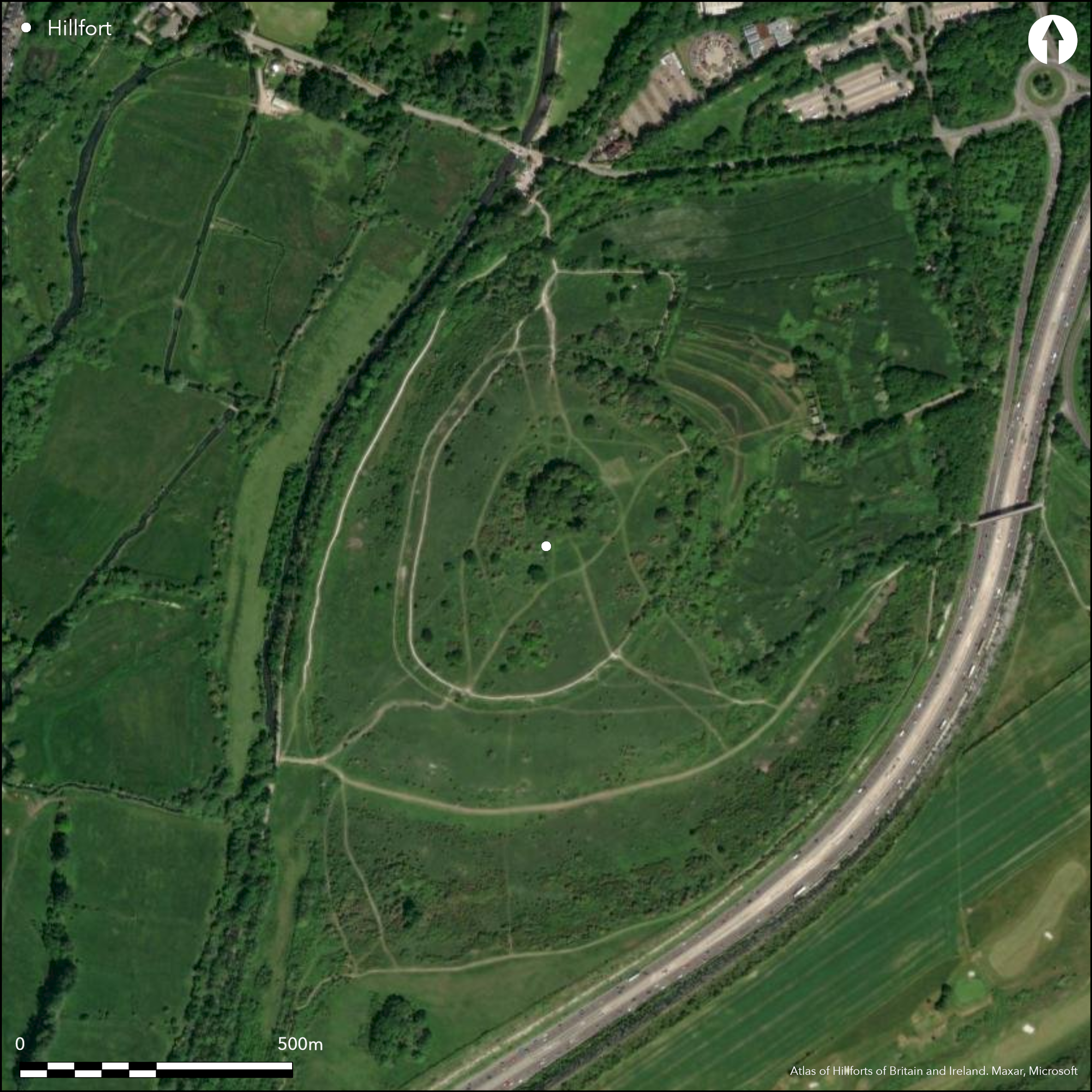
Satellite Imagery
LiDAR 1m DTM Hillshade
Satellite Imagery
Scroll left/right to view further images.
HER: Hampshire 26913 (None)
NMR: SU 42 NE 15 (230614)
SM: 1016489
NGR: SU48402762
X: 448400 Y: 127620 (OSGB36)
Large, univallate, contour hillfort located on steep-sided, rounded, chalk hill above River Itchen and Itchen Navigation Canal to W. Ramparts follow natural contour of hilltop and climb to NE where hill forms a low saddle to Twyford Down to SE. Generally steep surrounding slopes, but very steep on W and less on N and NE. Site forms N-S aligned, oval shaped, interior area of c. 9ha. Single, well-preserved rampart encircles hilltop flanked by outer ditch, with low, ill-defined counterscarp. Inner slope of rampart stronger where slopes less, varying from 0.2m in W to 1.8m. in E. Outer slope of the largely scarping of natural slope, and fairly uniform 6.5 m high. The outer ditch counterscarp bank fades completely to S and NW, where slopes steepest. Ditch varies from 0.4m. deep on W to maximum 1.8 m. on E. Traces of possible second outer ditch on N, but possibly result of quarrying or remnants of a hollow way. To NE original entrance formed by causewayed gap through splayed ends of the counterscarp bank and inturned ends of the ramparts. Part excavations 1925-1928 (Hawkes et. al. 1930; Hawkes 1976) revealed hilltop originally unfortified Iron Age settlement, dated 550-450 BC, before ramparts constructed c. 250-200 BC. Entrance originally revetted with timber and included guard houses set in bays in the ramparts on either side. Then altered during 2nd century BC, narrowing entrance passage and strengthening the revetment with chalk blocks, before site was abandoned at or shortly after 50 BC. Excavations also found pits, ditches and artefacts covering entire occupation of site, with buried remains of later use, with Roman pottery and coins, dated to 1st to 3rd centuries AD and and medieval, Norman style, chapel on summit built prior to middle 12th century and surrounded by number of associated medieval earthworks, including boundary ditches, rubbish pits, chalk extraction pits and possible cemetery. Small post-medieval mizmaze inside entrance. Up to six additional gaps in the defences are the result of more recent tracks and paths. Ditched enclosure to N of site and probable woodland enclosure to E both probably medieval. Fine, well-preserved site under chalk downland pasture, with scattered trees in interior and on bank running N-ESE. Setting affected by Winchester by-pass to E. On 1st Ed. OS map (1873).
Citizen Science: ✗
Reliability of Data: Confirmed
Reliability of Interpretation: Confirmed
X: -145935 Y: 6629406 (EPSG: 3857)
Longitude: -1.3109597471211072 Latitude: 51.04583947309503 (EPSG:4326)
Country: England; None
Current County or Unitary Authority: Hampshire
Historic County: Hampshire and Isle of Wight
Current Parish/Community/Council/Townland: Winchester; Twyford
Fine, well-preserved site. Medieval St Catherine's chapel found by excavation in interior. Setting affected by Winchester by-pass to E.
| Extant | ✓ |
| Cropmark | ✗ |
| Likely Destroyed | ✗ |
Downland pasture, with scattered trees in interior and clump in middle and trees on bank running N to ESE. SSSI. Medieval features.
| Woodland | ✗ |
| Commercial Forestry Plantation | ✗ |
| Parkland | ✗ |
| Pasture (Grazing) | ✓ |
| Arable | ✗ |
| Scrub/Bracken | ✗ |
| Bare Outcrop | ✗ |
| Heather/Moorland | ✗ |
| Heath | ✗ |
| Built-up | ✗ |
| Coastal Grassland | ✗ |
| Other | ✓ |
Large, univallate, contour hillfort located on steep-sided, rounded, chalk hill above River Itchen and Itchen Navigation Canal to W. Defences follow natural contour of hilltop and climb to NE where hill forms a low saddle to Twyford Down to SE. Generally steep surrounding slopes, but very steep on W and less on N and NE.
| Contour Fort | ✓ |
| Partial Contour Fort | ✗ |
| Promontory Fort | ✗ |
| Hillslope Fort | ✗ |
| Level Terrain Fort | ✗ |
| Marsh Fort | ✗ |
| Multiple Enclosure Fort | ✗ |
| Hilltop | ✓ |
| Coastal Promontory | ✗ |
| Inland Promontory | ✗ |
| Valley Bottom | ✗ |
| Knoll/Hillock/Outcrop | ✗ |
| Ridge | ✗ |
| Cliff/Plateau-edge/Scarp | ✗ |
| Hillslope | ✗ |
| Lowland | ✗ |
| Spur | ✗ |
Dominant Topographic Feature: Hill top
| North | ✗ |
| Northeast | ✗ |
| East | ✗ |
| Southeast | ✗ |
| South | ✗ |
| Southwest | ✗ |
| West | ✗ |
| Northwest | ✗ |
| Level | ✓ |
Altitude: 100.0m
Boundary Type: Parish/Townland
Part excavations 1925-28 revealed hilltop originally unfortified Iron Age settlement, dated 550-450 BC, before defences constructed c. 250-200 BC. Entrance originally revetted with timber and included guard houses set in bays in the ramparts on either side. Then altered during 2nd century BC, narrowing entrance passage and strengthening the revetment with chalk blocks, before site was abandoned at or shortly after 50 BC. Excavations also found pits, ditches and artefacts covering entire occupation of site, including early and middle Iron Age pottery, with buried remains of later use, with Roman pottery and coins, dated to 1st to 3rd centuries AD.
Reliability: B - Medium
| Pre 1200BC | ✗ |
| 1200BC - 800BC | ✗ |
| 800BC - 400BC | ✗ |
| 400BC - AD50 | ✓ |
| AD50 - AD400 | ✗ |
| AD400 - AD 800 | ✗ |
| Post AD800 | ✗ |
| Unknown | ✗ |
| Pre Hillfort: | None |
| Post Hillfort: | None |
| Artefactual: | Artefacts covering entire occupation of site. |
In Aubrey's Monumenta Britannica (1665-1693). On 1st Ed. OS map (1873). Part excavation C. Hawkes, C. Stevens and J. Myres 1925-28. Air Photograph Interpretation RCHME, ref. no. 997213: St Catherine's Hill and Twyford Down Project 1987. Magnetometer survey as part of Wessex Hillforts Project 1997.
| 1st Identified Map Depiction (1873): | OS map. |
| Other (1971): | Visited by Hillfort Study Group |
| Other (1987): | Air Photograph Interpretation RCHME: St Catherine's Hill and Twyford Down Project |
| Geophysical Survey (1997): | Wessex Hillforts Project. |
| 1st Identified Written Reference (None): | In Aubrey's Monumenta Britannica. |
| Excavation (None): | C. Hawkes, C. Stevens and J. Myres. |
Only internal features visible are number of small pits as in geophysics. Excavations also found pits, ditches and artefacts covering entire occupation of site, with buried remains of later use, with Roman pottery and coins, dated to first to third centuries AD and late first century fibula.
None
| None | ✓ |
| Spring | ✗ |
| Stream | ✗ |
| Pool | ✗ |
| Flush | ✗ |
| Well | ✗ |
| Other | ✗ |
Only internal features visible on site are number of small pits, possibly medieval for chapel material.
| No Known Features | ✓ |
| Round Stone Structures | ✗ |
| Rectangular Stone Structures | ✗ |
| Curvilinear Platforms | ✗ |
| Other Roundhouse Evidence | ✗ |
| Pits | ✗ |
| Quarry Hollows | ✗ |
| Other | ✗ |
Excavations recovered pits, ditches and artefacts covering the whole range of occupation of site.
| No Known Excavation | ✗ |
| Pits | ✓ |
| Postholes | ✗ |
| Roundhouses | ✗ |
| Rectangular Structures | ✗ |
| Roads/Tracks | ✗ |
| Quarry Hollows | ✗ |
| Other | ✓ |
| Nothing Found | ✗ |
Number of small pits.
| No Known Geophysics | ✗ |
| Pits | ✓ |
| Roundhouses | ✗ |
| Rectangular Structures | ✗ |
| Roads/Tracks | ✗ |
| Quarry Hollows | ✗ |
| Other | ✗ |
| Nothing Found | ✗ |
Artefacts covering entire occupation of site, including early and middle Iron Age pottery, with buried remains of later use, with Roman pottery and coins, dated to first to third centuries AD and late first century fibula.
| No Known Finds | ✗ |
| Pottery | ✓ |
| Metal | ✓ |
| Metalworking | ✗ |
| Human Bones | ✗ |
| Animal Bones | ✗ |
| Lithics | ✗ |
| Environmental | ✗ |
| Other | ✓ |
Number of pits visible.
| APs Not Checked | ✗ |
| None | ✗ |
| Roundhouses | ✗ |
| Rectangular Structures | ✗ |
| Pits | ✓ |
| Postholes | ✗ |
| Roads/Tracks | ✗ |
| Other | ✗ |
To NE original entrance formed by causewayed gap through splayed ends of the counterscarp bank and inturned ends of the ramparts. Originally revetted with timber and included guard chambers set in bays in the ramparts on either side. Then altered during 2nd century BC, narrowing entrance passage and strengthening the revetment with chalk blocks, before site was abandoned at or shortly after 50 BC. Up to six additional gaps in the defences result of recent tracks and paths. Small mizmaze situated inside entrance possibly originally cut between 1647 and 1710 and then recut to different pattern between 1830 and 1840.
| 7: | Up to six additional gaps in the defences result of recent tracks and paths. |
| 2: | None |
Guard Chambers: ✓
Chevaux de Frise: ✗
| 1. In-turned (North east): | Causewayed gap. |
| 1. Recesses/Guard Chambers (North east): | Originally revetted with timber and included guard cahmbers set in bays in the ramparts on either side. |
| 1. Passage-way/Corridor (North east): | Passage narrowed 2nd century BC. |
Single, well-preserved rampart encircles hilltop flanked by outer ditch, with low, ill-defined counterscarp. Inner slope of rampart stronger where slopes less, varying from 0.2m in W to 1.8m. in E. Outer slope of the largely scarping of natural slope, and fairly uniform 6.5 m high. The outer ditch counterscarp bank fades completely to S and NW, where slopes steepest. Ditch varies from 0.4m. deep on W to maximum 1.8 m. on E. Traces of possible second outer ditch on N, but possibly result of quarrying or remnants of a hollow way.
| Area 1: | 9.2ha. |
| Total: | 9.2ha. |
Total Footprint Area: Noneha.
None
| ✓ | Part excavations 1925-28 by C. Hawkes, C. Stevens and J. Myres 1925-28 revealed hilltop originally unfortified Iron Age settlement, dated 550-450 BC, before defences constructed c. 250-200 BC. Entrance originally revetted with timber and included guard houses set in bays in the ramparts on either side. Then altered during second century BC, narrowing entrance passage and strengthening the revetment with chalk blocks, before site was abandoned at or shortly after 50 BC. Excavations also found pits, ditches and artefacts covering entire occupation of site, with buried remains of later use, with Roman pottery and coins, dated to first to third centuries AD |
| ✓ | None |
| NE Quadrant: | 1 |
| SE Quadrant: | 1 |
| SW Quadrant: | 1 |
| NW Quadrant: | 1 |
| Total: | 1 |
| Partial Univallate | ✗ |
| Univallate | ✓ |
| Partial Bivallate | ✗ |
| Bivallate | ✗ |
| Partial Multivallate | ✗ |
| Multivallate | ✗ |
| Unknown | ✗ |
| Partial Univallate | ✗ |
| Univallate | ✗ |
| Partial Bivallate | ✗ |
| Bivallate | ✗ |
| Partial Multivallate | ✗ |
| Multivallate | ✗ |
Ill-defined counterscarp fading to S and NW.
| None | ✗ |
| Earthen Bank | ✓ |
| Stone Wall | ✗ |
| Rubble | ✗ |
| Wall-walk | ✗ |
| Evidence of Timber | ✗ |
| Vitrification | ✗ |
| Other Burning | ✗ |
| Palisade | ✗ |
| Counter Scarp Bank | ✓ |
| Berm | ✗ |
| Unfinished | ✗ |
| Other | ✗ |
None
| None | ✗ |
| Earthen Bank | ✓ |
| Stone Wall | ✗ |
| Murus Duplex | ✗ |
| Timber-framed | ✗ |
| Timber-laced | ✗ |
| Vitrification | ✗ |
| Other Burning | ✗ |
| Palisade | ✗ |
| Counter Scarp Bank | ✗ |
| Berm | ✗ |
| Unfinished | ✗ |
| No Known Excavation | ✗ |
| Other | ✗ |
| ✗ | None |
| ✓ | None |
Number of Ditches: 1
| ✗ | None |
Hawkes, C. F. C, Myers, J.N.L. and Stevens, C. G., 1930. Saint Catharine's Hill Winchester, Proc Hampshire Fld Club Archaeol Soc, 11, 191-258.
Hawkes, 1976. St. Catharine's Hill, Winchester: the report of 1930 re-assessed, in Harding, D.W. (ed) Hillforts - Later Prehistoric earthworks in Britain and Ireland. London: Academic Press, 59-74.
Payne, A, Corney, M. and Cunliffe, B. 2006. The Wessex hillforts project, Extensive survey of hillfort interiors in central southern England. London: English Heritage, 71-76.
Soffe, G. 1987. RCHME: St Catharine's Hill and Twyford Down Project, RCHME.
Williams-Freeman, J.P. 1915. An introduction to field archaeology as illustrated by Hampshire, London: Macmillan and Co Ltd, 250-4, 403.
Atlas of Hillforts:
Wikidata:
This work is licensed under CC BY-SA 4.0

 and should be cited as:
Lock, Gary and Ralston, Ian. 2024. Atlas of Hillforts of Britain and Ireland. Available at: https://hillforts.arch.ox.ac.uk
Document Version 1.1