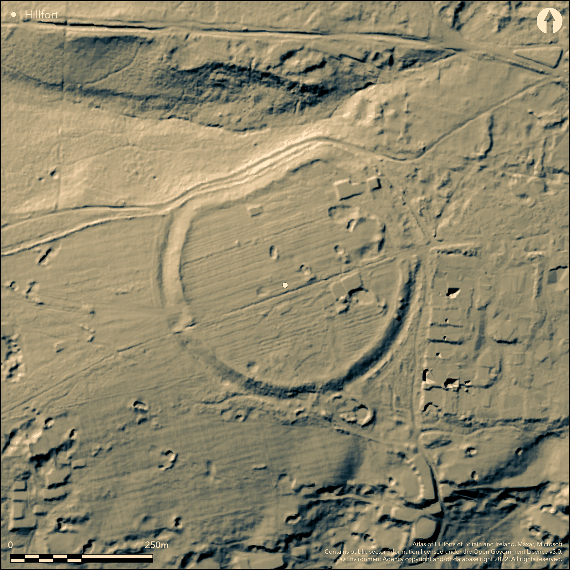
LiDAR 1m DTM Hillshade
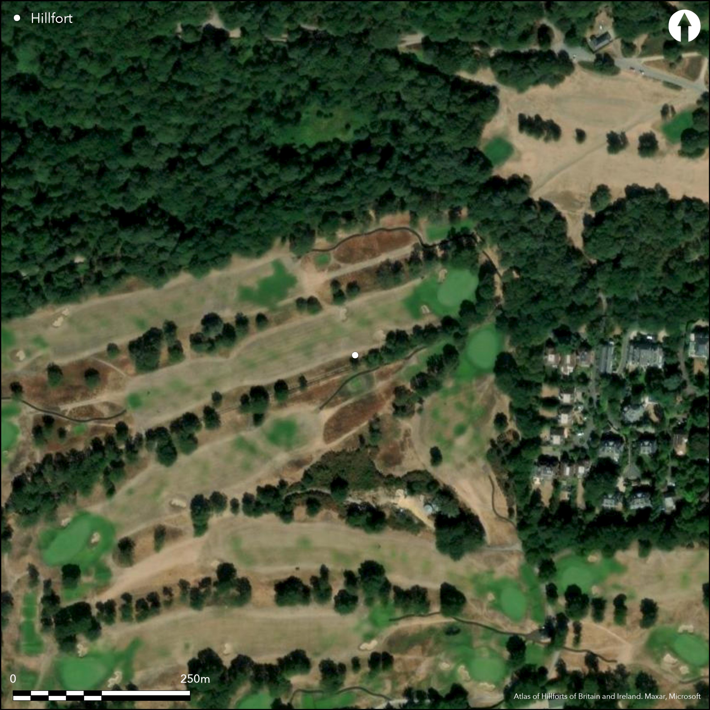
Satellite Imagery
LiDAR 1m DTM Hillshade
Satellite Imagery
Scroll left/right to view further images.
HER: Greater London MLO10722 (None)
NMR: TQ 27 SW 6 (401301)
SM: 1002014
NGR: TQ 2239 7108
X: 522390 Y: 171080 (OSGB36)
A large univallate hillfort of 4.6 ha within Royal Wimbledon Golf Course on Wimbledon Common. Surviving in places as earthworks, it occupies a blunt spur at 51m OD. Approximately 300m in diameter but flattening in the NW where it follows the steeper slopes of the spur. A counterscarp bank follows the rampart in the S. Excavation showed that the bank had been revetted with timber on both faces (Lowther 1945). An entrance, 20m wide lies in the W, denoted by a weakening of the bank and a causeway across the ditch. The cropmark of a rectangular building on the N side of the entrance is considered to be a 19th century gamekeepers cottage. Partial excavation in 1937 (ibid.) during the digging of a water mains trench, showed that the ditch was 9m wide and 3.5m deep. Dated by pottery to about the 3rd century BC possibly continuing into the late Iron Age. An urn containing a possible 1st century coin hoard also recovered. A small pit, posthole and a metalled surface was observed on the western approach of the hillfort during a watching brief (Roycroft 1997). It was also noted that medieval/post-medieval ploughing had removed any in-situ stratigraphy inside the fort, leaving only deep-cut features which cut into the natural gravel. The bank and ditch are now eroded through landscaping. Recorded on 1874 1:10,560 OS mapping. Scheduled
Citizen Science: ✗
Reliability of Data: Confirmed
Reliability of Interpretation: Confirmed
X: -26829 Y: 6696902 (EPSG: 3857)
Longitude: -0.2410096588550221 Latitude: 51.4254669122374 (EPSG:4326)
Country: England
Current County or Unitary Authority: Greater London Authority
Historic County: Surrey
Current Parish/Community/Council/Townland: None
Eroded through landscaping
| Extant | ✓ |
| Cropmark | ✗ |
| Likely Destroyed | ✗ |
Golf course
| Woodland | ✗ |
| Commercial Forestry Plantation | ✗ |
| Parkland | ✗ |
| Pasture (Grazing) | ✗ |
| Arable | ✗ |
| Scrub/Bracken | ✗ |
| Bare Outcrop | ✗ |
| Heather/Moorland | ✗ |
| Heath | ✗ |
| Built-up | ✗ |
| Coastal Grassland | ✗ |
| Other | ✓ |
A contour fort occupying a blunt spur at 51m OD.
| Contour Fort | ✓ |
| Partial Contour Fort | ✗ |
| Promontory Fort | ✗ |
| Hillslope Fort | ✗ |
| Level Terrain Fort | ✗ |
| Marsh Fort | ✗ |
| Multiple Enclosure Fort | ✗ |
| Hilltop | ✓ |
| Coastal Promontory | ✗ |
| Inland Promontory | ✗ |
| Valley Bottom | ✗ |
| Knoll/Hillock/Outcrop | ✗ |
| Ridge | ✗ |
| Cliff/Plateau-edge/Scarp | ✗ |
| Hillslope | ✗ |
| Lowland | ✗ |
| Spur | ✗ |
Dominant Topographic Feature: Spur
| North | ✗ |
| Northeast | ✗ |
| East | ✗ |
| Southeast | ✗ |
| South | ✗ |
| Southwest | ✗ |
| West | ✗ |
| Northwest | ✓ |
| Level | ✗ |
Altitude: 51.0m
N/A
Dated by pottery to the 3rd century BC and possibly into the late Iron Age. A 1st century coin hoard was also recovered.
Reliability: B - Medium
| Pre 1200BC | ✗ |
| 1200BC - 800BC | ✗ |
| 800BC - 400BC | ✗ |
| 400BC - AD50 | ✓ |
| AD50 - AD400 | ✗ |
| AD400 - AD 800 | ✗ |
| Post AD800 | ✗ |
| Unknown | ✗ |
| Pre Hillfort: | None |
| Post Hillfort: | None |
| Artefactual: | None |
Reference in Aubrey's Monumenta Britannica (1665-1693). Described by Lysons (1792). Recorded on 1874 1:10,560 OS mapping. Excavated in 1937. Watching brief in 1997 during works related to the golf course. Field investigations in 1960 and 1965. Scheduled.
| 1st Identified Map Depiction (1874): | None |
| Other (1932): | Scheduled |
| Excavation (1937): | None |
| Other (1960): | Field investigation |
| Other (1965): | Field investigation |
| Other (1975): | Visit by Hillfort Study Group |
| Other (1997): | Watching brief |
| 1st Identified Written Reference (None): | None |
Any internal features are probably destroyed by ridge and furrow ploughing
Beverley Brook lies to the W
| None | ✓ |
| Spring | ✗ |
| Stream | ✗ |
| Pool | ✗ |
| Flush | ✗ |
| Well | ✗ |
| Other | ✗ |
Probable gamekeepers cottage
| No Known Features | ✗ |
| Round Stone Structures | ✗ |
| Rectangular Stone Structures | ✗ |
| Curvilinear Platforms | ✗ |
| Other Roundhouse Evidence | ✗ |
| Pits | ✗ |
| Quarry Hollows | ✗ |
| Other | ✓ |
None
| No Known Excavation | ✓ |
| Pits | ✗ |
| Postholes | ✗ |
| Roundhouses | ✗ |
| Rectangular Structures | ✗ |
| Roads/Tracks | ✗ |
| Quarry Hollows | ✗ |
| Other | ✗ |
| Nothing Found | ✗ |
None
| No Known Geophysics | ✓ |
| Pits | ✗ |
| Roundhouses | ✗ |
| Rectangular Structures | ✗ |
| Roads/Tracks | ✗ |
| Quarry Hollows | ✗ |
| Other | ✗ |
| Nothing Found | ✗ |
Coin hoard
| No Known Finds | ✗ |
| Pottery | ✓ |
| Metal | ✗ |
| Metalworking | ✗ |
| Human Bones | ✗ |
| Animal Bones | ✗ |
| Lithics | ✓ |
| Environmental | ✗ |
| Other | ✓ |
None
| APs Not Checked | ✓ |
| None | ✗ |
| Roundhouses | ✗ |
| Rectangular Structures | ✗ |
| Pits | ✗ |
| Postholes | ✗ |
| Roads/Tracks | ✗ |
| Other | ✗ |
An entrance, 20m wide lies in the W, denoted by a weakening of the bank and a causeway across the ditch
| 1: | None |
| 2: | None |
Guard Chambers: ✗
Chevaux de Frise: ✗
| 1. Simple Gap (West): | None |
Large univallate hillfort. Approximately 300m in diameter but flattening in the NW where it follows the steeper slopes of the spur. A counterscarp bank follows the defences in the S. Excavation showed that the bank had been revetted with timber on both faces and the ditch to be 9m wide and 3.5m deep.
| Area 1: | 4.6ha. |
| Total: | 4.6ha. |
Total Footprint Area: Noneha.
None
| ✗ | None |
| ✓ | None |
| NE Quadrant: | 1 |
| SE Quadrant: | 1 |
| SW Quadrant: | 1 |
| NW Quadrant: | 1 |
| Total: | 1 |
| Partial Univallate | ✗ |
| Univallate | ✓ |
| Partial Bivallate | ✗ |
| Bivallate | ✗ |
| Partial Multivallate | ✗ |
| Multivallate | ✗ |
| Unknown | ✗ |
| Partial Univallate | ✗ |
| Univallate | ✗ |
| Partial Bivallate | ✗ |
| Bivallate | ✗ |
| Partial Multivallate | ✗ |
| Multivallate | ✗ |
None
| None | ✗ |
| Earthen Bank | ✓ |
| Stone Wall | ✗ |
| Rubble | ✗ |
| Wall-walk | ✗ |
| Evidence of Timber | ✗ |
| Vitrification | ✗ |
| Other Burning | ✗ |
| Palisade | ✗ |
| Counter Scarp Bank | ✓ |
| Berm | ✗ |
| Unfinished | ✗ |
| Other | ✗ |
None
| None | ✗ |
| Earthen Bank | ✓ |
| Stone Wall | ✗ |
| Murus Duplex | ✗ |
| Timber-framed | ✓ |
| Timber-laced | ✗ |
| Vitrification | ✗ |
| Other Burning | ✗ |
| Palisade | ✗ |
| Counter Scarp Bank | ✗ |
| Berm | ✗ |
| Unfinished | ✗ |
| No Known Excavation | ✗ |
| Other | ✗ |
| ✗ | None |
| ✓ | None |
Number of Ditches: 1
| ✗ | None |
Kempe, A.J. 1846. On an Intrenched Camp at Wimbledon, in Surrey, and on the termination don or dune in that name. Archaeologia 31, 518-21
Lowther, A.W.G. 1945. Caesar's Camp, Wimbledon, Surrey; the excavations of 1937. Arch J. 102 15-20
Lysons, D. 1792. Wimbledon, in The Environs of London: Volume 1, County of Surrey. London. 519-540 https://www.british-history.ac.uk/london-environs/vol1/pp519-540. Accessed January 2016
Roycroft, N. 1997. Caesar's Camp, Royal Wimbledon Golf Club, SW19, London Borough of Merton. An Archaeological Watching Brief. Museum of London Archaeological Service.
Tregellas W. H. 1866. Caesar's Camp, Wimbledon. Arch. J. xxiii. 261-269
Atlas of Hillforts:
Wikidata:
This work is licensed under CC BY-SA 4.0

 and should be cited as:
Lock, Gary and Ralston, Ian. 2024. Atlas of Hillforts of Britain and Ireland. Available at: https://hillforts.arch.ox.ac.uk
Document Version 1.1